
Journal of Oil and Gas Research Reviews(JOGRR)
ISSN: 2993-3617 | DOI: 10.33140/JOGRR
Impact Factor: 0.7


Research Article - (2024) Volume 4, Issue 1
Structural Evolution and Hydrocarbon Accumulation Conditions of the Strike-Slip Pull-Out Basin in the Central African Rift System: A Case Study of the Doseo Basin in Chad
2Research Institute of Petroleum Exploration and Development, PetroChina; Beijing, China
Received Date: Sep 05, 2024 / Accepted Date: Oct 28, 2024 / Published Date: Nov 07, 2024
Copyright: ©Â©2024 MA Hong, et al. This is an open-access article distributed under the terms of the Creative Commons Attribution License, which permits unrestricted use, distribution, and reproduction in any medium, provided the original author and source are credited.
Citation: Hong, M. A., Yebo, D., Li, W., Zhaoming, W., Lin, W., et. al. (2024). Structural Evolution and Hydrocarbon Accumulation Conditions of the Strike-Slip Pull-Out Basin in the Central African Rift System: A Case Study of the Doseo Basin In Chad. J Oil Gas Res Rev, 4(1), 01-12.
Abstract
Doseo Basin is the key block of CNPC's overseas oil and gas exploration currently in Chad, and important oil and gas discoveries have been made in recent years. Based on the latest drilling and seismic data, utilize geochemical analysis data, this paper systematically analyzes the tectonic evolution and basic petroleum geological conditions and hydrocarbon accumulation in the CNPC’s blocks of Doseo Basin, and identifies the next favorable exploration areas.
Three mainly stages of tectonic evolution and three sets of favorable source rocks are mainly developed in Doseo Basin. The Kedeni Formation source rocks have large thickness, wide distribution, good organic matter type and high maturity, are the most favorable reservoir formation conditions. The fault system formed by multi-stage tectonic activities provides convenient channels for oil and gas migration and accumulation. The reservoir formation assemblages are dominated by lower generated and upper stored assemblages of Kedeni Formation. Many types of structural traps are developed, such as anticline, fault anticline, fault nose and fault block. The central depression is the main source of hydrocarbons generation, and hydrocarbons migrated closed vertically and laterally along faults formed structural reservoirs near the central depression. On the basis of this analysis, the next favorable exploration fields in the study area are defined. The structure-lithologic reservoirs in the north steep slope zone and the south slope zone, and the oil and gas exploration in the deep Mangara Formation are mainly the next favorable exploration areas. The research results point out the direction for the follow-up exploration in the study area, and it is hoped to open a new situation of exploration and consolidate the resource base for increasing oil and gas storage and production in Doseo Basin.
Keywords
Doseo Basin, Lower Cretaceous, Source Rock Evaluation, Tectonic Evolution; Petroleum Migration, Exploration Potential
Introduction
The Republic of Chad (chad for short), located in the central region of Africa, is rich in oil and gas resources [1]. Affected by the "Central African Shear Zone" formed by the disintegration of the African continent in the late Mesozoic era, a series of Me-sozoic Cenozoic rift basins have developed in Chad, including Bongor Basin, Lake Chad Basin, Madiago Basin, Doba Basin, Doseo Basin, Salamat Basin and other basins. The exploration of oil and gas began in the 1960s in Chad. After more than forty years of exploration, most of international oil companies thought that the potential of oil and gas resources in Chad was poor, and they withdrew successively. In 2007, China National Petroleum Corporation (Hereinafter referred to as CNPC) obtained the sole right of operation about Block H in Chad, and made a series of oil and gas exploration discoveries in the Bongor Basin. In addi¬tion CNPC has two exploration blocks in the central and eastern part of the Doseo Basin in Chad. Based on the early drillings and seismic data, predecessors have done some studies on the tectonic evolution and basic conditions of petroleum geology of the Doseo Basin [2-5]. However, the research degree was rela¬tively low because of the limitation by basic data, the analysis of reservoir formation conditions and data support were not deep enough, the summary of reservoir conditions was not perfect and the favorable exploration fields were not clear. In the past two years, CNPC had further increased the workload and investment in the exploration block of the Doseo Basin and created a new situation in oil and gas exploration. Based on the latest seismic and drilling data in CNPC exploration blocks of the Doseo Basin in the past two years, on the basis of previous studies and through the analysis and support of large number of basic data, this paper further analyzed the regional structural evolution characteristics of the Doseo Basin and the conditions of hydrocarbon reservoir, summarized the hydrocarbon accumulation law and pointed out the favorable exploration areas. It strived to point out the direc¬tion for the oil and gas exploration deployment and further major breakthroughs in the future.
Regional Geological Overview
The Doseo Basin is located in the south of Chad and belongs to the middle part of the Central African shear zone structurally which is approximately 500 kilometers long from east to west and 60 kilometers long from north to south, covering an area of nearly 50000 square kilometers. It has a long and narrow dis¬tribution pattern from northeast to southwest and it forms the "South Chad Basin Group" together with the Doba Basin on the west side and the Salamat Basin on the east side[3,5]. The main body of the Doseo Basin has an alternate tectonic pattern of up¬lift and depression. From west to east, four first-order structural units are developed, successively: western depression, western uplift, central depression and eastern uplift. From north to south, three second-order structural units are developed successively: northern steep slope belt, central tectonic belt and southern gen¬tle slope belt(Fig. 1). The CNPC exploration area is mainly lo¬cated in the central and eastern part of the basin. The structural units of CNPC exploration blocks can be divided into five sec¬ondary structural units from north to south: northern steep slope belt, Kibea sag, central low bulge belt, Kedeni sag and southern gentle slope belt. The northern steep slope zone is near the center of the depression. The central low bulges belt is an uplift in de¬pression and the north and south sides are Kibea sag and Kedeni sag respectively. The southern gentle slope zone is a monoclinal structure that has been uplifted along the south direction.

Figure 1: Geographical Location and Tectonic Zoning Map of the Doseo Basin
The basement of the Doseo Basin was pre-Cambrian granite and the overlying sedimentary strata from bottom to top were respectively the Lower Cretaceous Mangara formation, Kedeni formation, Doba formation and Koumra formation, the Upper Cretaceous K2Lâ?»K2U and Tertiary sedimentary strata. The lower Cretaceous sedimentary strata were the main exploration target strata in the Doseo Basin. The Mangara formation was deposited in the period of the basin fault depression with the thickness about 1000ï½?3500m, and the sedimentary environment was fluvial-lacustrine facies. Kedeni formation was deposited during the fault-depression period of the basin with the thickness about 700ï½?1500m, and the sedimentary environment was delta facies. Doba formation and Koumara formation were deposited during the depression period with a thickness about 350ï½?800m and 250ï½?650m respectively and the sedimentary environment was fluvial-delta-lacustrine facies. (Fig. 2).

Figure 2: Comprehensive Column Map of Sedimentary Strata in the Doseo Basin
Characteristics of Basin Tectonic Evolution
The Doseo Basin was a passive rift basin formed by strike-slip shear and inversion on the basis of regional plate tectonic activities [6-10]. It mainly experienced three evolution stages: Early Cretaceous fault depression(Mangara formation sedimentary period), mid-Early Cretaceous fault depression transition(Kedeni formation sedimentary period), and late Early Cretaceous-Quaternary depression(Doba formation sedimentary period-Quaternary period).
Early Cretaceous Fault Depression (Mangara Formation Depositional Period)
At the beginning of the Early Cretaceous, the South Atlantic gradually opened up from south to north (Fig. 3a). Influenced by the fragmentation and separation of Africa and South America, the Central African lithosphere began to activate and the Central African shear belt was extended by the near-north-south tension force, resulting in the fault depression of the Doseo Basin and the formation of the prototype rift basin [6-14]. During this period the southern dip basement extensional fault system formed mainly in the eastern part of the basin under the influence of north-south tension and extension stress, in which the northern boundary fault F1 was a first-order basin-controlled fault and the internal fault F2â?»F4 were a series of second-order depression- controlled faults derived from the same period(Fig. 4). Three half loop fault sags namely Celtis, Kibea and Kedeni were developed from north to south respectively, which were controlled by three superhalf graben-like faults from north to south.
The overall performance was deep in the north and shallow in the south. Analysis the character of the major fracture systems in the study area showed that the faults distribution were approximately parallel in the direction of NEE-SWW and E-W. This inferred the principal stress of extension direction was nearly from south to north(Fig. 4). In the middle of the basin, due to the proximity to the subsidence center of the basin, the fault structure has changed accordingly, and several half graben-like fault depressions have transformed into north-south double-fault central fault depressions. The north-dipping basement extension fault F5 developed in the southeast margin of the western part of the study area, which also confirmed the north-south double-fault structure in the western part of the study area. This period was the fault depression deposition period of the Doseo Basin, mainly composed of coarse-grained sediments of Mangara formation. According to seismic data, the sedimentary thickness ranges was from 1000m to 3500m and the thickness of the sedimentary center could reach more than 4000m.
Mid-Early Cretaceous Fault-Depression Transition (Kedeni Formation Depositional Period)
In the middle of the Early Cretaceous the equatorial South Atlantic began to develop due to the gradual expansion of the South Atlantic northward towards the equator [7,10-12,15]. Influenced by the difference in spreading rate and direction between the Middle Atlantic and the South Atlantic, the equatorial South Atlantic opened in the form of right-lateral shear tension, in other words, the West African and East African basin groups moved to the right relative to the South American plate and the tectonic stress field of the Central African Rift basin group changed from the near N-S extension in the Early Cretaceous to the near E-W right-lateral tension-torsional strike-slip shear in the middle of the Early Cretaceous. The sedimentary period of Kedeni formation in the basin was in the transition period from extensional structure to strike-slip stress field and the faults F1â?»F4 were still in the active stage which still controlled the deposition of Kedeni formation, but the north-south superhalf graben fault depression in the eastern part of the basin has basically disappeared]10-14]. A number of separated lake basins developed in the fault depression period were connected into one lake basin, and the basin area expanded significantly. The right-lateral tensional-torsion strike-slip fault system of the basin began to develop. At this time the Doseo Basin was in the filling and replenishment period of Kedeni formation with the characteristics of fault-depression transition.
Late Early Cretaceous-Quaternary Depression (Doba Formation-Quaternary Deposition Period)
In the late Early Cretaceous, continuous shear and tension in the equatorial South Atlantic(Fig. 3b) influenced by the stress field of the Central African shear strike-slip structure, the growth of the north-south fault in the Doseo Basin stopped and the basin entered the depression period with the development of right-lateral tension-torsion strike-slip faults and two stages of inversion structures 3,6,7-10,13,14].
Right-Lateral Tension-Torsion Strike-Slip Fault of Inheritor Activity (Doba-Koumra Formation Deposition Period)
Under the influence of the opening of the right shear in the equatorial South Atlantic, the Central African shear zone changed from the near S/N extension to the near E/W right tensile shear in the late Early Cretaceous, resulting in the development of the right tensional strike-slip fault system in the Doseo Basin(Fig. 4). Faults F2ï½?F5, controlled by the right-lateral strike-slip activity of the main shear fault F1, were also transformed into a right-lateral tension-slip shear fault, in which F2ï½?F3 was a R-shear fault(Riedle’s co-axial shear fault, interesting with the main shear zone at an Angle of 10°Ã¯Â½?30°,with the sharp tip of the intersection pointing to the displacement direction of the same fault wall) and fault F4ï½?F5 was a P-shear fault(roughly symmetric with R-shear relative to the main shear zone, the shear direction was also consistent with the main shear zone, and the sharp Angle tip pointed to the displacement direction of the opposite fault wall). A large number of NW-SE to NWW-SEE tension-shear faults and a small number of NE-SE reverse faults developed in the basin at an acute angle oblique to the main F1 ï½?F5 shear faults, thus formed the right-lateral tension-torsion strike-slip fault system in the Doseo Basin(Fig. 4), which began to develop from the middle and late Early Cretaceous and lasted until the late Late Cretaceous that was interrupted only briefly by the early Late Cretaceous reversal event during this time.
Early Late Cretaceous Right-Handed Compression-Torsion Inversion Structure (K2l Sedimentary Stage)
In the early Late Cretaceous under the subduction influence of the South New Tethys Ocean to the north, the convergence of the Africa-Arabian plate and Eurasia led to regional unconformity and a series of fold belts[16-18] during the Upper Cretaceous deposition in the eastern margin of North Africa. At this time, the right-lateral shear tension of the south equatorial Atlantic was still in progress [10-16]. Under the influence of the convergence of the Africa-Arabian plate and Eurasia and the right-lateral strike-slip of the Central African shear belt itself, the Doseo Basin experienced right-lateral compression-torsion inversion and regional unconformity and related fold deformation structures were widely developed. En echelon NE-SW nose uplift developed due to strong fold deformation, which mainly distributed around the northern steep slope zone and the central low bulge zone in the eastern part of the basin. Since then, the convergence of the Africa-Arabian plate and Eurasia has weakened (possibly related to the increasing subduction angle of the South New Tethys Ocean), and the Central Africa shear belt has turned to right-handed tension-twist strike-slip, resulting in a series of NW-SE trending strike-slip faults in the Doseo Basin, which cut the En echelon nose uplift due to fold deformation in the earlier period. During this period, the K2L formation was mainly deposited with medium and coarse grains, and the obvious truncation and unconformity contact showed in the seismic section [13-18].
Strong Compressional Inversion Structure At the End of Late Cretaceous (K2u Sedimentary Stage)
At the end of the Late Cretaceous, the Middle Atlantic and the South Atlantic were connected as a whole ocean(Fig. 3c), the differential expansion disappeared and the expansion of the equatorial South Atlantic was no longer affect the activities of the Central African shear zone[7,10,12-15]. Due to the increasing convergence of the Africa-Arabian plate and Eurasia, the Doseo Basin was strongly uplifted, denuded and re-compressed, forming a regional tectonic unconformity at the top boundary of the Cretaceous, resulting in a near east-west tectonic pattern of the pre-inverted tectonic superposition and the tectonic framework of the basin was basically formed. During this period K2U formation strata were mainly deposited characteristic with coarse-grained, which showed the obvious angular unconformity on the top surface of the Cretaceous in the seismic section. After that the basin entered the extinction period and the Paleogene, Neogene and Quaternary strata were deposited.

Figure 3: Schematic Diagram of The Disintegration Process of Gondwana Since the Early Cretaceous (cited in reference)

Figure 4: Schematic Diagram of Fault Development Under the Influence of Tectonic Movement in the Doseo Basin
Analysis of Hydrocarbon Accumulation Conditions
The Doseo Basin has undergone three evolutionary stages: fault-depression period(Mangara formation sedimentary period), fault-depression transition period(Kedeni formation sedimentary period) and depression period(Doba formation sedimentary period-Quaternary sedimentary period). Multi-stage tectonic evolution movements had great influence on the development and distribution of source rock, reservoirs, trap formation and preservation, hydrocarbon migration and accumulation [13]. The development of fault system provided a favorable transport system for oil and gas migration and accumulation, it was also not conductive to the formation and preservation of oil and gas reservoirs. Therefore by analyzing and studying the petroleum geological conditions and hydrocarbon accumulation, and guiding the further exploration deployment were the top priority in the current exploration of the Doseo Basin.
Source Rock Analysis
Through exploration practice showed that three sets of source rocks were mainly developed in the Doba formation of Lower Cretaceous depression, Kedeni formation of fault depression transition and Mangara formation of fault depression in the Doseo Basin. Among them, the main source rocks were lacustrine dark mudstone deposited in Kedeni formation during the fault depression period, the secondary source rocks were lacustrine dark mudstone of Doba formation during the depression period and the thin layer grayish black-black mudstone developed in the upper part of Mangara formation during the fault depression period [4].
The source rocks of the Kedeni formation could be divided into two sets of source rocks in the upper and lower member of the Kedeni formation and the dark mudstones in the lower member were the most favorable. During the fault-depression transition period, the lake water expanded continuously, mainly filled and replenishment deposits. Although the basement faults and basin control faults were still active, the overall sedimentary environment was relatively stable due to the influence of multiple loop fault basins, and the dark mudstone deposits of semi-deep lacustrine facies developed in a large area in the basin, forming the main source rock in the basin. According to the drilling data, the cumulative thickness of the effective source rocks in Kedeni formation in the basin was up to 600m(Fig. 5, data from the drilled exploration well in the CNPC exploration area), and the average effective thickness was 260m. The organic matter types were mainly type I and type II1 was occasionally seen(Fig. 6). The organic carbon content was high, the main range was 1% ~ 6% and the average was 3.6%. The main range of maturity of organic matter was 0.5% ~ 1.3%, which belonged to the mature to high mature stage. Near the subsidence center of the central depression, the effective source rocks had large thickness and high organic carbon content, and the maturity of organic matter reached the high maturity stage. At the edge of the basin, the source rocks were poor. The results of the basin simulation based on drilling data showed that the effective source rocks of Kedeni formation with organic carbon content greater than 2% and cumulative thickness greater than 50m were distributed over an area of 4150km2, with an average hydrocarbon generation potential of 18.6mg/g and a maximum hydrocarbon expulsion intensity of 400×104t/km2.
The source rocks of the Doba formation were mainly developed in the lower member, and the basin entered the depression sedimentary stage. The dark mudstone with large thickness was developed in the basin as a whole, but the distribution of the dark mudstone varied greatly under the influence of controlled depression faults. According to the drilling data in the CNPC exploration area, the thickness of the effective source rock in Doba formation in the basin was up to about 400m. They were mainly distributed in the center of the depression, with an average effective thickness of more than 100m. The organic matter type II kerogen was the main type(Fig. 6) and the organic carbon content ranged from 0.2% to 4%, with an average of 2.8%. The maturity of organic matter ranged from 0.3% to 0.6%, which belonged to the low-mature to mature stage, and the comprehensive evaluation was poor to medium source rock. Mangara formation was a sedimentary formation in the basin depression period, affected by basement extensional faults and basin control faults and mainly filled with coarse-grained deposits. It was speculated that dark mudstone may be locally developed in the Mangara formation, but the current drilling data in the area only revealed the upper sedimentary strata of the Mangara formation, which were mainly sandstone deposits. According to the data statistics revealed by drilling, the cumulative thickness of the dark mudstone of Mangara formation exceeded 100m. The organic matter type was mainly I-II1 type(Fig. 6). The organic carbon content ranged from 1.5% to 6.0%, with an average of 4.5%. The maturity of organic matter ranged from 0.8% to 1.5%, which belonged to mature to over-mature stage that was a good source rock comprehensively evaluated.

Figure 5: Planar Distribution Map of Source Rock Thickness in Kedeni Formation, Doseo Basin (the location is shown in Fig.1 the scope of the research area, drilling data from CNPC exploration area)
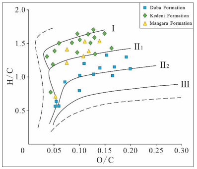
Figure 6: Map of Organic Matter Types Division in Doseo Basin (samples from CNPC exploration area)
Reservoir Analysis
The Doseo Basin experienced three evolutionary stages in the Early Cretaceous and several sets of favorable reservoir sandstone developed in the Lower Cretaceous sedimentary strata, mainly delta front sandstone, coastal shallow lacustrine sandstone and fan delta sandstone. The favorable reservoir sandstone developed in Doba formation, Kedeni formation and upper Mangara formation. The favorable reservoirs of Doba formation in the basin had relatively good physical properties with the porosity mainly ranging from 12% to 36% and the average porosity was 22%. The permeability was mainly between 100mD to 3200mD and the average permeability was 1160mD (statistical results of sample analysis). The reservoir physical properties were mainly medium-high porosity and medium-high permeability (Fig. 7). Kedeni formation was the main reservoir in the basin and the sedimentary strata were mainly sand-mudstone interbedded deposits in river delta and shore-shallow lake. The reservoir had good physical properties with porosity ranging from 10% to 28% and the average porosity was 18%. The permeability ranged from 50mD to 2400mD and the average permeability was 480mD (statistical results of sample analysis). The reservoir physical properties were mainly mesoporous and permeable (Fig. 7). The drilling data revealed that the overall physical properties of the Mangara formation reservoir were poor. Due to the relatively large burial depth and strong diagenesis, the porosity ranged from 8% to 20% with an average porosity of 13%. The permeability mainly ranged from 20mD to 1200mD and the average permeability was 100mD (statistical results of sample analysis). The reservoir physical properties were mainly medium-low porosity and medium-low permeability (Fig. 7). Based on the seismic data combined with the analysis of sedimentary facies and drilling data, the comprehensive evaluation of the Lower Cretaceous sedimentary reservoir in the CNPC exploration area showed that the overall reservoir in the middle-eastern part of the basin was relatively developed, while the reservoir near the subsidence center was not developed (Fig. 8).

Figure 7: Relationship Between Porosity and Permeability of The Doseo Basin (sample data from CNPC exploration area)
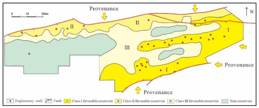
Figure 8: The Map of Favorable Reservoir Comprehensive Evaluation in The Middle-Eastern of The Doseo Basin
Caprock Analysis
Affected by multiple tectonic movements, the Doseo Basin developed several sets of caprocks in the Lower Cretaceous sedimentary strata, mainly prodelta mudstone and semi-deep lake - deep lake mudstone. The favorable caprocks were mainly pre-delta mudstone deposited during the fault-depression transition period and semi-deep lacustrine facies mudstone deposited during the depression period. The thickness of the effective mudstone monolayer in Doba formation mainly ranged from 5m to 12m, and the thickness of the monolayer near the center of the depression gradually increased and could reach 20m to 30m in some areas, which could be used as the local effective caprock for oil and gas accumulation in Doba formation. Both the upper and lower members of Kedeni formation developed regional dark mudstone, which could be used as an effective caprock for favorable reservoirs. The thickness of the upper mudstone monolayer was relatively thinning, mainly ranging from 10m to 15m, and the thickness of the lower mudstone monolayer was about 20m to 60m. Near the basin depression, the thickness of the dark mudstone monolayer gradually increased. In the southern slope of the basin margin, the Kedeni formation could still develop relatively stable mudstone, although the thickness was thinning, the local area could still be effectively capped. However in the eastern of the basin margin the mudstone of the Kedeni formation was dark red, which suggested that the cap layer of the Kedeni formation was poorly sealed. The cap layer of Mangara formation was mainly the dark mudstone at the bottom of overlying Kedeni formation, with a thickness of about 10m to 25m. In the basin depression, the thickness of the dark mudstone could reach more than 50m. The upper layer of Mangara formation also had a relatively large single layer of mudstone in the central depression of the basin, which could be used as a local effective cap layer. There was a trend of improvement in the cap rock conditions from the Doba Formation to the lower section of the Kedeni Formation. On a plane analysis, the western part had better cover conditions than the eastern part in the basin.
Analysis of Trap And Preservation Conditions
Under the influence of the Central African shear strike-slip structure, the Doseo Basin has undergone multi-stage tectonic activities, formed multi-stage fault system, and developed various types of structural traps. The main types of traps were anticlines formed by inversion, faulted anticlines, and fault noses and blocks related to strike slip faults. The northern steep slope zone mainly developed forward fault blocks formed by extension, and anticlines and fault noses formed by reverse compression. The central low bulge belt developed the flower shaped structure formed by the development of strike slip superposition and later reversal, with the "flower center" mostly being an anticline and the "lace" being a reverse fault nose or fault block. The southern slope developed reverse and forward tilting fault blocks, and locally developed compression anticlines. The right-lateral tension-strike-slip tectonic activity of the middle and late Early Cretaceous to the early Late Cretaceous was the main period of trap formation in the basin and the key period of hydrocarbon generation, migration and accumulation [8-10].A series of NNW En sequence structural traps developed in the eastern uplift of the basin during this period, which were distributed in a fish-like pattern along the northern and southern sides of the central low uplift zone. In the central depression and the western part of the basin, NEE-trending parallel structural traps which were controlled by faults mainly developed.
In the fault development zone, fault sealing was the main influence factor on the favorable conditions for oil and gas accumulation and preservation in the basin. Whether it was a normal fault or a reverse fault, the fault sealing property depended on the displacement pressure of the butt rock on both sides of the fault. When the rocks on both sides of the fault were sandstone and mudstone butt, the displacement pressure of the rock layer was relatively large, and the fault sealing property was relatively good, which was conductive to the oil and gas preservation. On the contrary, when the lithology on both sides of the fault was sandstone butt, the displacement pressure of the rock layer was relatively small and the fault sealing was relatively poor, which was not conductive to the oil and gas preservation [19-26].The Doba formation deposits in the uplift area of the basin were mainly sandstone, and the fault section dip angle was small, the buried depth was small, the fracture pressure and rock displacement pressure were small, which was not conducive to the oil and gas preservation. Close to the basin depression, the lower part of the formation had local mudstone development, large single-layer thickness, and better lateral sealing property than the upper part, which was conducive to the oil and gas preservation. This recognition was also confirmed by the discovery of fault-block oil and gas reservoirs in the lower member of Doba formation in the western part of the central low bulge belt and the northern steep slope belt near the depression area of the CNPC exploration area. The Kedeni formation mainly developed sand-mudstone interbedded deposited of delta facies and shore-shallow lake facies, and the sand-mudstone interbedded deposits on both sides of the fault were more likely to be interbedded and the fault dip angle and burial depth of the Kedeni formation were relatively large, and the rock displacement pressure on both sides of the fault was relatively large, which was conducive to the oil and gas preservation. When the upper sandstone of Mangara formation and the bottom mudstone of Kedeni formation were jointed on both sides of the fault, the fault was well sealed and the reservoir property of Mangara formation in the uplift area of the basin was relatively good, and oil and gas were easy to be preserved and formed hydrocarbon reservoirs. This view was also confirmed by the discovery of oil and gas at the top of Mangara formation and inside of Kedeni formation in the revers fault block in the Doseo Basin.
Analysis of Hydrocarbon Accumulation
The relationship between oil, gas and water layers in the Doseo Basin was complicated, most of the oil and gas reservoirs were not full enough, about 30% on average, which also lead to the diversity of oil and gas accumulation in the basin. From the study of the distribution characteristics of oil and gas reservoirs that have been discovered, it could be seen that oil and gas migration exhibited the characteristic of "near source accumulation". The central depression, as the main hydrocarbon generation center of the basin, controlled the distribution range of most oil and gas reservoirs in the basin. The distribution of oil and gas reservoirs on the plane had the characteristics of mainly central uplift and supplemented by north-south structural zones(Figure 9). From the analysis of the basin, multiple oil and gas systems were developed during the Lower Cretaceous depression period such as lower generated and upper stored, self-generated and self-stored. After oil and gas generation, they migrated vertically or laterally to adjacent sand bodies to form reservoirs. Part of the oil and gas can also accumulate into reservoirs after migrating a certain distance through developed fault systems. The northern slope zone was close to the central hydrocarbon generation center and was influenced by the boundary controlled basin faults, the strata were buried deep, and the traps near the central depression structural zone were mainly gas reservoirs. The traps of the structural zone near the basin boundary to the north were buried shallowly and were mainly oil reservoirs. The central and western parts of the central low bugles zone were close to the hydrocarbon generation center of the central depression, and Kibea sag and Kedeni sag were developed on both sides of it, the oil and gas filling conditions were very good and most of the traps were filled with oil reservoirs, locally buried deep traps were mainly filled with gas. The eastern edge of the central low bulges zone was far from the hydrocarbon generation center, and the hydrocarbon generation and migration and accumulation abilities were poor, most of the traps could not form reservoirs (Figure 9). Part of the oil and gas generated in the southern Kedeni sag gradually degraded after migrating southeastward for a certain distance due to shallower burial. At the same time, due to the structural uplift, the preservation conditions have deteriorated. Therefore, the oil reservoirs in the southern slope zone were mainly relatively heavy oil.

Figure 9: Schematic Diagram of Oil and Gas Migration and Accumulation
Analysis of Exploration Potential
At present, with the continuous improvement of the exploration degree in the block, the area and number of structural traps in the central and eastern parts of the basin are decreasing day by day, and it is becoming more and more difficult to discover large-scale reserves. However, through the whole study and analysis of the basin, it is concluded that the oil and gas exploration in the Doseo Basin still has a large exploration potential. The deep buried Mangara formation had large sedimentary thickness and few exploration wells drilled to the lower-middle member of this group in the basin, but there were more discoveries at the top of the group and the exploration potential has begun to show. The sedimentary period of this group was the fault depression period of the basin early formation, with a long deposition time (more than 20Ma) and large deposition thickness(1000â?»3500m), which had the basic conditions for oil and gas accumulation in the early stage. Because the fault system formed by the Late Cretaceous tectonic activities mainly affected the sedimentary and structure of Kedeni-Doba formation, and it had little influence on the sedimentary strata of early Mangara formation, the internal faults of Mangara formation were relatively small, and the controlling trap fault activity period was relatively short, the oil and gas reservoirs formed by early sedimentation were not easy to be destroyed. According to the seismic profile analysis, a set of strong reflection axes was locally developed in the middle and upper part of the Mangara formation (Fig. 10), which was believed to be fine-grained sediments and that was presumed to be favorable source rocks of the Mangara formation, and several structural traps have been identified in the Mangara formation(Fig. 10), which was expected to become a potential area for subsequent exploration in the basin. The exploration practices in Bohai Bay Basin and Songliao Basin during the fault depression period in China also confirmed that early oil and gas accumulation existed in the sedimentary strata of the fault depression period in the early basin formation which was the key field of oil and gas exploration [27-30]. Compared with the middle and shallow strata of the central low bulge zone in the eastern region, the exploration degree of the north steep slope zone and the south gentle slope zone was low. At present, oil and gas have been discovered in some parts, but the large-scale scene of oil and gas discovery has not been formed. They are the favorable fields for increasing oil and gas reserves in the future.
The exploration area of the steep slope zone in the northern part of the basin was about 2000km,and favorable reservoirs were the main factors of hydrocarbon accumulation in the low part of the structure, and the preservation conditions were the main factors of hydrocarbon accumulation in the high part of the structure(near the boundary fault). The drilling results showed that the lower part of the structure was close to the center of the oil-generated depression of the basin, and the lower part of the Kedeni formation developed semi-deep lake-deep lake dark mudstone which could be used as favorable hydrocarbon source rock. The upper part of Kedeni formation and Doba formation developed shoal shallow lake facies sandstones and in the upper part of the structure developed fan delta facies sandstones, which were comprehensively evaluated as â? -â?¡ type reservoirs(Fig. 8), that had favorable conditions for oil and gas accumulation, the estimated favorable exploration area was about 1400km2. The exploration area of the southern gentle slope belt was about1300km2, and the caprock condition was the main factor of oil and gas accumulation in this area. It had been proved by drilling that although the Kedeni formation was buried shallowly in the higher part of the structure, local caprocks were developed, and oil and gas could still be effectively formed(such as KS1 well reservoir). In the low structural part, near the hydrocarbon generation depression, the caprock was more developed and the comprehensive evaluation of the reservoir was mainly Class â? (Fig. 8). Both Kedeni formation and Doba formation can be used as exploration target layers and the estimated favorable exploration area is about 900km2, which is the substitute area for subsequent exploration and increased storage of oil and gas.
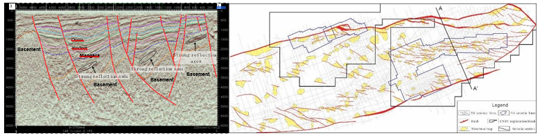
Figure 10: Seismic Interpretation Profile (Left) and Trap Distribution Map (Right) of Mangara Formation in Doseo Basin (seismic data from CNPC exploration area)
In addition, the oil and gas reservoirs found in the basin were all structural pool. Neither structure-lithologic nor lithologic reservoirs had oil and gas discovery that were also have certain exploration potential. The exploration practice of many basins in China had proved that structure-lithology, lithology and stratigraphic lithology traps were easy to develop in the slope zone and near-depression zone of faulted basins [31-35]. Baobab N lithologic oil and gas reservoirs in Bongor Basin have been found in Baobab develop area taking into account exploration through development. This further enhanced the confidence in the oil and gas exploration of the lithologic traps in Doseo Basin. The structural low parts of the northern steep slope belt and the southern gentle slope belt are adjacent to the basin depression area, with geological conditions for the development of structure-lithologsic reservoirs and are the main favorable areas for the next oil and gas exploration to increase reserves [36-45].
Conclusion
• The Doseo Basin in Chad mainly experienced three tectonic evolution stages: fault-depression period, fault-depression transition period and depression period, which controlled the generation and distribution of oil and gas in the basin. The Kedeni formation developed several sets of hydrocarbon accumulation assemblages during the fault-depression transition period, which were the main exploration target strata in the basin.
• Three sets of favorable source rocks were mainly developed in the Lower Cretaceous Doba formation, Kedeni formation and Mangara formation. The Kedeni formation was the main source rock, and its organic matter type was mainly kerogen â? with maturity ranging from 0.5% to 1.3%. The average thickness of the effective source rock was 260m and the average hydrocarbon generation potential was 18.6mg/g, the conditions for hydrocarbon generation were very well.
• The types of structural traps were diverse, and the fault system was very developed. The effectiveness of fault sealing was the main factor for hydrocarbon accumulation of structural traps in the basin. The deep Mangara formation was the key exploration field in the future. The north steep slope belt and the south gentle slope belt was the main replacement area for the subsequent exploration and increase reserves.
References
- Qinglian, Z., Guiting, H. O. U., & Xiaohua, P. (2018). Dynamic Mecha- nism of Rift Systems in West and Central Africa. Journal of Geomechanics, 24(2), 169-176.
- LIU Weifu . Cretaceous sequence stratigraphy and depositional system in Doseo Basin Chad [J]. Journal of Central South University (Science and Technology)
 2016, 47(6):1982-1989.
 - KONGLingwu, Z. S., HANWenming, Z. H. A. O., ZHAO,J., & YU, Y. (2019). Discussion on the structural features and formation mechanism of strike-slip pull-apart basin: a case study in the Doseo Basin, Central Africa. Geological Journal of China Universities, 25(5), 722.
- Cheng, D., Dou, L., Wang, J., Zhang, X., Hu, J., & Shi, Y. (2021). Source rocks evaluation and oil-source correlation of the Doseo Basin, Chad. Acta Geologica Sinica, 95(11), 3413-3425.
- Lirong, D., Kunye, X., Yebo, D. U., Li, W. A. N. G., Zhang, X., Cheng, D., & Ying, H. (2022). Exploration discovery and hydrocarbon accumulation characteristics of the Doseo strike-slip and inverted basin, Chad. Petroleum Exploration and Development, 49(2), 247-256.
- Zhang, Y., He, D., & Tong, X. (2015). Genetic mechanisms and tectonic types of petroliferous basins in the Central Africa Shear Zone. Acta Petrolei Sinica, 36(10), 1234.
- Zhang, G., Yu, Z., Chen, Z., Zhang, D. Q., Wen, Z. X., Huang, T. F., ... & Zhao, J. (2018). Tectonic evolution and hydrocarbon distribution in African basins. Earth Science Frontiers, 25(2), 1-14.
- Caili, L., & Yang, Z. (2018). Differences in tectonic evolution and mechanisms of tectonic dynamics of rift basins in Central Africa. Journal of Southwest Petroleum University (Sci- ence & Technology Edition), 40(6), 23-34.
- Fairhead, J. D. (2008). The Mesozoic west and central African rift system: qualitative evaluation. Search and Discovery.
- Guangya, Z., Tongfei, H., Jiguo, L., YueJun, L., YeBo, D., ZhaoHua, Y., ... & ZhiHua, Y. (2022). Formation and evolution of West and Central African superimposed rift basins. Acta Petrologica Sinica, 38(9), 2539-2553.
- Wen, Z., Tong, X., Zhang, G., Wang, Z., & Liang, Y. (2012). Build up conditions of basin group large oil gas field of passive continental margin of Brazil offshore. Journal of Southwest Petroleum University(Science & Technology Edition), 34(5), 1-9.
- Yu, Z., Jianghai, L., Menglian, Y., Xiangru, P., & Chongzhi,T. (2019). Characteristics and genesis of structural segmentation of the passive continental margins on both sides of the South Atlantic. China Petroleum Exploration, 24(6), 799.
- ZHU Rixiang ' ZHAO Pan ' ZHAO Liang. Evolution and dynamic processes of the New Tethys Ocean [J]. SCIENTIA SINICA Terrae ' 2022, 52(1):1-25.
- Fuyuan, W., Bo, W., Liang, Z., Wenjiao, X., & Rixiang,Z. (2020). Tethyan geodynamics. Acta Petrologica Sinica, 36(6), 1627-1674.
- Wen, Z. X., Tong, X. G., Zhang, G. Y., Wang, Z. M., Yang,S. F., Chen, H. L., & Song, C. P. (2014). The transformation and stacking process of prototype basin in five global plate tectonic evolution stages. Earth Science Frontiers, 21(3), 26-37.
- Zhang, G., Wen, Z. X., Liang, Y. B., Wang, Y. H., Wang,Z. M., & Liu, Z. D. (2014). Tectonic-sedimentary features and petroleum accumulation in the passive continental margin basins of south Atlantic peripheries. Earth Science Frontiers, 21(3), 18-25.
- Zhixin, W. E. N., Xiaoguang, T. O. N. G., Huahua, G. A. O., Zhaoming, W. A. N. G., Ruiyin, C. H. E. N., Chengpeng,S. O. N. G., ... & Hailiang, K. A. N. G. (2021). Build-ups and hydrocarbon accumulation of the isolated carbonate platforms in the eastern Mediterranean. Petroleum Exploration and Development, 48(2), 323-336.
- Van Hinsbergen, D. J., Torsvik, T. H., Schmid, S. M.,MaÃÃÃÃÂ????£enco, L. C., Maffione, M., Vissers, R. L., ... & Spakman,W. (2020). Orogenic architecture of the Mediterranean region and kinematic reconstruction of its tectonic evolution since the Triassic. Gondwana Research, 81, 79-229.
- Qiu, X. M., Chen, W., Li, H. Y., & Duan, H. L. (2023).Strike-slip structures and hydrocarbon accumulation in complex fault blocks in Subei Basin. Pet. Geol. Exp, 45, 393-401.
- Xichen, Z. H. A. N. G., Xiaobo, L. I. U., Changjiang, D.U., Danni, Z. H. O. U., Qiang, L. I., Hongxiang, Z. H.A. N. G., ... & Lei, L. I. (2023). Differential deformation characteristics and genetic mechanism of boundary normal faults in Wangfu Fault Depression, Songliao Basin.
 45(3), 455-465.
 - MA Hong ' LIU Guangdi ' ZHU Lilin ' et al . Application and discussion of seismic data in fault sealing evaluation [J]. Progress in Exploration Geophysics ' 2008, 31(1):48-52.
- Yanfang, L. Y. U., Wei, W. A. N. G., Xinlei, H. U., Guang,F. U., Jijian, S., Chao, W. A. N. G., ... & Jiang, W. (2016).Quantitative evaluation method of fault lateral sealing.Petroleum Exploration and Development, 43(2), 340-347.
- ZHAO Mifu ' XIN Quanlin ' LI Yahui ' et al . Research progress of fault sealing [J]. Xinjiang Petroleum Geology ' 2001, 22(3):258-261.
- Ma Hong, Du Yebo, Wang Li, Wang Zhaoming, WangLin, Hu Jie, ... & Gao Simin. (2024). Tectonic evolution of strike-slip basins in the Central African rift system and its oil control: A case study of the Doseo Basin in Chad. China Petroleum Exploration, 29(2), 83-97.
- Zhang, C., Yang, B., Hu, Z., Li, T., Yang, H. F., & Gao, H. (2020). Evaluation of fault sealing ability of Laizhou Bay Sag. Fault-Block Oil and Gas Field, 27(6), 734-738.
- Long, C. A. O., Shaopeng, W. A. N. G., & Pengyu, G. A. O. (2022). Fault seal-ing of Neogene lithology-structural reservoirs in the Huang-hekou Sag. Fault-Block Oil and Gas Field, 29(4), 502-507.
- Qi’an, M. E. N. G., Chunbai, L. I., Xuefeng, B. A. I.,Wenjing, Z. H. A. N. G., Tao, X. U. E., Jianliang, P. E. N. G., & Zhenguo, T. A. N. G. (2021). Petroleum exploration history and enlightenment in the northern Songliao Basin. Xinjiang Petroleum Geology, 42(3), 264.
- Hua, S. H. E. N., Bingda, F. A. N., Quan, W. A. N. G.,Yiming, Z. H. A. N. G., Dexiang, Y. A. N. G., Huiping, G. U. O., & Mingwei, W. A. N. G. (2021). Petroleum Exploration History and Enlightenment in Jizhong Depression. Xinjiang Petroleum Geology, 42(3), 319.
- Daowei, Z. H. A. N. G., Dade, M. A., Yan, C. H. E. N.,Kunyu, W. U., Zhihong, C. A. I., Jian, Z. H. A. O., & Jiangong, W. A. N. G. (2019). Research progress on oil and gas geology and exploration practice in Qaidam Basin. Xinjiang Petroleum Geology, 40(5), 1.Xianzheng, Z. H. A. O., Lihong, Z. H. O. U.,
- Xiugang, P.\U., Fengming, J., Jiang, W., Dunqing, X., ... & Zhannan,S. H. I. (2018). Development and exploration practice of the concept of hydrocarbon accumulation in rifted-basin troughs: A case study of Paleogene Kongdian Formation in Cangdong sag, Bohai Bay Basin. Petroleum Exploration and Development, 45(6), 1166-1176.
- Fan, W. E. N., Qun, L. U. O., Xiongying, D. O. N. G.,Zhaoxuan, Q. I. U., Xiaobiao, H. E., Shichen, W. A. N. G.,... & Zeyuan, Z. H. A. N. G. (2023). Hydrocarbon charging stage and accumulation mode of forward fault step zone in fault basin: taking the Chengbei fault step zone in Qikou Sag, Bohai Bay Basin as an example. 45(4), 797-808.
- Xianzheng, Z. H. A. O., Fengming, J. I. N., Yubang, L. I., Quan, W. A. N. G., Lihong, Z. H. O. U., Yanfang, L.Y. U., ... & Wei, W. A. N. G. (2016). Slope belt types and hydrocarbon migration and accumulation mechanisms in rift basins. Petroleum exploration and development, 43(6), 915-924.
- Zhou, L., Jiang, D., Zhou, X., LI, K., ZHUANG, J., & LIU,C. (2022). Evaluation system and exploration optimization for fault-lithologic reservoir on the western slope of Xihu Sag, East China Sea Shelf Basin. Petrol. Geol. Exp, 44(5), 747-754.
- Xianzheng, Z. H. A. O., Fengming, J. I. N., Xiugang, P. U.,Qun, L. U. O., Lihong, Z. H. O. U., Guomeng, H. A. N., ...
- & Wei, Z. H. A. N. G. (2022). Theoretical understanding of oil and gas accumulation in negative tectonic area and exploration practice. 44(1), 11-23.
- Honglei, W. E. N., Haifeng, Y. A. N. G., Bo, Y. A. N. G.,Liliang, W. A. N. G., Xiang, T. U., & Zhiqiang, L. I. (2022). Exploration advances and accumulation model for Neocene lithological reservoirs in Laibei Low Uplift, Bohai Sea area.44(1), 102-111.