
Journal of Oil and Gas Research Reviews(JOGRR)
ISSN: 2993-3617 | DOI: 10.33140/JOGRR
Impact Factor: 0.7


Review Article - (2025) Volume 5, Issue 1
Analysis of Petroleum Geological Characteristics in the Eastern of Doseo Basin, Chad
2Research Institute of Petroleum Exploration and Development, PetroChina, Beijing 100083, China
3Yumen Oilfield Company, CNPC Jiuquan 735019, China
Received Date: Feb 17, 2025 / Accepted Date: Mar 21, 2025 / Published Date: Apr 11, 2025
Copyright: ©Â©2025 Ma Hong, et al. This is an open-access article distributed under the terms of the Creative Commons Attribution License, which permits unrestricted use, distribution, and reproduction in any medium, provided the original author and source are credited.
Citation: Hong, M., Zhaoming, W., Yebo, D., Li, W., Lin, W., et al. (2025). Analysis of Petroleum Geological Characteristics in the Eastern of Doseo Basin, Chad. J Oil Gas Res Rev, 5(1), 01-13.
Abstract
Over the past decade, significant discoveries of oil and gas have been continuously made in the eastern of the Doseo Basin in Chad. Based on a large amount of geochemical analysis data from drilling samples, this paper systematically studies the source rock conditions, reservoir conditions, reservoir-cap combination and migration-accretion characteristics of oil and gas accumulation in the CNPC block within the Doseo Basin. It also makes a preliminary prediction of the favorable exploration areas. The study concludes that: The main favorable source rocks in this area are three sets of Lower Cretaceous rocks, multiple sets of favorable reservoirs, one set of regional cover rocks and multiple sets of local cover rocks. These conditions create favorable conditions for the generation, migration, accretion and accumulation of oil and gas. The Lower Cretaceous Kedeni Formation has a large thickness and wide distribution, high organic matter abundance, mainly type I kerogen, and medium to high maturity of organic matter, which is conducive to the generation of a large amount of oil and gas from source rocks. The Lower Cretaceous Doba Formation, Kedeni Formation and Mangara Formation have multiple sets of favorable reservoirs, providing necessary conditions for the accumulation of oil and gas. The fractured systems formed by multiple tectonic activities in the basin provide convenient channels for the migration and accumulation of oil and gas. In the Kedeni Formation, there are lower generated and upper stored and self-generated and self-stored type oil and gas reservoirs; in the Doba Formation, there are lower generated and upper stored type oil and gas reservoirs; and in the Mangara Formation, there are upper generated and lower stored and self-generated and self-stored type oil and gas reservoirs. Based on this analysis, it is concluded that the main exploration directions for the next step in the oil and gas exploration of the study area should be mainly focused on structural-lithologic oil and gas reservoirs, lithologic oil and gas reservoirs, stratigraphic oil and gas reservoirs and deep oil and gas reservoirs of the Mangara Formation. This research result points out the direction for the subsequent exploration of the study area and is expected to achieve effective replacement of reserves for the Doseo Basin's oil and gas reserves growth and production.
Keywords
Doseo Basin, Lower Cretaceous, Source Rock Conditions, Reservoir-Cap Assemblage, Lithologic Oil and Gas Reservoirs, Stratigraphic Oil and Gas Reservoirs
Introduction
Doseo Basin is located in the south of the Republic of Chad (referred to as Chad) and belongs to Central and West Africa. It is a Meso-Cenozoic rift basin developed under the influence of the "Central African shear zone" formed by the disintegration of the African continent at the end of the Mesozoic Era [1,2]. Oil and gas exploration in Doseo Basin began in the 1970s. After more than 30 years of exploration, several western international oil companies, such as Conoco, Exxon, Cliveden and EnCana, only discovered three oil and gas structures, Maku, Tega and Kibea. They believed that the exploration potential of the basin was limited, and withdrew successively. Since then, China National Petroleum Corporation (CNPC) has obtained two exploration potential blocks in the eastern of Doseo Basin and carried out comprehensive geological studies. On this basis, CNPC began to increase the deployment of exploration work in Doseo Basin from 2014, and has made a number of major oil and gas discoveries and implemented a number of reserves. Although some scholars have studied the sedimentary characteristics and hydrocarbon geological conditions of Doseo Basin, due to the lack of seismic and drilling data at that time, the basin system was not deeply studied [1-5]. It is still not clear whether the hydrocarbon accumulation conditions are favorable and whether there is exploration potential in the eastern of Doseo Basin. In view of the above problems, based on the two exploration blocks of CNPC in the eastern of Doseo Basin, Chad, this paper makes use of the newly collected seismic data in the past two years and nearly 30 newly drilled drilling data, and through the analysis and research of a large number of basic data, systematically and deeply analyze the source rocks, reservoir conditions and hydrocarbon accumulation patterns of oil and gas accumulation in the eastern of Doseo Basin. On this basis, the next favorable exploration areas are pointed out. The research results show that the eastern of Doseo Basin has good source rock conditions, multiple sets of favorable reservoirs, local and regional cap beds are developed, and has great exploration potential, which has important guiding significance and reference value for defining the hydrocarbon enrichment law of Doseo Basin and subsequent exploration deployment, and further enrich the theoretical understanding of oil and gas geology in the rift basin of Central and West Africa.
Regional Geological Overview
The Doseo Basin covers an area of about 48,000 square kilometers and is distributed in a long and narrow band in a northeast (NE) to southwest (SW) direction [2]. It is close to Doba Basin on its west side and Salamat Basin on its east side. The three basins are bounded by the Borogop large strike-slip fault, collectively known as the "Southern Chad Basin Group". Under the influence of strike-slip, inversion and other tectonic activities, the Doseo Basin formed a long and narrow tectonic pattern in a NE-SW direction (Figure 1) [1,2,6,7]. The fragmentation of the African and South American continents induced the rupture of the Central African shear zone, the formation of the Doseo Rift basin, and the rapid filling fault depression period [1,2,6,7]. The equatorial Atlantic shear tension caused the Central African shear zone to start to right-lateral tension-torsion and strike-slip, and the basin suffered long-term strike-slip transformation, which was most intense in the Early Cretaceous. The convergence of the African plate and the Eurasian plate led to the weak compression-torsion reversal in the Shengtong period and the strong compression-torsion reversal at the end of the Cretaceous. The cessation of Central African shear- strike-slip activity and the continuous collision between African and Eurasian continents led to the extinction of Doseo Basin in Cenozoic and the formation of the present tectonic pattern [8].

Figure 1: Geographic Location and Tectonic Unit Map of Research Area (Modified from References [5])
Located in the eastern of Doseo Basin, the study area presented an overall tectonic pattern of uplift and depression, with five tectonic units developing successively from northwest to southeast: northern steep slope zone, Kibea sag, central low bulge zone, Kedeni sag and southern gentle slope zone (Figure 1). Influenced by the development of Borogop fault segments, the northern steep slope zone could be further divided into Ximenia tectonic zone, Kibea tectonic zone and Celtis fault step zone. As a whole, the study area had a basin structure of north fault and south overpass and lower fault and upper depression, and several sets of sedimentary strata were developed, with a thickness of about 1500 ~ 5500m, mainly Cretaceous deposits. It was inferred that the basement was Precambrian metamorphic granite, and the Lower Cretaceous Mangara Formation, Kedeni Formation, Doba formation and Koumra formation were developed from the bottom up, and the Upper Cretaceous K2L, K2U and Tertiary sedimentary strata were developed. The extremely thick strata deposited by the Lower Cretaceous Mangara Formation, Kedeni Formation and Doba Formation provided a solid material foundation for the generation of oil and gas, and were also the main exploration targets in the study area. Among them, the sedimentary period of Mangara formation was the coarse-grained rapid filling fault depression period, mainly river and delta sandstone deposits, the formation thickness of about 1000 3500m. The sedimentary period of Kedeni Formation was the fault-depression transition period between thick and thin, and the interlayer of deltaic sandstone and lacustrine mudstone, with a thickness of about 700 1500m. The sedimentary period of Doba Formation was a slow subsidence depression period dominated by delta facies sand-mudstone interlayer, and lacustrine mudstone deposits were developed near the center of the depression. The formation thickness was about 350 800m (Figure 2). Because the depth of Mangara formation was more than 3000m, it was defined as deep layer in this paper. The overlying sedimentary strata were defined as middle-shallow strata in this paper because of relatively shallow burial.

Figure 2: Stratigraphic Composite Histogram in the Eastern of Doseo Basin
Analysis of Petroleum Geological Characteristics
Source Rock Conditions
The drilling data confirmed that three sets of Lower Cretaceous source rocks were developed in the study area: Doba Formation, Kedeni Formation and Mangara Formation, and the lithology was mainly grain-black lacustrine mudstone. The black lacustrine mudstone of Kedeni Formation was the main source rock in the study area. The grayish-black mudstone of Doba Formation and Mangara formation was the secondary source rock.S
Spatial Distribution Features
The source rocks of the Kedeni Formation could be divided into two sets of upper and lower source rocks. The cumulative thickness of the effective source rocks of the lower part of the Kedeni Formation was up to 440m, and the average effective thickness was 170m. The maximum thickness of the single layer revealed by drilling was up to 70m, generally 20 ~ 40m. The sedimentary thickness was gradually thinning and disappearing from the center of the basin near the central depression and formed three subsidence centers, the central depression, the Kibea sag and the Kedeni sag (Figure 3a). The maximum cumulative thickness of the effective source rock in the upper part of Kedeni Formation was 260m, the average effective thickness was 120m, and the maximum thickness of the single layer was 30m, generally 10 ~ 15m. The planar distribution was similar to that of the lower part of the group, with a circular distribution near the central depression of the basin as the center, reflecting the sedimentary characteristics of the basin in the period of fault-depression transition to near-depression (Figure 3b).
The effective source rock of Doba formation had a maximum thickness of 360m and an average thickness of 120m. The following segments were mainly developed. Drilling data revealed that the maximum thickness of a single layer could reach 40m, typically 10 ~ 20m. In the plane, the center near the central depression of the basin gradually thinned and peaked around the basin, which had the characteristics of inheriting sedimentation (Figure 3c). According to the drilling data, the effective source rock thickness of the Mangara formation was 65m at most, and the average thickness was 20m (most of the wells drilled in the Mangara Formation were drilled in the upper part). Generally, 3 ~ 10m. In the plane, the center of the central depression was distributed in a band from northeast to southwest, and the distribution was limited in the eastern and southern gentle slope of the basin, reflecting the characteristics of rapid sedimentary filling during the fault depression period of the basin (Figure 3d).
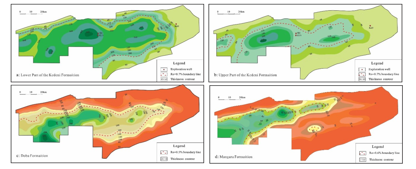
Figure 3: Map of Thickness of the Source Rocks in Different Layers
Analysis of Organic Matter Abundance
The abundance of organic matter not only reflected the hydrocarbon generation potential of source rocks, but also played an important role in evaluating the hydrocarbon generation capacity of source rocks. The evaluation indexes mainly included total organic carbon content (TOC), chloroform asphalt "A", hydrocarbon generation potential of rock pyrolysis (S1+S2), etc. [9-14]. With high total organic carbon content, the hydrocarbon generation capacity of source rocks was relatively stronger, and the oil and gas production degree was relatively greater [15-18]. The results of sample geochemaical analysis showed that the organic carbon content in the lower part of Kedeni group ranged from 1.5% to 10%, the main range ranged from 2% to 6%, and the average value was 4.8%. The closer the sample was to the center of the depression, the higher the total organic carbon content became. The range of chloroform asphalt "A" was 0.11% ~ 0.5%, the main range was 0.25% ~ 0.35%, and the average value was 0.29%. The potential hydrocarbon generation (S1+S2) of rock pyrolysis ranged from 3.2% to 11.2%, the main range ranged from 5.2% to 7.8%, and the average value was 6.5% (Figure 4). It showed that the lower part of Kedeni Formation was a good source rock. The organic carbon content in the upper part of Kedeni group ranged from 0.5% to 7%, the main interval ranged from 1% to 4%, and the average value was 3.1%. The total organic carbon content in the central and western regions of the central low bulge zone was relatively higher. The range of chloroform asphalt "A" was 0.04% ~ 0.16%, the main range was 0.07% ~ 0.1%, and the average value was 0.086%. The hydrocarbon generation potential (S1+S2) of rock pyrolysis ranged from 1.6% to 7.8%, the main range ranged from 3.2% to 5.4%, and the average value was 4.1% (Figure 4). It reflected that the upper part of Kedeni Formation was medium to good source rock.
The total organic carbon content of the source rocks of the Doba Formation ranged from 0.2% to 4%, with an average of 2.6%. The western part of the study area near the center of the depression was an area with high total organic carbon content. The range of chloroform asphalt "A" was 0.01% ~ 0.08%, with an average value of 0.05%. The hydrocarbon generation potential (S1+S2) of rock pyrolysis ranged from 1.2% to 5.7%, with an average value of 3.2% (Figure 4). The comprehensive evaluation was poor - medium source rock. The analysis of source rock samples of the Mangara Formation was mainly concentrated in the upper member, where the total organic carbon content ranged from 1.5% to 6%, the main interval ranged from 2.4% to 5.6%, and the average value was 4.5%. The total organic carbon content was relatively higher in the western central depression and in the Kibea and Kedeni sags in the eastern of the basin. The range of chloroform asphalt "A" was 0.12% ~ 0.45%, the main range was 0.28% ~ 0.36%, and the average value was 0.31%. The hydrocarbon generation potential (S1+S2) of rock pyrolysis ranged from 2.8% to 10.6%, and the main range ranged from 5.3% to 7.1%, with an average value of 6.1% (Figure 4). The upper member of Mangara Formation was considered to be a good source rock.
Analysis of Organic MatterType
According to the chart of the relationship between the pyrolytic hydrogen index HI and oxygen index OI of the source rock samples analyzed by geochemistry, 156 of the 178 samples in the lower part of Kedeni group in the study area were type I organic matter, 15 samples were type II1 organic matter and 7 samples were type II2 organic matter, accounting for 87.6%, 8.4% and 4% respectively. Among the 112 samples in the upper part of Kedeni group, 89 samples were type I organic matter, 17 samples were type were type II1 organic matter, and 6 samples were type II2 organic matter,accounting for 79.5%, 15.2% and 5.3%, respectively (Figure 5). In summary, the organic matter types of the source rocks in Kedeni Formation were mainly type I, and type II was occasionally seen. It reflected that the water body of the lake basin during the sedimentation period of Kedeni Formation was deep as a whole, and the parent material of the source rock was mainly algae and lower plankton, which had strong oil-generating capacity and great potential.
Among 125 source rock samples in Doba Formation, 21 samples were type I organic matter, 52 samples were type I organic matter, 44 samples were type II2 organic matter, and 8 samples were type III organic matter, accounting for 16.8%, 41.6%, 35.2% and 6.4%, respectively (Figure 5). The organic matter types of the source rocks in the Doba Formation were mainly type II, and type I and type III were occasionally seen, which reflected that the water body of the lake basin during the deposition period of the Doba Formation was relatively shallow, and the parent material of the source rocks was mainly plankton and higher animals, and the oil generation capacity was medium. Among 47 samples in the upper part of the Mangara Formation revealed by drilling, 34 samples were type I organic matter, I1 samples were type II organic matter, and 2 samples were type II2 organic matter, accounting for 72.3%, 23.4% and 4.3%, respectively (Figure 5). The analysis of the samples showed that the organic matter types of the source rocks in the upper part of Mangara Formation were mainly type I, and type II was occasionally seen. It reflected that the sedimentary environment of Mangara Formation was basically similar to that of Kedeni Formation in the late sedimentary period. The water in the basin depression area was deeper, and the weak hydrodynamic sedimentary environment was dominant in the lake basin area as a whole. The source rock had strong hydrocarbon generation capacity.

Figure 4: Analysis Profiles Map of Organic Matter Abundance in Source Rocks of Different Layers

Figure 5: Classification of Organic Matter Types in Source Rocks
Analysis of Organic Matter Maturity
According to the pyrolysis peak temperature analysis of the source rock samples, the maturity Ro of the source rock in Kedeni Formation ranged from 0.5% to 1.5%, and the main range was from 0.7% to 1.2%, which belonged to the mature to high mature stage dominated by oil generation. In the central and western parts of the study area, near the depositional center of the depression (near the K8 and K13 Wells), the maturity of organic matter reached a high maturity stage, and the source rocks were dominated by gas. In the eastern margin of the study area, the local source rocks near the KE5 well area were immature (Figures 3a,3b). The maturity of organic matter in the Doba Formation ranged from 0.5% to 0.8%, which belonged to the low ripening to maturity stage and was dominated by low ripening. The maturity of organic matter near the center of the depression was higher, and the maturity of organic matter in the plane was gradually lower around the center of the depression (Figure 3c). The maturity of organic matter in the Mangara Formation ranged from 0.6% to 1.6%, and there were two main ranges. In the central and eastern parts of the study area, the maturity of organic matter in the Mangara Formation ranged from 0.6% to 1.0%, and the source rocks were mainly in the mature stage of oil generation. Near the central area of the depression, the maturity of organic matter ranged from 1.0% to 1.6%, and the source rocks belonged to the mature to over-mature stage (Figure 3d). This also reflected that the maturity of source rocks in the eastern of Doseo Basin was greatly influenced by the paleodepositional center.
Reservoir Characteristics
Different sedimentary environments and sedimentary facies zones controlled the distribution of favorable reservoir sand bodies [19- 21]. The drilling data showed that three sets of favorable reservoirs were mainly developed in the eastern of Doseo Basin in the Lower Cretaceous: Doba Formation, Kedeni Formation and upper Mangara Formation. The lithology was mainly delta front sheet sandstone and shoreline shallow lake sandstone.
Analysis of Sedimentary Model
The Doseo basin had undergone three tectonic evolution stages, namely, fault-depression period, fault-depression transition period and depression period, and the provenance mainly came from the north, east and south of the basin. Near sediment source fan delta deposits were mainly developed in the northern steep slope zone of the basin, and river delta deposits were mainly developed in the eastern and southern parts of the basin, gradually extending to the interior of the basin, shallow lake and semi-deep lake facies deposits were developed. Through the analysis of single well facies and well logging facies, combined with seismic facies and seismic attributes, it was concluded that Doseo Basin had been in the early extensional fault depression stage during the depositional period of Mangara Formation, dominated by the tectonic pattern of uplift and depression, the basin sediments were mainly filled and replenished, and the northern steep slope zone was close to the sediment provenance, and fan delta sediments were developed. In the eastern of the basin, the structure was high, and the river and delta facies were mainly developed. In the southern gentle slope zone, affected by the gentle slope, the sediment transport distance was relatively long, and river alluvial plain and braided river delta facies were mainly developed and alluvial fan developed near the provenance (Fig. 6a). During the sedimentary period of Kedeni Formation, the basin entered the fault-depression transition stage, and the overall fault activity was weakened, dominated by oblique stretching and strike-slip extension of boundary faults. The northern steep slope zone inherited the narrow fan delta deposit, the facies towards the depression changed into shoreline shallow lake, semi-deep - deep lake facies, and the sublacustrine fan facies developed locally in the deep lake area. Braided river delta deposits along the long axis continued to develop in the eastern and southern gentle slope zones of the basin (Figure 6b). During the depositional period of Doba Formation, the basin entered the depression period, the fault activity was further weakened, and the sedimentary characteristics of Kedeni Formation were basically inherited as a whole. The terrain was further flattened,and the depositional center was mainly located in the middle of the depression. Affected by slow deposition in depression, the sedimentary range of fan delta in the northern steep slope zone had slightly increased, the sedimentary range of lake facies continued to expand and braided river deltas in the eastern and southern gentle slopes of the basin reduced range (Figure 6c).
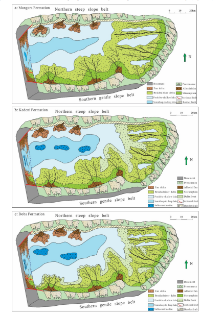
Figure 6: Sedimentary Model Maps of Different Layers in the Eastern of Doseo Basin
Analysis of Reservoir Physical Property
The sedimentary environment and sedimentary model not only controlled the shape and spatial and temporal distribution of the sand body after deposition, but also controlled the diagenesis of the reservoir rock, and then determined the composition of the clastic particles in the reservoir and the physical characteristics such as porosity and permeability [22-24]. The favorable reservoirs in the eastern of Doseo Basin were mainly braided river delta front sandstone and shoreline shallow lake sandstone, and the physical properties of the reservoirs were obviously controlled by sedimentary models. Through the statistical analysis of the pore and permeability crossplot of nearly 40 wells, it could be seen that there was a good correlation between the porosity and permeability of the reservoir in the eastern of Doseo Basin, and the reservoir characteristics were generally porous. The lower limit of effective porosity of reservoir physical properties was 10%, the porosity was mostly distributed from 12% to 28%, and the average porosity was 19.26%. The lower limit of effective permeability was 10mD, the permeability was mostly distributed between 50 and 2000mD, and the average permeability was 520mD, which belonged to the medium-porosity and medium-high permeability reservoir as a whole. Among them, the porosity range of the delta sandstone reservoir in Kedeni Formation was from 15% to 30%, with an average porosity of 22.6% the permeability ranged mainly from 120 to 2520mD, with an average permeability of 632mD; the porosity range of the shoreline shallow lake sandstone reservoir in Kedeni Formation was from 10% to 22%, with an average porosity of 14.2%, the permeability ranged mainly from 50 to 2160mD, with an average permeability of 384mD (Figure 7), which belonged to the medium-porosity and medium-permeability reservoir. As secondary reservoirs, the lower part of Doba Formation and the upper part of Mangara Formation were differ greatly in physical properties. The lower part of Doba Formation had relatively weak diagenesis and better reservoir physical properties due to shallow burial depth (less than 2000m). The porosity range of the delta sandstone reservoir in Doba Formation was from 16% to 36%, with an average porosity of 24.2%, the permeability range was mainly from 260 to 3200mD, and the average permeability was 1680mD, the porosity range of the shoreline shallow lake sandstone reservoir in Kedeni Formation was from 12% to 26%, with an average porosity of 18.6 the permeability ranged mainly from 160 to 2660mD, with an average permeability of 740mD (Figure 7), which belonged to the medium- high porosity and medium-high permeability reservoir. The upper member of Mangara Formation was buried deep (mostly more than 2700m), diagenesis was relatively strong, the reservoir was mainly delta sandstone and the physical property was relatively poor, the porosity range was mainly from 10% to 22%, and the average porosity was 14.15%. The permeability ranged mainly from 30 to 1250mD, with an average permeability of 112mD (Figure 7), and belonged to medium-low porosity and medium-low permeability reservoirs.

Figure 7: Relationship Between Porosity and Permeability of Different Layers in the Eastern of Doseo Basin
Analysis of Pore Structure Characteristics
Affected by the sedimentary environment and sedimentary model, the pore structure characteristics of the reservoir in the study area varied greatly, and the pore structure and types were different in different regions. Because the northern steep slope zone was close to the boundary fault of Doseo Basin, the characteristics of sedimentary rapid accumulation which was close to the sediment provenance were obvious. The reservoir sandstone was dominated by lithic feldspar sandstone, the rocks contained high content of feldspar, quartz and volcanic cuttings, high content of matrix, poor particle sorting, mainly angular and sub-angular (Figure 8a), and the reservoir quality was poor. The porosity and permeability were both low, and the reservoir space was dominated by intergranular dissolved pores (Figure 8b), followed by intragranular dissolved pores, with occasional residual intergranular pores and local micro- fractures. It was close to the depositional center of the central depression of the basin, due to a certain transport distance, the reservoir physical properties were relatively good, the sand particle sorting and roundness were relatively good, and the pore structure was dominated by intergranular dissolved pores and intergranular pores. The central low bulge zone was close to the eastern part of the basin, and its provenance mainly came from the eastern and southern parts of the basin. The sand body was the product of the long-distance transport of the shallow lake sandstone and braided river delta sandstone, and the sorting and grinding degree were good, and the structural and compositional maturity were high. The reservoir sandstone was dominated by arkose and subarkose, the content of complex base in arkose was about 20% ~ 22%, and the composition of complex base was mainly chlorite clay complex base, which was rounded in a secondary angular and subcircular shape, and the sorting was medium. The subarkose was dominated by potassium feldspar, and the interstitials consist of hybrid base and cement, the hybrid base was dominated by kaolin clay hybrid base, and the cement was mainly the secondary enlarged filling pores of quartz particles, which were rounded in a secondary angle- round shape and well sorted. The pore structure was dominated by primary intergranular pores, followed by intergranular dissolve pores and intra granular pores, and occasionally micro-cracks. The southern slope zone was close to the southern provenance area of the basin, and the sand body was mainly braided river delta sandstone. After a certain distance of transport, the sorting and roundness were moderate, and the structure and composition were relatively mature. The reservoir sandstone was dominated by arkose and its pore structure was similar to that of the central low convex belt. The primary intergranular pores and dissolved intergranular pores were the main porosity types, followed by the intergranular pores and dissolved pores in the hybrid base, and micro-cracks and macro-cracks were found locally (Figure 9).


Qtz: quartz, Fs: feldspar, Kfs: K-feldspar, Ab: albite, Ill: illite, mp: mold pore, indp: inner pore of dissolved particle, igdp: intergranular pore of dissolved particale
Figure 8: Microscopic Analysis of Sandstone Flakes in the Eastern of Doseo Basin
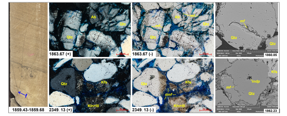
Qtz: quartz, Kfs: K-feldspar, Ab: albite, Kln: kaolinite, Ill: illite, indp: inner pore of dissolved particle, f: Fracture, mf: Microfracture, dmf: dissolved microfracture
Figure 9: Microscopic Analysis of Sandstone Fracture Flakes in the Eastern of Doseo Basin
Reservoir and Cap Combination
A good relationship between sand and mudstone was the necessary and sufficient condition for the formation of effective reservoir and cap combination, and it was also one of the necessary conditions for hydrocarbon migration and accumulation [25]. In the eastern of Doseo Basin, several sets of favorable reservoirs of Lower Cretaceous delta front facies and shore-shallow lacustrine sandstone were developed, and the cover layer was dominated by pre-delta mudstone and semi-deep lacustrine mudstone overlying favorable reservoir.
The oil and gas discovery of the Doba formation in the study area was mainly located in the overlying sandstone strata of the lower mudstone development section, and was only developed in the northern steep slope zone and the western central low bulge zone due to the influence of tectonic evolution and sedimentary environment. The whole reservoir of Doba formation had good physical property, mainly with medium-high porosity and medium-high permeability. The thickness of mudstone deposits in the Doba Formation varied greatly, mainly between 2m and 20m. The maximum thickness of mudstone single layer near the center of the basin depression was 30m, and the thickness of local effective mudstone single layer was about 5m to 15m, which could be used as an effective cap layer for oil and gas accumulation, mainly developing in the western part of the study area. The proximal reservoir or oil and gas migrated laterally along the fault to the favorable reservoir and were blocked by the local overlying layer to form the lower generated and upper stored reservoir.
Kedeni Formation was the main oil and gas reservoir in the study area. Influenced by tectonic evolution activities, the sedimentary thickness of Kedeni Formation was large, mainly sand-mudstone interbedded deposits. The sandstone had good physical properties and was dominated by medium porosity and medium permeability as a whole, and the thickness of single layer of mudstone varied greatly. The thickness of single layer of mudstone in the upper part of this group was mainly 8 ~ 15m, and the thickness of single layer of mudstone in the lower part was relatively large, mainly 20 ~ 40m, and the maximum thickness of single layer could reach 62m. The lower part of Kedeni Formation had a regional dark mudstone with a large single layer thickness, which could be used as a regional cap layer, while the upper part had a relatively small single layer thickness, which could be used as a local cap layer. Near the edge of the basin, the Kedeni Formation could still develop a stable mudstone layer, although the thickness was thin, but it could still be effectively capped. This group of mudstone not only could be used as an effective cap layer, but also was the main source rock in the basin. The sedimentary period of this group was the fault-depression transition period of the basin, and the faults were relatively developed, which provided a favorable channel for oil and gas migration. In the favorable area of reservoir and cap combination matching, lower generated and upper stored and self-generated and self-stored types oil and gas reservoirs could be formed, and oil and gas discovered of several exploration wells also confirmed that these two types of oil and gas reservoirs were developed in this group.
The oil and gas discovery of Mangara Formation in the study area was mainly from the upper part of this formation. The oil and gas in the upper part of the formation was found from the thick mudstone of the overlying Kedeni Formation, and the resulting oil and gas migrated to the favorable sandstones of Mangara Formation as a result of the influence of the thick mudstone cover. Due to the large deposition thickness of the Mangara Formation, most exploration wells were drilled only to the upper part of the formation. From the reflection characteristics analysis of seismic data, it could be seen that the middle and lower part of the Mangara Formation developed strong reflection seismic wave resistance and reflection characteristics, which was presumed to be fine-grained sediments, which may have the conditions for oil and gas generation. Due to the deep burial of the Mangara Formation, it was easy to form self- generated and self-stored oil and gas reservoirs.
Analysis of Exploration Potential
The overall exploration degree of the eastern of Doseo Basin was relatively low, the exploration work was mainly concentrated in the central low bulge zone, and several oil-bearing structures had been found. Based on the above analysis of source rocks, reservoirs and reservoir-cap combinations in the eastern of Doseo Basin, it was concluded that this area had good source rock conditions, multiple sets of favorable reservoir groups, regional cap beds and local cap beds, and good local oil and gas accumulation conditions. Although many oil and gas discoveries had been made, the types of oil and gas reservoirs were all structural reservoirs, while no oil and gas breakthroughs had been made in lithologic oil-gas reservoirs, stratigraphic oil-gas reservoirs and the deep reservoirs in Mangara Formation. From the analysis of hydrocarbon accumulation conditions, the geological conditions of these reservoirs are available in the study area [26-31]. Therefore, the eastern of Doseo Basin still had great potential for oil and gas exploration.
lithologic Reservoirs Analysis
Four stages of faults and two stages of inversion were mainly developed in the eastern of Doseo Basin which provided a good channel for oil and gas migration, but also brought great risks for oil and gas preservation. The Kedeni Formation was deposited in the fault-depression period of the basin and developed the second phase of faults. The main migration channel of oil and gas was lateral migration and accumulation along faults. Sandstone updip pitch-out reservoirs were easily formed when sandstone pinnacle- outs were encountered near faults, and Sandstone updip pitch-out reservoirs were developed in the northern steep slope belt and the central low bulge belt near the depression areas on both sides. The sedimentary facies of Kedeni Formation were mainly braided river delta deposits near the subsidence center of the basin and Kedeni sag and Kibea sag. Mudstone and lacustrine mudstone were relatively developed in the front of the delta front, and sandstone with good reservoir physical properties was subjected to form turbidite by gravity flow or surrounded by mudstone deposits nearby, forming sandstone lenticular hydrocarbon reservoirs (Figure 10). The mudstone in the lower part of Doba Formation was also relatively developed near the depocenter and the depression area of the basin, and these two types of hydrocarbon reservoirs may also be formed. At present, these two types of hydrocarbon reservoirs have still not been found in the eastern of Doseo Basin, which may be the key direction and field of oil and gas exploration in the later period of this area.
Stratigraphic Reservoirs Analysis
In the eastern of Doseo Basin, four sets of unconformities were identified from the bottom to the top by seismic profiles under the influence of multi-stage tectonic movements. When the basin was formed, the basement extensional fault caused local denudation of the top boundary deposits, resulting in the formation of the basement top surface unconformity. The Lower Cretaceous Mangara Formation was a fault filling period in which the early sediments of the basin were filled and replenished. The deposition time was long and the thickness was large. The top surface of the Mangara Formation suffered different degrees of denudation and formed the top surface unconformity. If the source rocks were well developed at the bottom of the Mangara Formation, basement buried hill unconformity hydrocarbon reservoirs could be formed at the top boundary of the base with effective cover layer in the overlying strata. It has been analyzed and described in the previous that the best dark hydrocarbon source rock in the developing basin at the bottom of Kedeni Formation had great hydrocarbon generation potential, unconformity surface was developed at the top boundary of Mangara Formation, and stratigraphic unconformity hydrocarbon reservoir may be formed at the top of Mangara Formation in the undeveloped fault area (Figure 10). At present, due to the low degree of overall exploration, no unconformity hydrocarbon reservoirs have been found in the eastern of Doseo Basin, which could be explored as one of the exploration fields in the future.
Deep Reservoirs in Mangara Formation Analysis
The Mangara Formation has a long deposition time of more than 20Ma and a large deposition thickness of 2000 ~ 3000m in general, with a thickness of more than 3500m in the study area which provided good conditions for the generation of oil and gas. According to the analysis of basin tectonic evolution, the late tectonic movement mainly occurred in the Late Cretaceous and had little influence on the sedimentary strata in Mangara Formation of the early Cretaceous. Therefore, the internal fault development of the Mangara Formation was relatively small, and the fault activity period was relatively short, which had little influence on the oil and gas reservoirs formed by the early sedimentation of the basin. It was also mentioned in the above analysis that a set of strong seismic reflection axes developed in the middle and lower part of the Mangara Formation, which was presumed to be a favorable source rock. During the sedimentary period of the Mangara Formation, coarse-grained sediments were the main deposits, which should be a well-developed reservoir group. Therefore, the Mangara Formation has favorable source rocks and reservoirs for oil and gas accumulation, and was expected to become a potential field for subsequent exploration in the eastern of Doseo Basin (Figure 10) [32].
Figure 10: Schematic Diagram of Hydrocarbon Accumulation Pattern in the Eastern of Doseo Basin
Conclusion
(1) Three sets of favorable source rocks were developed in the eastern of Doseo Basin in Chad, among which the lower Cretaceous Kedeni Formation lacustrine dark mudstone was the main source rock, which had good organic matter type, high maturity, large thickness, wide distribution and great hydrocarbon generation potential. The dark mudstones of the Lower Cretaceous Mangara and Doba Formations were the secondary source rocks.
(2) Under the influence of sedimentary environment, several sets of favorable reservoirs developed in the Lower Cretaceous of Doseo Basin, and the regional and local cap layers of Kedeni Formation were developed, and the reservoir and cap combination matching relationship was good, Kedeni Formaiton was the main hydrocarbon-bearing layer in this area. Doba Formation and Mangara formation were affected by local cap and favorable reservoir development, and locally developed favorable traps.
(3) Lithologic reservoirs, stratigraphic reservoirs and deep reservoirs of Mangara formation may be the main replacement areas for future oil and gas exploration in the eastern of Doseo Basin.
References
- Zhang, Q. L., Hou, G. T., & Pan, X. H. (2018). Dynamic mechanism of rift systems in West and Central Africa. Journal of Geomechanics, 24(2), 169-176.
- KONGLingwu, Z. S., HANWenming, Z. H. A. O., ZHAO,J., & YU, Y. (2019). Discussion on the structural features and formation mechanism of strike-slip pull-apart basin: a case study in the Doseo Basin, Central Africa. Geological Journal of China Universities, 25(5), 722.
- Weifu, L. I. U. (2016). Cretaceous sequence stratigraphy and depositiona filsystem in Doseo Basin Chad [J]. Journal of Central Sout h University (Science and Technology), 47(6), 1982-1989.
- Cheng, D., Dou, L., Wang, J., Zhang, X., Hu, J., & Shi, Y. (2021). Source rocks evaluation and oil source correlation of the Doseo basin, Chad. Acta Geol. Sin, 95(11).
- Lirong, D., Kunye, X., Yebo, D. U., Li, W. A. N. G., Zhang,X., Cheng, D., & Ying, H. (2022). Exploration discovery and hydrocarbon accumulation characteristics of the Doseo strike- slip and inverted basin, Chad. Petroleum Exploration and Development, 49(2), 247-256.
- Zhang, G., Yu, Z., Chen, Z., Zhang, D. Q., Wen, Z. X., Huang,T. F., ... & Zhao, J. (2018). Tectonic evolution and hydrocarbon distribution in African basins. Earth Science Frontiers, 25(2), 1-14.
- Caili, L., & Yang, Z. (2018). Differences in tectonic evolution and mechanisms of tectonic dynamics of rift basins in Central Africa. Journal of Southwest Petroleum University (Sci-ence & Technology Edition), 40(6), 23-34.
- Hong, M., Yebo, D., Li, W. Zhaoming, W., Lin, W., Jie, H.,Huahua, G., Yuhua, W., Simin, G., & Haiyan, Z. (2024). Structural evolution and hydrocarbon accumulation conditions of the strike-slip pull-out Basin in the Central African rift system: A case study of the Doseo Basin in Chad. Journal of Oil and Gas Research Reviews. 4(1): 1-12.
- Tao, W., Yang, W., Shengqiang, Y., Fengjun, M., Jiguo, L., Xiaowen, G., & Rui, Y. (2023). Simulation of burial history, thermal evolution history, and hydrocarbon generation history of the Upper Cretaceous Yogou Formation source rocks in the Termit Basin. Bulletin of Geological Science and Technology, 42(6), 151-161.
- Wang, Q., Zou, H., Zhou, X., Tian, D., Teng, C., Jia, X., & Liu, J. (2017). Gas potential of source rocks and origin of natural gases in Bohai Sea. Geological Journal of China Universities, 23(2), 304-314.
- Xin, W. A. N. G., Zheng, L. I., Rifang, Z. H. U., Ping, L.,Ru, W., Zicheng, N., & Da, L. (2023). Study on hydrocarbon generation characteristics of Carboniferous-Permian coal- measure source rocks in Huanghua Depression, Bohai Bay Basin. Special Oil & Gas Reservoirs, 30(4), 19.
- Wang, G., Li, Y., Wang, Y., & Xing, X. (2024). Geochemical characteristics and sedimentary environment of Chang7 sourcerocks, Southern Ordos Basin. Journal of China University of Petroleum (Edition of Natural Science), 48(1), 91-103.
- Zicheng, N. I. U., Yongshi, W. A. N. G., Xuejun, W. A. N.G., Xuejun, Z. H. A. N. G., Xiuhong, W. A. N. G., Dongmei,H. A. N., ... & Juan, W. A. N. G. (2022). Hydrocarbon Generation Potential of Pre-Paleogene Source Rocks in the Jiyang Depression# br. Geological Journal of China Universities, 28(1), 73.
- Dujie, H., Shanwen, Z., Jianxin, X., Linye, Z., Haiquan, Z., & Shunguo, C. (2008). The excellent source rocks and accumulation of stratigraphic and lithologic traps in the Jiyang Depression, Bohai Bay Basin. China, 15(2), 137-146.
- Xing, K. E., Qingfang, Z. H. A. O., Piao, W. U., Chuansheng,Y. A. N. G., Jing, L. I. A. O., & Jianming, G. O. N. G. (2023).Characteristics and Evaluation of Cretaceous Source Rocks in the Northeastern Jiaolai Basin. Geoscience, 37(05), 1358.
- Wenjun, W., Liwu, L., Zuodong, W., Ting, Z., Yin, F., & Zhenhua, Z. (2023). Geochemical characteristics and oil source analysis of the Middle Jurassic Yaojie Formation source rocks in Minhe Basin, China. Journal of Chengdu University of Technology (Science & Technology Edition), 50(2), 296-137.
- Xiongbing, Y. A. N. G., Hongyu, W. A. N. G., Yushan, S. U., & Chao, G. U. A. N. (2023). Source Rock Characteristics and Its Accumulation Contribution in the Lower Congo Basin, South Atlantic. Geoscience, 37(05), 1369.
- Yan, L., Xiuqi, Z., Xiaoyu, L., Yang, C., Zhenxing, T., Bin, W.,... & Zhilong, H. (2013). Characteristics and validity analysis of hydrocarbon source rocks of Upper Paleozoic in Songliao Basin. Journal of Earth Sciences and Environment, 35(4), 39- 48.
- Xiao, M., Desheng, H., Jie, W., Liyuan, G., Zhixuan, L., Yingde, J., & Ye, Z. (2023). Development characteristics and accumulation model of sublacustrine fans of the first member of Eocene Liushagang Formation in Weixinan Sag, Beibuwan Basin. Lithologic Reservoirs, 35(4), 137-144.
- Zongbao, L., Xue, L., Ronghua, Z., Huaqing, L., Zhanlong, Y., & Song, C. (2022). Sedimentary characteristics and models of shallow water delta front subfacies reservoirs: A case study of Sapugao oil layer in north-II block of Sabei oilfield, Daqing placanticline. Lithologic Reservoirs, 34(1), 1-13.
- Bizhu, H., Cunli, J., Ruohan, L., Zicheng, C., Zhihui, C., Mingjie, L., Xiaorui, Y., … & Zhenyu, L. (2023). The paleotectonic and paleogeography reconstructions of the Tarim Basin in the Neoproterozoic and prediction of favorable deep source rock areas. Earth Science Frontiers, 30(4), 19-42.
- Chunjuan, Z., Shujuan, X., Honggang, C., Chunmeng, D., & Deyong, D. (2024). Sedimentary facies types and evolution models of the Shahezi formation in the Xujiaweizi fault depression, Songliao Basin. Acta Sedimentologica Sinica, 42(4), 1460-1478.
- Bintao, C., Lun, M., Liang H., Zhongsheng, S., Wenzhu,P., Luo, X., Lei, W., … & Yanjun, Z. (2024). Sedimentary evolution and controlling factors of fan delta and slump fan complex deposition in a steep slope belt of a faulted basin: A case study from the Cretaceous deposits of the A sag in Melut Basin, Central Africa. Acta Sedimentologica Sinica, 42(3), 1058-1072.
- Tianhai, W., Duonian, X., Tao, W., Xin, G., Zaibo, X., & Huifei,T. (2024). Sedimentary facies distribution characteristics and sedimentary model of Triassic Baikouquan Formation in Shawan Sag, Junggar Basin. Lithologic Reservoirs, 36(1), 98-110.
- Kuan, Z., Guosheng, X., Jing, Y., Feilong, W., & Haoran,L. (2021). Hydrocarbon accumulation conditions and accumulation models in the central horst zone of Qingdong Sag, south Bohai Sea, China. Journal of Chengdu University of Technology (Science & Technology Edition), 48(2), 186- 194.
- Xianzheng, Z., Lihong, Z., Xiugang, P., Fengming, J., Wenya, J., Dunqing, X., Wenzhong, H., & Zhannan, S. (2018). Development and exploration practice of the concept of hydrocarbon accumulation in rifted-basin troughs: A case study of Paleogene Kongdian Formation in Cangdong sag, Bohai Bay Basin. Petroleum Exploration and Development, 45(6), 1166-1176.
- Xianzheng, Z., Fengming, J., Yubang, L., Quan, W., Lihong, Z., Yanfang, L., Xiugang, P., & Wei, W. (2016). Slope belt types and hydrocarbon migration and accumulation mechanisms in rift basins. Petroleum exploration and development, 43(6), 915-924.
- Guoliang, H., Hongjun, W., Houqin, Z., Zhenhua, B., & Wenwen, W. (2023). Hydrocarbon accumulation conditions and favorable zones of litho-logic reservoirs of Miocene Gumai formation in block J, South Sumatra Basin. -Lithologic Reservoirs, 35(6), 138-146.
- Feng, M., Wenzhu, P., Wenguang, Z., Bin, Z., Yanjun, Z., Luo, X., Qian, Z., & Bintao, C. (2023). Main controlling factors and hydrocarbon accumulation models of structural-lithologic reservoirs above source kitchen in rift basins in South Sudan. Lithologic Reservoirs, 35(6), 92-105.
- Lirong, D., Zhi, L., Zi, Y., Xingyang, Z., Hailiang, K., Mingjun, Z., Liangjie, Z., & Liangbo, D. (2023). Exploration progress and outlook for lithostratigraphic reservoirs of CNPC overseas. Lithologic Reservoirs, 35(6), 1-9.
- Hengxuan, L., Zhixin, W., Chengpeng, S., Zuodong, L., Tianyu, J., Yiping, S., & Ke, G. (2023). Evolution of Senegal Basin and exploration prospects of lithologic reservoirs. Lithologic Reservoirs, 35(6), 45-53.
- Hong, M., Yebo, D., Li, W. Zhaoming, W., Lin, W., Jie, H., Huahua, G., Yuhua, W., & Simin, G. (2024). Tectonic evolution of strike-slip basins in the Central African rift system and its oil control: A case study of the Doseo Basin in Chad. China Petroleum Exploration, 29(2), 83-97.