
AI and Intelligent Systems: Engineering, Medicine & Society(AIISEMS)
ISSN: 3068-9503 | DOI: 10.33140/AIISEMS


Research Article - (2025) Volume 1, Issue 1
The Social Groups and Decline of a Southwestern Clovis Network
Received Date: May 23, 2025 / Accepted Date: Jun 25, 2025 / Published Date: Jun 30, 2025
Copyright: ©Ã?©2025 M.A. Wendorf. This is an open-access article distributed under the terms of the Creative Commons Attribution License, which permits unrestricted use, distribution, and reproduction in any medium, provided the original author and source are credited.
Citation: Wendorf, M. A. (2025). The Social Groups and Decline of a Southwestern Clovis Network. AI Intell Sys Eng Med Society, 1(1), 01-14.
Abstract
Background: The Clovis technocomplex of North America is reminiscent of the Upper Paleolithic industries of Eurasia, but has notable differences [1]. Clovis may have lasted from ca. 13,050 to 12,750 years ago, though some Clovis manifestations may date from about 13,500 years ago [2,3]. Clovis is particularly well known from Southeastern Arizona where a number of Mammoth kill sites have been found including Murray Springs, Lehner Ranch, and Naco [4-7].
Objective: The objective of this research was to map a network that extended across southeastern Arizona, Southwestern New Mexico, and northern Sonora, Mexico and to show how this network responded to environmental change.
Methods: Network nodes were Clovis assemblages or stone quarry sites that had been visited by Clovis and links were identified by lithic raw materials that were shared between the network nodes. Two separate network maps were drawn and compared.
Results: A new Clovis site was identified near Willcox, Arizona. Twenty Clovis assemblages were identified and designated network nodes. The network showed evidence of the foraging party, seasonal aggregation, and periodic aggregation social grouping layers of a Clovis band. The two network maps showed the network during event time 1 and event time 2 respectively. The network evidently declined from the west during event time 2 due to a drought in the Sonoran Desert region.
Conclusions: A Clovis band in Southeastern Arizona and adjacent regions of the Southwest evidently was supported by a regional social network that may have been a small world. This network evidently was robust to the loss of nodes and links on its western side.
Keywords
Hunter-Gatherers, Information, Errors, Robustness
Introduction
The Clovis techno-complex of North America is reminiscent of the Upper Paleolithic industries of Eurasia, but has notable differences [1]. Clovis populations were hunter-gatherers whose tool kit included distinctive “fluted” bifacial points (Figure 1), bifaces (Figure 1), preforms, spurred end scrapers, side scrapers, flake knives, backed blades, gravers, limaces and occasional burins (Figure 1) plus a variety of ivory and bone tools [8-13]. Clovis may have lasted from ca. 13,050 to 12,750 years ago, though some Clovis manifestations may date from about 13,500 years ago, and was coincident with an interval of environmental change and the extinction of large mammals such as mammoth, mastodon, camel, and horse [2-4,14-16].
The Clovis record in southeastern Arizona is particularly noteworthy. The San Pedro Valley has several renowned Clovis sites including Murray Springs, Lehner Ranch, and Naco [4-7]. The stratigraphy at the Murray Springs site indicates that there were at least two and possibly four Clovis visits to the site during a brief period [17]. Just prior to the first clear Clovis visit to Murray Springs, the multiple bison kill in Area 4/5, the water table dropped during a drought such that the streambed was saturated with water but there was no stream flow [17]. The Area 4/5 Clovis occupation included 11 bison with associated Clovis projectile points, butchering tools, at least two hearths, and flake concentrations. An adjacent campsite in Areas 6 and 7 had additional Clovis points, tools, and flake concentrations and was firmly associated with the bison kill by artifact retrofits [4,18].
By the time of the last Clovis visit to Murray Springs, the mammoth/bison kill in Area 3, animals disrupted the streambed digging for water in the continuing drought [17]. This Clovis occupation included Clovis projectile points, butchering tools, a carved mammoth bone shaft straightener, a fragment of worked bone, and an abundance of debitage from flint knapping [5,18]. The presence of a mammoth bone fragment and a mammoth tooth fragment in the camp area suggests that the adjacent campsite also was associated with the mammoth kill in Area 3 [19]. It is likely that Clovis populations in the San Pedro Valley and the Basin and Range area were organized as multifamily bands of 50 to 100 individuals [18]. Almost every aspect of a band-level cultural system is involved in some way with the acquisition, storage, circulation, and use of information and networks in turn play a crucial role in the circulation or sharing of information [20,21]. This paper presents a study of a regional social network of a Clovis band in the San Pedro Valley and the adjacent Basin and Range area.
Methods
A network can be viewed as a catalogue of a system’s components, called nodes, and the direct interactions between them, called links [22]. The number of links a node has to other nodes is known as its degree, denoted k [22]. In this study network nodes were Clovis assemblages or lithic quarry locations and the links connecting the nodes were denoted by shared raw materials. The use of shared raw materials as a proxy for interactions between nodes recognizes that knowledge and ideas are passed between hunter-gatherers when physical resources (such as raw materials) are exchanged and is consistent with the methods of previous studies of Clovis networks [23-26]. The raw materials in this study 5 were almost exclusively identified by visual inspection. As noted by Buchanan and others and Slade, there is some subjectivity in this approach [26,27]. Raw material data was drawn from published identifications of stone type (chert, basalt, etc.) color (gray, reddish brown, etc.), and additional attributes such as “spotted” or “translucent” [5,28].
Obtaining the Clovis Assemblages
The Clovis assemblages were obtained from either controlled excavations of Clovis sites or from surface collections that had at least one diagnostic Clovis fluted point for which the provenience and raw material were known. These assemblages were obtained from publications and cultural resource survey reports, museum collections, the Arizona Paleoindian Projectile Point Survey, and interviews with private collectors. Pedestrian surveys also were conducted as permitted in parts of the study area, notably near the Babocomari and San Pedro Rivers, San Simon Creek, Brawley Wash, and Astin Springs. Though cautions were kept in mind the incorporation of surface collected Clovis points is consistent with previous studies of Clovis and Paleoindian settlement technology [28-32]. With two exceptions, a stage 4 biface fragment (an incomplete Clovis point) and a composite scraper/burin tool (Figure 1) that were found on the Willcox Clovis site discussed below, the only surface collected artifacts used to establish network nodes and links were diagnostic Clovis fluted points.
The St. David chalcedony and Cow Canyon obsidian sources also were included as network nodes because these locations were clearly visited by Clovis were even though they lacked diagnostic Clovis artifacts. Likely representing game that escaped their hunters and later died of their wounds, the renowned Naco and Escapule Clovis sites and the Texas Canyon Clovis point were not incorporated in the network [4,33]. More than 30 Clovis assemblages that may or may not have been contemporary have been identified in southern Arizona and adjacent areas since the 1930s [34-36]. In an effort to map network components that were roughly the same age, only the assemblages that shared raw materials with the excavated areas (either Area 4/5 or Area 3) at Murray Springs were used to designate network nodes. Though it is possible that Lehner Ranch was occupied slightly earlier than Murray Springs, the Lehner Ranch and Murray Springs Clovis sites then were mapped as roughly contemporary network nodes because they shared some raw materials [5]. The Leikem mammoth site, which shared raw material with both Lehner Ranch and Murray Springs, was connected to the Lehner Ranch mammoth kills and not the Area 4/5 bison kill at Murray Springs because the prey at Leikem was mammoth not bison [55].
Determining the Social Grouping Layers
The area encompassed by the network, reflected by link lengths, also was considered in this study. The home range of a typical hunter-gatherer population has been shown to be comprised of a hierarchy of cumulative groupings or layers that are typically but not necessarily nested [21]. Each group or layer encompasses its own range area: 1) the nuclear family layer (ca. 5 individuals); 2) the foraging party or Group 1 layer (ca. 15 individuals), 3) the seasonal aggregation or Group 2 layer (ca. 50 individuals), 4) the periodic aggregation or Group 3 layer (ca. 150 to 500 individuals), and 5) the ethnolinguistic tribe or population layer (up to ca. 1500 individuals). The radius of each layer’s range area, reflecting the total space within which individuals move, varies by biome [21].
Due to the mid latitude location of the study area and fossil pollen indicating the presence of trees typical of mid latitude forest (alder, ash, walnut and hackberry) at the Lehner site and evidence of the use of ash as firewood at Murray Springs the social grouping layers from the subarctic and mid latitude forest biome were used in this study as a guide for determining link lengths as follows: foraging party or Group 1: 9 - 42 km; seasonal aggregation or Group 2: 12 - 86 km; periodic aggregation or Group 3: 19 - 143 km; and ethnolinguistic tribe or population: 41-458 km [17,18,21]. Since the goal of this study was to map the regional social network of a Clovis band, link lengths within the maximum radii for bands, ca. 143 km, were mapped and associated nodes were designated numerically.
Links between archaeological sites and their raw material sources, which can exceed typical foraging radii were denoted with dashed lines [21]. As discussed by Pearce and Moutsiou, link lengths reflected the inhabited range areas, rather than mobility data per se [21]. Consequently, straight-line distances, which might deviate from likely Clovis residential movement distances, were mapped and compared [21]. Link lengths were determined “as the crow flies” using the distance function in Google earth.
Mapping the Network
Following the guidelines outlined above, two maps of the network were drawn. The first, labelled event time 1, showed the network during the Clovis occupation of Area 4/5 at Murray Springs, and the second, labelled event time 2, showed the network during the subsequent occupation of Area 3. Recognizing that real networks typically evolve over time through the addition and removal of links and nodes the maps of the network during event time 1 and event time 2 then were compared [22].
Results
Though no diagnostic Clovis fluted projectile points were found during the pedestrian surveys, four previously unrecorded fluted points were located through conversations with landowners and avocational archaeologists. Two of these unrecorded fluted points, both made of dark gray basalt, were reportedly found in a Clovis campsite near Big Sandy in southwestern New Mexico. The third fluted point, made from a glossy white chert, was reportedly found near Astin Springs in the far southeast corner of Arizona, and the fourth, made from an ivory chalcedony, was reportedly found west of Safford, Arizona. In addition, several artifacts in the Amerind Foundation collection from two adjacent lithic scatters (AZ CC:13:16 and AZ CC:13:18) that were found within a few meters of the “Wilcox Playa” Clovis point were identified by this project as Clovis tools: a proximal fragment of a stage 4 Clovis biface (unfinished fluted point) (Figure 1), a composite scraper/ burin (Figure 1), a spurred scraper, and an end and side scraper on a primary blade [33]. Further, two complete chert Clovis points reportedly from the town of “Wilcox” (the original spelling of the place name) were recently located by Slade in the collections of the British Museum and likely had been collected from either AZ CC:13:16 or AZ CC:13:18 when the town was known as “Wilcox” [27].
With at least one and possibly three Clovis points, an unfinished Clovis point, and other typical Clovis tools, the location of the Willcox Clovis point and the two adjacent lithic scatters were labelled the Willcox Clovis site. The spurred scraper, basal fragment of a stage 4 biface, and composite tool/burin, tools often associated with camp activities indicate that the Willcox site likely was a Clovis campsite [19]. Following review, 20 Clovis assemblages that shared raw materials with either Area 4/5 or Area 3 at Murray Springs were identified and designated network nodes (Table 1).
|
Assemblage |
Node |
DMS Coordinates |
Location |
Haynes No. |
Reference |
|
Willcox |
1 |
Lat: 32.217852 deg. Long: -109.768784 deg. |
southeast of Willcox, AZ |
No. 13 |
|
|
Sanchez |
2 |
Lat: 32.881176 deg. Long: -109.533862 deg. |
east of Safford, AZ |
No. 108 |
|
|
Big Sandy |
3 |
Lat: 32.419389 deg. Long: -108.960341 deg. |
northwest of Lordsburg,NM |
N/A |
N/A |
|
Playas |
4 |
Lat: 31.938174 deg. Long: -108.689116 deg. |
east of Animas, NM |
N/A |
|
|
Lehner Ranch |
5 |
Lat: 31.422574 deg. Long: -110.114991 deg. |
north of Palominas, AZ |
Nos. 14- 26 |
|
|
Murray Springs |
6 |
Lat: 31.57012 deg. Long: -110.179882 deg. |
east of Sierra Vista, AZ |
Nos. 37- 54 |
|
|
St. David chalcedony |
7 |
Lat: 31.885718 deg. Long: -110.252613 deg. |
west of St. David, AZ |
N/A |
|
|
Cow Canyon obsidian |
8 |
Lat: 32.937237 deg. Long: -109.096300 deg. |
northwest of Safford, AZ |
N/A |
|
|
Rising |
9 |
Lat: 31.449845 deg. Long: -109.128164 deg. |
southeast corner of AZ |
No. 36 |
|
|
Malpai |
10 |
Lat: 31.365556 deg. Long: -109.284722 deg. |
southeast corner of AZ |
No. 89 |
|
|
La Cruz |
11 |
Lat: 31.32021 deg. Long: -109.897269 deg. |
southeast of Naco, SO, Mex |
N/A |
|
|
Leikem |
12 |
Lat: 31.345804 deg. Long: -109.949815 deg. |
near Naco, AZ |
No. 31 |
|
|
Formby |
13 |
Lat: 31.999003 deg. Long: -111.21846 deg. |
southwest of Tucson, AZ |
Nos. 70- 71 |
|
|
Herring |
14 |
Lat: 32.209436 deg. Long: -111.155284 deg. |
west of Tucson, AZ |
No. 58 |
|
|
Doschka |
15 |
Lat: 32.06095 deg. Long: -110.888816 deg. |
near Sahuarita, AZ |
N/A |
|
|
Escapule point |
16 |
Lat: 31.714893 deg. Long: -110.312404 deg. |
north of Sierra Vista, AZ |
N/A |
|
|
Goodman Ranch |
17 |
Lat: 32.534362 deg. Long: -110.93504 deg. |
northwest of Tucson, AZ |
No. 94 |
|
|
Rincon |
18 |
Lat: 32.149482 deg. Long: -110.720812 deg. |
east of Tucson, AZ |
No. 85 |
|
|
Navarrete |
19 |
Lat: 31.349756 deg. Long: -109.958759 deg. |
near Naco, AZ |
No. 61 |
|
|
Ronstadt |
20 |
Lat: 32.274108 deg. Long: -110.874837 deg. |
north side of Tucson, AZ |
No. 83 |
|
Table 1: Clovis Assemblages and Raw Material Sources Mapped as Nodes in the Cochise Clovis Network

Figure 1: Clovis artifacts from network node 1, the Willcox Clovis site, in southeastern Arizona Left to right: the “Wilcox Playa” Clovis point (ivory chalcedony) redrawn from Di Peso, a “stage 4” biface fragment (brownish gray chert), and a composite scraper/burin (dark gray basalt) [33].
DMS values for additional sites mentioned in the text - Naco site: Latitude: 31.349797 deg, Longitude: -109.959316 deg; San Bernardino point: Latitude: 31.336659 deg, Longitude:-109.279856 deg; Texas Canyon point: Latitude: 32.050624 deg, Longitude: -110.078864 deg, and Astin Springs: Latitude: 31.356111 deg, Longitude: -109.261389.DMS values in column 3 for nodes -1 to -20 and for the Naco site, the San Bernardino point, and the Texas Canyon point were derived from easting and northing values in the Fluted Point Database in the Digital Archaeological Record (tDAR). DMS values for nodes 4,7,8,11 and 15 were estimated from a published description of the site location. DMS values for nodes 3 and 10 and for the Astin Springs point were estimated from a verbal description of the site location. Haynes numbers in column 4 refer to Clovis point designations in Haynes [34].
The Clovis Occupation of Area 4/5 at Murray Springs
The network as it may have appeared during event time 1, the Clovis occupation of Area 4/5 at Murray Springs, is shown in Figure 2, and the associated links and nodes are listed in Table 2. At this time the network evidently had a maximum east-west diameter of roughly 220km from node 4 (Playas) to node 16 (Formby) and a maximum north-south diameter of roughly 180km, from node 10 (Malpai) to node 8 (the Cow Canyon obsidian source). A more distant connection (ca. 500 km) to Mockingbird Gap in New Mexico, shown by shared Cow Canyon obsidian also may have been a distant connection to a larger Clovis network in western North America [5,26,37]. The minimum degree of the network would have been 1, the maximum degree 14, such that there would have been an order of magnitude difference in size between the smallest and the largest nodes.
Six of the network nodes had 1 degree (nodes 7,8,11,12,15 and 16), three nodes had 2 degrees (nodes 2, 4 and 14), three nodes had 3 degrees (nodes 3,9 and 10), three nodes had 4 degrees (nodes 13,17 and 18), one node had 5 degrees (node 1 or Willcox), one node had 8 degrees (node 5 or Lehner Ranch), and one node had 14 degrees (node 6 or Murray Springs). With numerous small nodes having one or two links coexisting with a few large hubs, the link distribution of the Cochise Clovis network was consistent with a mathematical expression called a power law [38]. Power laws have been found in networks behind the world wide web, the cell, and many other complex systems and lacking a meaningful internal scale, are considered “scale-free” [22,38,39]. Due to its hubs, which act as bridges between many small degree nodes the Cochise Clovis network also likely was a small world [22]. The distant connection to Mockingbird Gap in New Mexico noted above suggests that the network could have been a small world with a longer-distance connection, supporting the suggestion that Clovis regional social networks could have been small worlds with occasional longer-distance connections [26].
Several social grouping layers also were evident in the network at this time, though, as noted by Pierce and Moutsiou, some might not have been nested [21]. The short ca. 16 km link between node 9 (Rising) and node 10 (Malpai) on the southeastern side of the network, for example, could represent the foraging party (Group 1) layer. Clovis points found within a few kilometers of nodes 9 (Rising) and 10 (Malpai), such as the San Bernardino point and the newly reported Astin Springs point, support Clovis foraging in this area [28]. The Clovis campsite at Willcox and its links could represent a seasonal aggregation (Group 2) layer in the network. Here all of the links radiating from Willcox were within the expected range of this layer: the ca. 70 km link to node 2 (Sanchez), the ca. 80 km link to node 3 (Big Sandy), the ca. 85 km link to node 4 (Playas), the ca. 87 km link to node 5 (Lehner Ranch), and the ca. 80 km to node 6 (Murray Springs).
Seasonal foraging also is evident in the ca. 215 km round trip loop from the Willcox campsite to node 3 (Big Sandy), node 4 (Playas) and back to Willcox that roughly resembled the distance and shape of the ca. 210 km seasonal round of a Nunamiut Eskimo family [40]. The links from Willcox to node 2 (Sanchez) and to nodes 5 (Lehner Ranch) and 6 (Murray Springs) could represent remnants of additional foraging loops in the Group 2 layer at Willcox. With its clearly associated Clovis campsite, the multiple bison kill in Area 4/5 at Murray Springs could have had nested foraging party (Group 1) and periodic aggregation (Group 3) layers. The foraging party layer was evident in the ca. 17 km link to node 5 (Lehner Ranch), the ca. 40 km to node 7 (St. David chalcedony source), the ca. 40 km to node 11 (La Cruz), and the ca. 15 km to node 16 (the Escapule point). The periodic aggregation (Group 3) layer was evident in the ca. 143 km to node 2 (Sanchez), the ca. 145 km to node 3 (Big Sandy), the ca. 200 km to node 8 (Cow Canyon Source), the ca. 95 km to node 9 (Rising), ca. 85 km to node 10 (Malpai), the ca. 100 km to node 13 (Formby), the ca. 110 km to node 14 (Herring), the ca. 90 km to node 15 (Doschka), the ca. 110 km to node 17 (Goodman Ranch), and the ca. 80 km to node 18 (Rincon). (Please note: the link connecting Murray Springs to the Cow Canyon source was interpreted as an example of a link between an archaeological site and the geological source of a raw material that exceeded the typical foraging radius of its social group).
Previous estimates of Clovis demography at Murray Springs support the presence of an aggregation layer in the vicinity of the site. A large group of armed male hunters, perhaps 22 or more, may have been needed to surround and dispatch the 11 bison found in Area 4 [18]. Evidence of hide working in the associated camp in Area 6 and 7 indicates that women (and children) also were present such that perhaps 70 individuals took part in the Area 4/5 Clovis occupation of Murray Springs [19,34,41]. Since a typical band might have about 70 people it is possible that an entire (aggregated) Clovis band took part in the Area 4/5 Clovis occupation of Murray Springs [42]. Ethnographic hunter-gatherer aggregations, which typically occur when food is sufficiently concentrated are a requirement of social and biological viability 20 and function as a provision for mates, food sharing, cooperative exploitation, trade, rituals, and information sharing [43,44]. The aggregation at Murray Springs, evidently supported by the concentration of food provided by the multiple bison kill, might have served a similar role in the lifeway of the Clovis band.
|
Link |
Raw Material |
1st Node |
Cur. |
Cat. No. |
2nd Node |
Cur. |
Cat. No. |
|||
|
|
brownish gray chert |
stage biface1 |
4 |
AM |
SSV/084 |
Clovis point |
LP |
N/A |
||
|
(1,3) |
dark basalt |
gray |
scraper/burin1 |
AM |
SSV/085 |
Clovis point |
LP |
N/A |
||
|
(1,4) |
dark basalt |
gray |
scraper/burin1 |
AM |
SSV/085 |
Clovis point |
ASM |
|
||
|
(3,4) |
dark basalt |
gray |
Clovis point |
LP |
N/A |
Clovis point |
|
|
||
|
(5,1) |
brownish gray chert |
Clovis point |
ASM |
A-12675 |
stage biface1 |
4 |
AM |
SSV/084 |
||
|
(5,9) |
red jasper |
Clovis point |
ASM |
A-12686 |
Clovis point |
ASM |
|
|||
|
(5,10) |
red jasper |
Clovis point |
ASM |
A-12686 |
Clovis point1 |
|
MM |
|
||
|
|
||||||||||
|
(5,12) |
pinkish chert |
gray |
Clovis point |
ASM |
A-12680 |
Clovis point |
ASM |
A-24127 |
||
|
(5,13) |
white chert |
flake3 |
ASM |
|
Clovis point |
Pr.C. |
N/A |
|||
|
(5,14) |
red jasper |
Clovis point |
ASM |
A-12686 |
Clovis point |
ASM |
|
|||
|
(5,17) |
white chert |
flake3 |
ASM |
|
Clovis point |
PCC |
PCC 4358 |
|||
|
(5,18) |
white chert |
flake3 |
ASM |
|
Clovis point |
WAC |
SAGU461 |
|||
|
(6,1) |
dark gray basalt brownish gray chert |
cluster A4-1d area 4 flakes |
ASM ASM |
|
scraper/burin1 stage 4 biface1 |
AM AM |
SSV/085 SSV/084 |
|||
|
(6,2) |
brownish gray chert |
area 4 flakes |
ASM |
|
Clovis point |
LP |
N/A |
|||
|
(6,3) |
dark basalt |
gray |
cluster A4-1d |
ASM |
|
Clovis point |
LP |
N/A |
||
|
(6,5) |
pinkish chert |
gray |
Clovis point |
ASM |
A-33114 |
Clovis point |
ASM |
A-12685 |
||
|
(6,7) |
St. David chalcedony |
cluster A4-1a |
ASM |
|
N/A |
|
|
|
(6,8) |
Cow Canyon obsidian |
Clovis point |
ASM |
A-33116 |
N/A |
|
|
|
(6,9) |
red jasper |
cluster A5-2a |
ASM |
|
Clovis point |
ASM |
|
|
(6,10) |
red jasper |
cluster A5-2a |
ASM |
|
Clovis point |
MM |
|
|
(6,11) |
grayish brown chert |
blade |
ASM |
A-33926 |
Clovis point |
Pr.C. |
N/A |
|
(6,13) |
white chert |
Clovis point |
ASM |
A-33110 |
Clovis point |
Pr.C. |
N/A |
|
(6,14) |
red jasper |
cluster A5-2a |
ASM |
|
Clovis point |
ASM |
|
|
(6,15) |
light gray chert |
Clovis point |
ASM |
A-33109 |
Clovis point |
ASM |
|
|
(6,16) |
fine gray chalcedony |
cluster A4-1c |
ASM |
|
Clovis point2 |
ASM |
|
|
(6,17) |
white chert |
Clovis point |
ASM |
A-33110 |
Clovis point |
PCC |
PCC 4358 |
|
(6,18) |
white chert |
Clovis point |
ASM |
A-33110 |
Clovis point |
WAC |
SAGU461 |
|
(9,10) |
red jasper |
Clovis point |
ASM |
|
Clovis point |
MM |
|
|
(13,17) |
white chert |
Clovis point |
Pr.C. |
N/A |
Clovis point |
PCC |
PCC 4358 |
|
(13,18) |
white chert |
Clovis point |
Pr.C. |
N/A |
Clovis point |
WAC |
SAGU461 |
|
(17,18) |
white chert |
Clovis point |
PCC |
PCC 4358 |
Clovis point |
WAC |
SAGU461 |
Table 2: Raw Materials and Artifacts used to Establish Links in the Cochise Clovis Network During Event Time 1, The Clovis Occupation of Murray Springs in Area 4/5

Figure 2: Map of the Cochise Clovis etwork During Event time 1, the Clovis Occupation of Area 4/5 at Murray Springs
Values for curation: AM -Amerind Museum, ASM – Arizona State Museum, LP – left in place, MM – Malpai Museum, PCC – Pima Community College, Pr.C. – private collection, WAC – Western Archaeological and Conservation Center. Notes: 1Listed artifact shown in Figure 1, 2The raw materials on both sides of this link, gray chalcedony and translucent gray chert, have the same chemical composition and often occur in the same source, 3The white chert identified at node 5 (Lehner Ranch) was recovered during the 1974-1975 excavations.
The Clovis Occupation of Area 3 at Murray Springs
The network during event time 2, the Clovis occupation of Area 3 at Murray Springs, is shown in Figure 3 and the associated nodes are listed in Table 3. At this time the network had an east- west diameter of roughly 215 km from node 4 (Playas) to node 14 (Herring), but retained its maximum north-south diameter of roughly 180 km, from node 10 (Malpai) to node 8 (the Cow Canyon obsidian source). The minimum degree of the network remained 1, but the maximum degree now was 11, such that there was still an order of magnitude difference in size between the smallest and the largest nodes. Five nodes had 1 degree (nodes 7,8,11,19 and 20), three nodes had 2 degrees (nodes 2,4 and 14), three nodes had 3 degrees (nodes 3, 9 and 10), two nodes had 5 degrees (node 1 or Willcox and node 5 or Lehner Ranch), and one node had 11 degrees (node 6 or Murray Springs). Still having numerous small nodes and a few hubs, the link distribution during event time 2 remained consistent with a power law. The social grouping layers noted during event time 1 also remained evident. The presence of red jasper in Area 3 indicates that the foraging party layer remained at node 9 (Rising). An orange chert, found at Willcox and unique to the Area 3 assemblage at Murray Springs, and the continued use of gray basalt and brownish gray chert in Area 3 indicates that the seasonal aggregation layer remained at node 1 (Willcox). As shown by the nodes and links in Figure 3, the nested foraging party and periodic aggregation layers also remained at node 6 (Murray Springs).
|
Link |
Raw Material |
1st Node artifact |
Cur. |
Cat. No. |
2nd Node artifact |
Cur. |
Cat. No. |
|
(1,2) |
brownish gray chert |
stage 4 biface1 |
AM |
SSV/084 |
Clovis point |
LP |
N/A |
|
(1,3) |
dark gray basalt |
scraper/burin1 |
AM |
SSV/085 |
Clovis point |
LP |
N/A |
|
(1,4) |
dark gray basalt |
scraper/burin1 |
AM |
SSV/085 |
Clovis point |
ASM |
|
|
(3,4) |
dark gray basalt |
Clovis point |
LP |
N/A |
Clovis point |
ASM |
|
|
(5,1) |
brownish gray chert |
Clovis point |
ASM |
A-12675 |
stage 4 biface1 |
AM |
SSV/084 |
|
(5,9) |
red jasper |
Clovis point |
ASM |
A-12686 |
Clovis point |
ASM |
|
|
(5,10) |
red jasper |
Clovis point |
ASM |
A-12686 |
Clovis point |
MM |
|
|
(5,14) |
red jasper |
Clovis point |
ASM |
A-12686 |
Clovis point |
ASM |
|
|
(6,1) |
dark gray basalt brownish gray chert orange chert |
cluster A3-3g cluster A1-1c cluster A3-3i |
ASM ASM ASM |
|
scraper/burin1 stage 4 biface1 spurred scraper |
AM AM AM |
SSV/085 SSV/084 SSV/084 |
|
(6,2) |
brownish gray chert |
Cluster A1-1c |
ASM |
|
Clovis point |
LP |
N/A |
|
(6,3) |
dark gray basalt |
cluster A3-3g |
ASM |
|
Clovis point |
LP |
N/A |
|
(6,5) |
pinkish gray chert |
Clovis point |
ASM |
A-33114 |
Clovis point |
ASM |
A-12685 |
|
(6,7) |
St. David chalcedony |
Clovis point |
ASM |
A-32718 |
N/A |
|
|
|
(6,8) |
Cow Canyon obsidian |
nodule |
ASM |
A-31611 |
N/A |
|
|
|
(6,9) |
red jasper |
cluster A3-3h |
ASM |
|
Clovis point |
ASM |
|
|
(6,10) |
red jasper |
cluster A3-3h |
ASM |
|
Clovis point |
MM |
|
|
(6,11) |
grayish brown chert |
blade |
ASM |
A-32720 |
Clovis point |
Pr.C. |
N/A |
|
(6,14) |
red jasper |
cluster A3-3h |
ASM |
|
Clovis point |
ASM |
|
|
(6,19) |
St. David chalcedony |
Clovis point |
ASM |
|
Clovis point |
ASM |
|
|
(6,20) |
fossiliferous gray chert |
Cluster A3-3f |
ASM |
|
Clovis point |
Pr.C. |
N/A |
|
(9,10) |
red jasper |
Clovis point |
ASM |
|
Clovis point |
MM |
|
Table 3: Raw Materials and Artifacts used to Establish Links in the Cochise Clovis Network During Event Time, the Clovis Occupation of Murray Springs in Area 3
Values for curation: AM - Amerind Museum, ASM – Arizona State Museum, LP – left in place, MM – Malpai Museum, Pr.C. – private collection. Note: 1Listed artifact shown in Figure 1
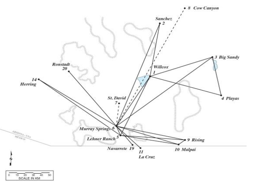
Figure 3: Map of the Cochise Clovis Network During Event time 2, the Clovis Occupation of Area 3 at Murray Springs
When compared, the maps of event time 1 and event time 2 were found to have notable differences. If a hypothetical line could be drawn north to south through Murray Springs, only one node evident during event time 1, node 14 (Herring), remained on the western side of the network during event time 2, while all but one of the nodes on the eastern side remained. The only unmapped node on the eastern side, node 12 (Leikem) was not shown on Figure 2 because it represented a single kill event that was previously connected to Lehner Ranch during event time 1. Evidently, during the brief time between the Clovis occupations of Area 4/5 and the occupation of Area 3, 12 links and 6 nodes were removed from the western side of the network. Nearly all of the deleted nodes were in the Sonoran Desert region. There could have been limited growth in the network between the Clovis occupations of Area 4/5 and Area 3.
New nodes evidently were added connecting Murray Springs to nodes 19 (Navarrete) to the southeast and 20 (Ronstadt) to the northwest. Additionally, by maintaining a link distribution that was consistent with a power law and by keeping its social grouping layers, the network evidently was robust to the loss of numerous links and nodes on the western side. The relative stability of the eastern side of the network was reflected in the raw materials found in Area 3. All of the raw material that previously connected Area 4/5 to the eastern side of the network were found in Area 3 (St. David chalcedony, brownish gray chert, Cow Canyon obsidian, dark gray basalt, red jasper, and grayish brown chert). In contrast, the only raw material remaining in Area 3 that previously connected Area 4/5 to the western side of the network was red jasper.
The loss of connections to the Sonoran Desert on the western side of the network during event time 2 agrees with demographic and environmental reconstructions of the time and may not have been due to sampling error. It is probable that the decline of the network from the western side of the network was part of the withdrawal of big game hunters (such as Clovis) from the Sonoran Desert region noted by Ballenger and others [32,45]. This withdrawal began during Clovis times and evidently was a response to increasingly dry conditions and the limited range of bison [13,17,45-47].
Discussion
The Decline of the New York Garment Industry (NYGI) Network
Declining networks emerge in a number of areas such as the progressive loss of neurons in Alzheimer’s disease and the decline of the telegraph, which gradually disappeared following the second world war [22]. A recent study of the declining New York Garment Industry (NYGI) network provided insight into the declining Cochise Clovis network [48]. In the NYGI network, nodes corresponded to designers and contractors who were linked through coproductions of annual runs of lines of clothing.
Designers designed clothing and contractors fabricated it, but their roles often overlapped because the industry’s low-cost and quick-to-market conditions entwined design and production [48]. Between 1985 and 2003, the NYGI network declined through an asymmetric disassembly process for contraction that was combined with a partial recovery process for regrowth. The asymmetric disassembly process favored asymmetric interactions between extreme low and high degree nodes such that the least and best-connected firms in the network were especially resistant to the loss of links. Working in concert with the asymmetric disassembly process, the partial recovery process added new nodes to the NYGI network while it was in decline. Partial recovery followed preferential attachment, such that the new firms were more likely to be connected to existing high degree nodes [48].
Initially, the NYGI network exhibited a remarkably robust topology and stable performance measures while undergoing severe decline. The observed network robustness to severe decline was considered a consequence of the enhanced functional and structural preference for asymmetric interactions. The fraction of links with errors, denoted by refunds caused by design mistakes, shorted goods, and manufacturing errors, remained reasonably stable between 1985 and 1998. After 1998 the mean and variability of the fraction of links with errors rose significantly. Ultimately the NYGI network collapsed into a highly centralized configuration characterized by elevated error rates and reduced overall performance [48].
The Cochise Clovis Network Declines from the Sonoran Desert
Though it should be viewed with caution due to the limited sample size, in many ways the decline of the Cochise Clovis network from the Sonoran Desert was reminiscent of the declining NYGI network. Showing signs of asymmetric decline, by the time of the Clovis occupation of Area 3 at Murray Springs, only two small nodes, (Herring and Ronstadt) and the largest network hub at Murray Springs, which was adjacent to the Sonoran Desert and evidently impacted by the drought, remained active on the western side of the network. There also were hints that partial recovery and preferential attachment could have been concurrent with node removal in the declining Cochise Clovis network. Nodes 19 (Navarrete) and 20 (Ronstadt), each with only a single link, evidently were added to the network and connected to the largest node at Murray Springs while the network was in decline.
As in the declining NYGI network, there also were errors in the Cochise Clovis network, particularly at Murray Springs. Many of these errors were caused by misstrikes and/or breakage and might be expected to occur in sites with manufacturing activities such as Willcox and Murray Springs. These manufacturing errors included the broken stage-four biface from the Willcox site (Figure 1), and three misstruck blades, two primary bifaces that had transverse bend breaks and a broken biface from Murray Springs [5,18]. However, two errors found in the Area 3 assemblage at Murray Springs were more unusual and could be evidence that the error rate was increasing and now included unfinished and shorted goods.
For example, a complete but poorly made Clovis point found in the Area 3 bone bed had a projection on one surface, lacked basal edge grinding, and was possibly unfinished [18]. This point evidently was pressed into service even though it was not complete.
A three spurred graver, also found in Area 3, was constructed on a midsection fragment of a flake and could have been an example of a shorted, or inferior tool made from a byproduct of another manufacturing process. Each of the three spurs on this tool was produced by notching just inside the broken edge of a flake fragment, such that each spur incorporated a portion of the broken edge of the flake [5]. This graver was unlike others found at Murray Springs, Lehner, and Blackwater Draw which were made from biface reduction or primary flakes that had one or two spurs made by pressure flaking [5,49,50-55].
Conclusions
A Clovis band in Southeastern Arizona and adjacent regions of the Southwest evidently was supported by a regional social network that may have been a small world. Foraging party (noted at node 9 or Rising), seasonal aggregation (noted at node 1 or Willcox) and nested foraging party and periodic aggregation (noted at node 6 or Murray Springs) social grouping layers were evident in the network. The network evidently declined from the Sonoran Desert region on its western side during a drought but retained links on its eastern side. With only a few small nodes and a single large hub remaining, the decline of the western portion of the network might have been asymmetric. The network evidently was robust to the loss of numerous links and nodes on the western side.
Acknowledgements
I thank Eric Kaldahl (director), and Christine Szuter (former director), of the Amerind Foundation for the opportunity to study Clovis networks as a Resident Scholar; Albert-Lazlo Barabasi for providing advice concerning networks; Bruce Huckell for numerous consultations and assistance with lithic raw material; C. Vance Haynes, Jr. for providing feedback on a draft manuscript; Jesse Ballenger, David Dechant, Marty Tagg, Anna Schneider, and Sara Cullen for assistance with pedestrian surveys; Cynthia Bettison, Mary Kearney, Gay Kincade, Dan McGrew, Rebecca Orozco, Jim Neely, Warner Glenn, Kelly Kimbro, Mary Prasciunas, Tom Euler, Joe Conner, William Bryce, Kyle Meredith, Evan Giomi, Michael O’Hara, Natalia Chang, Nugent Brasher, Bucky Reed, Bruce Bradley, Guadalupe Sanchez, and Robert Wegener for contributing information about Clovis assemblages in the study region; Matilda Essig for the artifact illustrations; Allison Bruce for the network maps; Kathryn MacFarland, Suzanne Eckert, Todd Pitezel, and Arthur Vokes for providing information about Clovis artifacts housed in the Arizona State Museum; Alan Slade for information about the Thomas C. Kelly collection in the British Museum; Juliet Morrow for assistance with the identification of Clovis artifacts; and Eric Kaldahl for photographing Clovis artifacts in the Amerind Museum collections.
References
- Stanford, D. (1999). Paleoindian archaeology and late Pleistocene environments in the Plains and southwestern United States. In Ice Age people of North America: Environments, origins, and adaptations, (pp 281-339). Oregon State University.
- Waters, M. R., Stafford Jr, T. W., & Carlson, D. L. (2020). The age of Clovis—13,050 to 12,750 cal yr BP. Science Advances, 6(43), eaaz0455.
- Fiedel, S. J. (2014). The Clovis-era radiocarbon plateau. In Clovis: on the edge of a new understanding, (pp 11-19). Texas A & M University.
- Huckell, B. B., & Haynes, C. V. (2007). Clovis paleoecology as viewed from Murray Springs, Arizona. In Murray Springs: A Clovis site with multiple activity areas in the San Pedro Valley, Arizona (pp. 214-225). University of Arizona.
- Huckell, B. B. (2007). Clovis lithic technology: A view from the upper San Pedro Valley. In Murray springs: A Clovis site with multiple activity areas in the San Pedro Valley, Arizona (pp. 170-213). University of Arizona.
- Haury, E. W., Sayles, E. B., & Wasley, W. W. (1959). The Lehner mammoth site, southeastern Arizona. American Antiquity, 25(1), 2-30.
- Haury, E. W., Antevs, E., & Lance, J. P. (1953). Artifacts with mammoth remains, Naco, Arizona. American Antiquity, 19(1), 1-24.
- Boldurian, A. T., & Cotter, J. L. (1999). Clovis revisited: new perspectives on Paleoindian adaptations from Blackwater Draw, New Mexico (Vol. 103). UPenn Museum of Archaeology.
- Eren, M. I., Story, B., Perrone, A., Bebber, M., Hamilton, M., Walker, R., & Buchanan, B. (2020). North American Clovis point form and performance: An experimental assessment of penetration depth. Lithic Technology, 45(4), 263-282.
- Howard, E. B. (1933). Association of artifacts with mammoth and bison in eastern New Mexico. Science, 78, 524.
- Haynes, C. V. (1966). Elephant-hunting in North America.Scientific American, 214(6), 104-115.
- Morrow, J. E. (2014). Clovis-era point production in the Midcontinent. In Clovis: on the edge of a new understanding, (pp 83-107). Texas A & M University.
- Sanchez, G. (2016). Los primeros Mexicanos: Late Pleistocene and early Holocene people of Sonora (Vol. 76). University of Arizona.
- Haynes, C. V. (2008). Younger Dryas “black mats” and the Rancholabrean termination in North America. Proceedings of the National Academy of Sciences, 105(18), 6520-6525.
- Faith, J. T., & Surovell, T. A. (2009). Synchronous extinction of North America's Pleistocene mammals. Proceedings of the National Academy of Sciences, 106(49), 20641-20645.
- Holliday, V. T., & Miller, D. S. (2013). The Clovis landscape. InPaleoamerican odyssey (pp 221-245). Texas A & M University.
- Haynes, C. V. (2007). Quaternary geology of the Murray Springs Clovis site. In Murray Springs: A Clovis site with multiple activity areas in the San Pedro Valley, Arizona. (pp 16-56) University of Arizona.
- Hemmings, E. T. (2007). Buried animal kills and processinglocalities, areas 1-5. In Murray Springs: A Clovis site with multiple activity areas in the San Pedro Valley, Arizona (pp. 83-137). University of Arizona.
- Agenbroad, L. D., Huckell, B. B. (2007). The hunting camp at Murray Springs. In: Murray Springs: A Clovis site with multiple activity areas in the San Pedro Valley, Arizona (pp 146-169). University of Arizona.
- Lovis, W.A., Hitchcock, R. K., & Whallon, R. (2011). Preface In Information and its role in hunter-gatherer bands. (pp xi- xvi). Cotsen Institire of Technology.
- Pearce, E., & Moutsiou, T. (2014). Using obsidian transfer distances to explore social network maintenance in late Pleistocene hunter–gatherers. Journal of anthropological archaeology, 1, 12-20.
- Barabasi, A. -L. (2016). Network science. Cambridge Universi-ty, Cambridge CB2 8BS, UK
- Phillips, S. (2011). Networked glass: lithic raw material consumption and social networks in the Kuril Islands, far eastern Russia (Doctoral dissertation).
- Buchanan, B., Hamilton, M. J., Kilby, J. D., & Gingerich, J.A. (2016). Lithic networks reveal early regionalization in late Pleistocene North America. Journal of Archaeological Science, 65, 114-121.
- Buchanan, B., Andrews, B., Kilby, J. D., & Eren, M. I. (2019). Settling into the country: Comparison of Clovis and Folsom lithic networks in western North America shows increasing redundancy of toolstone use. Journal of Anthropological Archaeology, 53, 32-42.
- Buchanan, B., Hamilton, M. J., & Kilby, J. D. (2019). The small-world topology of Clovis lithic networks. Archaeological and Anthropological Sciences, 11, 3537-3548.
- Slade, A. M. (2018). An early North American fluted point assemblage rediscovered: the Thomas C. Kelly Collection in the British Museum, London. Lithics–The Journal of the Lithic Studies Society, (39), 68-76.
- Huckell, B. B. (1982). The distribution of fluted points in Arizona: A review and update. Cultural Resource Management Division, Arizona State Museum, University of Arizona, Archaeological Series No. 145.
- Prasciunas, M. M. (2011). Mapping Clovis: projectile points, behavior, and bias. American Antiquity, 76(1), 107-126.
- Judge, W. J., & Dawson, J. (1972). Paleoindian settlement technology in New Mexico: Both intercultural and intracultural variations in settlement are defined by an archeological survey. Science, 176(4040), 1210-1216.
- Naze, B. S. (1986). The Folsom occupation of Middle Park,Colorado. Southwestern Lore, 52(4), 1-32.
- Ballenger, J. A., Holliday, V. T., Kowler, A. L., Reitze, W. T., Prasciunas, M. M., Miller, D. S., & Windingstad, J. D. (2011). Evidence for Younger Dryas global climate oscillation and human response in the American Southwest. Quaternary International, 242(2), 502-519.
- Di Peso, C. C. (1953). Clovis fluted points from southeasternArizona. American Antiquity, 19(1), 82-85.
- Haynes, C. V. (2011). Distribution of Clovis Points in Arizonaand the Clovis Exploration of the State, 11,000 BC. Kiva, 76(3), 343-367.
- Gaines, E. P. (2006). Paleoindian Geoarchaeology of the Upper San Pedro River Valley, Sonora, Mexico. University of Arizona.
- Huckell, B. B. (1972). A Fragmentary Clovis Point fromSouthwestern New Mexico. Kiva, 37(2), 114-116.
- Hamilton, M. J., Buchanan, B., Huckell, B. B., Holliday, V. T., Shackley, M. S., & Hill, M. E. (2013). Clovis paleoecology and lithic technology in the central Rio Grande rift region, New Mexico. American Antiquity, 78(2), 248-265.
- Barabasi, A.-L. (2002). The new science of networks. Cambridge MA, Perseus.
- Newman, M. E. (2010). Networks: an introduction. Oxford University.
- Binford, L. R. (1983). In pursuit of the past: decoding thearchaeological record. University of Arizona.
- Haynes, C. V. (1980). The Clovis culture. Canadian Journal of Anthropology, 1(1), 115-121.
- Steward, J. H. (1972). Theory of culture change: Themethodology of multilinear evolution. University of Illinois.
- Birdsell, J. B. (1968). Some predictions for the Pleistocene based on equilibrium systems among recent hunter-gatherers. In Man the hunter (pp. 229-240). Routledge.
- Jochim, M. A. (1976). Hunter-gatherer subsistence andsettlement: A predictive model. Academic.
- Ballenger, J., Holliday, V., & Sanchez, G. (2017). The earliest people in the Southwest. The Oxford Handbook of Southwest Archaeology. Oxford.
- Betancourt, J. L. (1990). Late Quaternary biogeography of theColorado Plateau. In Packrat middens – the last 40,000 years ofbiotic change (pp 259-292). University of Arizona.
- Haynes, C. V. (1991). Geoarchaeological and paleohydrological evidence for a Clovis-age drought in North America and its bearing on extinction. Quaternary Research, 35(3-Part1), 438- 450.
- Saavedra, S., Reed-Tsochas, F., & Uzzi, B. (2008). Asymmetric disassembly and robustness in declining networks. Proceedings of the National Academy of Sciences, 105(43), 16466-16471.
- Hester, J. J. (1972). Blackwater locality No. 1: A stratified early man site in eastern New Mexico. Fort Burgwin Research Center No. 8.
- Warnica, J. M. (1966). New discoveries at the Clovis site.American Antiquity, 31(3Part1), 345-357.
- Agenbroad, L. D. (1967). The distribution of fluted points inArizona. Kiva, 32(4), 113-120.
- Ayers, J. E. (1970). Two Clovis fluted points from southernArizona. Kiva 35(3), 121-124.
- Simpson, K. & Wells, S. J. (1984). Archaeological survey in the eastern Tucson Basin. Western Archaeological and Conservation Center, National Park Service, U.S. Department of the Interior.
- Hesse, I. S. (2010). Clovis fluted point found near Tucson,Arizona. Arizona Archaeological Council Newsletter 34(8).
- Haynes, C. V. (2007). Clovis investigations in the san pedro valley. In Murray Springs: A Clovis site with multiple activity areas in the San Pedro Valley, Arizona (pp 1-15). University of Arizona.