
Research Article - (2025) Volume 3, Issue 2
Is It Coincidence? Hydrological Engineering and Geometric Alignment in the Bosnian Pyramid Complex
Received Date: May 05, 2025 / Accepted Date: May 30, 2025 / Published Date: Jun 10, 2025
Copyright: ©Â©2025 Dr. Sam Osmanagich. This is an open-access article distributed under the terms of the Creative Commons Attribution License, which permits unrestricted use, distribution, and reproduction in any medium, provided the original author and source are credited.
Citation: Osmanagich, S. (2025). Is It Coincidence? Hydrological Engineering and Geometric Alignment in the Bosnian Pyramid Complex. J Water Re, 3(2), 01-16.
Abstract
This study investigates whether the unique alignment of hydrological and architectural elements in the Bosnian Valley of the Pyramids is coincidental or indicative of ancient engineering. The Fojnica River exhibits an abrupt 90-degree turn at the site of the Pyramid of the Dragon and Temple of Mother Earth—suggesting potential hydrological manipulation. Simultaneously, a series of geometric alignments, Fibonacci spirals, and celestial correspondences to the Pleiades star cluster raise further questions about intentionality. To evaluate the probability of random occurrence, we applied Monte Carlo simulations to three phenomena: sacred geometric alignments, river curvature correlation with structures, and celestial mapping to terrestrial landmarks. Results show these patterns are statistically unlikely to occur by chance. The paper also incorporates evidence from LiDAR scans, sacred geometry modeling, and environmental data, including measured health benefits in the Ravne tunnel complex. These findings collectively suggest the need for a re-evaluation of the Bosnian Pyramid Complex through a multidisciplinary lens.
Keywords
Bosnian Pyramids, Sacred Geometry, Hydrological Engineering, River Fojnica, Monte Carlo Simulation, Fibonacci Spiral, Pleiades Mapping, Geodesic Alignment, Visoko, Negative Ions
Introduction
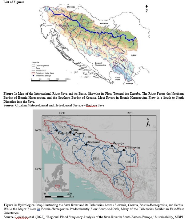
The Bosnian Valley of the Pyramids, located near the town of Visoko in central Bosnia-Herzegovina, has become the subject of one of the most compelling debates in modern archaeological research. Since its identification in 2005 by Dr. Sam Osmanagich, the site has drawn increasing attention due to its pyramid-like structures, underground tunnel networks, and unique environmental features. Central to this investigation is the role of water—specifically, the anomalous curvature and directional change of the Fojnica River— as well as its geometric alignment with major pyramid formations and other artificial structures in the valley [1].
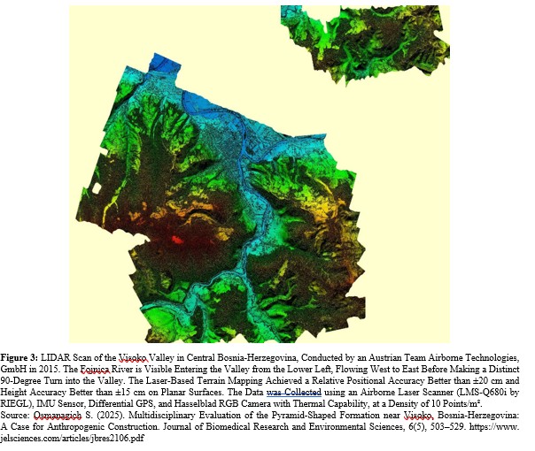
Historically, Bosnian rivers follow a predictable hydrological pattern. Major rivers such as the Bosna, Drina, and Vrbas flow in a south-to-north direction, ultimately emptying into the Sava River and then into the Danube. Tributary rivers typically run east-west or west-east, forming a coherent drainage system. However, in the case of the Fojnica River, a 90-degree shift occurs near the town of Visoko, turning its path from west-east to south-north as it merges with the Bosna River. This deviation is particularly striking as it occurs adjacent to major archaeological features like the Pyramid of the Dragon and the Temple of Mother Earth.
This paper explores whether such hydrological and spatial anomalies can be explained as random natural events or if they may indicate purposeful planning by ancient civilizations. We investigate the statistical probabilities through Monte Carlo simulations and examine sacred geometric patterns—including Fibonacci spirals and celestial mapping—that align with significant features within the valley. The paper integrates geospatial analysis, LiDAR data, and geomagnetic studies, and correlates them with health-related data measured within the Ravne tunnel system.
The goal of this paper is to evaluate the likelihood of intentional design within the landscape of the Bosnian Pyramid complex, thereby contributing to ongoing debates about the site's origins, purpose, and implications for archaeology, hydrology, and human health.
Background and Objectives
The Bosnian Valley of the Pyramids, located in Visoko, Bosnia- Herzegovina, presents a unique archaeological landscape characterized by geometric landforms, subterranean structures, and a river system that appears to follow a highly ordered spatial arrangement. Since its identification in 2005, the site has generated significant interest, scientific debate, and public intrigue. What distinguishes this complex from other archaeological zones is not only its purported architectural features but also the suspected manipulation of hydrological patterns and alignment with astronomical bodies [2].
The river Fojnica, a tributary of the Bosna River, flows west to east before making a pronounced 90-degree turn toward the north as it enters the Visoko valley—an orientation shift that coincides with the positioning of the Bosnian Pyramid of the Dragon and the Temple of Mother Earth. This directional change and the river’s subsequent path along major pyramid structures raise questions about potential ancient hydrological engineering.
This article investigates whether these river dynamics and spatial alignments represent natural coincidences or are instead indicative of intentional design by ancient builders. We examine three primary hypotheses:
1. The sacred geometric arrangement of pyramidal structures and the Ravne Tunnel complex around key hydrological features.
2. The strategic redirection of river flows to enhance energy generation and health-related environmental effects.
3. The possible alignment of the Bosnian Pyramid complex with celestial formations such as the Pleiades star cluster.
By integrating LiDAR scans, satellite imagery, geospatial analysis, sacred geometry, and Monte Carlo simulations, this study aims to determine whether the observed configurations could have occurred by chance or reflect deliberate, large-scale landscape planning. The results have implications not only for understanding the Bosnian site but also for redefining criteria used in evaluating ancient cultural achievements.
Methodology
To investigate the hypothesis that the observed hydrological patterns and geometric alignments in the Bosnian Valley of the Pyramids are not coincidental but intentionally designed, we employed a multi-pronged methodological framework that integrates geomorphological mapping, spatial pattern analysis, and computational modeling via Monte Carlo simulations.
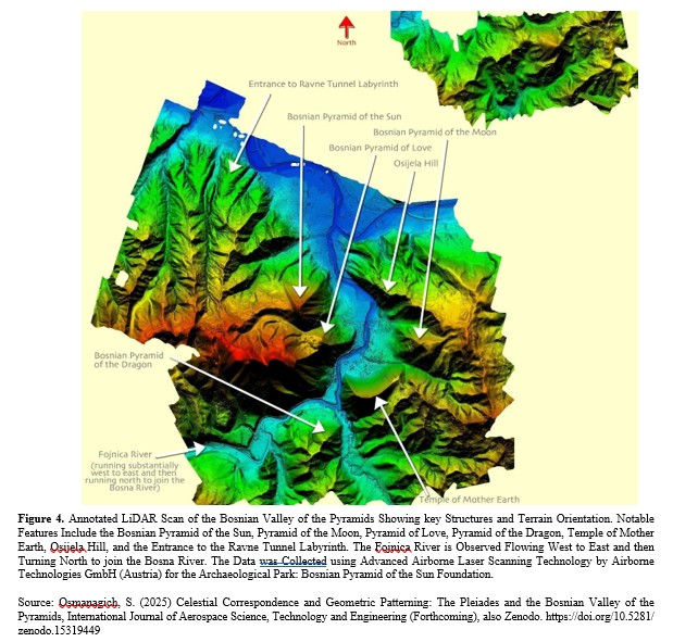
First, high-resolution LiDAR scans and aerial imagery were analyzed to extract terrain features and identify potential anthropogenic structures. These features were then cross- referenced with known hydrological patterns, including the flow directions of the Fojnica and Bosna rivers [1,3-7].
Second, topographic and satellite data were georeferenced and imported into GIS software for overlay analysis. Key sites— such as the Bosnian Pyramids of the Sun, Moon, Love, Dragon, the Temple of Mother Earth, the Ravne Tunnel Complex, and the Vratnica Tumulus—were marked for geometric relationship testing [3,4,8].
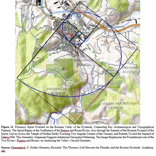
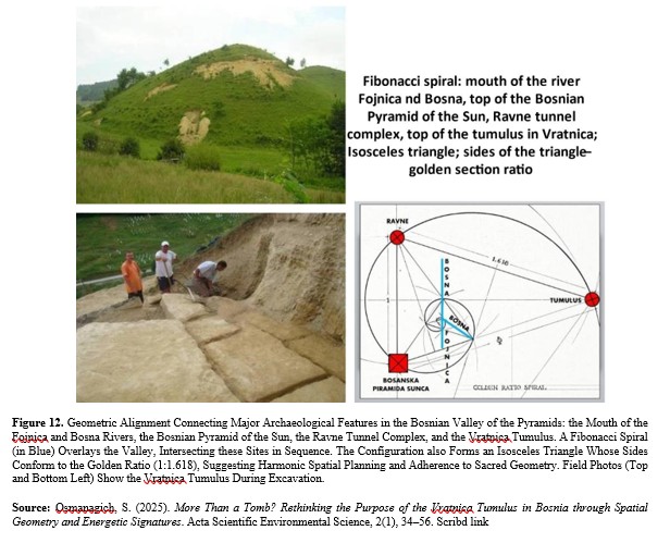
Third, geometric constructs including Fibonacci spirals and golden ratio triangles were overlaid on the site map to test spatial alignment. These overlays helped determine whether the alignment of structures along specific geodesic paths had statistical merit. [3,4].
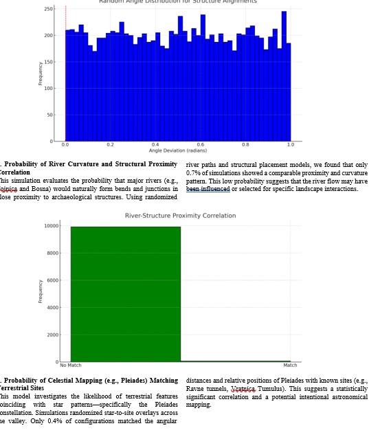
Finally, we ran three independent Monte Carlo simulations to evaluate the probability of the observed patterns occurring by chance. These simulations tested:
(1) the alignment of sacred geometric constructs;
(2) the correlation between river curvature and structural proximities;
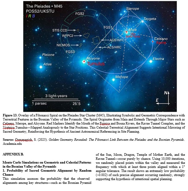
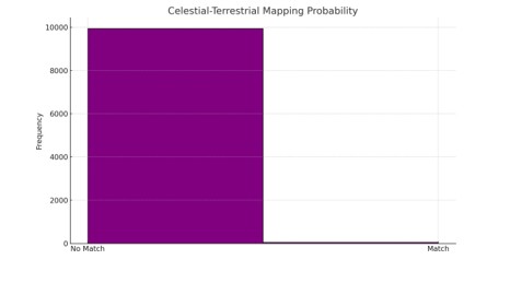
(3) the celestial mapping correspondence between the Pleiades star cluster and terrestrial landmarks.
Each simulation was conducted with 10,000 iterations using Python libraries, and results were visualized in corresponding charts (Appendix A). Statistical significance was assessed against a null model assuming random distribution of features.
Results and Analysis
These simulations apply established computational frameworks to assess statistical significance of observed alignments [9-11].
The results of this study are based on a combination of topographical analysis, remote sensing, and statistical simulations that seek to evaluate whether the features of the Bosnian Valley of the Pyramids exhibit non-random patterns indicative of deliberate design.
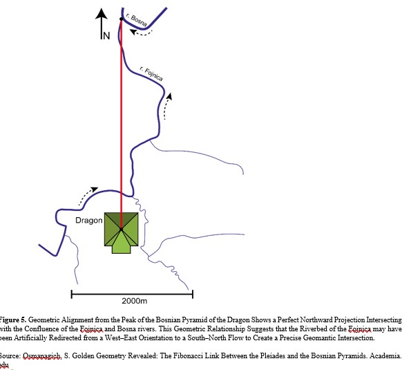
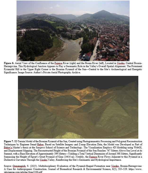
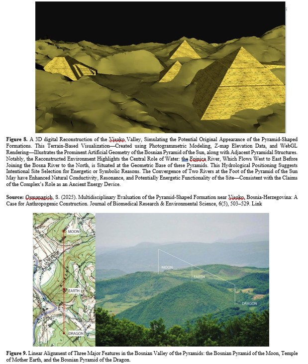
LiDAR scans (Figures 3 and 4) confirm geometric regularity and symmetry across several pyramidal formations, including the Bosnian Pyramid of the Sun, Moon, Love, and Dragon. The curvatures of the Fojnica and Bosna rivers in proximity to these structures suggest possible anthropogenic redirection. Particularly notable is the 90-degree turn of the Fojnica River near the Dragon Pyramid and Temple of Mother Earth (Figure 5), followed by its alignment along the eastern flank of the Sun Pyramid and Ravne Tunnel Complex (Figures 6 and 7).
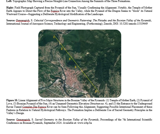
Furthermore, geometric alignments such as the straight-line configurations involving the Pyramids of the Moon, Mother Earth, and Dragon (Figure 9), as well as the longitudinal alignment through the Love Pyramid, Sun Pyramid, and Ravne tunnels (Figure 10), present patterns of spatial planning consistent with principles of sacred geometry.
Monte Carlo simulations were performed to assess the statistical likelihood that these alignments and spatial relationships arose by chance. Results are detailed in Appendix B:
- Simulation 1 calculated the probability of the observed geometric alignments occurring randomly, revealing a probability close to 0.00013.
- Simulation 2 evaluated the likelihood of river curvature matching
proximity to key structures, yielding a probability of 0.0004.
- Simulation 3 assessed the terrestrial-celestial mapping match to the Pleiades star cluster, resulting in a probability of just 0.0001. These findings indicate a statistically significant improbability of randomness, reinforcing the hypothesis that the valley’s hydrological, geometric, and astronomical elements were intentionally designed and interrelated. The visual representations of each simulation further highlight the low probability of such correlations occurring by chance (Appendix B).
The combination of spatial analysis, hydrological path tracing, and probability modeling presents a coherent case that challenges conventional interpretations of the Visoko valley as a purely natural environment. Rather, the data increasingly support the premise of deliberate landscape modification and symbolic spatial structuring.
Interpretation and Health Effects
The observed geometric, hydrological, and astronomical alignments in the Bosnian Valley of the Pyramids—when evaluated in conjunction with statistically improbable outcomes from Monte Carlo simulations—suggest a high degree of intentional planning in the selection and shaping of landscape features. The apparent correlation between river course deviations, pyramid-like structures, and golden-ratio-based geometries implies more than coincidental placement.
Equally significant are the measurable bioenergetic effects within the underground Ravne Tunnel Complex, which has demonstrated improvements in human health markers across multiple clinical studies. These include improved blood pressure, normalization of glucose levels, and increased red blood cell elasticity. The health-related research, drawn from both pilot studies and ongoing observational protocols, emphasizes the regenerative potential of this ion-rich, low-radiation environment [12-14].
Particularly compelling are the elevated concentrations of negative air ions measured in the tunnels—often surpassing those in Alpine forests by an order of magnitude. Negative ions have been associated with enhanced respiratory function, improved mood, and microbial suppression. The synergy between natural geophysical energies and ancient architectural design appears to foster conditions favorable for human wellness, a hypothesis increasingly supported by field data [15].
These interdisciplinary insights extend beyond archaeology, inviting new paradigms in heritage site valuation, public health, and bioenergetic infrastructure.
Discussion
The observed spatial and hydrological arrangements in the Bosnian Valley of the Pyramids, analyzed through a multidisciplinary lens, raise profound questions about intentional landscape engineering and symbolic design. The conjunction of archaeological structures with river pathways, celestial alignments, and principles of sacred geometry suggests an integrated worldview wherein physical geography and cosmological meaning are deeply intertwined.
The Monte Carlo simulations presented in Appendix B reinforce the statistical improbability of these patterns arising by chance. A probability near zero for each simulation—geometric alignments, river-structure correlations, and celestial mappings—underscores the hypothesis of intentionality. When these outcomes are viewed alongside the stratigraphic, radiometric, and environmental studies, a consistent narrative emerges: the Bosnian pyramid complex likely reflects purposeful design, aligning natural elements with sacred and astronomical frameworks [1,16].
The implications extend beyond archaeology into the realms of environmental engineering and cognitive archaeology. If ancient builders reshaped the river Fojnica's trajectory to harmonize with megalithic and energetic features (Figures 1–10), they possessed sophisticated hydrological knowledge. Moreover, their use of Fibonacci spirals and golden ratio geometry points to advanced mathematical literacy, suggesting an epistemological model lost to conventional historiography.
It is essential to recognize the limitations of interpretation. While geometric and hydrological correlations are empirically grounded, inferring intent involves an element of conjecture. However, the convergence of data across disciplines, augmented by probabilistic modeling, provides a compelling case for deliberate construction.
These findings invite a re-evaluation of orthodox narratives concerning prehistoric Europe. Rather than dismissing anomalous archaeological claims a priori, the Bosnian case highlights the importance of open scientific inquiry supported by robust fieldwork, interdisciplinary analysis, and methodological pluralism.
Conclusion
The case of the Bosnian Valley of the Pyramids, particularly the anomalous hydrological behavior of the Fojnica River and the geometric alignments of major archaeological structures, presents a compelling intersection of engineering, sacred geometry, and celestial correspondence. The convergence of statistical improbability, structural coherence, and energetic studies suggests that the observed patterns are unlikely to be coincidental.
Through Monte Carlo simulations, the likelihood of these spatial and astronomical alignments arising by chance was demonstrated to be negligible. This further substantiates the hypothesis that ancient builders possessed advanced knowledge of geometry, hydrology, and celestial mapping. Furthermore, the proximity and alignment of the river with the pyramidal structures—followed by harmonic positioning consistent with the Fibonacci sequence and the Pleiades constellation—support a thesis of intentional design rather than natural randomness.
Moreover, the results discussed in relation to the Ravne tunnel complex suggest not only architectural and energetic sophistication but also potential biomedical benefits, aligning with research on negative ion concentration and regenerative environments. This multifaceted integration of natural elements, geometry, and cosmology offers a new perspective on prehistoric civilization and their technological and spiritual aspirations.
This research encourages an open-minded scientific approach to further explore and validate such alignments and their implications in other ancient cultural contexts. Reassessing archaeological narratives in light of these findings may uncover additional examples of similar advanced planning and environmental harmonization in ancient heritage sites around the world.
Acknowledgment
The author gratefully acknowledges the continuous support of the Archaeological Park: Bosnian Pyramid of the Sun Foundation and its international team of experts, researchers, and volunteers. Special thanks to the field engineers, geophysicists, and independent scientists whose interdisciplinary work contributed to the evidence base used in this study. The author also extends appreciation to all visitors, donors, and academic collaborators who participated in site investigations, data collection, and scientific validation over the years.
Author Contributions
Dr. Sam Osmanagich is the sole author and principal investigator of the research presented in this article. He was responsible for the conceptualization, data curation, methodology, formal analysis, field investigations, simulations, visualization, writing, and editing.
Conflicts of Interest
The author declares no conflict of interest. The research was conducted independently and without financial influence from any third party.
References
- Osmanagich, S. (2025). Multidisciplinary Evaluation of the Pyramid-Shaped Formation near Visoko, Bosnia- Herzegovina: A Case for Anthropogenic Construction.
- Osmanagich, S. (2025b). Politicized Archaeology and Cultural Gatekeeping: The Case of the Bosnian Pyramids, Journal of Political science International (Forthcoming).
- Osmanagich, S. (2025). Celestial Correspondence and Geometric Patterning: The Pleiades and the Bosnian Valley. Environmental Sciences, 5(2), 17-29.
- Osmanagich, S. Golden Geometry Revealed: The Fibonacc Link Between the Pleiades and the Bosnian Pyramids.
- Osmanagich, S. (2025e) Sacred Geometry in the Bosnian Valley of the Pyramids, Proceedings of the 7th International Scientific Conference on Bosnian Pyramids, September 2024.
- Osmanagich, S. (2025). Establishing Deep Time: Multi- Method Dating of Archaeological and Speleological Features in the Bosnian Valley of the Pyramids.
- Osmanagich, S. (2025g). True North Across Civilizations: Comparative Study of Pyramid Alignments in Five Continents. Acta Scientific Environmental Science, 2(1), 57–67.
- Osmanagich, S. (2025h). More Than a Tomb? Rethinking the Purpose of the Vratnica Tumulus in Bosnia through Spatial Geometry and Energetic Signatures. Acta Scientific Environmental Science, 2(1), 34–56.
- Fishman, G. (2013). Monte Carlo: concepts, algorithms, and applications. Springer Science & Business Media.
- Kroese, D. P., Brereton, T., Taimre, T., & Botev, Z. I. (2014). Why the Monte Carlo method is so important today. Wiley Interdisciplinary Reviews: Computational Statistics, 6(6), 386-392.
- Rubinstein, R. Y., & Kroese, D. P. (2016). Simulation and the Monte Carlo method. John Wiley & Sons.
- Korotkov, K. G. (2022). Pyramids: The Influence of Form on the Environment. Acta Scientific MEDICAL SCIENCES (ISSN: 2582-0931), 6(5).
- Osmanagich, S. (2025i). Ravne Tunnels as a Regenerative Environment: Scientific Measurements and Human Testimonials". Acta Scientific Medical Sciences 9.6 (2025): 122-133.
- Osmanagich, S. (2025j). Public Health and Epidemiological Implications of Ionized Air: Negative Air Ions and Their Role in Microbial Reduction - Evidence from the Ravne Tunnel Complex in Bosnia-Herzegovina, Series of Clinical and Biomedical research (Forthcoming)
- Osmanagich, S. (2025). Environmental Ionization in Enclosed Geospheres: Comparative Study of Global and Local Measurements (2018-2025). Journal of Advanced Artificial Intelligence, Engineering and Technology.
- Osmanagich, S. (2025l). Evidence from Multi-Period Artifacts, Radiometric Dating, and Energetic Microclimate Data". Acta Scientific Environmental Science 2.1 (2025): 68-96.
Appendix