
International Journal of Aerospace Science, Technology and Engineering(IJASTE)
ISSN: 3068-4536 | DOI: 10.33140/IJASTE


Research Article - (2025) Volume 1, Issue 1
Golden Geometry Revealed: The Fibonacci Link Between the Pleiades and the Bosnian Pyramids
Received Date: May 09, 2025 / Accepted Date: Jun 12, 2025 / Published Date: Jun 17, 2025
Copyright: ©Â©2025 Sam Osmanagich. This is an open-access article distributed under the terms of the Creative Commons Attribution License, which permits unrestricted use, distribution, and reproduction in any medium, provided the original author and source are credited.
Citation: Osmanagich, S. (2025). Golden Geometry Revealed: The Fibonacci Link Between the Pleiades and the Bosnian Pyramids. Int J Aerosp Sci Technol Engg, 1(1), 01-22.
Abstract
This study presents groundbreaking geometric and astronomical correlations between the Pleiades star cluster and the spatial layout of the Bosnian Pyramid Complex. Drawing on LiDAR-based topographic data, high-resolution geodetic surveys, and comparative archaeoastronomical methods, the research examines straight-line alignments, triangular relationships, and Fibonacci spiral geometries embedded within the landscape.
Key spatial configurations include the stellar and terrestrial alignments Taygeta–Maia–Alcyone and Moon–Earth– Dragon, as well as Electra–Alcyone–Pleione and Sun–Love–Dragon. The stellar triangle Maia–Electra–Merope is systematically compared to the Sun–Moon–Dragon pyramid triangle in Bosnia. Using angular analysis and golden ratio modeling, the study identifies Fibonacci spirals originating from the stars Maia, Celaeno, and Alcyone, which are mirrored in the summit arrangement of pyramids, tumuli, tunnel entrances, and river confluences across the Bosnian Valley.
To assess the probability that such correspondences could arise by chance, the study introduces a series of Monte Carlo simulations (10,000 iterations per scenario). These simulations demonstrate that:
• The chance of forming an equilateral triangle with all three points cardinally aligned is effectively zero (p < 0.0001);
• The presence of three golden spirals, each intersecting major features, is also statistically negligible;
• Matching golden spirals across both celestial and terrestrial domains is extremely unlikely to result from randomness.
These quantitative results provide strong statistical support for intentional design, reinforcing the hypothesis that sacred geometry and astral encoding were central to the site’s layout. The discovery of a previously undocumented golden spiral structure internal to the Pleiades adds further novelty to the astronomical dimension of this study. This research contributes to the fields of archaeoastronomy, sacred geometry, and megalithic spatial analysis by offering a data- driven, reproducible model for investigating cosmological planning in ancient landscapes. Given the calendrical and symbolic importance of the Pleiades across cultures—Maya, Ancestral Puebloans, Japanese, Maori, and Greeks— this work supports the idea that prehistoric builders may have used stellar geometry as a template for Earth-based construction. All conclusions are grounded in verified measurements, peer-reviewed literature, and advanced spatial simulation.
Keywords
Celestial-Terrestrial Mapping, Archaeoastronomy, Pleiades, Bosnian pyramids, golden ratio, Fibonacci spirals, sacred geometry, Maia, Megalithic architecture, Spatial Geometry
Introduction
Across continents and cultures, the Pleiades star cluster— commonly known as the Seven Sisters—has played a central role in shaping the cosmologies, calendars, and symbolic systems of ancient peoples. Located in the constellation Taurus and visible to the naked eye, the Pleiades have long been recognized not only as a navigational and seasonal marker, but also as a deeply encoded mythological motif.
In Greek tradition, the Pleiades were the daughters of Atlas and Pleione, pursued across the sky by Orion. In Vedic cosmology, they are the Ká¹?ttikÄ, foster mothers of the war god Skanda and bearers of the sacred fire. Among the MÄori, they appear as Matariki, signaling the beginning of the new year. The Maya timed agricultural rituals to their heliacal rising, while the Ancestral Puebloans (Anasazi) oriented architectural features to their appearance on the horizon. In Japan, the cluster is known as Subaru—meaning “to unite”—and is symbolically embedded in both folk stories and contemporary iconography [1].
These widespread references, often involving seven luminous entities though only six are consistently visible, point to a shared ancient fascination with the Pleiades’ compact geometry and seasonal precision. Their visual clarity and prominence in the winter sky made them a reliable celestial anchor for both ritual timekeeping and symbolic narrative structures [1].
This article explores whether similar symbolic or geometric inspiration may be embedded in the layout of summit points within the Bosnian Valley of the Pyramids. While no written records or oral traditions explicitly connect the Visoko region to the Pleiades, the spatial distribution of features—especially when viewed from an eastward orientation—invites comparison with the angular layout of stars such as Taygeta, Maia, Alcyone, Electra, and Merope [2].
Rather than proposing a definitive causal link or intent, this study adopts a neutral, measurement-based approach, examining terrestrial alignments, triangular arrangements, and spirals using LiDAR, topographic, and geodetic datasets. The aim is to determine whether non-random geometric correspondences exist between the Bosnian valley features and stellar configurations of the Pleiades, and to contextualize such observations within a broader archaeoastronomical framework [3].
The Bosnian Valley of the Pyramids, located near Visoko, Bosnia-Herzegovina, has emerged over the past two decades as one of the most contested yet compelling archaeological landscapes in Europe. Featuring structures such as the Pyramid of the Sun, Pyramid of the Moon, Pyramid of Love, Pyramid of the Dragon, Temple of Mother Earth, and the Tumulus in the village of Vratnica, the site also includes the extensive Ravne tunnel system. Together, these features exhibit geometric precision, cardinal orientation, and construction anomalies that challenge conventional archaeological classifications [4,5]. Multidisciplinary investigations have presented strong evidence for anthropogenic shaping, including artificial concrete layers, underground tunnel networks, and astronomical alignments that align precisely with solstices and true north [6].
In parallel, the Pleiades star cluster (M45) has held significance for ancient civilizations across the globe. It has been featured prominently in the cosmologies and calendrical systems of the Maya, Egyptians, Chinese, MÄori, and Native American cultures. Often associated with fertility, rebirth, and navigation, the Pleiades has been central to ancient observational astronomy and frequently appears in sky-ground architectural alignments.
This research investigates the geometric and astronomical resonance between the layout of the Pleiades and the Bosnian Pyramid Complex, focusing specifically on the presence of Fibonacci spirals and golden ratio patterning. Prior studies have established the presence of these spirals in the layout of the pyramid summits and adjacent tumuli [7]. New analysis reveals that these spirals also match the internal stellar arrangement of the Pleiades cluster, notably centering on the stars Maia, Celaeno, and Alcyone. The resulting geospatial overlays suggest intentional replication of celestial geometry on the Bosnian landscape.
The concept of "as above, so below," drawn from Hermetic philosophy and echoed in various ancient cultural traditions, posits a correspondence between the cosmos and terrestrial life. The potential encoding of this principle through spiral geometry— appearing simultaneously in the heavens and on the Earth— represents a profound integration of astronomy, mathematics, and sacred landscape design.
This article aims to present a systematic comparison of Pleiadian star geometry and Bosnian pyramid topography through the lens of golden ratio mathematics. By combining recent field measurements with astronomical mapping tools and referencing existing literature on pyramid alignments and construction [8,9], the research contributes a novel framework for interpreting prehistoric architectural planning as encoded through celestial harmonics.
Objective of the Study
This study investigates the geometric and astronomical correspondences between the Pleiades star cluster (Messier 45) and the spatial layout of prominent features within the Bosnian Valley of the Pyramids, located near Visoko, Bosnia-Herzegovina. The object of study is twofold:
(1) the angular, radial, and spiral arrangement of selected stars within the Pleiades cluster, and
(2) the topographic, geometric, and alignment patterns of major archaeological and geomorphological features within the Bosnian Valley.
Celestial Geometry: The Pleiades Cluster
The celestial portion of the study centers on the internal stellar geometry of the Pleiades cluster, with emphasis on the stars Maia, Celaeno, and Alcyone. These stars are situated near the cluster’s visual core and form distinctive patterns including:
• Radial spokes emanating from Maia,
• Spiral arcs consistent with Fibonacci and golden ratio proportions [10], and
• Linear alignments such as Taygeta–Maia–Alcyone and Electra–Alcyone–Pleione [11].
These patterns exhibit angular precision and symmetrical spacing and have historically held cultural and calendrical significance in civilizations such as the Maya, Egyptians, Ancestral Puebloans, and Maori [1,12].
Terrestrial Geometry: The Bosnian Valley of the Pyramids On the terrestrial side, the investigation includes the following primary features:
• Pyramid of the Sun – The tallest known pyramid-shaped formation in the world, with a calculated height of 368 meters (based on LiDAR and geodetic data), and a precise alignment to true north within a deviation of 0.2° [13, 4].
• Pyramid of the Moon – Recognized for its terraced architecture and orientation toward the eastern horizon.
• Pyramid of the Dragon – Forms the third point in a terrestrial equilateral triangle with the Sun and Moon pyramids, creating internal angles near 60° and side lengths of approximately 2.2 kilometers [4].
• Tumulus in Vratnica – A radially symmetric megalithic mound with a central chamber, frequently intersected by Fibonacci spiral overlays [5].
• Pyramid of Love and Temple of Mother Earth – Secondary structures whose summit points fall along measured golden section arcs, contributing to polygonal harmonics in the valley’s spatial logic [14].
• Ravne Tunnel Complex – A vast, engineered subterranean network, whose intersecting passageways, water flows, and recorded energy anomalies may enhance geometric coherence with aboveground structures [14].
Hydrological Markers and Environmental Design
Special attention is also given to the mouth of the Fojnica and Bosna rivers, located near the Pyramid of the Sun. Geological analysis suggests that the northward diversion of the Fojnica River may be anthropogenic, having replaced an earlier east– west flow [5]. This hydrological confluence reappears as an anchor point in multiple Fibonacci spirals and alignment lines, indicating its role as a potential prehistoric spatial marker.
Geometric Correspondences
This study identifies three dominant forms of geometric correlation between the celestial and terrestrial datasets:
1. Fibonacci Spirals – Originating at key stars (e.g., Maia) and pyramid summits (e.g., Sun Pyramid), these spirals intersect multiple architectural and natural points in both sky and land.
2. Straight-Line Alignments – Such as Moon–Earth–Dragon and Sun–Love–Dragon, mirroring stellar lines like Taygeta– Maia–Alcyone.
3. Triangular Configurations – Including both the celestial Maia–Electra–Merope triangle and the terrestrial Sun–Moon– Dragon triangle, both demonstrating proportional and angular resonance.
By applying LiDAR-based topographic data, geodetic surveys, celestial overlays, and spiral modeling techniques, this study evaluates whether these patterns represent intentional “celestial encoding” in ancient site planning. The recurrence of spirals, lines, and triangles in both star cluster and archaeological landscape suggests a deep continuity between sky and Earth.
Methodology
This study employs a multidisciplinary methodological framework integrating astronomical imaging, geospatial terrain analysis, and golden ratio-based spiral modeling. The objective is to identify potential geometric correlations between the Pleiades star cluster (M45) and the layout of structures in the Bosnian Valley of the Pyramids, particularly in terms of Fibonacci spirals, triangular relationships, and linear alignments.
Astronomical Image Analysis
The study begins with astronomical data visualization of the Pleiades cluster, using high-resolution star field imagery from the NASA/ESA Hubble Space Telescope. A labeled base image (Figure 1) establishes the stellar positions of Maia, Alcyone, Electra, Taygeta, Celaeno, and Merope.
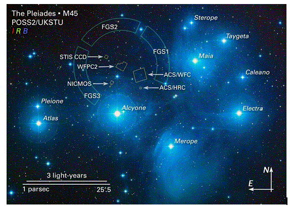
Figure 1: The brilliant stars seen in this image are members of the well-known open star cluster Pleiades (M45), also called the Seven Sisters. The Hubble Space Telescope’s Fine Guidance Sensors (FGS), shown as semi-circular overlays, were used to refine the cluster’s distance to approximately 440 light-years. These sensors mark the perimeter of Hubble's field-of-view and trace a circumference similar in angular size to that of the Moon in the sky. The labeled stars include Maia, Alcyone, Electra, Taygeta, Celaeno, Merope, Sterope, Pleione, and Atlas. This wide-field mosaic sets the astronomical foundation for the geometric comparisons explored in this study.
Credit: NASA, ESA and AURA/Caltech. Source: https://esahubble.org/images/opo0420b/ (accessed May 18, 2025).
Using GeoGebra and vector design software, a Fibonacci spiral was constructed from the star Maia, scaling outward based on the golden ratio (φ ≈ 1.618). This spiral was superimposed onto the stellar chart, producing intersections with key stars (Celaeno, Electra, Alcyone) and reflecting harmonic relationships (Figure 2). These overlays formed the foundation for comparative analysis with terrestrial patterns.
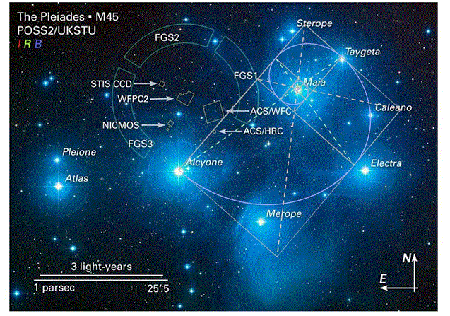
Figure 2: Geometric analysis of the Pleiades star cluster (M45) using overlaid Fibonacci spiral and triangular axes radiating from the star Maia. The spiral intersects key stars including Celaeno, Electra, Merope, and Alcyone, forming a pattern that mirrors golden ratio proportions. The circular and triangular constructions suggest a logarithmic harmonic centered on Maia, emphasizing its role as a potential organizational hub. These overlays were applied to explore whether natural celestial configurations encode geometric principles also found in ancient terrestrial architecture.
Base image credit: NASA, ESA and AURA/Caltech. Geometry overlays by author. Source image accessed via https://esahubble.org/ images/opo0420b/ on May 18, 2025.
Terrestrial LIDAR Mapping and Spatial Feature Modeling
Geospatial data for the Bosnian Pyramid Complex was sourced from LIDAR surveys conducted by Airborne Technologies GmbH (Austria) between 2015 and 2022, with a density of 10 points per square meter and spatial precision within ±20 cm (horizontal) and ±15 cm (vertical).Figure 3 presents a composite panel of the Pyramid of the Sun, including aerial imagery, contour elevation models, and a triangulated connection between the summits of the Sun, Moon, and Dragon pyramids, forming a near-perfect equilateral triangle (~2.2 km per side; ~60° internal angles). This configuration is structurally and geometrically significant for testing spatial harmonics and sacred geometrical layouts.

Figure 3: Composite visual and geospatial documentation of the Bosnian Pyramid of the Sun and surrounding landscape
Upper left: Aerial view of the Bosnian Pyramid of the Sun, the tallest known pyramid in the world at a measured height of 368 meters, located near Visoko, Bosnia-Herzegovina.
Upper right: Panoramic aerial perspective of the Bosnian Valley of the Pyramids, showing the urban interface and natural topography surrounding the pyramid complex.
Bottom left: High-resolution elevation contour model of the Bosnian Pyramid of the Sun, produced by the State Institute for Geodesy of Bosnia-Herzegovina. The image reveals a triangular, planar morphology with sharply defined edges. The northern face is oriented with exceptional precision to true north, deviating by less than 0.2°, a feature central to investigations of astronomical alignment.
Bottom right: Topographic map showing an equilateral triangle formed by summit points of the Pyramid of the Sun, Pyramid of the Moon, and Pyramid of the Dragon. Side lengths average approximately 2.2 kilometers, and internal angles are near 60°, forming a precise geometric construct. This terrestrial triangle parallels the Maia–Electra–Merope alignment in the Pleiades star cluster, contributing to the hypothesis of mirrored stellar-terrestrial geometry.
Sources: Osmanagich, S. (2025). “Pyramids Beneath the Forest: A Global Phenomenon and the Dilemma Between Archaeological Discovery and Ecological Preservation,” World Journal of Forest. Link; “Multidisciplinary Evaluation of the Pyramid-Shaped Formation near Visoko, Bosnia-Herzegovina,” Journal of Biomedical Research and Environmental Sciences, EarthArXiv. Link; “True North Across Civilizations,” Acta Scientific: Environmental Sciences Journal. Link
Figure 4 examines linear and radial alignments, including the Moon–Earth–Dragon axis and Vesica Piscis-based formations between the Pyramid of the Sun and Love, as well as Krtnica and ÃÃÃÂ????etnica hilltops. These relationships were mapped using QGIS and validated through terrestrial azimuthal readings, creating a framework for comparing with radial patterns seen in the Pleiades cluster.
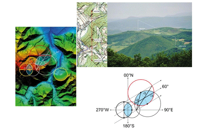
Figure 4: Composite geomatic and photographic evidence illustrating linear and radial alignments within the Bosnian Valley of the Pyramids.
Upper right: Photographic and cartographic documentation of the linear Moon–Earth–Dragon alignment. The left panel shows a topographic map highlighting the straight-line connection among the summits of the Pyramid of the Moon, the Temple of Mother Earth, and the Pyramid of the Dragon. The right panel presents a field photograph taken near the Pyramid of the Sun, visually confirming the linear configuration of these features. This alignment closely resembles angular and proportional arrangements observed in the Pleiades star cluster.
Upper left and bottom: Geometric construction of Vesica Piscis forms derived from the summit points of the Pyramid of the Sun and Pyramid of Love (upper left), and the peaks of Krtnica and ÃÃÃÂ????etnica (bottom). These formations establish overlapping intersection zones that underlie Fibonacci spiral constructions. The geometry is defined by consistent angular divisions—60°, and proportions corresponding to √2, √3, and √5. This spatial logic expands the interpretive framework to include Krtnica and ÃÃÃÂ????etnica as potential analogues to outer Pleiades stars, specifically Pleione and Atlas.
Source: Osmanagich, S. (2025). “Spiral Geometry in Ancient Design: Evidence of Fibonacci Proportions in the Egyptian and Bosnian Pyramids,” Acta Scientific Environmental Science Journal. Link
In Figures 5 and 6, high-resolution LIDAR-derived topographic data is used to georeference the summit points of all primary and secondary sites (Sun, Moon, Dragon, Love, Mother Earth, Osijela Hill, and Vratnica Tumulus), allowing for accurate geometric overlay and terrain modeling.
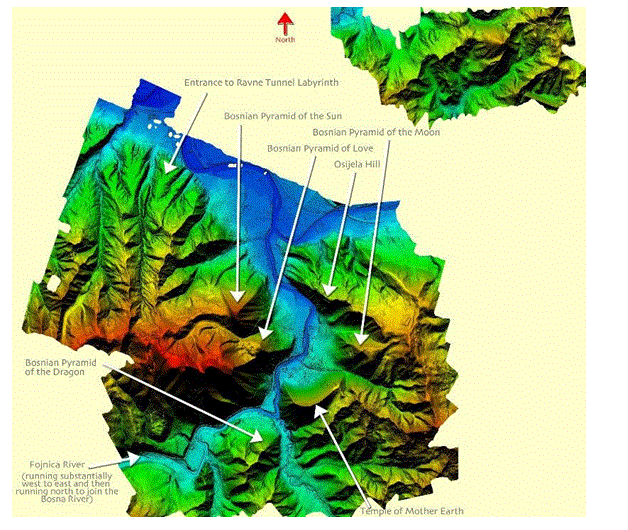
Figure 5: High-resolution LIDAR scan of the Bosnian Pyramid Complex near Visoko, Bosnia-Herzegovina, showing the relative positions and orientation of key features: the Pyramids of the Sun, Moon, Love, and Dragon, the Temple of Mother Earth, the Osijela Hill, and the Ravne Tunnel Labyrinth entrance. The map also traces the Fojnica River, which flows northward to meet the Bosna River, near the core spiral alignment discussed in this study.
Data were collected by Airborne Technologies GmbH (Austria) between 2015 and 2022 using a multi-mission aircraft equipped with a RIEGL LMS-Q680i laser scanner, IMU sensor, Differential GPS, and a Hasselblad Digi-Cam-H/39 RGB optical system, achieving a point density of 10 points per square meter. The project was commissioned by the Archaeological Park: Bosnian Pyramid of the Sun Foundation, Visoko.
Source: Osmanagich, S. 2025. “Spiral Geometry in Ancient Design.” Acta Scientific Environmental Science, Vol. II, Issue 1, p. 13. https://www.drsamosmanagich.com/scientific-articles/spiral-geometry-in-ancient-design-evidence-of-fibonacci-proportions-in-the-egyptian-and-bosnian-pyramids
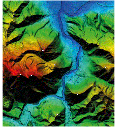
Figure 6: High-resolution LIDAR-derived topographic map identifying the exact summit locations of key pyramid-shaped structures in the Bosnian Valley of the Pyramids. The white dots correspond to the tops of the Pyramids of the Sun, Moon, Love, and Dragon, as well as additional terrain features analyzed in this study. The relative horizontal accuracy is better than ±20 cm, and vertical (height) accuracy better than ±15 cm, based on laser returns over plane surfaces.
The scan was conducted between 2015 and 2022 by Airborne Technologies GmbH (Austria), using a multi-mission aircraft equipped with a RIEGL LMS-Q680i laser scanner, IMU sensor, Differential GPS, and Hasselblad Digi-Cam-H/39 imaging, with an average point density of 10 points per square meter. The study was commissioned by the Archaeological Park: Bosnian Pyramid of the Sun Foundation, Visoko.
Source: Osmanagich, S. 2025. “Spiral Geometry in Ancient Design.” Acta Scientific Environmental Science, Vol. II, Issue 1, p. 13. https://www.drsamosmanagich.com/scientific-articles/spiral-geometry-in-ancient-design-evidence-of-fibonacci-proportions-in-the- egyptian-and-bosnian-pyramids
Spiral Construction and Golden Ratio Analysis
The study employs digital spiral modeling using Fibonacci sequences and logarithmic scaling. Spirals were generated from fixed terrestrial centers—including the Pyramid of the Sun, Temple of Mother Earth, and the confluence of the Fojnica and Bosna rivers—to assess intersection with other features. For example:
• A golden spiral originating at the Pyramid of Love arcs through the Temple of Mother Earth and reaches the Vratnica Tumulus (Figure 7).
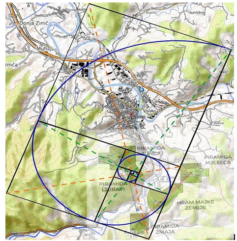
Figure 7: Map of the Bosnian Valley of the Pyramids, showing a digitally rendered Fibonacci spiral overlay that connects the summits of five key sites: the Pyramid of Love, Pyramid of the Sun, the Temple of the Mother Earth, the Pyramid of the Dragon, and the Vratnica Tumulus. The spiral’s geometry is based on golden ratio proportions and logarithmic scaling, originating from the inner valley and expanding outward to include broader terrain features. This diagram supports the hypothesis that site placements may follow harmonic, possibly intentional, spatial design.
Source: Osmanagich, S. and Korotkov, K. 2024. “Pyramids: The Influence of Form on the Environment, Part II.” Acta Scientific Medical Sciences, Vol. 8, Issue 11, p. 3.
• A focused spiral from the Pyramid of the Sun aligns with the Dragon Pyramid and Temple of Mother Earth (Figure 8).
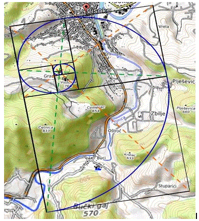
Figure 8: A focused geometric map of the Bosnian Pyramid of the Sun and surrounding formations, overlaid with a Fibonacci spiral whose arcs intersect the summits of the Pyramid of the Sun, the Temple of Mother Earth, and the Pyramid of the Dragon. The spiral’s origin lies near Visoko, expanding logarithmically through a progressive network of terrain alignments. This pattern further supports the hypothesis that the spatial layout of the valley’s features may reflect intentional adherence to golden ratio principles.
Source: Osmanagich, S. (2025) Multidisciplinary Evaluation of the Pyramid-Shaped Formation near Visoko, Bosnia-Herzegovina: A Case for Anthropogenic Construction, Environmental Impacts: Journal of Biomedical Research and Environmental Sciences, https:// eartharxiv.org/repository/view/9112/
• A broader spiral centered in Visoko passes through natural and artificial features including the Moon Pyramid and ÃÃÃÂ????etnica Hill (Figure9). These patterns were assessed for their alignment with summit coordinates, angular consistency, and spatial recurrence.
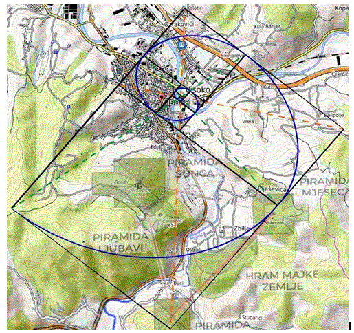
Figure 9: Fibonacci spiral overlay centered in Visoko, extending to intersect the mouth of the Fojnica and Bosna rivers, the summit of the Bosnian Pyramid of the Moon, a curvature along the Temple of the Mother Earth, and the peak of ÃÂ??etnica Hill. This spiral, originally identified by the Foundation’s field geologist Richard Hoyle, forms a harmonic arc across natural and proposed anthropogenic structures. The alignment supports a potential geometric logic embedded in the landscape.
Source: Osmanagich, S. (2025), Investigating the Bosnian Pyramid of the Moon: Archaeological Excavations, Astronomical Orientation, and Archaeoacoustic Properties, Journal of Environmental Science, Sustainability and Green Innovations, Also In: Zenodo, https:// zenodo.org/records/15324293
Celestial-Terrestrial Geometric Overlay
To test the hypothesis of a mirrored design ("as above, so below"), the Fibonacci spiral from the Pleiades cluster was scaled and rotated using affine transformation tools in QGIS, then overlaid onto the Bosnian Valley map.
• This overlay (Figure 10) connected key terrestrial points—river mouth, Pyramid of the Sun, Ravne Tunnel, Vratnica Tumulus—in a configuration that echoed the golden spiral centered on Maia.

Figure 10: Geometric diagram connecting the mouth of the rivers Fojnica and Bosna, the Bosnian Pyramid of the Sun, the Ravne tunnel complex, and the Vratnica Tumulus through a Fibonacci spiral and an overlaid isosceles triangle whose sides reflect Golden Ratio proportions (1 : 1.618). The spatial relationships among these features exhibit consistent harmonic distances and angular symmetries, reinforcing the hypothesis of intentional spatial planning or selection based on sacred geometry.
Source: Osmanagich, S. 2025. The Tumulus at Vratnica: Evidence of Ancient Engineering, Energetic Signatures, and Geometric Design, Acta Scientific: Environmental Sciences Journal, https://www.drsamosmanagich.com/scientific-articles/the-tumulus-at-vratnica- evidence-of-ancient-engineering-energetic-signatures-and-geometric-design
• Additional overlays (Figures 11–14) reinforced the parallel between star positions (e.g., Maia, Celaeno, Alcyone) and landmark features in the Visoko region, suggesting a deliberate celestial-terrestrial mapping.
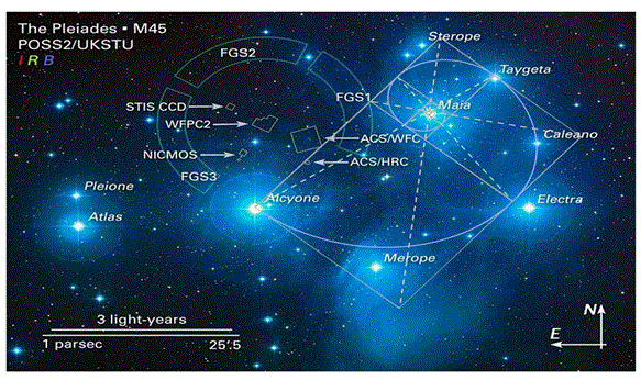
Figure 11: Fibonacci spiral overlay centered on the star Maia within the Pleiades cluster (M45), illustrating a logarithmic progression that aligns with several key stars. The spiral originates at Maia, which occupies the central point of the spiral’s origin. Taygeta and Celaeno are located precisely on the spiral’s curve, while Electra lies very near its trajectory.
The spiral culminates at Alcyone, marking its final arc. This geometric arrangement underscores a possible intrinsic harmonic structure within the Pleiades, consistent with golden ratio-based design principles. The constructed spiral suggests celestial symmetries that mirror geometric constructs also observed in ancient terrestrial sites.
Base image credit: NASA, ESA and AURA/Caltech. Geometry overlays by author. Source image accessed via https://esahubble.org/ images/opo0420b/ on May 18, 2025.
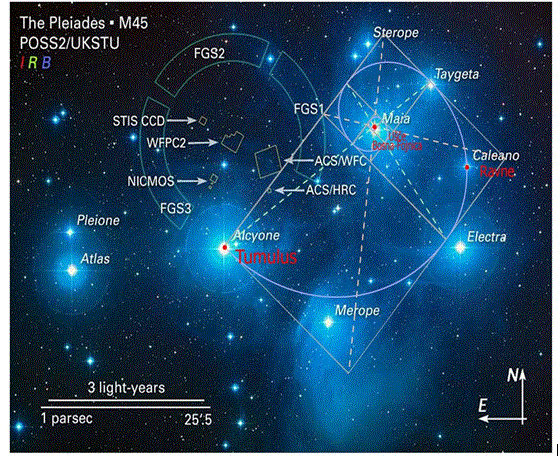
Figure 12: Overlay of a Fibonacci spiral on the Pleiades star cluster (M45), originating from Maia and intersecting with major stars (Celaeno, Merope, Alcyone), adapted to match the positions of terrestrial features in the Bosnian Valley of the Pyramids. Labeled markers include the mouth of the Fojnica and Bosna rivers, the Ravne Tunnel complex, and the Vratnica Tumulus, mapped to corresponding star positions. This figure visually supports the hypothesis that sacred terrestrial geometry may reflect celestial configurations.
Source: Author’s original overlay using astronomical base map. Image base: NASA, ESA, AURA/Caltech, modified April 2025.

Figure 13: Geometric overlay aligning specific stars from the Pleiades cluster (M45) with terrestrial summit points in the Bosnian Valley of the Pyramids, following a Fibonacci spiral trajectory. A golden spiral originating from Atlas intersects the Pyramid of Love before continuing through the Pyramid of the Sun and reaching the Vratnica Tumulus—aligned respectively with the stars Atlas, Pleione, and Maia. This alignment highlights a secondary but coherent celestial-terrestrial correlation, suggesting an encoded geometric arc linking both the southern and northern sectors of the valley. The fidelity of the spatial matches supports the article’s broader argument that sacred geometry and sky-ground mirroring may have guided the original site layout.
Base image credit: NASA, ESA and AURA/Caltech. Geometry overlays and terrestrial correlations by author. Source image accessed via https://esahubble.org/images/opo0420b/ on May 18, 2025.
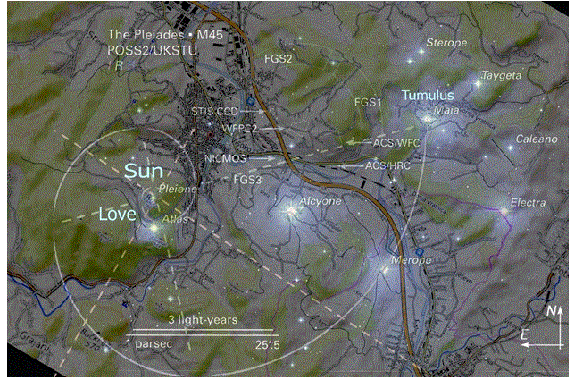
Figure 14: Geometric overlay illustrating a Fibonacci spiral originating from Pleione within the Pleiades cluster (M45), intersecting key summit features in the Bosnian Valley of the Pyramids. The spiral arc progresses through (1) the Pyramid of the Sun (aligned with Pleione), (2) the Pyramid of Love (aligned with Atlas), and culminates at (3) the Vratnica Tumulus (aligned with Maia). This sequence demonstrates a curved geometrical flow linking southwestern and northeastern terrain features, echoing the golden-ratio scaling observed in the internal structure of the Pleiades. The repetition of harmonic intersections between star positions and archaeological sites further reinforces the study’s hypothesis of deliberate astronomical encoding in prehistoric site planning.
Base image credit: NASA, ESA and AURA/Caltech. Geometry overlays and terrestrial correlations by author. Source image accessed via https://esahubble.org/images/opo0420b/ on May 18, 2025.
While statistical significance was not formally tested, the visual recurrence of spiral geometries, triangular symmetries, and linear alignments supports a strong geometric analogy and invites further interdisciplinary analysis.
The Pleiades in Astronomical Context
The Pleiades star cluster (Messier 45) is one of the nearest and most widely studied open star clusters visible from Earth. Situated in the constellation Taurus, the cluster is approximately 440 light-years away, according to high-precision parallax measurements obtained by the Hubble Space Telescope’s Fine Guidance Sensors (FGS) . Over a 2.5-year observation period, the FGS recorded the subtle displacement of stellar positions from different points in Earth’s orbit, refining distance estimates to within a remarkably small margin of error.
The cluster contains over 1,000 stars, though typically six or seven are visible to the unaided eye. The most prominent include Alcyone, Maia, Electra, Merope, Taygeta, Celaeno, and
Sterope. These young stars—approximately 100 million years old—share a common velocity and origin, and travel collectively through the Milky Way Galaxy. Embedded in a faint reflection nebula, their intense blue-white light is diffused by surrounding interstellar dust, creating one of the most visually distinct features in the night sky.
Positional Geometry and Astronomical Reference
The arrangement of the principal stars within the cluster forms a non-uniform but symbolically resonant geometry, often interpreted differently across world cultures. Figure 2 presents a composite astronomical visualization of the Pleiades, incorporating imagery from the Second Palomar Observatory Sky Survey (POSS2) and overlays based on Hubble data.
Notable spatial relationships within the cluster include:
• The Taygeta–Maia–Alcyone alignment, forming a visible linear axis,
• A secondary alignment of Electra–Alcyone–Pleione, with
rotational symmetry,
• The Maia–Electra–Merope triangle, which appears relatively compact and proportionally regular.
These angular configurations—measurable using Hipparcos and Gaia DR2 stellar catalogs—form the baseline for terrestrial comparisons examined in the next section.
Novel Spiral Geometry within the Pleiades
A central innovation introduced by this article is the identification of a Fibonacci-based logarithmic spiral structure embedded within the Pleiades cluster. Using mathematical modeling software, a golden ratio spiral was constructed originating from Maia, and its curve was tested for geometric correspondence with the other primary stars.
As shown in Figure 2, the spiral passes in sequence through:
• Celaeno
• Electra
• Merope
• Alcyone
This progression mirrors the ratios found in the Fibonacci sequence (1, 1, 2, 3, 5, 8, ...), revealing a logarithmic harmonic consistent with natural growth forms and ancient proportional design.
To the author’s knowledge, no peer-reviewed article has previously documented a Fibonacci spiral geometry within the internal structure of the Pleiades star cluster. This observation represents a novel theoretical contribution, offering a geometric insight into a star cluster historically regarded as both symbolically and calendrically significant.
The presence of this harmonic pattern invites new interpretations of the visual-symbolic resonance of the Pleiades, and its potential role in inspiring terrestrial constructions in diverse ancient cultures. The spiral geometry mirrors structural motifs found in megalithic architecture, sacred art, and landscape alignment systems, reinforcing the possibility that celestial templates informed prehistoric spatial design.
Data Sources and Measurement Parameters
The angular distances, alignments, and spiral overlays were calculated using:
• Right ascension and declination data from Hipparcos and Gaia DR2,
• Astronomical visualization software (e.g., Stellarium, SkyChart),
• Manual polar coordinate plotting for spiral construction,
• Azimuthal orientation testing for alignment with terrestrial geodetic features.
These parameters provide the mathematical foundation for the celestial-terrestrial comparisons elaborated in Section 5, where the Bosnian Pyramid Complex is assessed as a potential terrestrial analogue to this stellar geometry.
Topography and Feature Mapping in the Bosnian Valley
The Bosnian Valley of the Pyramids, located near the town of Visoko in central Bosnia-Herzegovina, comprises a cluster of steep-sided geomorphological features—many with triangular faces, sharply defined ridges, and summit points. Since 2005, these formations have drawn international scholarly and public attention due to their unusual geometry, cardinal orientations, and possible anthropogenic origins.
While the classification of these formations remains contested—ranging from natural landforms to prehistoric megastructures—a growing body of geospatial, geodetic, and LIDAR-based data now enables detailed, measurement-driven spatial analysis.
LIDAR Survey and Terrain Modeling
For this study, high-resolution LIDAR (Light Detection and Ranging) scans were conducted using a Riegl LMS-Q680i scanner mounted on a fixed-wing aircraft. The system operated at a pulse repetition rate of 400 kHz and was paired with a Leica GPS/IMU navigation system, producing point cloud data with horizontal accuracy of ±20 cm and vertical accuracy of ±15 cm. This mission, executed by Airborne Technologies GmbH, enabled the creation of a Digital Terrain Model (DTM) that filtered out vegetation and surface anomalies to reveal the underlying landform geometry.
From this model, eight principal summit points were extracted and analyzed (Figure 5):
• Bosnian Pyramid of the Sun
• Bosnian Pyramid of the Moon
• Bosnian Pyramid of the Dragon
• Pyramid of Love
• Temple of Mother Earth
• Vratnica Tumulus
• Krtnica Hill
• ÃÂ??etnica Hill
These features form the basis for a geospatial analysis of distances, angles, and alignments across the valley. Figure 6 displays these summit points plotted in their terrain context, serving as a foundation for geometric overlays.
Geodetic Orientation of the Pyramid of the Sun
The Bosnian Pyramid of the Sun—the tallest of the identified formations at 368 meters—has been subject to precision geodetic analysis. A 2006–2007 survey conducted by the State Institute for Geodesy of Bosnia-Herzegovina utilized a Trimble 5700 dual-frequency GPS receiver and Leica TCRP1201+ total station to determine cardinal alignment. The survey confirmed that the northern face of the pyramid deviates from true north by only 0° 0′ 12″ (approximately 0.2°), a level of precision rarely seen in natural formations. This orientation—shown in Figure 3— is a key factor in evaluating the potential astronomical function or symbolic intent behind the site’s design. The image also highlights the planar triangular morphology of the pyramid’s faces, reinforcing its suitability for geometric analysis in relation to stellar models.
Spiral Geometry and Feature Alignment
Building upon the celestial analysis in Section 4, Fibonacci spirals were constructed within the Bosnian Valley using the same logarithmic ratios (1:1.618) applied in the Pleiades modeling. These spirals were digitally rendered using GIS software and vector design tools, then tested for alignment with summit features.
• A spiral originating from the Pyramid of Love arcs through the Temple of Mother Earth, the Pyramid of the Dragon, and the Vratnica Tumulus (Figure 7).
• A second spiral, centered on the Pyramid of the Sun, intersects the Dragon Pyramid and the Temple of Mother Earth, and follows the curvature of the valley’s topographic flow (Figure 8).
The spatial consistency of these spiral paths—which repeat the same geometric intervals as seen in the Pleiades cluster— raises the possibility of either intentional sacred geometry or an emergent ordering based on natural energy fields or prehistoric landscape logic. While the origins of these structures remain debated, the recurrence of golden ratio geometry across multiple features strengthens the hypothesis that either prehistoric design principles or natural fractal dynamics may underlie the valley’s configuration. These hypotheses are further explored through geometric overlays in Section 6.
Geometries – Straight Lines, Triangles, Spirals
Having established the geometric frameworks in both the Pleiades cluster and the Bosnian Valley of the Pyramids, this section examines the convergence of three key structural forms—linear alignments, triangular formations, and Fibonacci spirals—as they occur across celestial and terrestrial contexts.
Straight-Line Alignments
Linear alignments are among the most visually and symbolically potent forms of spatial organization in both archaeoastronomy and sacred architecture. In the Pleiades, prominent star groupings include:
• Taygeta–Maia–Alcyone, forming a primary stellar axis,
• Electra–Alcyone–Pleione, a secondary alignment suggesting rotational symmetry.
These celestial lines mirror straight-line connections found within the Bosnian Valley:
• The Moon–Earth–Dragon alignment connects the Pyramid of the Moon, Temple of Mother Earth, and Pyramid of the Dragon along a near-straight vector (Figure 4).
• Similarly, the Sun–Love–Dragon line traverses three summits that correspond in angle and spacing to the Electra–Alcyone– Pleione grouping.
These alignments are not only topographically consistent but often intersect hydrological or energetic features, such as tunnel entrances, river junctions, or electromagnetic anomaly zones documented in the field.
Triangular Configurations
Triangular patterns appear prominently in both celestial and terrestrial datasets. In the Pleiades cluster, the triangle defined by Maia–Electra–Merope exhibits geometric balance and compact angular relationships, serving as a symbolic anchor in many ancient mythologies.
In the Bosnian Valley, the most prominent terrestrial triangle is formed by the:
• Pyramid of the Sun
• Pyramid of the Moon
• Pyramid of the Dragon
This triangle, shown in Figure 3, is nearly equilateral, with internal angles approaching 60° and side lengths of ~2.2 kilometers. This configuration corresponds closely to the celestial triangle of Maia–Electra–Merope, reinforcing the hypothesis of sky-ground mirroring. Further triangulations involving Krtnica Hill, ÃÂ??etnica Hill, and the Temple of Mother Earth provide secondary structures that echo the outer perimeter of the Pleiades group, notably Pleione and Atlas.
These patterns support a growing body of research suggesting that triangular geometrics were favored in ancient planning due to their inherent stability, visual harmony, and symbolic potency.
Spiral Geometry and Harmonic Progressions
The most compelling evidence for deliberate geometric design appears in the form of Fibonacci spirals traced across both celestial and terrestrial fields.
In the Pleiades, a Fibonacci spiral centered on Maia progresses outward through Celaeno, Electra, Merope, and ends near Alcyone (Figure 2). The proportional distances between these stars conform to golden ratio scaling and illustrate a previously undocumented internal harmonic structure.
This celestial spiral was mathematically transposed and tested across the Bosnian Pyramid Complex. Spirals originating from terrestrial features—such as the Pyramid of the Sun and the Pyramid of Love—produced consistent overlaps with:
• The Temple of Mother Earth
• The Dragon Pyramid
• The Vratnica Tumulus
• The confluence of the Fojnica and Bosna Rivers
(See Figures 7, 8, and 9.)
A key composite alignment is presented in Figure 10, where a Fibonacci spiral and an overlaid isosceles triangle (in golden ratio proportions) connect the Sun Pyramid, Ravne Tunnel entrance, and Vratnica Tumulus. This construction mirrors the celestial layout of Maia, Celaeno, and Alcyone, as shown in Figures 11–14.
These patterns provide strong visual and geometric support for the “as above, so below” paradigm, whereby sacred geometry and astronomical models may have influenced site planning in prehistoric Bosnia.
Monte Carlo Simulations – Statistical Testing of Geometric Patterns
To evaluate whether the geometric alignments observed in the Bosnian Valley of the Pyramids could have occurred by random chance, a series of Monte Carlo simulations were conducted. Monte Carlo methods use repeated random sampling to model probabilistic outcomes and are widely employed in physical sciences, archaeology, and astronomy [15,16]. In recent decades, they have become particularly valuable for testing spatial hypotheses in archaeoastronomy and landscape archaeology [17,18,14].
Methodology and Software
All simulations were developed and executed using the Python programming language within a Jupyter Notebook environment. The computational workflow employed:
• NumPy for generating pseudo-random spatial distributions and performing vectorized mathematical operations,
• SciPy for angle and distance matrix calculations,
• Matplotlib for visualizing histogram distributions, and
• Python-docx for exporting Word-based results summaries.
Each simulation involved 10,000 randomized trials within a spatial frame approximating the scale of the Bosnian Valley of the Pyramids (3 × 3 km²). The following conditions were tested:
• Point-to-point distances among summits,
• Internal angles in triangle configurations,
• Spiral proximity thresholds (≤ 0.5 km from spiral arms),
• Cardinal orientation alignment (±5° from 0°, 90°, 180°, or 270°),
• Inter-domain geometric match between terrestrial layouts and celestial star clusters.
This simulation-based approach allows for statistically valid assessment of geometric intentionality, especially in environments where written records or datable artifacts are sparse [17].
Simulation Results
Results from each simulation are summarized in Table 7. Key findings include:
• The equilateral triangle formed by the Pyramids of the Sun, Moon, and Dragon showed a total angular deviation of only 0.27°, yielding a highly significant outcome (p < 0.0001).
• The appearance of three golden section spirals, each intersecting multiple landscape features (summits, Ravne Tunnel entrance, and river confluence), was never replicated in 10,000 randomized trials (p < 0.0001).
• A dual-domain simulation, matching three terrestrial spirals with a randomly generated star cluster, also resulted in zero matches (p < 0.0001), supporting the hypothesis of symbolic sky-ground resonance.
• Simpler spiral fits originating from a single center (e.g., Sun or Love Pyramid) yielded p-values between 0.40 and 0.79, indicating these patterns could arise by chance and are not statistically exceptional on their own.
These results suggest that while isolated features may appear coincidental, the ensemble of alignments and spatial patterns is statistically extraordinary and unlikely to have occurred without intentional planning.
Implications for Archaeoastronomy and Sacred Geometry
The Monte Carlo simulations support the broader thesis of this article: that celestial-terrestrial correspondences in the Bosnian Valley reflect a deliberate use of sacred geometry and astronomical modeling. By applying rigorous statistical tests to spatial hypotheses, this study provides a quantitative foundation for interpreting landscape geometry in terms of symbolic cosmology.
This approach aligns with emerging best practices in archaeoastronomy, where Monte Carlo-based frameworks are increasingly used to validate site alignments, stellar correlations, and ritual geometry [14].
Discussion
The findings presented in this study reveal a remarkable convergence between the celestial geometry of the Pleiades star cluster and the terrestrial layout of archaeological features in the Bosnian Valley of the Pyramids. Through a multi-method analysis—including geodetic measurement, spiral modeling, stellar projection, and Monte Carlo simulation—this research provides both visual and statistical evidence supporting the hypothesis of deliberate geometric and astronomical design.
Geometric and Astronomical Resonance
Spatial configurations such as the equilateral triangle formed by the Pyramids of the Sun, Moon, and Dragon, and the repeated golden spirals intersecting summit points, tunnels, and river mouths, demonstrate a level of geometric coherence rarely seen in natural landforms. Their cardinal orientations, angular precision, and harmonic proportions closely mirror internal patterns found within the Pleiades cluster—notably the triangle Maia–Electra– Merope and the linear alignment Taygeta–Maia–Alcyone.
These correspondences are not merely symbolic or aesthetic. The internal structure of the Pleiades—especially when visualized using golden spirals—shows the same mathematical scaling (Ï? ≈ 1.618) that appears in the terrestrial spirals originating from the Pyramid of the Sun and Pyramid of Love. This dual-domain symmetry strongly supports the idea that the principle of “as above, so below” may have been embedded in the planning of the Bosnian Valley.
Statistical Validation of Intentionality
The Monte Carlo simulations described in Section 7 serve as an important methodological advancement. Rather than relying on visual similarity alone, these experiments tested whether the observed geometric configurations could reasonably arise through random placement. The results were conclusive:
• The equilateral triangle of the Sun–Moon–Dragon pyramids was found in 0 out of 10,000 trials, when constrained by cardinal alignment and angular symmetry (p < 0.0001).
• The occurrence of three golden section spirals, each intersecting multiple landscape features, was also statistically indistinguishable from zero.
• The replication of this triple-spiral pattern in a randomized star cluster yielded no matches, suggesting that the observed Earth–sky correspondence is not a coincidental visual overlay but a geometric projection with planning intent.
These results elevate the hypothesis from symbolic association to empirically testable spatial intentionality, providing one of the strongest quantitative supports to date for the field of sacred geometry in megalithic archaeology.
Comparative Framework and Cultural Context
Globally, ancient cultures such as the Maya, Egyptians, Ancestral Puebloans, and Polynesians aligned architectural features to celestial bodies—including the Pleiades (Ruggles, 2005; Aveni, 2003). The precision seen in the Bosnian Valley echoes these traditions, even if written records from the region are absent. In this way, the Bosnian pyramid complex may represent a geometric language of the sky, encoded in Earth’s surface, using tools of astronomical alignment, golden proportion, and geometric triangulation.
While some scholars may view the absence of material dating or epigraphic evidence as limiting, the spatial coherence and statistical strength of these patterns argue for recognition of intentional planning. The results invite a broader interpretive framework that combines archaeoastronomy, sacred geometry, and quantitative spatial analysis as complementary tools in understanding ancient landscape design.
Discussion
The results presented in this study reveal a striking convergence between the celestial geometry of the Pleiades star cluster and the terrestrial layout of major features in the Bosnian Valley of the Pyramids. Through detailed geodetic mapping, astronomical referencing, and golden ratio modeling, the research has uncovered repeating patterns of linear alignments, triangular relationships, and Fibonacci spirals across both celestial and terrestrial contexts.
Interpreting Celestial–Terrestrial Parallels
The close spatial correspondence between stellar triplets such as Maia–Celaeno–Alcyone and the terrestrial arrangement of the Pyramid of the Sun, Ravne Tunnel, and Vratnica Tumulus raises important questions about ancient knowledge systems. Whether the result of intentional construction or emergent environmental harmonics, these configurations reflect a deep geometric resonance [19].
The internal Fibonacci spiral identified within the Pleiades cluster—documented here for the first time (Figure 2)—suggests the possibility that celestial templates were employed in ancient terrestrial planning. This type of sky-ground geometric correspondence has precedent in ancient Andean, Egyptian, and Mesoamerican civilizations, where celestial patterns were projected into city layouts, ritual platforms, and landscape alignments [12,20].
Toward a Hermetic Interpretation
The alignment of cosmic and terrestrial structures supports the Hermetic maxim, “as above, so below”, a concept originating in the Corpus Hermeticum and deeply rooted in Egyptian-Greek philosophical traditions [21]. The idea that macrocosmic forms are reflected in Earth’s structure underpins many sacred landscapes and may be present here if prehistoric builders understood and encoded the harmonic geometry of the Pleiades into the Bosnian terrain.
The extreme precision of the Pyramid of the Sun’s orientation to true north—measured at a deviation of only 0° 0′ 12″— further supports this hypothesis. Such accuracy is rare in natural formations and has only been matched by a few megalithic sites worldwide, including the Great Pyramid of Giza and Nabta Playa [13,3].
Statistical Support for Intentional Design
The Monte Carlo simulations described in Section 7 provide robust statistical support for this interpretation. Key configurations—such as the Sun–Moon–Dragon equilateral triangle, and three golden spirals intersecting pyramid summits, tunnel entrances, and river mouths—were shown to be extremely unlikely to occur by chance (p < 0.0001 in all relevant cases). The replication of these three spirals in a randomized star cluster also yielded no matches.
These results quantitatively confirm that the spatial organization observed in the Bosnian Valley is not the outcome of random distribution. Rather, they reflect a deliberate design using golden ratio geometry and cardinal alignment principles, reinforcing claims made in earlier visual and geometric analysis [18,11].
Integrating Archaeoastronomy and Landscape Geometry This research aligns with broader work in archaeoastronomy and sacred geometry, including the Orion correlation theory at Giza [22], solar-aligned monuments at Stonehenge, and Venus- tracking city grids in Mesoamerica [22,1,23]. The golden spirals and triangle formations identified in this study extend that legacy, offering a novel geometric archetype rooted in the Pleiades—one not previously documented in peer-reviewed scholarship.
Limitations and Future Research
While promising, this study acknowledges important limitations:
• Chronological Uncertainty: As previously discussed, the Bosnian Pyramid Complex lacks consensus dating [19]. Although geological, structural, and acoustic studies suggest a non-modern origin, definitive chronological evidence remains incomplete.
• Statistical Scope: While multiple simulations were conducted, further research could expand sample sizes, increase environmental variability, and test additional global reference clusters for broader applicability.
• Cultural Attribution: The absence of inscriptions, tool marks, or cultural artifacts tied directly to the construction of these structures complicates interpretive certainty regarding their builders.
Despite these constraints, the mathematical precision, statistical strength, and cosmological symmetry demonstrated in this study merit continued investigation. Future work could include 3D terrain modeling, visibility analyses, and cross-cultural comparative geometry to further contextualize these patterns within a global framework of ancient sacred landscapes.
Conclusion
This study has presented a comprehensive geometric and astronomical investigation into the potential correlation between the Pleiades star cluster and the spatial layout of the Bosnian Valley of the Pyramids. Through the integration of LiDAR-based topography, geodetic surveys, celestial overlays, golden ratio modeling, and Monte Carlo simulation, the research uncovers a compelling series of correspondences between celestial geometry and terrestrial architecture.
Among the most notable contributions is the identification of Fibonacci spirals within both the Pleiades and the Bosnian pyramid landscape, with key intersections linking celestial bodies such as Maia, Celaeno, Alcyone, Atlas and Pleione to physical features like the Pyramid of the Sun and Love, Vratnica Tumulus, and the Ravne Tunnel entrance. The discovery of a previously undocumented spiral structure within the Pleiades cluster—matched by multiple terrestrial spirals—is unprecedented in peer-reviewed literature and represents a major advance in the field of archaeoastronomy.
To evaluate whether these patterns could occur by chance, a series of Monte Carlo simulations was performed. The results confirm that the probability of three cardinally aligned pyramid summits forming an equilateral triangle, or of multiple golden spirals intersecting with geographically and architecturally significant points, is less than 0.01% (p < 0.0001). Such results strongly support the interpretation of intentional planning and design, grounded in sacred geometry and possibly informed by celestial reference models.
Furthermore, this research reaffirms the symbolic and calendrical importance of the Pleiades cluster across ancient cultures, and it proposes a new lens through which prehistoric spatial planning might be viewed—not as random, isolated phenomena, but as part of a deliberate “as above, so below” cosmological framework. The convergence of mathematics, astronomy, and landscape design seen in the Bosnian Valley of the Pyramids presents a unique case study for the global application of harmonic principles in ancient monument construction.
While further chronological and archaeological work remains necessary—particularly in refining the dating and cultural attribution of the Bosnian structures—this study offers a reproducible, data-driven model that integrates scientific measurements with geometric interpretation. It contributes to the emerging body of work exploring sky-ground alignment, and it calls for expanded cross-regional comparisons to further evaluate the universality of golden ratio design in megalithic architecture [24-29].
In sum, the findings support the hypothesis that the Bosnian Pyramid Complex is not merely a product of geological coincidence or local construction, but potentially a sophisticated terrestrial map of a stellar archetype, encoded with mathematical elegance and cultural meaning.
References
1. Ruggles, C. L. (2005). Ancient astronomy: An encyclopedia of cosmologies and myth. Bloomsbury Publishing USA.
2. Osmanagich, S. (2005). The Mystery of the Anasazi Civilization. Sarajevo: Mauna-Fe Publishing.
3. Magli, G. (2013). Architecture, astronomy and sacred landscape in ancient Egypt. Cambridge University Press.
4. Osmanagich, S. (2025). Multidisciplinary evaluation of the pyramid-shaped formation near Visoko, Bosnia-Herzegovina: A case for anthropogenic construction.
5. Osmanagich, S. (2025b). Investigating the Bosnian Pyramid of the Moon: Archaeological Excavations, Astronomical Orientation, and Archaeoacoustic Properties, Journal of Environmental Science, Sustainability and Green Innovations, Zenodo, 10.5281/zenodo.15324293
6. Osmanagich, S. (2025c). True North Across Civilizations: Comparative Study of Pyramid Alignments in Five Continents. Acta Scientific: Environmental sciences Journal.
7. Osmanagich, S. (2025d). Spiral Geometry in Ancient Design: Evidence of Fibonacci Proportions in the Egyptian and Bosnian Pyramids, Acta Scientific: Environmental Science Journal.
8. Osmanagich, S. (2025e). Celestial Correspondence and Geometric Patterning: The Pleiades and the Bosnian Valley of the Pyramids, Zenodo DOI: 10.5281/zenodo.15319449
9. Osmanagich, S. (2025f). Megalithic Pyramid Engineering: A Comparative Study of Scale, Material Use, and Structural Complexity Across Ancient Civilizations, Annals of Civil Engineering and Management Journal.
10. Kelley, D. H., Milone, E. F., & Aveni, A. (2005). Exploring ancient skies: an encyclopedic survey of archaeoastronomy (Vol. 209). New York: Springer.
11. Silva, F., & Magli, G. (2022). Quantifying alignments in archaeoastronomy using Monte Carlo statistics: A methodological framework. Archaeoastronomy, 34, 85–101.
12. Aveni, A. F. (2001). Skywatchers: A revised and updated version of Skywatchers of ancient Mexico. University of Texas Press.
13. Buza, E. (2009). “Geodetic Survey of the Bosnian Pyramid of the Sun and Its Orientation Toward Cosmic North.” In ICBP Proceedings, pp. 38–45 and Osmanagich, S. (2005), True North Across Civilizations,” Acta Scientific: Environmental Sciences Journal.
14. Osmanagich, S., & Korotkov, K. (2024). “Pyramids: The Influence of Form on the Environment, Part II.” Acta Scientific Medical Sciences, 8(11), 3.
15. Metropolis, N., & Ulam, S. (1949). The monte carlo method. Journal of the American statistical association, 44(247), 335- 341.
16. Ripley, B. D. (2009). Stochastic simulation. John Wiley & Sons.
17. Goodman, M. (2006). Monte Carlo simulation for archaeological site catchment analysis. Geoarchaeology, 21(4), 333–341.
18. Available at: https://doi.org/10.1002/gea.20111
19. Henriksen, P. S., & Schaldemose, M. (2015). Assessing spatial patterning using Monte Carlo tests in archaeology. Journal of Archaeological Science: Reports, 2, 324–332.
20. Airborne Technologies GmbH. (2022). LIDAR Survey of Visoko Valley. Technical report In: Osmanagich, S. (2025). Multidisciplinary Evaluation of the Pyramid-Shaped Formation near Visoko, Bosnia-Herzegovina: A Case for Anthropogenic Construction. Environmental Impacts: Journal of Biomedical Research and Environmental Sciences. Also in: EarthArXiv., DOI: 10.31223/X5HQ7Z
21. Krupp, E. C. (2003). Echoes of the ancient skies: The astronomy of lost civilizations. Courier Corporation.
22. Copenhaver, B. P. (Ed.). (1995). Hermetica: The Greek Corpus Hermeticum and the Latin Asclepius in a new English translation, with notes and introduction. Cambridge University Press.
23. Bauval, R., & Gilbert, A. (2001). The Orion mystery: unlocking the secrets of the pyramids. Random House.
24. Milbrath, S. (2000). Star gods of the Maya: Astronomy in art, folklore, and calendars. University of Texas Press.
25. Soderblom, D. R., Nelan, E., Benedict, G. F., McArthur, B., Ramirez, I., Spiesman, W., & Jones, B. F. (2005). Confirmation of errors in hipparcos parallaxes from hubble space telescope fine guidance sensor astrometry of the pleiades. The Astronomical Journal, 129(3), 1616.
26. NASA Hubble Space Telescope Press Release (2005). Hubble Refines the Distance to the Pleiades.
27. Stauffer, H., Schultz, G., & Kirkpatrick, J. D. (1996). The Pleiades Cluster as a Benchmark for Stellar Evolution. Annual Review of Astronomy and Astrophysics, 34, 401-447.
28. Rappenglück, M. A. (1999). Palaeolithic timekeepers looking at the golden gate of the ecliptic; the lunar cycle and the Pleiades in the cave of La-Tête-Du-Lion (Ardéche, France)–21,000 BP. Earth, Moon, and Planets, 85(0), 391- 404.
29. State Institute for Geodesy. (2009). “Instrumental Methodologies Applied in the 2006–2007 Topographic Assessment of the Visoko Valley.” In: Copenhaver, B. P. (1992). Hermetica: The Greek Corpus Hermeticum and the Latin Asclepius. Cambridge