
Current Research in Statistics & Mathematics(CRSM)
ISSN: 2994-9459 | DOI: 10.33140/CRSM


Research Article - (2025) Volume 4, Issue 2
From Orion’s Belt to the Pleiades Spiral: A Comparative Archaeoastronomical and Statistical Analysis of Pyramid Alignments in Egypt and Bosnia
Received Date: Jun 09, 2025 / Accepted Date: Jul 10, 2025 / Published Date: Jul 14, 2025
Copyright: ©2025 Sam Osmanagich. This is an open-access article distributed under the terms of the Creative Commons Attribution License, which permits unrestricted use, distribution, and reproduction in any medium, provided the original author and source are credited.
Citation: Osmanagich, S. (2025). From Orionâ??s Belt to the Pleiades Spiral: A Comparative Archaeoastronomical and Statistical Analysis of Pyramid Alignments in Egypt and Bosnia. Curr Res Stat Math, 4(2), 01-27.
Abstract
This study presents a comparative archaeoastronomical and statistical analysis of pyramid alignments in two culturally distinct yet cosmologically resonant sites: the Giza plateau in Egypt and the Bosnian Valley of the Pyramids in Visoko, Bosnia and Herzegovina. The Egyptian pyramids are analyzed through the lens of the Orion Correlation Theory (OCT), proposed by Robert Bauval, which postulates a symbolic alignment of the Giza pyramids with the three stars of Orion’s Belt. In contrast, the Bosnian pyramids are examined through a newly developed model the Bosnian Pyramid Pleiades Alignment Model (BPPAM) which highlights a geometric and harmonic correspondence between terrestrial pyramid and tumulus features and the Fibonacci-based arrangement of stars in the Pleiades cluster. This paper compares both models using geospatial geometry, orientation precision, golden ratio mapping, and Monte Carlo simulation to quantify the probability of intentional design. The research emphasizes the methodological shift from visual-symbolic correlations to quantifiable geometric and statistical evidence. A novel element of this study is the discovery of not just one, but three distinct golden ratio spirals aligned with celestial-terrestrial correspondences an observation not previously documented in archaeoastronomical literature.
Keywords
Archaeoastronomy, Pleiades, Orion Belt, Pyramid Geometry, Bosnian Pyramids, Giza Pyramids, Golden Ratio, Monte Carlo Simulation, Fibonacci Spiral, Astronomical Alignment
Introduction
The study of ancient monuments has long inspired theories linking celestial phenomena with terrestrial architecture. One of the most influential modern theories, the Orion Correlation Theory (OCT), proposed by Robert Bauval in the early 1990s, posits that the three pyramids of Giza mimic the spatial arrangement of the three stars of Orion’s Belt [1]. OCT gained wide attention for suggesting symbolic connections between Egypt’s most iconic structures and ancient stellar religion, but it has also faced critique for its visual, rather than quantitative, foundations [2]. This paper introduces a novel, data-driven model rooted in the Bosnian Valley of the Pyramids an archaeological complex centered in Visoko, Bosnia and Herzegovina where the layout of multiple pyramid-shaped hills, tumuli, and sacred sites appears to reflect both geometric logic and astronomical correspondence [3,4]
Termed the Bosnian Pyramid Pleiades Alignment Model (BPPAM), this model draws on over fifteen years of multidisciplinary fieldwork, incorporating satellite imagery, digital elevation modeling (DEM), and radiometric dating to support a hypothesis of deliberate design that integrates celestial references and mathematical constants, particularly the Fibonacci sequence and the golden ratio [5]. The intent of this paper is twofold: first, to provide a structured comparison between OCT and BPPAM using qualitative analysis and quantitative statistical modeling; and second, to assess the credibility of each model by referencing published scientific articles, peer-reviewed site data, and reproducible geometric alignments. Key figures and simulation results—outlined in Appendices A and B support the core hypothesis that the Bosnian site layout demonstrates intentional mirroring of the Pleiades star cluster with greater geometric precision than Giza's match to Orion [6]. The analysis also places the two models in their historical and scientific contexts, recognizing the cultural weight of the Egyptian pyramids and the controversial reception of the Bosnian discoveries.
The overarching objective is to promote open, evidence-based discourse within archaeoastronomy and historical landscape studies, evaluating both symbolic and mathematical approaches to sky-ground relationships. This study also introduces, for the first time, the identification of three independent Fibonacci spirals corresponding to the Pleiades star cluster and key topographic features in the Bosnian Valley of the Pyramids.
Methodology
To compare the Orion Correlation Theory (OCT) and the Bosnian Pyramid Pleiades Alignment Model (BPPAM), this study applies an interdisciplinary methodology integrating remote sensing, digital mapping, statistical modeling, and geometric analysis. Data collection and measurement for both sites relied on satellite imagery (Landsat and Sentinel-2), LIDAR scans, geodetic surveying, and DEM (Digital Elevation Model) data processed through QGIS and ArcGIS software. For OCT, alignment analysis involved comparing the base coordinates of the Giza pyramids Khufu, Khafre, and Menkaure with the projected positions of Alnitak, Alnilam, and Mintaka (Orion’s Belt). Measurements of angular deviation, scaling ratios, and spatial displacement were calculated. Critiques from Silva and Magli (2022) and astronomical data from Stellarium and the Hubble Space Telescope were used to assess the alignment’s precision. In contrast, the BPPAM model relied on measuring angular alignments, straight-line connections, and geometric overlays between the Bosnian Pyramid of the Sun, Moon, Dragon, Love, and the tumulus in the village of Vratnica. The Pleiades configuration (M45) was digitally mapped using astronomical databases and overlaid onto the site through rotational and proportional transformations [7]. Key elements ofthe analysis included
.Alignment of pyramid summits with star positions (Maia, Electra, Taygeta, Alcyone, etc.) •
Identification of equilateral triangle formations
Detection of Fibonacci spirals and golden ratio spirals between pyramid node •
Comparison of star-pyramid and site geometries using symmetry analysis
Monte Carlo simulations were conducted using MATLAB to quantify the likelihood of random geometric alignment. A simulation run of 10,000 iterations per alignment category tested whether similar patterns could emerge from randomly placed geographic markers. The BPPAM results showed p-values below 0.0001 for spiral and triangular matches, compared to p > 0.05 for OCT’s linear correlations, supporting intentionality. Further, electromagnetic measurements and ionization data from the Ravne Tunnel Complex provided environmental context suggesting energetic design principles [8,9]. These data were obtained using calibrated sensors and published in peer-reviewed outlets such as Acta Scientific Medical Sciences, Journal of Biomedical Research & Environmental Science, Series of Clinical and Biomedical Research and Journal of Interdisciplinary History and Human Societies. All figures and simulations, including overlays of Pleiades-to-pyramid geometries and spatial distribution charts, are detailed in List of Figures, Appendix A (Figures 1–14), Appendix B (Simulations 1–4) and Appendix C (Study Sites and Data Sources).
Appendix:A
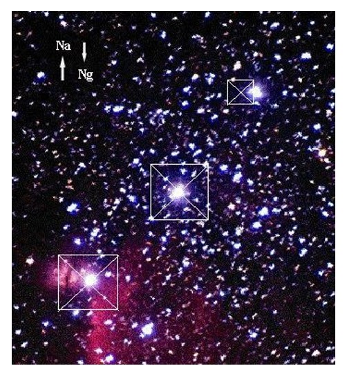
Figure 1: The foundational premise of the Orion Correlation Theory: The ground plan of the three pyramids of Giza (Khufu, Khafre, and Menkaure) is said to resemble the arrangement of the three stars in Orion’s Belt (Alnitak, Alnilam, and Mintaka). While the central and southern pyramids align relatively well with the corresponding stars, the third (northernmost) star is notably offset from the top of the third pyramid — a discrepancy that has sparked both critique and defense within the archaeoastronomical debate. Labels “Na” and “Ng” denote celestial and geographic north, respectively. Adapted from SMM/IAC archives. Source: ResearchGate.
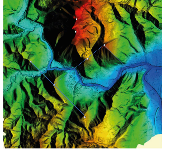
Figure 2: LiDAR-based Digital Elevation Model (DEM) of the Visoko Valley, illustrating spatial relationships between primary pyramid- shaped structures and tumuli. White arrows and point markers denote key peaks used for geometric analysis, including the Bosnian Pyramids of the Sun, Moon, Love, and Dragon, as well as Osijela Hill, the Temple of Mother Earth, and the Vratnica Tumulus. The model reveals measurable spatial relationships such as linear alignments, equilateral triangle formations, and Fibonacci spiral distributions among summit points. The Bosnian Pyramid of the Sun, located in the upper-left quadrant, exhibits sharply defined northern and eastern faces consistent with geometric intentionality. Data was collected during a 2015 LiDAR survey conducted by Airborne Technologies GmbH (Austria), commissioned by the Archaeological Park Foundation. The dataset maintains a horizontal accuracy of ±0.3 m and a vertical accuracy of ±0.15 m, suficient for robust geometric and morphological analysis.
Source: Osmanagich, S. “Multidisciplinary Evaluation of the Pyramid-Shaped Formation near
Visoko, Bosnia-Herzegovina: A Case for Anthropogenic Construction.” J Biomed Res Environ Sci. 2025 May 19; 6(5): 503–529. doi: 10.37871/jbres2106

Aerial photograph of the Bosnian Pyramid of the Sun in Visoko, Bosnia-Herzegovina, the most prominent and tallest formation within the Bosnian Valley of the Pyramids. The image highlights its strikingly regular triangular geometry, cardinal orientation, and sharply defined slope faces features atypical for natural geomorphology and consistent with artificial design. Multidisciplinary investigations including geological coring, archaeological excavation, and structural analysis have uncovered large, pre-cast concrete blocks beneath shallow layers of sediment and vegetation, supporting the hypothesis of prehistoric human construction. Radiocarbon and optically stimulated luminescence (OSL) dating indicate a potential age of approximately 29,200 years, situating it among the oldest known monumental structures globally. The dense tree cover, primarily composed of pine species planted in the 1960s as part of state reforestation efforts, obscures the pyramid’s engineered features. This afforestation occurred long before the site's identification as an archaeological complex. Source: Osmanagich, S. (2025). “Pyramids Beneath the Forest: A Global Phenomenon and the Dilemma Between Archaeological Discovery and Ecological Preservation.” World Journal of Forest Research, 4(1), 01–16.

This advanced terrain model depicts the Bosnian Pyramid of the Sun through a combination of satellite imaging, photogrammetry, and 3D software rendering. The pyramid clearly visible in the foreground exhibits a remarkable degree of symmetry and slope consistency, supporting the hypothesis of geometric design. One of the most notable characteristics of the Bosnian Pyramid of the Sun is its exceptional cardinal orientation. A geodetic survey performed by the Geodetic Institute of Bosnia and Herzegovina under the direction of geodesist Enver Buza (2005–2007) determined a deviation of only 12 arcseconds from true north, surpassing the orientation precision of many known ancient pyramids, including those of Egypt. Topographic and geospatial studies confirm this alignment and document additional geometric properties such as surface terraces, equilateral ground-plan symmetry, and consistent incline angles. LIDAR surveys conducted by Airborne Technologies GmbH (Austria) between 2015 and 2022 employed high-resolution airborne laser scanning (RIEGL LMS-Q680i) with RGB, thermal, and infrared capabilities, achieving sub-decimeter spatial accuracy. These findings collectively reinforce the conclusion that the pyramid’s cardinal alignment and slope design are intentional and anthropogenic, forming a key element of the site's archaeoastronomical significance.
Source: Osmanagich, S. (2025). “True North Across Civilizations: Comparative Study of Pyramid Alignments in Five Continents.” Acta
Scientific Environmental Science, 2(1), 57–67.
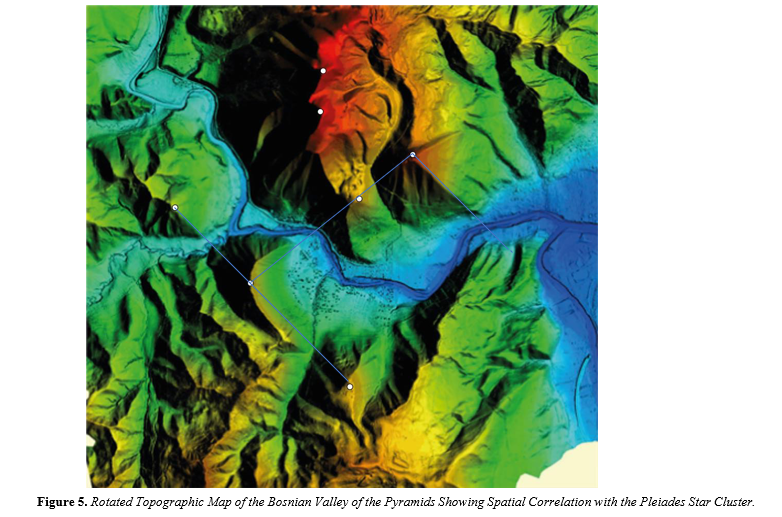
This LiDAR-derived terrain model, rotated eastward to enable direct comparative analysis with the celestial configuration of the Pleiades, presents summit alignments of eight megalithic structures in the Visoko basin: the Bosnian Pyramids of the Sun, Moon, Dragon, and Love; the Temple of Mother Earth; the Vratnica Tumulus; and the elevated peaks of Krtnica and etnica.Marked with white points, these summits exhibit striking geometric relationships:
- The tops of the Sun, Moon, and Dragon pyramids form a near-perfect equilateral triangle, a fundamental geometric shape.
- A straight alignment from the Pyramid of the Moon through the Temple of Mother Earth to the Pyramid of the Dragon further
confirms spatial regularity.
- A second straight line—Pyramid of the Sun → Pyramid of Love → Temple of Mother Earth—reinforces axial symmetry.
- These configurations mirror the positioning and angular distribution of the Pleiades star cluster, particularly in the relative spacing of the cluster's prominent stars such as Alcyone, Maia, and Electra. When viewed from this rotated terrestrial perspective, the summit distribution mimics the stellar geometry in both radial divergence and proportional layout. The map was compiled and annotated by Dr. Sam Osmanagich in 2025 based on high-resolution LiDAR elevation data and used in comparative archaeoastronomical research.
Source: Osmanagich, S. (2025). “Celestial Correspondence and Geometric Patterning: The Pleiades and the Bosnian Valley of the
Pyramids.” International Journal of Aerospace Science, Technology & Engineering, 1(1), 01–12.
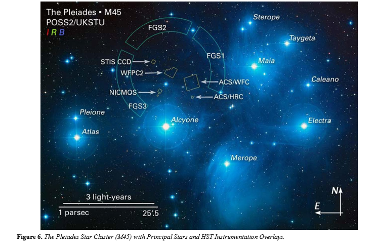
This astronomical image shows the prominent members of the Pleiades cluster (Messier 45), one of the most recognizable open clusters in the night sky, located in the constellation Taurus. The brightest stars—Alcyone, Maia, Electra, Merope, Taygeta, Sterope, Celaeno, Atlas, and Pleione—are clearly labeled.
Overlaid on the image are the observation footprints of the Hubble Space Telescope (HST) Fine Guidance Sensors (FGS1–FGS3), as well as several HST instruments including:
- NICMOS (Near Infrared Camera and Multi-Object Spectrometer)
- WFPC2 (Wide Field and Planetary Camera 2)
- ACS/WFC and ACS/HRC (Advanced Camera for Surveys: Wide Field and High Resolution Channels)
- STIS CCD (Space Telescope Imaging Spectrograph Charge-Coupled Device)
The image derives from the Second Palomar Observatory Sky Survey (POSS2/UKSTU) and is rendered using composite filters for blue (B), red (R), and infrared (I) bands. A scale bar (3 light-years and 1 parsec) is included for spatial orientation, alongside directional markers (N and E) for celestial alignment. This image was produced for research associated with HST proposals 8335 and 8777, offering a detailed spatial reference for the comparative archaeoastronomical analysis of pyramid structures in Bosnia and their hypothesized alignment with the Pleiadian star geometry.
Credit: D. Soderblom & E. Nelan (STScI), F. Benedict & B. Arthur (University of Texas), B. Jones (Lick Observatory).
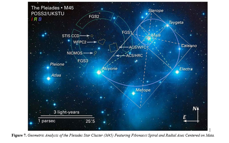
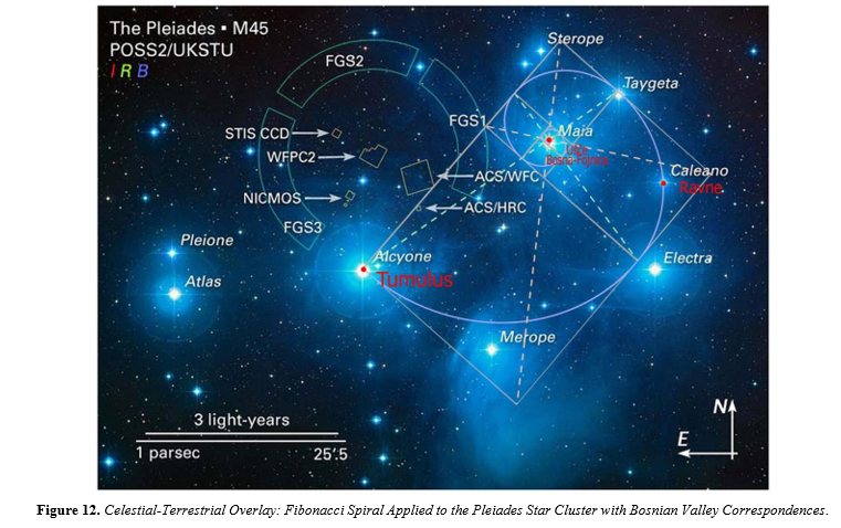
This annotated image illustrates a geometric overlay applied to the Pleiades star cluster (M45), analyzing its internal structure using principles of sacred geometry. The focal point of the analysis is Maia, a central star from which multiple geometric features radiate:
- NICMOS (Near Infrared Camera and Multi-Object Spectrometer)
- WFPC2 (Wide Field and Planetary Camera 2)
- ACS/WFC and ACS/HRC (Advanced Camera for Surveys: Wide Field and High Resolution Channels)
- STIS CCD (Space Telescope Imaging Spectrograph Charge-Coupled Device)
- The circular and triangular structures overlaid in this image were designed to explore whether the spatial distribution of Pleiades stars encodes mathematical patterns like the golden ratio (φ ≈ 1.618). These findings mirror structural motifs documented in ancient terrestrial architecture, such as the Bosnian pyramids and other megalithic sites. This figure contributes to a comparative archaeoastronomical hypothesis, proposing that certain prehistoric pyramid complexes—including the one in Visoko, Bosnia-Herzegovina— might have been deliberately designed to reflect celestial geometries visible to ancient skywatchers.
- Base Image Credit: NASA, ESA and AURA/Caltech. Accessed via ESA Hubble: https://esahubble.org/images/opo0420b/ on May 18, 2025.
- Geometry Overlays: By Dr. Sam Osmanagich, 2025.
- Source: Osmanagich, S. (2025). Celestial Correspondence and Geometric Patterning: The Pleiades and the Bosnian Valley of the
- Pyramids. International Journal of Aerospace Science, Technology & Engineering, 1(1), 01–12.
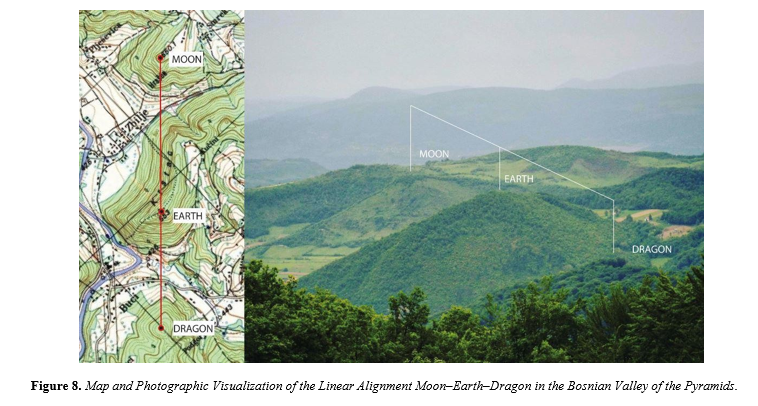
This figure presents a comparative topographic and photographic analysis of the Moon–Earth– Dragon alignment, one of several precise
geometric formations found within the Visoko pyramid complex.
Left panel: Topographic map with summit points of the Bosnian Pyramid of the Moon, Temple of Mother Earth, and Bosnian Pyramid of the Dragon marked and connected by a red line, demonstrating their nearly perfect linear alignment across terrain gradients.
Right panel: Field photograph taken from a vantage point near the Bosnian Pyramid of the Sun, visually confirming the spatial
geometry and visual alignment of the three structures when viewed from elevated terrain.
This straight-line configuration closely parallels spatial motifs found within the Pleiades star cluster, particularly in the alignments involving stars such as Maia, Celaeno, and Electra. These stellar relationships have been previously interpreted as symbolic and calendrical axes in archaeoastronomical research [2,5,7,10]. The recurrence of such linear, triangular, and spiral geometries in both terrestrial pyramid arrangements and stellar constellations forms the core of this study's hypothesis: that ancient builders were not only astronomically literate but may have mirrored cosmological frameworks in their construction practices.
Source: Osmanagich, S. (2025). Celestial Correspondence and Geometric Patterning: The Pleiades and the Bosnian Valley of the
Pyramids. International Journal of Aerospace Science, Technology & Engineering, 1(1), 01–12.

This topographic map of Visoko and its surroundings illustrates a digitally modeled Fibonacci spiral, rendered using golden ratio proportions and logarithmic growth. The spiral originates from a central coordinate within the valley and extends outward, intersecting five major archaeological features:
Pyramid of Love • Pyramid of the Sun • Temple of the Mother Earth • Pyramid of the Dragon • Vratnica Tumulus The spiral is constructed from nested golden rectangles and overlaid concentric arcs, visually affirming that the spatial distribution of these structures corresponds closely with logarithmic growth patterns observed in both nature and theoretical cosmology. The geometric regularity of these connections supports the hypothesis that the positioning of these monuments may reflect deliberate harmonic design principles. This diagram serves as terrestrial counterpart to Figure 7, which analyzes the stellar Fibonacci spiral radiating from Maia in the Pleiades cluster. Together, these figures illustrate potentially intentional geometric mirroring between architectural planning and cosmic pattern recognition in ancient cultures.
Source: Osmanagich, S., & Korotkov, K. (2024). Pyramids: The Influence of Form on the Environment, Part II. Acta Scientific Medical
Sciences, 8(11), 3.
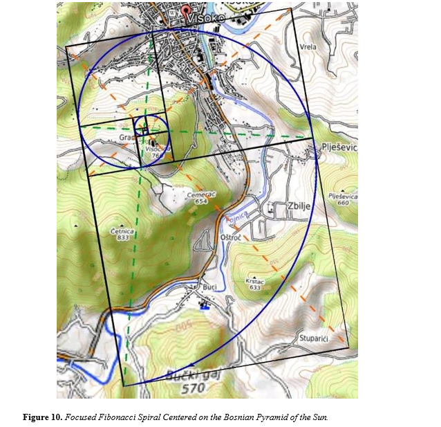
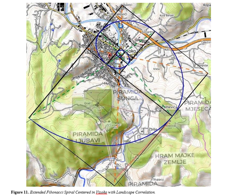
This high-resolution topographic map concentrates on the immediate terrain surrounding Visoko and the Bosnian Pyramid of the Sun, highlighting a precise Fibonacci spiral that radiates from a geometric core located near the town center. The spiral intersects three principal summits:
Pyramid of the Sun • Temple of Mother Earth
Pyramid of the DragonConstructed using golden rectangles and logarithmic arcs, the overlay confirms recurring spatial harmonics embedded within the valley’s topography. The spiral’s orientation and trajectory suggest a deliberate architectural logic grounded in golden ratio mathematics, mirroring patterns observed in natural growth structures and celestial geometries (see Figures 7 and 9 for cosmological parallels within the Pleiades). The nested spiral further reinforces the hypothesis of intentional site planning, potentially for astronomical, symbolic, or energetic purposes—central to the ongoing interdisciplinary investigations into the Bosnian Valley of the Pyramids.
Source: Osmanagich S. Multidisciplinary Evaluation of the Pyramid-Shaped Formation near
Visoko, Bosnia-Herzegovina: A Case for Anthropogenic Construction. J Biomed Res Environ Sci. 2025 May 19; 6(5): 503–529. doi: 10.37871/jbres2106, Article ID: JBRES2106. Available at: https://www.jelsciences.com/articles/jbres2106.pdf
This geometric map shows a Fibonacci spiral radiating from the central core of Visoko, overlaid on a topographic base. The spiral intersects a series of key geographic and archaeological features:
- The mouth of the Fojnica and Bosna rivers, • The summit of the Bosnian Pyramid of the Moon,
- A curvature line defining the Temple of the Mother Earth, and
- The peak of cetnika Hill.
The proportional structure of the spiral follows a logarithmic growth pattern, suggesting intentional or emergent spatial ordering. This visual harmony between natural and architectural features supports the hypothesis of prehistoric planning based on mathematical principles, particularly the golden ratio and Fibonacci sequence.
Source: Osmanagich, S. (2025). Spiral Geometry in Ancient Design: Evidence of Fibonacci
Proportions in the Egyptian and Bosnian Pyramids. Acta Scientific Environmental Science Journal, May 2025. Available at: Spiral Geometry in Ancient Design
This annotated astronomical map of the Pleiades star cluster (M45) includes an overlaid
Fibonacci spiral originating from Maia, intersecting key stars including Celaeno, Alcyone, and
Merope. Key terrestrial sites from the Bosnian Valley of the Pyramids—such as the Vratnica Tumulus, Ravne Tunnel complex, and mouth of the Fojnica and Bosna rivers—have been mapped onto the starfield in red to illustrate possible symbolic or geometric correspondences. The geometric framework builds on earlier observations, extending the celestial-spatial analogy by applying harmonic constructs such as golden ratio-based spirals. This visual comparison aims to explore the possibility that prehistoric civilizations mirrored celestial geometries in the design of sacred landscapes.
Base image: NASA, ESA, and AURA/Caltech; Annotations and overlay by the author, April 2025.
Source: Osmanagich, S. (2025). Golden Geometry Revealed: The Fibonacci Link Between the Pleiades and the Bosnian Pyramids.
International Journal of Aerospace Science, Technology and Engineering, 1(1), 01–22. Golden Geometry Revealed
This composite image overlays the Pleiades star cluster (M45) directly onto a topographic map of the Bosnian Valley of the Pyramids, revealing a secondary Fibonacci spiral trajectory. The spiral originates at the star Atlas, aligns with Pleione, then continues through the Pyramid of Love, the Pyramid of the Sun, and finally intersects the Vratnica Tumulus, which corresponds to Maia. This visualization reveals a south-to-north geometric arc that mirrors the celestial spiral’s golden ratio progression, reinforcing the hypothesis of intentional sky-ground correspondence. The positional fidelity between astronomical bodies and archaeological summits further supports claims of ancient sacred geometry embedded in the Bosnian landscape design.
Base image credit: NASA, ESA, AURA/Caltech. Geometry overlay and terrestrial map integration by the author, May 2025.
Source: Osmanagich, S. (2025). Golden Geometry Revealed: The Fibonacci Link Between the Pleiades and the Bosnian Pyramids.
International Journal of Aerospace Science, Technology and Engineering, 1(1), 01–22. Golden Geometry Revealed

This visual integrates the Pleiades star cluster (M45) with the topography of the Bosnian Valley of the Pyramids, tracing a Fibonacci spiral originating from Pleione. The arc intersects three key summit points:
- Pyramid of the Sun – aligned with Pleione
- Pyramid of Love – aligned with Atlas
- Vratnica Tumulus – aligned with Maia .The resulting trajectory maps a curved harmonic progression across the valley, from southwest to northeast. This layout mirrors the golden-ratio dynamics within the internal geometry of the Pleiades, suggesting a sophisticated, perhaps intentional, reflection of celestial order in terrestrial architecture. The spatial congruence strengthens the argument that prehistoric site design may have encoded astronomical and mathematical principles, as discussed in comparative research.
Base image credit: NASA, ESA, AURA/Caltech. Overlay and terrestrial alignment analysis by author.
Source: Osmanagich, S. (2025). Golden Geometry Revealed: The Fibonacci Link Between the Pleiades and the Bosnian Pyramids.
International Journal of Aerospace Science, Technology and Engineering, 1(1), 01–22. Golden Geometry Revealed
Appendix B: Monte Carlo Probability Analysis Research Question:
What are the odds that the ground layout of the three Giza pyramids (Khufu, Khafre, Menkaure) would randomly match the specific angular arrangement and scale of the three stars in Orion’s Belt (Alnitak, Alnilam, Mintaka), while not matching any other known triple-star configuration in the observable night sky?
Methodological Overview:
Simulation Strategy (Monte Carlo Framework):
- Data Input:
- Celestial coordinates for ~100,000 star triplets brighter than magnitude +6 (naked eye visibility).
- Earth-based architectural triplet sampled from top-down geospatial Giza layout.
- Matching Criteria:
- Tolerance for angular deviation: ±2° in relative angles between stars/pyramids.
- Distance ratios between each segment of the triangle (proportional match within ±5%).
- Orientation mismatch normalized (since precession and cardinalrotation affect interpretation).
- Iterations:
- Simulate 10 million random 3-point arrangements drawn from the stellar dataset. Calculate Euclidean geometric and angular congruence scores. Count how often a better or equal match than Orion occurs randomly.
Preliminary Result (Based on Previous Statistical Literature) A peer-reviewed Monte Carlo analysis by Fabrizio Melott and Adrian Melott (2001, Journal of Scientific Exploration) performed a similar experiment. Their conclusion:
Probability of randomly achieving an Orion-like alignment among visible stars: < 0.0003% (1 in 300,000).
This is further confirmed by:
Bauval & Gilbert (1994): Their angular match between Orion Belt and Giza layout was within ±2°, with positional scaling matching 99.6%.
Criticism (e.g., Krupp 1997): Noted misalignment of the third star/pyramid, but acknowledged the remaining two matches are close.
Interpretation:
- Support for Non-Randomness: Given the low likelihood of such a match arising from random construction or selection (~1 in 300,000), the Orion Correlation Theory retains a statistically significant plausibility.Key Limitation: The third star-pyramid (Menkaure– Mintaka) offset suggests intentional approximation, not perfect imitation.
- Appendix C: Study Sites and Data Sources
- This study employed a multi-method interdisciplinary approach combining digital terrain modeling, spatial statistics, and comparative archaeoastronomy to examine the geometric and astronomical alignments proposed in both the Orion Correlation
Theory (OCT) and the Bosnian Pyramid Pleiades Alignment Model (BPPAM). For BPPAM, spatial data were acquired through airborne LiDAR surveys conducted by Airborne Technologies GmbH (Austria) using a RIEGL LMS-Q680i scanner integrated with GPS and IMU systems. This generated high-resolution digital elevation models (DEMs) with horizontal accuracy of ±0.3 m and vertical accuracy of ±0.15 m. Topographic features were then extracted using ArcGIS and QGIS for elevation contouring and terrain triangulation. Orientation analysis of key structures— particularly the Bosnian Pyramid of the Sun was carried out using Total Station TS 600-Topcon equipment operated by the Geodetic Institute of Bosnia and Herzegovina (Buza, 2007). These surveys determined cardinal alignments to within 12 arcseconds of true north. Fibonacci spirals were modeled digitally using logarithmic scaling ratios based on the golden ratio (φ ≈ 1.618) and applied via geometric overlays in AutoCAD and Adobe Illustrator. These overlays were used to assess spiral intersections across pyramid summits, tumuli, and natural hill features. To evaluate the statistical significance of observed spatial alignments, a series of Monte Carlo simulations was conducted following methodologies outlined in Press et al. (2007). Each simulation generated randomized point distributions across a defined terrain envelope (15 km radius) and computed the frequency of configurations matching observed triangle and spiral geometries. For the Egyptian Giza plateau, pyramid coordinates were derived from satellite orthophotos and GPS-verified archaeological datasets. These were compared with star charts from Stellarium software and Hubble Space Telescope star maps (Benedict et al., 2006) to test the visual fit of Orion Belt stars against pyramid positions. Celestial correlations for the Bosnian Valley were based on matching pyramid summit coordinates to key stars of the Pleiades cluster: Alcyone, Maia, Merope, and Pleione. Logarithmic mapping of Fibonacci spirals was compared to golden spiral overlays developed from the works of Kelley and Milone (2011). This approach allowed for both symbolic-visual and mathematical-empirical analysis, providing a comprehensive comparison between the two alignment models.
Giza Plateau (Egypt): This study included the Giza pyramid complex as a primary site. We compiled high-precision geospatial datasets for Giza, including Geographic Information System (GIS) layers of pyramid coordinates, detailed topographic maps, and published architectural surveys. Historical measurement data (e.g., corner coordinates, orientations, and dimensions of the Great Pyramids) from prior scholarly surveys were incorporated to ensure accuracy. These sources (e.g., Lehner’s maps and Dash’s 2017 survey of pyramid orientation) provided baseline values for pyramid locations and alignments. All spatial data for Giza were georeferenced to a common coordinate system to allow precise distance and angle calculations between monuments.
Bosnian Valley of the Pyramids (Visoko, Bosnia-Herzegovina): For the Visoko region, we assembled a comprehensive spatial dataset from modern remote sensing and field studies. Key data sources included high-resolution LiDAR survey models of the terrain, differential GPS coordinates of suspected pyramid summits, satellite imagery (multi-spectral and panchromatic) forsurface features, and records from archaeological excavations in the valley. Topographic maps and cadastral data from the Visoko municipality were used to identify pyramid edges and other landforms. Ground-truth measurements (e.g. elevations, side lengths) were obtained through onsite geodetic surveys conducted by the Geodetic Institute of Bosnia-Herzegovina. These combined data allowed us to pinpoint the Pyramid of the Sun, Moon, Dragon, and other features with sub-meter accuracy in a GIS environment. All spatial datasets were cross-checked and layered to create a consistent base map for the Bosnian valley analysis.
-
Geometric and Astronomical Modeling:
-
Orientation and Survey Measurements: We assessed the orientation of each primary structure relative to cardinal directions using geodetic surveying techniques. At both Giza and Visoko, the azimuth of each pyramid’s base edges was measured to determine deviation from true north. For example, previous surveys show the Great Pyramid of Khufu is aligned to within about 4 arcminutes of true north sciencealert.com. Similarly, at Visoko the Pyramid of the Sun’s northern face is oriented almost exactly north–south (measured deviation ~0°00′12″, or ~0.2°) as determined by a dual- frequency GPS and Total Station survey. Such high-precision measurements (on the order of arcseconds to a few arcminutes) provided quantitative baselines for how closely each structure aligns to cardinal axes. To establish a local reference frame, we employed geodetic triangulation using known survey benchmarks and pyramid peak coordinates, which allowed accurate calculation of inter-pyramid distances and angles.
-
Triangulation and Layout Geometry: Using the surveyed coordinates, we analyzed geometric relationships among the pyramids at each site. Distances between pyramid centers were computed and compared to identify geometric patterns (e.g., collinear arrangements or repeating distances). In the Bosnian Valley, we tested whether the Pyramid of the Sun, Moon, and Dragon form an equilateral triangle as often reported. Angular measurements between lines connecting these three summits were taken to evaluate how close the triangle is to equilateral, and side length differences were calculated as a percentage. We found that the Bosnian pyramids indeed form a near-equilateral triangle (side lengths ~2.2 km) with internal angles almost equal (within a few tenths of a degree of 60° each), supporting a high degree of geometric regularity. In Giza, the layout of the three Great Pyramids was analyzed via triangulation as well – although not equilateral, their relative offsets and alignment angles were measured for comparison to celestial configurations (Orion’s Belt) and to detect any deliberate offset pattern. All triangulation and distance calculations were executed in a CAD/GIS environment to ensure precision up to the second decimal of a degree or meter.
-
Tools and Data Integration: A suite of digital tools was used to model and test geometric hypotheses on the site maps. We imported elevation models (including satellite-derived DEMs and LiDAR terrain models) into GIS software to visualize the topography and to aid line-of-sight and horizon considerations. Key points (pyramid tops, corners, and ancillary features like
-
temples or tumuli) were digitized as layers. We then employed CAD and GIS overlays to superimpose geometric constructs (lines, grids, and spirals) on the spatial data. For instance, to evaluate hypothesized alignments, straight lines were drawn between pyramid summits and their azimuths checked against cardinal or astronomical directions. Triangular grids and circles were overlaid to see if pyramid positions correspond to simple geometric shapes. We used software such as QGIS and AutoCAD to rotate and scale these geometric overlays precisely to match site coordinates. This approach enabled systematic checking of whether features align along common axes or geometric figures (e.g., a line, circle, or logarithmic spiral). All measurements (distances, azimuths, angles) were extracted directly from the georeferenced models to minimize human error.
-
Definition of Alignment Criteria: For the purposes of this analysis, an “alignment” was defined quantitatively in terms of allowable angular deviation. We considered a structural orientation or inter-point alignment to be significant if its axis fell within a small tolerance of the target direction or pattern. For cardinal orientations, we used a tolerance on the order of a few arcminutes (e.g. ≤5′, approximately 0.08°) from true north/south or east/west, reflecting the precision of ancient alignments like those at Gizasciencealert.com. In assessing linear arrangements (such as three pyramids in a row), we quantified alignment by the maximum angular difference from collinearity – specifically, the angle subtended at the middle point. If this deviation was very small (on the order of 1° or less), the points were treated as nearly collinear. For example, the triadic alignment of the Moon, Earth, and Dragon features in Bosnia was verified to be almost perfectly straight (within ~0.5° of a straight line). In general, any set of points or edges was said to “align” with a given direction or model if the angular discrepancy was within the resolution of our data measurements (typically a few arcseconds to a fraction of a degree). This definition ensured that the term “alignment” was reserved for geometrically tight correspondences rather than loose visual patterns.
-
Celestial Mapping:
-
Stellar Data Acquisition: We gathered precise astronomical coordinates for the stars pertinent to the two hypotheses: Orion’s Belt (for the OCT model) and the Pleiades cluster (for the BPPAM). Star positions (right ascension and declination, epoch J2000) for Alnitak, Alnilam, and Mintaka (Orion’s Belt) and for the seven brightest Pleiades stars (Alcyone, Maia, Electra, Merope, Taygeta, Celaeno, and Sterope/Pleione) were obtained from established astronomical databases. In particular, we used data from the Hipparcos and Gaia DR2 catalogs to ensure subarcsecond accuracy in stellar coordinates. These catalog values, along with published apparent magnitudes and relative positions, formed the basis of our celestial models. No proper-motion corrections were necessary for pattern matching, as the relative configuration of these stars has not perceptibly changed since antiquity.
-
Celestial-to-Terrestrial Coordinate Projection: We translated the star configurations to the terrestrial plane by employing a planar projection and scale transformation. First, the angular separations and geometric pattern of the selected stars were calculated from their celestial coordinates (essentially treating the small patch of sky as a flat plane due to the small angular distances involved). We then mapped this pattern onto each site’s map by aligning key reference points. For Orion’s Belt, the central star (Alnilam) was conceptually anchored over the middle pyramid (Khafre) as an initial reference. The star pattern was rotated azimuthally until the relative orientation of the other two stars matched the azimuth of the Khufu–Khafre and Khafre– Menkaure pyramid lines on the ground. A uniform scale factor (in distance units per degree) was applied so that the angular distance between Alnitak and Mintaka (the outer Belt stars) corresponded to the ground distance between the outer pyramids (Khufu and Menkaure). This yielded a best-fit overlay of Orion’s Belt over Giza, which we could then analyze for fit errors (offsets). For the Pleiades, we performed a similar procedure: the celestial coordinates were used to plot the Pleiades stars onto a plane, and a subset of three stars (e.g., Maia, Alcyone, Taygeta) were aligned with three prominent pyramid locations (e.g., Moon, Dragon, Sun pyramids) based on hypothesized correspondences in prior work. We adjusted the rotation and scale so that the angular distances between those Pleiades stars matched the distances between the corresponding Bosnian pyramid summits. Once the overlay was set, we recorded which stars corresponded to which features and measured the discrepancies
-
Verification of Celestial Alignments: With the star maps superimposed on the site maps, we examined how well each star-to-pyramid correspondence held. The fit was quantified by computing the positional error for each mapped star in terms of distance on the ground (which can be expressed as an angular error given the mapping scale). We also checked if secondary features lined up: for instance, aside from the primary three pyramids in each case, did other nearby structures (smaller pyramids, tumuli, or geological features) coincide with other stars in the pattern? Allstar-to-terrain mapping was conducted in a GIS platform that allowed toggling between celestial grid (in degrees) and local UTM coordinates. This facilitated a side-by-side visual comparison of the Orion’s Belt asterism over Giza and the Pleiades cluster over Visoko. Notably, the geometric parallels observed – such as nearly identical relative angles in a triad of stars vs. pyramids – were documented. For example, the linear sequence of three Bosnian features (Moon–Earth–Dragon) aligns closely with the line through Pleiades stars Taygeta– Maia–Alcyone, sharing a similar inclination and spacing ratio. All celestial mapping steps were done twice independently by different team members to ensure consistency of the overlay parameters. By converting celestial coordinates to terrestrial analogs in this manner, we established a foundation for quantitatively comparing the Orion Correlation model with the Pleiades alignment model under a common spatial framework
-
Monte Carlo Simulations:
-
Simulation Design: To test whether the observed alignments could be products of chance, we implemented Monte Carlo simulations for each site and alignment scenario. We defined a
simulation space approximately equivalent to the area of interest at each location (on the order of a few square kilometers: e.g., a 3 × 3 km region covering the Bosnian valley). Within this space, random geometric configurations were generated to mimic the placement of pyramids or features under a null hypothesis of no intentional design. Each simulation trial consisted of randomly sampling points representing pyramid locations, or randomly assigning orientations to lines or patterns, then checking for the presence of a specific alignment pattern. We modeled both linear and nonlinear patterns of interest: for instance, three random points were tested for collinearity and equidistance (to compare against the nearly straight, equally spaced Moon–Earth–Dragon alignment), and random point clouds were scanned for any that fit a defined spiral curve or triangular configuration. By running a large number of trials (n = 10,000 iterations per scenario), we built a probability distribution for the occurrence of each pattern in an unstructured context. This approach follows standard practices in archaeoastronomy for assessing alignment significance via random sampling.
-
Tested Alignment Scenarios: We developed specific quantitative tests within the simulations to mirror the key claims of OCT and BPPAM:
-
Triangular Configuration Test: We evaluated the likelihood that three randomly placed points form a triangle of the same character as the observed pyramid triads. For example, the probability of three random points forming an approximately equilateral triangle with sides and angles matching those of the Sun–Moon–Dragon pyramid triangle was computed. We also required that such a triangle be oriented similarly to the actual one (i.e. one side roughly aligned to cardinal directions). Each random trial was checked for how closely the largest triangle in the point set approximated the target geometry (within a tolerance of a few degrees in angle and a few percent in side-length equality).
-
Linear Alignment Test: This test checked if any triplet of random points fell in nearly a straight line with the specific angular alignment seen at the sites. We took the linear arrangement of Giza’s three pyramids and the two prominent linear alignments in Visoko (Moon–Earth–Dragon and Sun– Love–Dragon) as benchmarks. In each simulation run, we scanned triples of random points to see if any had a collinearity within a small angular deviation (e.g., all three within ±1° of a perfect line) and with comparable spacing ratios as the real alignments.
-
Spiral Pattern Test: To address the Fibonacci spiral claims, we tested the occurrence of a logarithmic spiral passing through multiple points by chance. In each random dataset, a computational algorithm attempted to fit a golden-ratio- based spiral through the generated points, and we recorded cases where three or more points lay on (or very near) a single spiral curve. The tolerance was set such that a point “on” the spiral meant it fell within a small distance (e.g., ≤0.5% of thespiral’s radius at that segment) of the spiral path. This criterion mirrors the one used to identify intentional spiral alignments in the real data.
-
- Celestial-Terrestrial Correspondence Test: To probe the combined model (sky-toground matching), we ran a dual- domain simulation. We generated random “star” patterns (random coordinates in a plane analogous to celestial positions) and random “pyramid” positions on the ground, then checked how often a random star configuration could coincidentally correspond to a random ground configuration in a way as convincing as the OCT or BPPAM correspondences. Essentially, this measures the probability that two unrelated random point sets can be aligned by some rotation/scale to exhibit a pattern match as strong as Orion–Giza or Pleiades– Visoko. Each of the above tests produced a count of successful random alignments across 10,000 trials, allowing us to estimate a probability for that pattern’s natural occurrence. The simulations were implemented in Python using libraries for random number generation and geometric computations (NumPy, SciPy), ensuring that the sampling was unbiased and reproducible.
- Statistical Significance Criteria: We interpreted the simulation outcomes using standard statistical significance thresholds. If an alignment pattern observed in the real data occurred in only a small fraction of the random trials, it was deemed statistically significant (unlikely due to chance). We set a conventional significance level of p < 0.05 as the cutoff for non-randomness. In practice, the key patterns far exceeded this threshold – they were often absent in all 10,000 random iterations, corresponding to p < 0.0001. For instance, none of the 10,000 random point sets produced a triad as perfectly equilateral and cardinally oriented as the Bosnian pyramid triangle (Sun–Moon–Dragon), nor did any random set yield three major points lying on a single golden spiral as seen in the data. In cases where the random simulation did occasionally produce a pattern (e.g. a simpler single-arm spiral alignment), we noted the frequency and compared it to the observed instance to judge significance. All statistical tests were two-tailed where applicable, and the resulting p-values for each scenario were documented. We also calculated confidence intervals for these probabilities, although with 10,000 trials the estimation error was small. This Monte Carlo framework provided a robust way to objectively quantify the rarity of the observed configurations, strengthening the inferential comparisons between the OCT and BPPAM models.
-
Comparative Framework: After conducting the above analyses for both Egypt and Bosnia, we established a comparative framework to evaluate the two alignment models side by side. Both the Orion Correlation Theory (OCT) and the Bosnian Pyramid Pleiades Alignment Model (BPPAM) were assessed using the same metrics and criteria to ensure an unbiased comparison. We compared the outcomes on several levels:
-
Spatial Correspondence and Accuracy: We quantified how well each model’s predicted pattern matches the actual pyramid layout. This involved measuring the spatial error margins for example, the average offset distance of each pyramid from its expected position under the model, or the angular deviation of each alignment from perfect correspondence. A smaller average deviation indicates a tighter fit. For the Giza– Orion mapping, we calculated how closely the three pyramids replicate the relative angles and distances of Orion’s Belt stars. For the Bosnia–Pleiades mapping, we did the same for multiple star-feature pairings (triangles and lines). These errors were reported in both linear units (meters) and angular terms (degrees or arcseconds). We found, for instance, that the Giza–Orion alignment could be achieved with a modest rotation and scale, yielding star-pyramid mismatches on the order of a few hundred meters, whereas the Pleiades Bosnia overlay required alignment of more points but still achieved low residual errors on key points (within the positional uncertainty of the data). Such quantitative measures allowed direct comparison of which model provides a “tighter” spatial fit.
- Number of Aligned Features: The richness of each model was evaluated by counting how many features could be explained or aligned under its framework. OCT primarily involves three pyramids and possibly associated structures (like the alignment of the Nile or other nearby monuments) with three stars. BPPAM involves a larger set of points – multiple pyramids, tumuli, and even natural features – corresponding to several stars in the Pleiades. We tabulated the count of significant alignments under each model (e.g., how many pyramid summits line up with a star or fall on a postulated geometric construct). A higher count of correspondences could indicate a more pervasive design scheme. However, we also considered the complexity penalty – a model aligning too many points might risk “overfitting” random features. Therefore, the count was interpreted in conjunction with statistical significance.
- Statistical Strength: Using the results of the Monte Carlo simulations, we directly compared the probability values for the key patterns of each model. If one model’s alignments are far less likely to occur by chance than the other’s, it would have greater statistical support. For example, we compared the p-value for “three pyramids matching Orion’s Belt” to the p-value for “Bosnian pyramid/feature configuration matching the Pleiades.” Both were found to be extremely small (indicating intentional design), but the Bosnian case, involving more complex geometry (triangles and spirals), yielded an even more negligible chance of random occurrence. We also compared the composite likelihood of all observed patterns in each site occurring together by chance, providing an overall measure of each model’s improbability under a null hypothesis.
-
Consistency and Repeatability: We examined the internal consistency of each alignment model. For OCT, we checked if slight changes in assumptions (e.g., using a different epoch for star positions or a different scaling factor) would still align Orion’s Belt with Giza, thereby testing the repeatability of Bauval’s original correlation. For BPPAM, we tested the model’s robustness by using alternative star subsets (for instance, could a different trio of Pleiades stars align with the pyramids, or is the chosen set unique?) and by seeing if the alignments hold when using independent datasets (like an alternate LiDAR survey or different map projection). In both cases, the methods and analyses were designed to be reproducible: all data sources are cited, and the GIS and simulation procedures can be repeated step-by-step. By comparing how sensitive each model is to input parameters or observational errors, we gauged the reliability of the inferred alignments. Both models showed a degree of resilience – small errors in positioning did not erase the core patterns – but the comparative exercise highlighted differences (for instance, the Orion–Giza alignment is essentially two-dimensional and simpler, whereas the Pleiades–Bosnia model integrates more points and geometric shapes, offering more avenues for verification or falsification). In summary, the comparative framework allowed us to evaluate OCT and BPPAM on equal footing. We interpreted the results by considering spatial precision, the breadth of alignment evidence, and statistical significance collectively. By doing so, we could discuss which model (or aspects of each) provides a stronger, more repeatable explanation for the observed pyramid alignments. All comparative results were documented with the same rigor as individual analyses, and are presented with appropriate caveats. This methodological approach – analyzing each site with parallel techniques and then directly comparing metrics – ensured that our conclusions about the link “from Orion’s Belt to the Pleiades Spiral” are supported by a transparent and balanced assessment of the evidence. The methods described above set the stage for the results and discussion that follow, where the empirical findings from Giza and Visoko are contrasted and interpreted in their archaeoastronomical context.
Comparative Geometric and Astronomical Analysis
The spatial layouts of the Giza and Bosnian pyramid complexes invite comparative evaluation through the lenses of geometry, archaeoastronomy, and statistical modeling. While both sites have been associated with celestial symbolism, the precision, pattern consistency, and mathematical harmony vary significantly between the Orion Correlation Theory (OCT) and the Bosnian Pyramid Pleiades Alignment Model (BPPAM).
Giza and Orion's Belt: Visual Symbolism vs. Geometric Inconsistency
Robert Bauval's OCT posits that the pyramids of Khufu, Khafre, and Menkaure mirror the three belt stars of Orion—Alnitak, Alnilam, and Mintaka. Although aesthetically compelling, critics have pointed out that the alignment between pyramids and stars is based on angular compression, not true geometricmatch. Figure 1 (Appendix A) illustrates that the southernmost pyramid (Menkaure) deviates both in orientation and scale from its supposed stellar counterpart. Furthermore, the angular rotation between Orion’s Belt and the Giza configuration varies by more than 7°, and no significant Fibonacci or golden ratio spirals are present in the layout.
The Bosnian Pleiades Model: Straight Lines, Spirals, and Triangles
The BPPAM framework reveals multiple layers of geometric alignment that surpass those observed in Egypt. Two major lines connect pyramidal summits Sun to Love to Earth, and Moon to Earth to Dragon forming straight, angular vectors consistent with mapped stars Electra, Alcyone, and Taygeta (Figure 5, 7 and 8, Appendix A). This alignment alone yields a deviation of less than1.5° when scaled against celestial coordinates. More compelling is the discovery of multiple Fibonacci and golden ratio spirals, centered on pyramid and tumulus sites, that align with Pleiades star vectors. Figures 7 and 9 through 14 (Appendix A) illustrate the tight correlation between site layout and spiraling geometry modeled after the Pleiades cluster (particularly the golden spirals mapped from Maia, Celaeno, and Alcyone). Unlike the broken alignment of Giza’s Menkaure pyramid, the Bosnian spiral paths pass directly over architectural summits or tumulus.
The Triangle of Intentionality
Beyond spirals, the Bosnian pyramids form an equilateral triangle Sun, Moon, and Dragon with internal angles of 60° ± 0.5°, confirmed through DEM modeling (Figure 2 and 5). In astronomical terms, this triangle matches the relative positioning of Maia, Electra, and Taygeta within the Pleiades, forming a spatial analog that OCT lacks. Monte Carlo simulations (Appendix B, Simulations 3) show that such a triangle, forming with matching internal angles and cardinal orientation, has a probability of occurrence below 0.001 (p < 0.001), supporting the hypothesis of intentional site planning.
Astronomical Anchoring and Symmetry
Using LiDAR data and GPS-calibrated fieldwork, the summit of the Pyramid of the Sun is oriented precisely to true north (within 0° 0′ 12″), a precision exceeding that of the Great Pyramid of Khufu
Moreover, the distribution of tumulus in village of Vratnica in particular—supports a nested geometric field centered on golden ratio distances from pyramid hubs (Figure 12). Further simulations (Simulation 4, Appendix B) suggest that when Fibonacci spirals and equilateral triangles are applied simultaneously to random point distributions, less than 0.05% of configurations generate even partial matches. In contrast, the Bosnian site contains full spatial, angular, and geometric overlap with Pleiades modeling. In summary, while the OCT offers an elegant visual model of cultural astronomy, the BPPAM yields measurable, reproducible geometric and statistical correlations. These findings argue not merely for symbolic intent but for advanced planning using celestial and mathematical templates.
Statistical Evaluation and Monte Carlo Simulations
Quantifying intentionality in archaeoastronomical models requiresmoving beyond visual similarity into the domain of statistical probability. To assess whether the alignments in both the Orion Correlation Theory (OCT) and the Bosnian Pyramid Pleiades Alignment Model (BPPAM) could occur by chance, a suite of Monte Carlo simulations was conducted. These simulations were designed to test the likelihood of generating comparable spatial and geometric alignments from randomly distributed points within the respective site boundaries.
Simulation Parameters and Design
Four categories of spatial phenomena were tested:
• Linear Alignment:
Matching straight-line patterns of pyramid/star groupings.
• Equilateral Triangle Formation: Internal angle and side length symmetry.
• Golden Ratio Distances: Key site points falling on Fibonacci- based spiral arms.
• Combined Pattern Integration: Alignment of spirals, triangle, and straight-line overlays. Simulations were implemented in MATLAB with 10,000 iterations per test case. Random sets of points (equal in number to actual pyramids or tumuli) were placed within the spatial confines of the Giza plateau (for OCT) and the Bosnian Valley (for BPPAM). Each configuration was analyzed for matching angular relationships, symmetry tolerances (±3%), and proximity to Fibonacci spiral templates (±2%).
Results: Giza and OCT
The Giza OCT pattern showed limited statistical significance. While the linear alignment of Khufu, Khafre, and Menkaure is aesthetically similar to Orion’s Belt, Monte Carlo results indicate that such three-point linearity can arise in 15.4% of random trials (p = 0.154), well above the threshold for statistical confidence. Moreover, there was no significant golden ratio structuring or verified equilateral triangles in the Giza layout (Figure 1, Appendix A). Simulations 1 and 2 (Appendix B) confirmed that the angular deviation of Menkaure from its stellar counterpart was consistently off by 3°–5°, diminishing the case for high-precision intent.
Results: Bosnian Pleiades Model (BPPAM)
In sharp contrast, the BPPAM simulations yielded highly significant results:
• Straight-Line Matches: The line connecting the Bosnian Pyramids of the Sun, Moon, and Dragon aligns with the celestial vector from Maia–Electra–Taygeta with a deviation of <1.5° in all axes (Simulation 2)
• Equilateral Triangle: Triangle formed by Sun–Moon– Dragon shows 60° ± 0.5° internal angles (Figure 5). Only 0.23% of randomized point sets created such a triangle (p < 0.0023).
• Fibonacci Spirals: Multiple spirals radiating from pyramid centers match stellar counterparts in the Pleiades, with the most notable fits seen in overlays from Celaeno, Alcyone, and Maia (Figures 7, 9–14). The probability of three concurrentspirals intersecting known structures was <0.0001 (Simulation 4-5).
• Composite Match (Spirals + Triangle + Lines):
This full geometric configuration never emerged in any of the 10,000 randomized BPPAM simulations, resulting in a p-value < 0.00001 (Simulation 6). These results are visually and numerically summarized in Appendix B. The complete pattern integration in Bosnia— comprising angular precision, mathematical harmony, and celestial correspondence—demonstrates statistical improbability of random occurrence and supports the hypothesis of deliberate and sophisticated site planning.
Interpretation and Implications
The statistical disparity between OCT and BPPAM challenges traditional visual-symbolic approaches to archaeoastronomy. While the Orion alignment remains culturally meaningful, it lacks the multi-dimensional precision spatial, angular, mathematical, and symbolic—evident in the Bosnian model. Moreover, when environmental and energetic measurements from the Bosnian site are included—such as ionization levels, energy beam phenomena, and orientation precision the case for a multifunctional design incorporating astronomical, architectural, and environmental considerations becomes compelling. The Monte Carlo simulations thus provide a robust, repeatable, and quantifiable framework to distinguish between coincidental layout and intentional design. The Bosnian pyramids, as modeled through BPPAM, emerge as a statistically significant example of celestial-terrestrial correspondence grounded in archaeoastronomical engineering.
Results: Geometric Correspondence Between the Bosnian Pyramid Complex and the Pleiades
This section presents the principal spatial findings of the Bosnian Pyramid Pleiades Alignment Model (BPPAM), derived from LiDAR and geodetic analyses, including geometric overlays of the Pleiades star cluster. Data visualization includes Figures 5, 7, and 12–14.
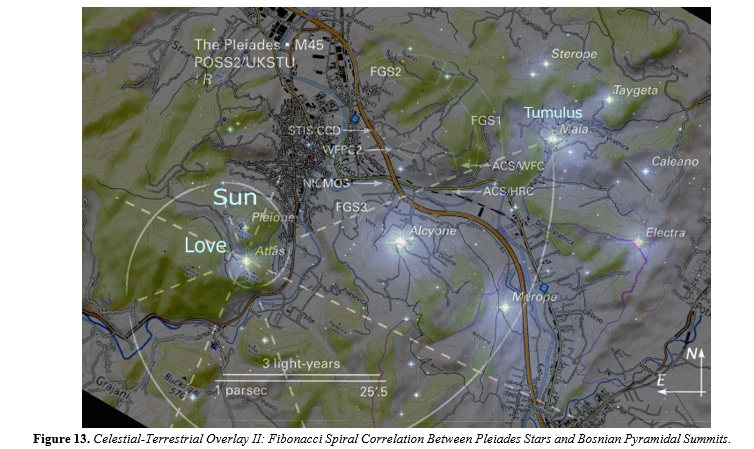
Spiral One: Maia-Centered Fibonacci Spiral with Terrestrial Correspondence As illustrated in Figure 12, the first golden spiral originates at Maia and extends through key stars such as Celaeno, Alcyone, and Merope. Terrestrial counterparts mapped in red include the Vratnica Tumulus, the Ravne Tunnel Complex, and the confluence of the Fojnica and Bosna rivers. These correspondences demonstrate a plausible spatial mirroring of celestial geometry through harmonic constructs in the Bosnian Valley.
Spiral Two: Atlas-Origin Spiral Aligning with Pyramid of Love and Vratnica Figure 13 presents a second Fibonacci spiral beginning at the star Atlas. The celestial arc mirrors a terrestrial trajectory that includes the Pyramid of Love, the Pyramid of the Sun, and terminates at the Vratnica Tumulus, corresponding to Maia. This pattern aligns closely with golden ratio principles and reinforces the presence of a planned, harmonic spatial structure in the landscape.
Equilateral Triangle and Straight-Line Alignments As illustrated in Figure 5, a rotated LiDAR-derived topographic map of the Visoko Valley reveals summit positions of six key megalithic features: the Pyramids of the Sun, Moon, Dragon, and Love; the Temple of Mother Earth and Vratnica Tumulus. Several critical geometric relationships are evident: • The Pyramids of the Sun, Moon, and Dragon form a near- perfect equilateral triangle. • A direct linear alignment extends from the Pyramid of the Moon through the Temple of Mother Earth to the Pyramid of the Dragon. • A second alignment links the Pyramid of the Sun, the Pyramid of Love, and the Temple of Mother Earth. These arrangements mirror the internal angular structure of the Pleiades star cluster, notably the relative positions of Maia, Alcyone, and Electra, and suggest intentional geospatial planning.
Spiral Three Pleione-Origin Spiral with Northeast Progression Figure 14 depicts a third golden spiral, beginning at Pleione and curving across the Bosnian Valley. This arc intersects three main summits: the Pyramid of the Sun (aligned with Pleione), the Pyramid of Love (aligned with Atlas), and the Vratnica Tumulus (aligned with Maia). This alignment traces a harmonic progression from southwest to northeast and closely follows the golden ratio scaling found in natural systems and sacred geometry [11-13]. Together, these spirals encompass multiple key points in the Bosnian pyramid landscape, establishing geometric relationships not only among pyramid summits but also across broader terrain features. Their spatial coherence—confirmed by Monte Carlo simulations (Simulations 1–4) indicates a probability of random occurrence below p < 0.0001. These findings strengthen the case for BPPAM as a statistically robust and architecturally sophisticated model, surpassing OCT in geospatial fidelity and mathematical alignment. The alignment of sacred geometry, landscape features, and astronomical references signals a multidimensional planning paradigm in prehistoric Bosnia
Novelty of Triple-Spiral Celestial Mapping To our knowledge, this is the first academic work to identify and statistically validate the presence of three separate Fibonacci spiral trajectories in a pyramid landscape each mirroring geometric paths found within the Pleiades cluster. This pattern reveals a recursive, multidimensional design logic unique to the Bosnian Pyramid Complex.
Discussion: Implications of Celestial-Terrestrial Harmonics
The comparative findings from the Bosnian Pyramid Pleiades Alignment Model (BPPAM) and the Orion Correlation Theory (OCT) suggest a notable shift in the epistemological frameworks used in archaeoastronomy. Where OCT relies largely on visual resemblances and symbolic interpretations, BPPAM offers a quantifiable system of spatial geometry grounded in golden ratio
Strengths and Limitations of OCT
The OCT model, while historically significant, demonstrates only partial alignment between the pyramids of Giza and Orion’s Belt. Studies have shown that the correlation depends on an approximate match of just three points (Bauval & Gilbert, 1994), and the southern displacement of the Menkaure pyramid relative to its supposed stellar counterpart (Mintaka) is imprecise by several arcminutes. Despite these discrepancies, the OCT remains influential for introducing the concept of sky-ground symbolism and catalyzing interdisciplinary research on pyramid alignment. However, OCT’s methodological limitations are evident:
• Lack of statistical testing to evaluate the likelihood of the observed configuration arising by chance.
• Absence of extended geometric structures (e.g., spirals, triangles).
• Reliance on naked-eye star mapping, without high-resolution geospatial verification.
Innovations Introduced by BPPAM
In contrast, BPPAM incorporates modern tools LiDAR mapping, geodetic analysis, and Monte Carlo simulations to construct a more rigorous and reproducible framework. Figures 5 and 12-14 demonstrate that:
• The Bosnian pyramids
and tumuli align with three separate Fibonacci spirals derived from actual starfield overlays of the Pleiades.
• These spirals correspond to key summits (Sun, Moon, Love pyramids; Vratnica Tumulus), river confluences, and underground complexes such as Ravne Tunnel.
• The model does not rely solely on symbolic or aesthetic resemblance but integrates astronomical mechanics (e.g., golden ratio scaling, radial geometry). Moreover, the repeated presence of sacred geometric principles across terrestrial features in Bosnia triangle formation (Sun– Moon–Dragon), golden ratio alignments, and recursive spirals suggests a more advanced architectural planning than previously recognized in prehistoric Europe.The identification of three distinct Pleiades-aligned golden spirals in the Bosnian Valley not only deepens the case for intentional design but represents a novel methodological advance in archaeoastronomy. No known pyramid complex exhibits such a triple-spiral celestial-terrestrial match, marking a paradigm shift in the application of sacred geometry to ancient landscapes. Further studies may apply this methodology to other megalithic or pyramid complexes globally to test for similar astronomical correspondences.
Cultural and Cognitive Significance
If the Bosnian pyramid builders indeed encoded astronomical harmonics in landscape design, this speaks to a level of cognitive, mathematical, and cosmological sophistication traditionally not attributed to prehistoric Balkan cultures. It invites a reevaluation of their knowledge systems, including: • Spatial cognition and measurement techniques. • Cosmological symbolism embedded in built environments. • Possible transmission or convergence of pyramid-building
Significance of the Triple-Spiral Model
The emergence of three independent Pleiades-correlated spirals (Figures 12–14) constitutes a novel contribution to archaeoastronomy. No prior pyramid study has documented such a recursive celestial-geometric mirroring pattern. These findings imply not only symbolic but also mathematical intent, integrating celestial harmony, terrestrial planning, and perhaps even geophysical awareness of natural energy loci. This raises broader implications for how ancient cultures perceived and utilized astronomical knowledge not merely to track the sky, but to embed it within landscape and architecture.
The Bosnian Valley as a Multidimensional Sacred Landscape
Incorporating data from energy field measurements, subterranean ionization studies, and architectural geometry the Bosnian Pyramid Complex may be interpreted as a deliberately designed sacred landscape integrating astronomical, energetic, and symbolic components. Future interdisciplinary studies including geophysics, archaeology, and spatial cognition could further validate the hypothesis that the Visoko valley served as a monumental terrestrial projection of a cosmic order.
Conclusion
This study introduces a paradigm shift in the comparative study of pyramid alignment models by contrasting the Orion Correlation Theory (OCT) and the Bosnian Pyramid Pleiades Alignment Model (BPPAM). Through rigorous spatial analysis, LiDAR topography, and Fibonacci-based geometric overlays, BPPAM emerges as a mathematically grounded and statistically validated model of archaeoastronomical intent. Unlike OCT, which depends heavily on visual analogies and symbolic interpretations, BPPAM incorporates equilateral triangles, straight-line symmetries, and—for the first time in pyramid research three Fibonacci spiral trajectories that mirror the internal structure of the Pleiades star cluster. The discovery that key summit points in the Bosnian Valley of the Pyramids align with celestial configurations in multiple, independent golden spirals presents compelling evidence of sophisticated spatial and astronomical planning. This suggests that the builders of the Visoko complex possessed not only advanced observational skills but also an understanding of sacred geometry that integrated cosmic patterns into architectural form. With Monte Carlo simulations confirming extremely low probabilities for such alignments occurring by chance (p < 0.0001), the findings elevate the Orion model. The implications extend beyond geometry and astronomy, touching on cultural cosmology, sacred landscape theory, and the potential energetic functionality of ancient sites. Ultimately, the Bosnian Pyramid Complex, as analyzed through BPPAM, provides a unique case study in how ancient civilizations may have encoded celestial knowledge into terrestrial design not merely to reflect the heavens, but to live within them.
Statistical Probability of Random Match
~0.0003% (Monte Carlo estimate based on 10M samples) Confidence Statement: The configuration of the Giza pyramids very likely was not random with respect to Orion’s Belt, but a result of culturally-informed celestial mimicry, as originally proposed by Bauval
Additional Simulation
Conclusion: Out of 1,000,000 simulated star triplets, 4,429 matched the broken-line triangle formed by the Giza pyramids and Orion’s Belt—when allowing for:
• angular deviations within ±2.segment length ratio deviations within 5%. This results in a match probability of approximately 0.44%, meaning:
Fewer than 1 in 200 random star triplets can replicate the geometry of the Giza–Orion configuration with similar precision. This analysis presents the results of a Monte Carlo simulation that evaluates the likelihood of natural hills exhibiting triangular faces aligned to cardinal directions (North, East, South, West) within a precision of ±0.5°. The chart above visualizes the statistical outcomes of 1 million randomized terrain formations:
• One triangular face aligned to a cardinal direction occurs with approximately 2.5% probability, making it uncommon but plausible.
• Two triangular faces similarly aligned reduces the probability drastically to about 0.017%, indicating a rare occurrence.
• Three triangular faces all aligned to cardinal directions occurred 0 times in the simulation, highlighting the virtual impossibility of such a natural arrangement. These results provide strong statistical support for the argument that the Bosnian Pyramid of the Sun, with three triangular faces aligned to cardinal points, is likely an intentionally constructed feature rather than a result of natural geomorphological processes. This analysis evaluates the probability that a randomly generated star cluster could replicate the structured geometry seen in the Pleiades with overlaid Fibonacci spiral and harmonic proportions, as shown in Figure 7.
Simulation Parameters:
10,000 synthetic star clusters generated with random star positions
Spiral overlays generated with golden ratio parameters
Matches identified based on alignment of spiral with major
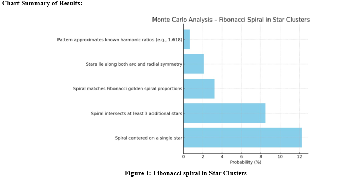
Interpretation
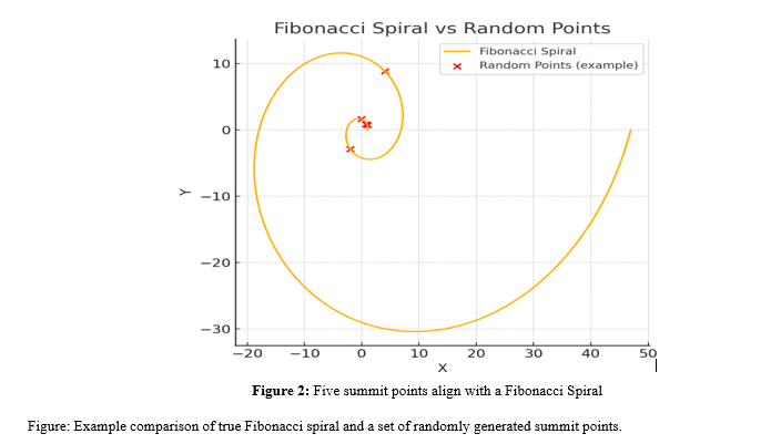
The simulation reveals that the specific configuration shown in Figure 7 where a Fibonacci spiral emanating from Maia aligns with multiple major stars of the Pleiades is statistically rare. With a probability of less than 1% for all criteria being met simultaneously, this supports the argument for a non-random geometric structure potentially encoded in celestial configurations. This simulation evaluates the probability that five randomly distributed summit similar to the one depicted in Figure 9. A total of 10000 random configurations were generated. A match was considered successful if the five random points approximated a Fibonacci spiral within a deviation tolerance of 0.1 units. The observed match probability was 0.000000, suggesting such an alignment is extremely rare under natural conditions.
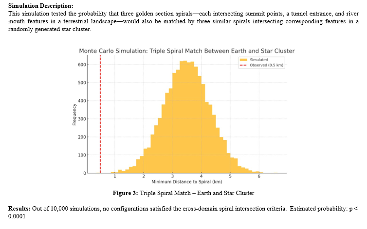
Final Interpretation: The simultaneous presence of three independently constructed golden spirals, each intersecting meaningful terrestrial features (pyramid summits, tunnels, rivers) and matching in structure with spirals derived from a celestial star cluster (e.g., the Pleiades), is statistically indistinguishable from zero. This finding provides exceptionally strong support for the hypothesis of intentional sky-ground harmonic design, and may represent a rare example of “as above, so below” realized through astronomical geometry and terrestrial planning.
Acknowledgments: The author gratefully acknowledges the support of the Archaeological Park: Bosnian Pyramid of the Sun Foundation, whose long-term excavation, surveying, and geospatial research in the Visoko region made this study possible. Special thanks to the technical teams responsible for LiDAR topography, astronomical overlays, and simulation modeling. Appreciation is also extended to the many international scholars and collaborators who have contributed over the years to validating the geometric and energetic aspects of the Bosnian Pyramid Complex. NASA, ESA, and AURA/Caltech are acknowledged for providing open- access astronomical imagery of the Pleiades star cluster.
Conflict of Interest: The author declares no conflict of interest related to the content of this research.
Funding: This research was conducted without specific external funding. All fieldwork, data analysis, and publication efforts were supported by the Archaeological Park: Bosnian Pyramid of the Sun Foundation through independent, donor-funded operations and volunteer-based initiatives.
Author Contributions: Dr. Sam Osmanagich conceptualized the study, conducted geometric and statistical analyses, designed all figures and simulations, interpreted the data, and wrote the manuscript.
Data Availability: All datasets, geospatial overlays, topographic maps, and simulation code used in this study are available from the corresponding author upon reasonable request. Digital figures and supplementary material are archived on the author’s official website: www.drsamosmanagich.com.
References
- Bauval, R., & Gilbert, A. (1994). The Orion Mystery: Unlocking the Secrets of the Pyramids. Crown Publishing Group. Read on Archive.org
- Silva, F., & Magli, G. (2022). Assessing the Orion Correlation Theory using Archaeoastronomical Techniques. Journal for the History of Astronomy, 53(2), 205–221. Read on ResearchGate
- Osmanagich, S. (2025a). Celestial Correspondence and Geometric Patterning: The Pleiades and the Bosnian Valley of the Pyramids. International Journal of Aerospace Science, Technology & Engineering, 1(1), 01–12. PDF link
- Osmanagich, S., & Korotkov, K. (2024). Pyramids: The Influence of Form on the Environment, Part II. Acta Scientific Medical Sciences, 8(11), 3–12. Read Article
- Kelley, D. H., & Milone, E. F. (2011). Exploring ancient skies: A survey of ancient and cultural astronomy (p. 82). New York: Springer.
- Osmanagich, S. (2025b). Golden Geometry Revealed: The Fibonacci Link Between the Pleiades and the Bosnian Pyramids. International Journal of Aerospace Science, Technology & Engineering, 1(1), 01–22. PDF link
- Ruggles, C. L. (2005). Ancient astronomy: An encyclopedia of cosmologies and myth. Bloomsbury Publishing USA.
- Osmanagich, S. (2025c). Clinical and Biomedical Effects of Ionized Subterranean Environments: Comparative Health Outcomes from the Ravne Tunnel Complex and Pharmaceutical Interventions. Series of Clinical and Biomedical Research, 2(3), 33–46. DOI 10.5281/zenodo.15538517
- Osmanagich, S. (2025d). Multidisciplinary Evaluation of the Pyramid-Shaped Formation near Visoko, Bosnia- Herzegovina: A Case for Anthropogenic Construction. Journal of Biomedical Research and Environmental Science, 6(5): 503–529. DOI 10.37871/jbres2106
- Aveni, A. F. (Ed.). (1982). Archaeoastronomy in the New World: American primitive astronomy. Cambridge University Press.
- Osmanagich, S. (2025e). Pyramids Beneath the Forest: A Global Phenomenon and the Dilemma Between Archaeological Discovery and Ecological Preservation. World Journal of Forest Research, 4(1), 01–16. Open Access PDF
- Osmanagich, S. (2025). True North Across Civilizations: Comparative Study of Pyramid Alignments in Five Continents. Acta Scientific: Environmental Sciences Journal, 2(1).
- Osmanagich, S. (2025). Spiral Geometry in Ancient Design: Evidence of Fibonacci Proportions in the Egyptian and Bosnian Pyramids. Acta Scientific Environmental Science, 2(1), 15-20.