
Journal of Geology & Mining(JGM)
ISSN: 3066-4950 | DOI: 10.33140/JGM


Research Article - (2024) Volume 1, Issue 1
Assessment of Estuarine Shoreline Erosion Dynamics as Indicator of Sea-Level Rise Along the South–East Coast of Nigeria
Received Date: Oct 23, 2024 / Accepted Date: Nov 28, 2024 / Published Date: Dec 24, 2024
Copyright: ©©2024 Saviour P Udo-Akuaibit. This is an open-access article distributed under the terms of the Creative Commons Attribution License, which permits unrestricted use, distribution, and reproduction in any medium, provided the original author and source are credited.
Citation: Udo-Akuaibit, S. P. (2024). Assessment of Estuarine Shoreline Erosion Dynamics as Indicator of Sea-Level Rise Along the South
Abstract
Long-term field investigations to assess shoreline erosion were carried out on a sandy estuarine shoreline of Qua Iboe River estuary, South-East coast of Nigeria. An evaluation of shoreline maps and satellite imageries of 2002, 2013 and 2023 revealed a retrogradation of the estuarine shoreline at the updrift and downdrift estuarine beaches. Two areas of intense erosion at the downdrift estuarine beach which were noted in 2002 have been accreting from 2013 to the present, while on a major erosion site at the updrift estuarine beach noted in 2013 is still eroding to date. Alongshore grain-size pattern depicted very well-sorted fine-grained sand with no significant correlation with the erosion sites. Channel meandering processes in the estuary and low amplitude wave reflections from the shoreline may account for the estuarine shoreline morphodynamics. Erosion occurred around the meandering channel elbow close to the estuarine shoreline while accretion is attributed to the deflection of meandering channel processes away from the shoreline and accentuated by storm surge incident of 2011.The persistent chronic erosion along the updrift shoreline of the estuary over decades has displaced the coastal community landward and may be attributed to sea-level rise.
Keywords
Estuary, Shoreline, Erosion, Accretion, Sea-Level RiseIntroduction
Shoreline erosion is one of the pressing environmental problems in the Niger Delta region of Nigeria. This has resulted in loss of fishing settlements, mangrove vegetation and posed serious threats to stabilities of coastal infrastructure such as marine jetties, oil facilities, etc. The estuarine erosion problem is attributed to wave processes, wave-generated turbulence by marine vessels, storm surge events, tidal currents, sand mining, geology and geomorphology of the area, sea-level rise, etc.
However, near-shore ebb tidal currents in the Nigerian coastal environment attain maximum speeds of about 0.6 to 2.8m/s compared with 0.3 to 1.5m/s for flood currents (Ibe, 1988). Such flow intensities with the actions of waves swash and backwash may trigger erosion off the beach on the estuary front and shoreline of Qua Iboe estuary while the sediments are transported out to the sea by ebb -tidal and longshore currents.
Given the ecological significance of the Qua-Iboe River estuary, as the main source of sustainable livings for peasant fishermen and their households, and as the closest navigational channel for operations and anchorage of marine vessels of multinational oil producing companies in the area; it is vital to assess the chronic erosion problem threatening the integrity of the estuarine shoreline with its infrastructure over the past decades. This assessment is aimed at examining the shoreline morpho dynamics with a view to comprehend the erosion pattern, the possible cause and to proffer sustainable solutions.
Study Area
Qua-Iboe River estuary and its adjoining ocean shoreline is located in Ibeno Local Government Area, Akwa Ibom State, along the South-East coast of Nigeria (Plate 1), (Figs.1 and 2). The ocean shoreline is exposed to semi-diurnal tides with tidal range of 2-4m (mesotidal) and south-westerly waves with amplitude less than 200 cm. Modal wave periods close to the shore are 8 to 12s. Current pattern in the estuary is ebb dominated. Maximum flood and ebb velocities are in the ranges of 22 to 33cm/s due north and 113 to 160cm/s southward respectively. Longshore current along the ocean shoreline is predominantly easterly with periodic reversals to the west due to changes in tidal stage. The wind conditions vary annually from calm (November-February) through transitional (February-April) and storm (May-October) periods.
The shoreline represents an exposed section of the abandoned beach ridges which are laterally bounded by mangrove swamps of the lower Deltaic plain of Holocene age. It is probably underlain by Sombreiro-Warri Deltaic Plain sand of late Pleistocene. The beach is texturally homogeneous with predominantly well to very well sorted very fine-grained sand.

Plate1: Google Earth Satellite Imagery of Qua-Iboe River estuary, Ibeno, Akwa Ibom State, S.E. coast of Nigeria: Image dated November, 2023
Methodology
The shoreline was surveyed in 2002 and 2013 with the aid of Global Positioning System (Figs.1-2) and as well as visual observations in 2024 (Plates 2-5) compared with the satellite images up to 2023 (Plate 1). Flood and ebb tidal currents velocities in the estuary were measured at half -hourly intervals over a-12-hour tidal cycle using Langrangian technique.
The survey spanned a period of nine days in the week of January 11-19, 2002, September 28 to October 5, 2013 over a neap-spring tidal cycle, fourteen days during the week of March 17-31, 2024, and analysis of satellite images of the area up to November, 2023. In 2002, a total of 14 surface sediment samples at mid foreshore at 100m intervals over a 1.7 km-stretch along the shoreline were collected and geo-referenced with the aids of Global Positioning System (GPS). Grain size parameters were calculated using the Folk and Ward (1957) grain-size statistical formulae to determine the textural characteristics of the beach sediment. The alongshore grain size distribution patterns were evaluated by plotting their variations with distance.
Results and Discussion
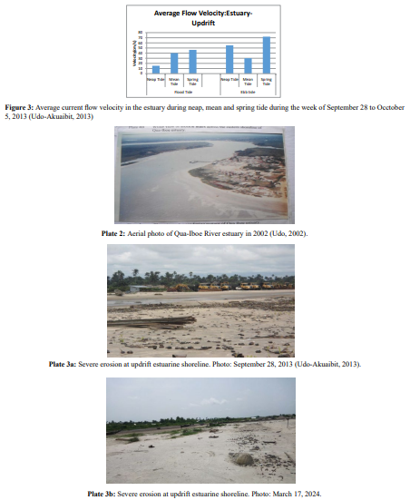
Generally, flow pattern in the estuary at both updrift and downdrift locations showed northward directed flow during flood tide and southward during ebb tide. In summary, 65.80% of current velocities in the estuary were ebb currents with an averaged velocity of 36.56cm/s due south over the flood component during neap tide. Flow pattern during mean tide depicted flood currents dominance with 52.98% of the total flow as well as an averaged flow velocity of 8.29cm/s due north. During spring tide, 54.77% of the total flow velocities in the estuary were ebb currents with an averaged flow velocity of 22.66 cm/s due south against flood currents. Precisely, flow pattern in the estuary is ebb-dominated southward (Fig.3) with meandering channel thalweg (Plates 1 and 2) which also influences erosion of the western flank of the estuary around meandering channel elbows.
Also noted in the estuary were wave diffractions during flood tides at the mouth of the estuary which propagated into the estuary and refracted towards the shoreline up to the erosion sites. The interactions of flood tidal currents with fluvial discharge at the mouth of the estuary during flood tide generated low amplitude tidal bore due to narrow estuary mouth geometry. Eventually, upstream transgression of the tidal bore due to landward retreat of the estuary mouth propelled upstream retrogradation of the meandering channel which caused erosion on the updrift estuarine shoreline. The above hydrodynamic processes were aggravated by storm surge incident of 2011 and continued till date.
Moreover, alongshore grain-size pattern depicted very well-sorted fine-grained sand with no significant correlation with the erosion sites. However, the areas of severe erosion on the shoreline may be attributed to impact of interactions of fluvial currents with flood- tidal currents around the convex region of the meandering channel thalweg contiguous to the estuarine shoreline, while accretion is associated with the concave segment of the meandering channel deflected from the shoreline.
The shoreline geometry of the estuary mouth in 2022 depicted an estimated width of over 300m while over 400m was estimated for 2024. The estuary however broadened upstream to over 500m wide with increase in distance from the mouth. The eastern flank (downdrift) of the estuarine shoreline showed two major arc- shaped erosion sites with diameters of 250m and 150m respectively at 800m and 1400m upstream of the estuary mouth (Fig.1). This above shoreline erosion was attributed to impact of low amplitude wave reflections at two consecutive elbows of meandering channel thalweg in the estuary.
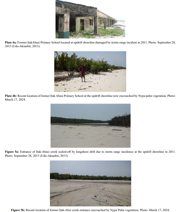
However, the 2013 edition of the map of the estuarine shoreline showed sediment accretion on the downdrift beach with the two erosion sites filled up with sediment. On the other hand, an erosion site with depression arc diameter of less than 100m was evident at a location of less than 500m off the estuary mouth at the western flank (updrift) of the estuarine beach (Fig.2) (Plate 3a.) in 2013 persisted till date (Plate 3b) while the eastern estuarine shoreline is accreting till date. Moreover, visual observations in 2024 revealed severe threat of erosion in which some of the structures left in 2013 were completely destroyed and lost to the sea with the land retrograded (Plates 4 a and b). Also, the entrance of the tidal channel (Itak-Abasi Creek) which was completely sealed-off by longshore drift in 2013 (Plate 5a) is now completely encroached by Nypa palm vegetation (Plate 5b) and the tidal channel deflected landward and meandered away from the shoreline.
The above shoreline morphodynamics pattern, which depicted persistent erosion on the western bank against the accreting eastern shoreline of the estuary over decades, leads to updrift morphodynamic offset of the shoreline. This may be an indication of sea level rise. The estuarine shoreline erosion pattern, which favoured accretion at the eastern shoreline than the western (updrift) counterpart, rendered the coastal dwellers at the western flank homeless due to a great loss of their land to the sea. However, the dwellers at the eastern flank took advantage of sediment surplus on the downdrift shoreline and embarked on sand mining for infrastructural development of their area. Therefore, in order to reclaim the land from the ocean before the sediments are reworked and transported to Calabar canyon, there is need for nearshore sand dredging and filling intervention measures to be taken at the western shoreline.

Figure 1: Map of Qua-Iboe River estuary, Ibeno, Akwa Ibom State, S.E. coast of Nigeria showing monitoring stations in 2002 (After Udo, 2002).
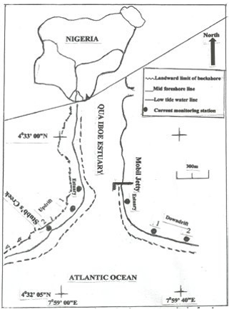
Figure 2: Map of Qua-Iboe River estuary, Ibeno, Akwa Ibom State, S.E. coast of Nigeria showing monitoring stations in 2013 (After Udo-Akuaibit, 2013).
Conclusion
Erosion is a major problem at the updrift and downdrift shoreline adjoining Qua- Iboe River estuary. The problem was aggravated by storm surge incident in 2011, with the updrift severely eroded and the downdrift accreting till date, and may be indications of sea level rise and intensification of impact of climate change. Therefore, sand filling of the updrift shoreline while the displaced coastal dwellers of Itak-Abasi fishing community are resettled upland and provided with alternative means of sustainable livelihoods by the government, multinational oil companies in the area as well as appropriate international organisations and agencies are recommended. Also, regular dredging of the estuary for beach nourishment and maintenance of the estuarine channel for navigation is essential. Moreover, there is need for awareness creation for the people in the area on intervention, adaptation and mitigation strategies to impact of climate change for their safety and coastal resilience, such as relocation and resettlement, without undermining their cultural heritage and belief [1-11].
Acknowledgement
I am sincerely thankful to Prof. E.E. Antia, Department of Physical Oceanography, University of Calabar, Calabar, Nigeria for his advice.
References
- Adegoke, J.O., M. Fageja, G.James, G. Abaje, and T.E. Ologunorisa (2010), An Assessment of Recent Changes in the Niger Delta Coastline using Satellite Imagery. Journal of Sustainable Development, 3(4)277-296.
- Antia,E.E.(1995),Tidal range-related reversal in grain size pattern on tropical sandy beaches of S.E. Nigeria. Senckenbergiana martima, 25, 147-153.
- Antia, E.E.(1998), A short- term study of the effects of the changing coastal condition on some geomorphic elements on Nigerian beaches. Zeitschrift f. Geomorphologie, 73,1-16.
- Asangwe, C.K.(1993), Issues and Problems in controlling the threats of erosion along the Nigerian coastline: coastline of West Africa (ed. Awosika,L.F. Ibe,A.C. and Shroader, P.) American Society of Civil Engineers, New York. Pg.309-324.
- Ibe, A.C.(1998), Coastal Erosion in Nigeria. Ibadan University Press, Ibadan, Nigeria.
- Short K.C., and A. J. Stauble (1967), Outline geology of the Niger Delta. American Association of Petroleum Geologists Bulletin 51: 761- 769
- Udo-Akuaibit, S.P.(2013), Analysis of nearshore flow interactions, sediment budget and offset shoreline development, adjoining Qua iboe River Estuary, S.E. Coast of Nigeria. M.Sc. Dissertation submitted to College of Graduate Studies, University of Port Harcourt, Port Harcourt, Nigeria.
- Folk, R., and W.C.Ward (1957), Brazos River bar: A study of the significance of grain size parameters . Journal of Sedimentary Petrology, 27, 3-27.
- Udo-Akuaibit, S.P.(2014), Shoreline morpho-dynamics offset at the entrance of Qua Iboe River estuary, South-East coast of Nigeria. Journal of Coastal Development.17: 391.doi: 10.4172/1410-5217.1000391
- Udo-Akuaibit, S.P.(2017), Sea-Level Rise and Coastal Submergence along the South–East Coast of Nigeria. Journal of Oceanography and Marine Research 5: 172. doi: 10.4172/2572- 3103.1000172.
- Udo,S.P. (2002), Estuarine Shoreline Erosion Dynamics: Case Study of Qua-Iboe River Estuary,S.E. Nigeria. A Research Thesis P.G.D.Coastal Zone Management, Submitted to Graduate School. University of Calabar, Nigeria.