


Review Article - (2025) Volume 3, Issue 4
The Impact of Seismic Activity for one Tectonic Plate on Another Plate (The Syrian city: Jableh, an Example)
Received Date: Mar 28, 2025 / Accepted Date: Apr 21, 2025 / Published Date: Apr 25, 2025
Copyright: ©©2025 Hazar Shtat. This is an open-access article distributed under the terms of the Creative Commons Attribution License, which permits unrestricted use, distribution, and reproduction in any medium, provided the original author and source are credited.
Citation: Shtat, H. (2025). The Impact of Seismic Activity for one Tectonic Plate on Another Plate (The Syrian city: Jableh, an Example). Eng OA, 3(4), 01-04.
Abstract
The Gaziantep and Kahramanmara�? earthquakes, which occurred at the southwestern edge of the Anatolian Plate (Panda Plate), were a major shock and surprise to the Syrian city of Jableh, located on the northeastern side of the African Plate. Although the city lies on a different tectonic plate and is approximately 250 kilometers away from the epicenters of the two earthquakes, the damage in Jableh exceeded that in cities closer to the epicenters, such as Latakia and the Cypriot Arc. In this article, we attempt to provide a kinematic understanding of the impact of large earthquakes on points of contact between two different plates.
Overall, both earthquakes had severe consequences along the shock wavelength [1]. The first occurred at 4:17 a.m. local time on February 6, 2023, with a magnitude of 7.8 on the Richter scale. Its epicenter was located west of the city of Gaziantep. Its impact extended to Syria due to its epicenter's proximity to the Syrian- Turkish border (this earthquake is considered one of the strongest earthquakes in the history of Turkey and Syria). The second occurred nine hours later, at 1:24 p.m. local time, with a magnitude of 7.5 on the Richter scale, near the city of Marash. According to preliminary estimates, the death toll from these two earthquakes in Turkey and Syria has exceeded 50,000 and over 125,000 injured, causing extensive material damage in both countries. According to the latest official statistics, the death toll in Turkey and Syria from the earthquake has exceeded 59,000, after Turkey announced a higher death toll on its territory.
Adding the latest announced figure in Syria, which is 6,000 dead, brings the total death toll in both countries to over 59,000 (there is disagreement over the exact number, and in all cases, the figure has ranged between 50,000 and 59,000)
Introduction
The Direct Impact of the Two Earthquakes
According to the Turkish Disaster and Emergency Management Authority (AFAD), the country has been hit by 9,136 aftershocks since the earthquakes struck at dawn on February 6. The latest, a 4.3-magnitude earthquake, struck Konya province in central Turkey on Friday afternoon, February 24. AFAD explained in a statement that the earthquake occurred at 5:01 PM local time in Konya province, at a depth of 7 kilometers below the surface.
No damage was reported.
Destroyed roads, winter storms, and communications outages hampered the work of the Disaster and Emergency Management Presidency (AFAD), which includes a 60,000-strong search and rescue force, 5,000 rescuers and first responders, and 30,000 volunteers.
More than 141,000 people from 94 countries also joined the rescue efforts following Türkiye's request for international assistance.
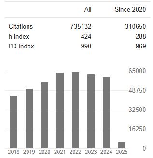
Blue Lightning (Seismic Light)
Earthquake light (Luminous phenomena of earthquakes) is a luminous atmospheric phenomenon that appears in the sky in conjunction with areas of tectonic stress or seismic activity.
It is divided into [2].
1- Pre-seismic lights: These appear seconds or weeks before an earthquake and often appear close to the epicenter.
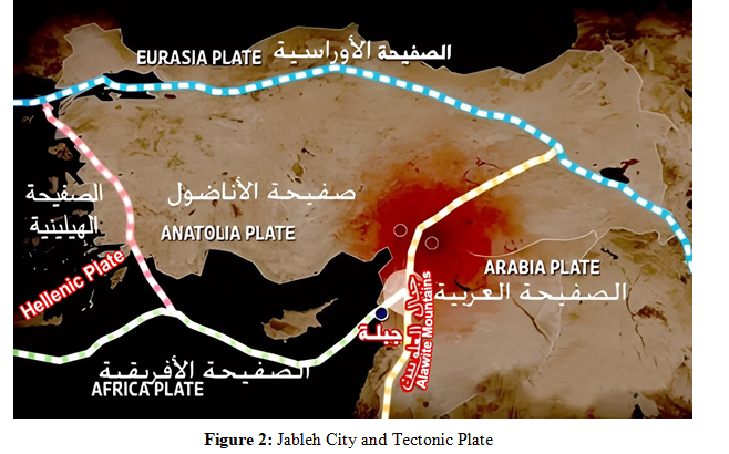
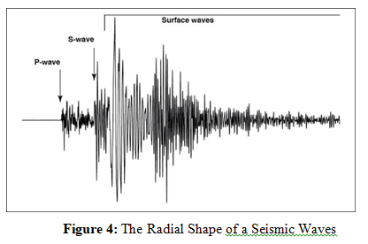
2- Synchronous lights: These appear either close to the epicenter or at distances parallel to the earthquake vector during the passage of the seismic waveform, especially during the passage of S waves (stress waves caused by ripples).
They are usually accompanied by a crackling sound emanating from the Earth's interior along the stress vector Seismic lights rarely appear during low-magnitude aftershocks. Although there is no definitive scientific explanation for seismic lights, they remain a characteristic of most large earthquakes.
The Effect of Planetary Geometry (Planetary Alignment)
On the Occurrence of Earthquakes There is no definitive evidence to support this view, despite the relative success of this prediction on rare occasions.
This can be explained statistically by the abundance of daily predictions, and vast areas covered by forecasters.
Given that the number of daily earthquakes exceeds 1,600 across the globe (including one significant earthquake every 3-4 days), this percentage may enable us to understand the validity of some of these arbitrary predictions, which may rarely be true [3].
Therefore, these vague statements about planetary geometry, along with some diagrams that may suggest to non-experts the breadth of knowledge and the veracity of the forecaster, still fall under the category of pseudoscience.
The Effect of The Earth's Magnetic and Electric Field Distortions on Tectonic Plates
There is also no direct evidence that the distortion of these two fields is a primary cause of plate movement.
The movement of plates and the stress resulting from their movement is a purely mechanical phenomenon. The distortion of magnetic and electric fields, however, is a result of mechanical movement, not the other way around [4].
The Impact of the Two Turkish Earthquakes on the Syrian City of Jableh
Tectonic plates are approximately 100 km thick and consist of two types of different compositions: the oceanic crust, rich in magnesium, and the continental crust, rich in aluminum. Scientists classify tectonic plates into three types:
- Plates with an area greater than 20 million km², called primary plates (for example, the Pacific Plate)
- Plates larger than 1 million km² and smaller than 20 million km², called secondary plates (for example, the Arabian Plate)
- Minor plates, which are plates less than 1 million km² and generally result from structural deformation in the lithosphere. These plates often led to the formation of mountains in the Precambrian era (for example, the Anatolian Plate, sometimes called the Panda Plate because its thermal cross-section resembles a panda bear).
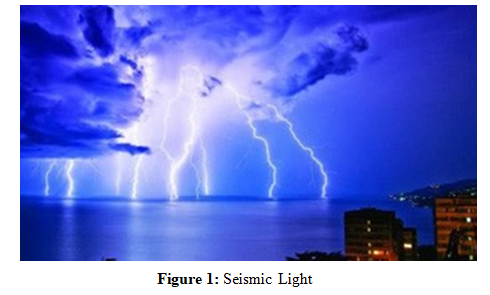
3. The Tectonic Location of Jableh, Syria Jableh is located, as shown in the attached map, at the northeastern end of the African Plate, at the contact line between the Anatolian Plate and the Arabian Plate [5].
The Alawite Mountains in the east acted as a strong natural barrier between it and the Arabian Plate.
The sea to the west also acted as a shock absorber for the Cypriot Arc and Hellenic Faults, leaving the northern flank open to the Anatolian Plate, which is considered the cause of most of the disasters that have struck Jableh throughout history.
As for faults, apart from the Cypriot Arc, there are dozens of faults located on the nearby coast, well known to fishermen.
These include Khafsa ( depression) of al-Rus, Khafsa of the head al-Buhais , Khafsa of Edward ( Ajaj) Harbour , and Khafsa of Bashkariya (about 6 km from the coast of Arab al-Malik), in addition to the Dahr al-Jarbidah Fault, which extends from Latakia in the north to the shores of Gaza.
All of these are faults that are not present on the map. We have observed some of them by diving, and others by word of mouth from ancient fishermen.
All of them are characterized - from the shore side - by the presence of the Qarous (barraq) fish at their edges and some Marmara fish, which suggests the presence of freshwater gaps beneath them (rivers and underwater springs).
In addition, the presence of the Bacalhau fish, mud monkeys, and shrimp (salt spirit) in the distant and deep places, which suggests the presence of caves with highly concentrated salt deposits.
Conclusion (from a Purely Kinematic Perspective)
The resultant Gaziantep earthquake and the KahramanmaraÃÂ?? earthquake affected the edge of the Arabian Plate to the west, while the KahramanmaraÃÂ?? earthquake directly affected the Cypriot Arc to the east and the edge of the African Plate to the north, creating instability in the region as a whole.
What happened in Jableh was a surface collapse in one of the huge salt flats. This was caused by the seismic force traveling from the direction of Al-Asaliyah toward Al-Ghazalat Street, then toward the southeast to the Al-Rihawi Building, coinciding with a secondary force toward the ring road.
This caused a double power to the original force vector [6]. This explains the massive losses incurred in the city.
Conclusion
My Team and I, believe that tremors of up to 4 and perhaps 5 magnitudes may continue throughout the eastern Mediterranean until the plates are fully restored, which, in our opinion, could take at least two to five years unless the Hellenic and Arabian plates, which are experiencing alarming activity these days, shift.
References
1. Dinçer, A. E., Dincer, N. N., Tekin-Koru, A., YaÃÂ??ar, B., & YÃÂ?±lmaz, Z. (2024). The impact of KahramanmaraÃÂ?? (2023) earthquakes: A comparative case study for AdÃÂ?±yaman and Malatya. International Journal of Disaster Risk Reduction, 110, 104647.
2. Mehdi Torabi and Morteza Fattahi , Luminous Phenomena of Earthquakes: Observations and Theories, PP2-3 , 01.2019
3. Frank Hoogerbeets, EARTHQUAKE FORECAST, Section 1,2,4
4. Haia Alsaleh, Press interview with Dr. Hazar Shtat on 09.03.2023, PP1-4, Sahibat Al-Jalalah Newspaper.
5. Topic about Tectonic Plate in Jableh city: (1) Beautiful Syria.
6. Guidio, B. P., & Jeong, C. (2021). Inversion of an Effective Seismic Force at a Domain Reduction Method (DRM) Boundary and Reconstruction of Wave Responses inside the DRM Boundary. In XLII Ibero-Latin American Congress on Computational Methods in Engineering (Vol. 3, No. 03).