
Advance in Environmental Waste Management & Recycling(AEWMR)
ISSN: 2641-1784 | DOI: 10.33140/AEWMR
Impact Factor: 0.9

Research Article - (2025) Volume 8, Issue 3
Rehabilitation of Waste Dumps of Iron Ore Running Mines in Karnataka, India: A Case Study
Received Date: Sep 02, 2025 / Accepted Date: Sep 22, 2025 / Published Date: Oct 09, 2025
Copyright: ©Â©2025 Dr. U.V. Singh. This is an open-access article distributed under the terms of the Creative Commons Attribution License, which permits unrestricted use, distribution, and reproduction in any medium, provided the original author and source are credited.
Citation: Singh, U. V. (2025). Rehabilitation of Waste Dumps of Iron Ore Running Mines in Karnataka, India: A Case Study. Adv Envi Man Rec, 8(3), 01-18.
Abstract
Due to large scale export of iron ore from State of Karnataka to Republic of China, there was spurt in production of iron ore resulted to illegal iron ore mining. The Administration (Executive and Political) was either helpless or connived with the scoundrels. This phenomenon had brought tremendous pressure on existing transport infrastructure and caused irreparable damage to ecology of the area. The demography had changed a lot. In these circumstances, the State of Karnataka ordered investigation of illegal mining through Hon’ble Lokayuktha of Karnataka by an order dated 12.03. 2007.The Hon’ble Lokayuktha submitted his reports on 18.12.2008 and 27.7.2011. A Writ Petition No. 562/2009 was filed before the Hon’ble Supreme Court of India by Samaja Parivarthana Samudaya & Others.
The Hon’ble Court directed the Central Empowered Committee (CEC) to submit factual reports in the matter of illegal mining and large-scale damage to infrastructure, environment and ecosystem of the impact area of the Karnataka State. The CEC submitted various reports in this regard and the Honorable Court issued various orders/ directions. The Honorable Court has also constituted a Monitoring Committee (MC) for E-auction of the existing stocks in the leases, illegally stored iron ore, auction of ore from the resumed mines and monitoring of implementation of RR Plans. The author is one of three members of this MC. The impact of mining activities on the overall ecology/ecosystem of the area has been discussed in this article. The lessees have implemented the approved RR Plans at their own cost. Large number of employments have been generated through implementation of RR Plans. The modalities of the rehabilitation of waste dumps which mainly involves construction of retaining wall, garland trenches, benching of dumps, levelling of dumps, laying of coir mat, watering, showing of grass seeds, planting of plant samplings, maintenance and others have been studied in detail herein.
Introduction and Background
Since the beginning of the 21st Century, the iron ore mines in India is a matter of discussion at various forums on various issues mainly for illegal mining, amendments of existing laws, intergeneration equity and many more likewise.
A turning point came to hold when State of Karnataka ordered to investigate/enquire into the illegal mining in the State through Hon’ble Lokayukta vide order No.CI:164: MMM:2006 dtd.12.3.2007 and the Central Govt constituted Justic M.B Shah Commission on enquiry into illegal mining in the country [1]. It is relevant to observe that the Hon’ble Supreme Court of India while examining the issue of illegal mining in Karnataka, Goa, Orissa, Jharkhand and other states delivered a landmark Judgement dated 18.04.2013 in WP 562 of 2009and had observed that the present is a case of mass destruction of the forest wealth of this country resulting not only in a plunder of scarce natural resources but also causing irreparable ecological and environmental damage and degradation [2,3].
That the Hon’ble Supreme Court of India, having taken cogni- zance of the Writ Petition No. 562/2009 filed by Samaja Pari- varthana Samudaya & Others based on Lokayukta reports, alleg- ing illegal mining on a large scale in Karnataka and bordering Andhra Pradesh, and having perused a number of investigative reports submitted by the Central Empowered Committee (CEC), had come to conclusion that there were large-scale illegalities and rampant damages to environment, ecology and infrastructure and more of lives of people at large in the three districts of Bellary, Chitradurga and Tumkur in the state of Karnataka. Similar obser- vations were also made for the Orissa and Goa States based on the. In a landmark judgment dated 18.04.2013 in the said WP, the Hon’ble Court had observed and held that there was rampant ille- gal mining and plundering of natural resources in the hands of a few opportunists in the State and environmental deterioration was at its lowest threshold.
Further, taking into consideration various parameters for sustainable mining, sustainable environment and equidistributional of natural resources on the principles of intergeneration equity, the Hon’ble Court, on the recommendation of the Indian Council of Forestry Research and Education (ICFRE), has fixed the Ceiling Cap for District/s in Karnataka to mitigate the pressure of mining activities on the Ecology and Environment of the area and developed devices to fix the Maximum Permissible Annual Production (MPAP) for individual leases and directed that total sum of all running mines should be within this Ceiling Cap of districts at any given time. This had brought tremendous respite to the overall ecosystem and relief to local peoples.
Meanwhile, on the recommendations of Central Empowered Com- mittee (CEC), the Hon’ble Supreme Court vide its order dated 26.08.2011 had directed the Indian Council of Forestry Research and Education (ICFRE) to conduct Macro Level Environment Im- pact Assessment (EIA) study in respect of the three districts. The ICFRE, after conducting a study in order to reduce the adverse im- pact on the ecology and environment, recommended several mea- sures including Ceiling Cap of 25.0 million metric tonnes (MMT) per year in the district of Bellary and 5.0 MMT per year in the dis- tricts of Chitradurga and Tumkur and the CEC endorsed the said recommendations to the Hon’ble Court. It had also suggested that due to deteriorated existing conditions of the internal roads as well as the external roads, lack of facilities for downhill transportation of minerals through conveyor belts, status of other infrastructure facilities such as railway siding etc., the sum total of Maximum Permissible Annual Production (MPAP) from all the mining leas- es shall be below the district-wise ceiling on production of iron ore from all the mining leases in the district/s. The Hon’ble Su- preme Court accepted the said recommendations vide orders dated 13.04.2012 and 18.04.2013.
The Hon’ble Supreme Court by their another order dated 14.12.2017, based on the, facts and figures placed before the Hon’ble Supreme Court by the respective parties, and available infrastructure in the three districts, enhanced the district/s Ceiling Cap per year (for Category ‘A’ and ‘B’ mines) to meet the demands of industries, i.e. Ceiling Cap for Bellary district was raised from existing 25.0 MMT to 28.0 MMT per year and that of Chitradur- ga and Tumkur districts from 5.0 MMT to 7.0 MMT, thereby en- hancing the total production in the three districts from then exist- ing 30.0 MMT to present 35.0 MMT. The MPAPs of C- category mines were kept out of this Ceiling Cap.
Being covered under a different legal and business regime, all the auctioned mining leases (C-category and likewise other auctioned mines) and leases located outside the three districts of Bellary, Chitradurga and Tumkur are not covered under the above- mentioned district level Ceiling Caps. The list of C-category and other auctioned leases (expired A and B mines) with their MPAP and other parameters are now under consideration of Court to bring within increased unified ceiling cap in the State.
That after having a broad discussion with the ICFRE, FIMI and likewise stake holders, the CEC had suggested a ceiling cap for the three districts to mitigate the adverse impact of the pollution in the area. The CEC had recommended two broad categories of regulations to mitigate the adverse impact of the pollution, restore the ecology and for scientific and sustainable mining. These two categories include (a) regulations to improve within the leased area including encroachments and (b) regulations outside the leased area for the impact zone. In the first category of regulations, the CEC suggested/recommended for preparation of Reclamation and Rehabilitation Plan (R&R plan) for individual lease and suggested certain guidelines.
The R&R Plan also includes the fixing of the Maximum Permissible Annual Production (MPAP). The MPAP for each mining lease should be fixed based on the (a) Reserve of ore available in that mining lease, (b) area available for active over burden/waste dumps and sub-grade iron ore dumps, (c) the transportation facilities vis-à-vis traffic load due to ore transportation and (d) adjustment of the Maximum Permissible Annual Production to the district level ceiling of the respective district. The sum of MPAPs of all running mines should not exceed the ceiling cap of that district; if it exceeds, then MPAP for each lease should be reduced on pro rata basis.
That for the areas outside the mining leases in the impact zone, the CEC has recommended implementation of a Comprehensive Environment Plan for Mining Impact Zone (CEPMIZ) for the area outside the mining leases in the Impact Zone. The CEPMIZ included (a) Biodiversity Conservationon Plan, (b) Afforestation and Soil Moisture Conservation Plan, (c) Physical Infrastructure Development Plan, (d) Social Infrastructure Development Plan, and (e) Regional Monitoring Plan and Mechanism. The said recommendations have been accepted by the Hon’ble Supreme Court in their order/s dated 13.4.2012 and 18.4.2013.
That the Ceiling Caps for the districts have been fixed by taking into consideration the Macro EIA plan of ICFRE including the then existing infrastructure, pollution load in the area and likewise factors for scientific and sustainable mining. Sustainable mining includes sustainable ecology and environment. Approval of CEPMIZ by the Hon’ble Court was quite late and thereby implementation is in the initial stages in the three districts. Except improving some small roads and establishing one Conveyor belt (conveyor belt installed by the JSW Steel Ltd.) the condition of infrastructure remains the same what it was during 2011.
Even feeding of ore to above-mentioned JSW Conveyor belt is through transportation of ore by trucks only; no conveyor belt has been established from the mining lease to the feeders of this Conveyor belt. Hence, there is not much reduction/relief in the movement of the vehicles/trucks in the Impact Zone. The condition of the roads used for transportation of iron in Chitradurga district is very poor; there have often been problems of transportation of the ore. The Monitoring Committee receives regular complaints in this regard. At one point of time, Monitoring Committee was forced to suspend the E-auction of ore belonging to two mines of Chitradurga district because of bad roads and other impediments.
It is important to note that large quantityy of iron ore are being transported daily through roads by trucks. During the year of 2021-22 about 16,87,825.0 trucks carrying 4,95,02,186.0 MTs of ores moved on the roads in impact zone. It is also observed from the data that on an average 1,05,700.00 MT to 1,58,399.00 MT iron ore are being transported from the mining leases and beneficiate plants to various consumer destinations by use of average 4825.0 trucks daily. This indicates the heavy traffic on the roads in all days. Relief of traffic can only be met by switching over the transportation of ore through Rails, Conveyor-belts and Railway sidings. This can only be achieved by implementing of CEPMIZ. Presently, transportation of a portion of ore from the NMDC Dhoni mine move through Rail.
The recommendation of the CEC in its Report dated 13.3.2012 for the methodology of fixation of MPAP in respect of individual lease for the process of implementation of the scientifically written R&R Plan was accepted by the Hon’ble Supreme Court by order dated 13.4.2012. This order of the Hon’ble Court paved the way for scientifically fixing iron ore production limits thereby ensuring scientific and sustainable mining after taking into consideration the mineral resources assessed to be available within the lease area. This also ensures environment-friendly mining and compliance with the standards stipulated under the various environmental and mining statutes.
With this background, the Hon’ble Supreme Court of India has directed the Government of Karnataka to formulate Rehabilitation and Reclamation Plans (R&R Plans) for all 166 mining leases in the mine affected districts viz., Bellary, Chitradurga and Tumkur. The task was entrusted to Indian Council of Forestry Research and Education (ICFRE), Dehra Dun, by the Government of Karnataka, vide letter No. DMG/MLS/R&R/2011-12, dated, 27.12. 2011. The ICFRE prepared the plans and approved by the Central Empowered Committee New Delhi. The full task is not yet over. While preparing R&R Plan, data such as topography, production technology, overburden dump, top soil, soil conservation measures, environmental quality etc. were collected for assessment of the existing scenario and environment to assess impacts and formulation of site-specific model R&R plans.
It is relevant to state here that each mine has a mining plan prepared and approval by the Indian Bureau of Mines. In the said plan there is provision to rehabilitate and reclaim the mine at the end of closing lease period and also to take measures during mining to keep the lease to maintain healthy environment. But due to failure in system, it has never been materialized and reached to stage as presently exist now. Further the lessees are requiring to take prior approval under the Section 2 of Forest (Conservation) Act1980 to maintain the greenery in the non-mining areas as condition but this also could not be implemented properly.
The heavy mining has changed the physical, biological and socio- economic environment in terms of land degradation and in the pro- cess large unscientific overburdens dumps have been accumulated. The planning has been aimed for topographic reconstruction with engineering and biological measures for erosion control, re-vegetation, adequate soil amendments including mycorrhizal fungi for re-establishment of nutrient cycle for sustainable restoration. The biological measures for management of overburden dumps, mine pit area, refractory sites, mine drainage, surface water, haul road etc., with suitable techniques to improve the ability and to support the vegetation growth has been incorporated with the application of organic matter, and use of geo-textile/geo-matting with ade- quate water facilities during lean seasons and requirement basis.
The biodiversity conservation of the lease area has been taken care to set aside an area of 2.0 ha or so considering the importance of the surrounding forest ecosystem in terms of its environmental services.
Suitable local floral species have been employed for restoration of the mined areas for overall ecosystem development and in long term to make use as timber, fodder, fuel wood and medicinal plants to meet the community requirement.The Forest types in the area belongs to Southern tropical dry deciduous forests according to Champion and Seth Classification 1968. The area falls under the mixed deciduous sub-classification. But as per the classification of Legris and Pascal (1982), the area comes under Deciduous climax forests. The plant resources inside and outside the mine lease area contains more than 200 species of herbs, shrubs and trees. Many of them are potential medicinal values.
Rehabilitation and reclamation plans will be useful in providing a framework and process to various target groups, the industry, regulatory agencies, the mine companies and others interested stake holders in iron ore mining for undertaking scientific rehabilitation and reclamation of mined out areas. Plans will also provide the essential insight in environmentally safe planning of mining activities in future.
The rehabilitation and reclamation program are basically aimed at developing an ecosystem with floral, faunal and soil characteristics to a certain extent similar to that of the pre-mining stage. The cost of Rehabilitation and Reclamation Plans shall have to be borne by the respective lessees. Overall, an area of about 10913.00ha. of 170 mines/leases at the cost of Rs. 362.83 crores have been spent under rehabilitation plans. The inactive dumps as identified by the Joint team in survey were taken into consideration for rehabilitation and reclamation. The height of waste dumps varies from mine to mine and measure of treatment were suggested based on height, slope and nature of the waste dumps. The angle of the slope of the dumps in some mines were found to be very steep.
The engineering structures in the restoration process have been discussed based on the hydrological condition on the micro watershed basis and compatibility of the surrounding area stability and drainage density. The plans include the enlisting of the existing and proposed engineering structures within and outside the lease areas.
The Hon’ble Supreme Court vide Judgement dated 18.04.2013 in WP 562 of 2009 set certain guiding factors/framework to be adopted for formulation of Rehabilitation and Reclamation plan.
They are: (i) broad design/specification for (a) garland drains (b) retaining walls (c) check dams (d) gully plugs and/or culverts (if required) (e) geo textile/geo matting of dumps (f) afforestation in the safety zones (g) afforestation in peripheral area, road side, over burden dumps and other areas (ii) dust suppression measures at/ for loading, unloading and transfer points, internal roads, mineral stacks etc. (iii) covered conveyor belts (if feasible) - such as downhill conveyor, pipe conveyor etc. (iv) specification of internal roads, (v) details of existing transport system and proposed improvements (vi) railways siding (if feasible) (vii) capacity building of personnel involved in the mining and environmental management (viii) rain water harvesting. In the above background this work has been taken up harvesting. In the above background this work has been taken up.
Ramanadurga Iron Ore Mine (RIOM) of M/s. Sri Kumaraswamy Mineral Exports Pvt. Ltd., Ballari numbered as ML No.2141 to mine iron ore in Ramanadurga Range of hillocks in, Sandur Taluk, Ballari District, Karnataka State over an extent of 60.80 ha. The lease was granted originally for a period of 20 years w.e.f. 24.01.1992 over an area of 82.55 ha.

Figure1: A Diagrammatic Overview of M/s SKME Pvt Ltd (ML 2141)
As per Figure-1: A Diagrammatic Overview of M/s SKME Pvt Ltd (ML 2141), the condition laid in the Forest Clearance, Govt. of Karnataka issued a corrigendum limiting the extent of mining lease to 60.80 ha [4]. Accordingly, only an area of 60.80 ha, is under mining and the entire area falls in forest land. The mining is under operations since Nov.1996.The mine is located at a distance of 4 km from State Highway SH 40, which is further 4 km from Sandur town. The nearest railway station is 7.5 Kms from the ML area. The ML falls in Survey of India Topo Sheet no 57A/8 and 57A/12. The area is bounded between latitudes N15°04’7.1”to15°04’58.1”and longitudes E76°29’57.2”to76°30’45.2”. Reclamation and Rehabilitation Plan for Ramanadurga Iron Ore Mine (RIOM),MLNo. 2141 of M/s. Sri Kumaraswamy Mineral Exports (SKME) was prepared by ICFRE during 2012 [5].
Figure 2: Open Cast Iron Ore Mine of M/s SKME Pvt Ltd (ML 2141), An Overview
Geology of the Lease
The general sequences of rock formations found within the lease area are predominantly Hematite Iron Ore with pockets/ thin layers of siliceous ore and Magnetic iron ore at the base. The top portion of iron ore deposit is covered by lateritic iron ore. It is found to occur as altered intrusive fully obliterated in nature. The Banded Iron ore formations (BHQ/BHJ/BMQ/Shale/Phyllite/etc.,) were deposited initially unconfirmable over basement complex. During regional metamorphism by the orogenic activities over geological time periods along with intrusive activities, the iron ore formations have under gone metamorphism enriching to hematite iron deposits.
Further due to weathering and leaching activity, enrichment of ore deposits might have been taken place. The entire formations including intrusive activities underwent various degree of alteration, leaching & weathering. Top portions of formations have undergone lateralization including outcropping iron ore formations. Major portion of iron ore deposit in the mining lease is friable and powdery nature. Lumps contribute less than 20%. Grade of the ore varies from 45% Fe to 62% Fe with an average grade of 53% Fe. General strike of the Ore body is NW-SE with easterly dip varying from 530 to 600. The deposit falls within the western limb of Sandor doubly plunging syncline. The sequences from top to bottom are lateritic iron ore, friable hematite iron ore, iron ore fines, siliceous iron ore, magnetitic Iron Ore and BHQ. The shapes of each type of ore within host rock were irregular but mainly form lensoidal both in dip and strike directions. Formations show banding structures.
Environmental Impacts of Open Cast Iron Ore Mining and Its Ancillary Operations
Environmental impacts of open cast iron ore mining (Figure-1) and its ancillary operations have been well studied, documented and an ample literature is also exists/available. Environmental impacts of mining arise because of various operations carried out during the process of mining such as change in land use, top soil removal, drilling and blasting, overburden dumping, mineral beneficiation, mine water pumping, toxic/contaminated waste water discharge and such others. In this regard, it is essential to discuss briefly on the extent of environmental impact caused by mining on various aspects of particular mine/s.
A. Impact on Landscape: Iron ore mines are open cast mining and in the process several changes do take place in the physical, chemical, biological and microbial properties of the mines/soils. The level of changes/degradation depends on climatic conditions and various other factors. Leaching caused to remove the nutrients released by microbiological activity due to the rainwater erosion and in the process the nutrient cycle breaks down, resulting the soil become biologically unproductive.
B. Impact on Ecology: Major impacts of mining on the local ecology can be seen in the form of removal of vegetation (flora) from the leased area during mining and other activities thereby disturbing local flora/fauna. Being open cast mining, all the vegetation shall have to scarify during the pitting, dumping, transportation, storage of ores and likewise other ancillary activities. The ecosystem that took millions of years to come to this stage, get vanished in no time. The vanished natural ecology of the leased area increases the possibilities of polluting the water in the surrounding water bodies due to leaching from overburdened dumps and allied activities during monsoon. The lack of natural ecology also impacts dust deposits on the vegetation as well as agricultural crops in the nearby surrounding villages, effect of noise and vibration due to blasting and movement of heavy vehicles can have direct impact on human beings as well as on wild animals.
C. Impact on Air Quality: The semi-arid climatic condition of the area coupled with mining activities on the top of the hills through open-cast mining, contributes to air pollution. The air velocity on hill tops is found more and act to supplement the dust pollution The society as a whole get effected the most by dust pollution. The dust is observed to be the predominant air pollutant even when the mining is not in operation. Whenever the mine is in operation, adequate measures shall have to be taken to reduce the impact of mining on air quality by introduction of wet drilling, the state-of- the-art dust suppression system, fixing permanent pipe sprinklers along the haul road in the mine lease area etc.
D. Impact on Noise and Vibration: Noise pollution by mining activities is mainly because of excavation, drilling, blasting, handling and transportation of ore and overburden and operation of processing equipment/s. The mine owners are unable to produce any information on the resultant peak particle velocity (PPV) resulting from ground vibration due to the blasting in their area as well as villages affected by mining. Vehicular movement also contributes noise pollution, the mine owners should consider the feasibly of introducing conveyor system within working areas so as to avert the noise created by the trippers and dumpers. The SKME mine is within two-three Kms (areal distance) of Dharmapura and extended Sandur town, the impact is easily noticed.
E. Impact on Water Quality: The iron ore resource area in this Sector is a part of residual hills and pediment over Dharwar group with narrow bands of resistant ridges which has poor ground water potential. Good potential of ground water is observed along structurally controlled zones. The most buffer zone pediment over peninsular gneiss, residual hills and resistant ridges/ hemiclonal ridges which acts as poor to moderate ground water potential areas, moderate to good along fractures and hemiclonal ridges along dip ward side. The depth of the working pits may touch maximum of 800m to 1000m (MSL). The water table lies at about 500m (MSL) around the villages situated 2.0 km in periphery. Therefore, there will be no ground water seepage in the working pits. The Sandur hills are characterized by gorges and steep hills with lush green vegetation broken up frequently by numerous mines.
The dumping of waste on steep slopes in the higher altitude with- out providing adequate Toe protection to withstand the earth pres- sures from the surcharge, coupled with unscientific dumping in to the flow course of natural drainage in the mine contribute to impairment/deterioration of water quality. The major impact on water pollution is due to erosion of waste dump and sub-grade dump, oil and grease, contamination of water bodies due to dis- charge of mine water/effluent and sedimentation of the local sea- sonal streams flowing through mines area. The Karnataka State Pollution Control Board observes the surface and ground water quality at regular intervals. The results show that the pH value var- ies between 8.6 (Narihalla dam back water) to 6.7 and is within the permissible limit in most of the samples. The total hardness varied between 88 to 1120 mg/l and has exceeded the permissible limit (600 mg/l). The parameters like magnesium, chloride, sulphate, nitrate, fluoride and iron were well within the permissible limits. However, calcium has exceeded the permissible limit in water samples obtained from Yeshvant Nagar (287 mg/l).
F. Impact on Soil Fertility: In the process of opencast mining, several changes occur in physical, chemical and microbiological properties of soil as a result of mining and storage. Inability to preserve topsoil is one of the basic hindrances to restoration of mined land. Soil degradation and the decline in the productive capacity of land resources is an immediate environmental and social concern. This should be controlled by arresting the suspended sediments in the run-off water and preventing air and water erosions from the waste dumps for which the mitigation measure under air pollution and water pollution are to be implemented.
G. Impact on Aquatic Life: In view of the fact that there is no perennial stream flowing across the leased areas, no fishes or other aquatic micro-flora and micro-fauna were observed. However, necessary precautions in the form of surface water management have to be taken up by the lessees to move the water to nearby natural stream which is the part of Narihalla and finally to the Narihalla dam.
H. Impact on Society: Bellary district experienced a decennial population growth rate (1991-2001) of 22 percent, which was five percent higher than the state average (17.52 percent). Agriculture was the major occupation in Bellary district before mining started. The rate of population growth of the tertiary sector (9.5 percent) due to mining to the tune of more than ten times than the primary sector (0.8 percent) has resulted in negative annual growth between 1995-96 and 2004-05 (CSO 2007) and, still reported to be steadily declining. The district’s rank in terms of per capita NDDP also increased from ninth to third making it the third richest district of Karnataka, after Bangalore Urban and Dakshina Kannada (UNDP, 2008).The growth share of tertiary sector contributed to the overall growth in terms of growth of transportation, banking, insurance, and business generated out of trade, hospitality (hotel and restaurant) and communication. Such disproportionate growth has resulted in changes in population dynamics (Mines, Minerals and People, 2005), cost of living, water scarcity, health impacts, employment opportunities, infrastructure development and increase in aspiration. No measures are taken by the lessees to improve education, health, literacy. Hence, there is an imperative need of improving education, health, literacy as well as the status of women in the surrounding areas through SPV (special purpose vehicle/ CEPMIZ).
Implimentation At Field and Discussion
The objective of this article is to study the on field results and suggest/recommend suitable engineering and biological measures for waste dump rehabilitation and reclamation of the lost ecosystem, and sustainable management of over burden dumps, surface water management, greening of mines for rejuvenation of lost biodiversity and overall land use of the mined-out area for improvement of environment and forest ecosystem, within the parameters framed by the Hon’ble Supreme Court with experts input. The rehabilitation and reclamation of waste dumps and allied structures are discussed herein, are broadly raising of (1) Engineering structures and (2) Biological measures. The lessees submit weekly their progress of implementation of RR Plan. The latest progress report of M/s SKME Pvt Ltd is stated in Table-1
Engineering Structures
Over Burden Dumps Management
Over burden dumps/waste dumps get generated in the mines due to opening and expansion of mining pits, formation of benches etc. It contains parts of soil, gravel and stones of very low-grade iron ore (Figure-3). If they are not rehabilitated properly, it results to flow of sediments and other materials into nala/stream courses, which contaminate the forest, agriculture and horticulture crops down below the mine lease area and in distant surroundings. Therefore, to stabilize the waste dumps and to protect the biodiversity, the rehabilitation and reclamation of dumps is a prerequisite. The existing dumps needs to be treated by using physical and biological measures. The details of physical engineering measures such as Construction of retaining wall (Figures-3), garland drains (Figures-4), formation of benches, and others had been carried out.
|
Progress Report Of R&R Implementation as on: 15.09.2025 |
|||||||||||||
|
Sl . N o. |
Activities |
Quantity |
Appro ximate Cost (Rs.in Lakhs ) ** |
Wheth er Series or Paralle l |
Progress |
Details of work |
Remarks |
||||||
|
S t a r t e d |
N ot St ar te d |
¼ |
½ |
¾ |
Comp leted (in %) |
||||||||
|
1 |
Engineering Measures Within Lease Area |
Completed as per the site condition |
|||||||||||
|
a |
Retaining walls at toe of waste dump R-R dry stone masonry |
RW 1 |
274 0 M |
18.50 |
Parallel |
-- |
-- |
- - |
- - |
- - |
56.3 9% |
1545 mts Completed out of 2740 mts. |
|
|
b |
RW 2 |
144 0 M |
17.50 |
Parallel |
-- |
-- |
- - |
- - |
- - |
33.3 3% |
480 mts Completed out of 1440 mts. |
||
|
c |
RW 3 |
121 5 M |
14.47 |
Parallel |
-- |
-- |
- - |
- - |
- - |
47.8 0% |
520 mts Completed out of 1215 mts. |
||
|
2 |
Engineering Measures for Surface Water Management Within Lease Area (Active Dump) |
|
|||||||||||
|
a |
Garland drain (1m bottom width, 2m top width and 1m deep in inclined chutes) |
GD-1 |
144 0 M |
38.76 |
Parallel |
-- |
-- |
- - |
- - |
- - |
54.2 4% |
781 mts Completed out of 1440 mts. |
Completed as per the site condition. |
|
b |
GD-2 |
121 5 M |
20.72 |
Parallel |
-- |
-- |
- - |
- - |
- - |
42.7 9% |
520 mts Completed out of |
Completed as per the site condition. |
|
|
c |
GD-3 |
200 M |
18.43 |
Parallel |
-- |
-- |
- - |
- - |
- - |
100.00 % |
Completed |
|
|
|
d |
GD-4 |
550 M |
4.70 |
Parallel |
-- |
-- |
- - |
- - |
- - |
100.00 % |
Completed |
|
|
|
e |
Settling tanks |
SST-1 TO SST-9 |
9 No. s |
108.00 |
Parallel |
-- |
|
|
|
- - |
100.00 % |
Completed |
Completed as per the site condition. (SST-1 & 2 Reconstruction work is Completed.SST-3 Reconstruction |
|
3 |
Engineering Measures for Surface Water Management out of the Lease Area |
|
|||||||||||
|
a |
Gully Plug |
GP-1 TO GP- 8 |
8 Nos. |
1.60 |
Series |
-- |
-- |
- - |
- - |
- - |
100.00 % |
Completed |
Completed as per the site condition. |
|
b |
Masonry Check Dam |
SMD-1 TO SMD-3 |
3 Nos. |
47.50 |
Series |
-- |
-- |
- - |
- - |
- - |
100.00 % |
Completed |
Completed as per the site condition. |
|
c |
Retailing Wall - R-R dry stone masonry RW |
RW |
1 No.( 480 M) |
30.50 |
Parallel |
-- |
-- |
- - |
- - |
- - |
100.00 % |
Completed |
Completed as per the site condition. |
|
4 |
Green Belt Development on Safety Zone Area: |
|
|||||||||||
|
d |
Strengthening , Gap & Green Belt / Safety Zone Plantation |
YES |
2.0302 Ha |
Parallel |
-- |
-- |
- - |
- - |
- - |
100.00 % |
100% Plantation Completed in the Green belt area |
|
|
|
e |
Environmental Monitoring & Watch-Ward after closure |
NA (NOW) |
-- |
-- |
-- |
-- |
- - |
- - |
- - |
-- |
Recommended for Implementation at the end of the Lease period |
|
|
|
5 |
Miscellaneous: |
|
|||||||||||
|
a |
Corner pillars |
A1 TO BP-14 |
14 Nos |
-- |
NA |
-- |
Com plete d |
- - |
- - |
- - |
100.00 % |
|
|
|
b |
DGPS reading |
A1 TO BP-14 |
14 Nos |
-- |
NA |
-- |
Co mp let ed |
- - |
- - |
- - |
100.00 % |
|
Completed as per the site condition. |
|
6 |
Engineering Measures Constructed Additional to R&R Proposed |
|
|||||||||||
|
a |
Silt Setteling Tank |
SST |
01 N o.( 15 M ) |
0.18 |
Parallel |
-- |
Co m ple ted |
- - |
- - |
- - |
100.00 % |
|
|
|
b |
Masonry Check Dam |
SMD |
1 N o. (4 8 M ) |
10.39 |
Parallel |
-- |
Co m ple ted |
- - |
- - |
- - |
100.00 % |
|
|
|
c |
Silt Setteling Tank |
SST |
01 No .(9 .2 M) |
1.66 |
Parallel |
-- |
Co m ple ted |
- - |
- - |
- - |
100.00 % |
|
|
|
d |
Retailing Wall - R-R dry stone masonry RW |
RW |
01 No .(1 46 M) |
3.08 |
Parallel |
-- |
-- |
- - |
- - |
- - |
-- |
|
|
|
7 |
As Per ICFRE R&R and IBM Proposal Engineering Measures |
|
|||||||||||
|
a |
Setteling tanks |
SST-10 & 11 |
2 N o. (2 97 M ) |
7.00 |
Parallel |
-- |
|
|
|
- - |
100. 00% |
Completed |
Completed as per the site condition. |
|
8 |
As Per ICFRE R&R and IBM Proposal Engineering Measures 2022-23 |
||||||||||||
|
a |
Garland drain (1m bottom width, 2m top width and 1m deep in inclined chutes) |
01 No. |
180 M |
10.00 |
Parallel |
-- |
Co mp let ed |
|
|
|
100. 00 % |
Completed |
Completed as per the site condition. |
|
b |
Retailing Wall - R- R dry stone masonry RW |
01 No. |
153 M |
3.00 |
Parallel |
-- |
Co mp let ed |
|
- - |
- - |
100. 00 % |
Completed |
Completed as per the site condition. |
|
9 |
As Per ICFRE R&R and IBM Proposal Engineering Measures 2023-24 |
||||||||||||
|
a |
Garland drain (1m bottom width, 2m top width and 1m deep in inclined chutes) |
01 No. |
236 M |
6.00 |
Parallel |
-- |
Co m ple ted |
|
23 6 mt s |
100. 00 % |
Completed |
Completed as per the site condition. |
|
|
b |
Retailing Wall - R-R dry stone masonry RW |
01 No. |
326 M |
13.00 |
Parallel |
-- |
Co m ple ted |
|
32 6 mt s Co |
100. 00 % |
Completed |
Completed as per the site condition. |
|
|
C |
Plantation |
Proposed as per IBM Approved MAMP (2023-24) |
A c h i e |
Cumulativ e (as on 15.04.2024) |
Plantat ion on waste dumps (in ha) |
|
|
|
|
|
|
|
|
|
1000 |
130 0 (insid e lease area- 1225 , outsi de lease area- 75) |
431,040 |
0.2115 |
-- |
-- |
- - |
- - |
- - |
100.0 0% |
|
Gap Filling in Dump, Dump slopes & Outside plantation. |
||
|
10 |
AS PER ICFRE R&R AND IBM PROPOSAL ENGINEERING MEASURES 2024-25 |
||||||||||||
|
a |
Garland drain (1m bottom width, 2m top width and 1m deep in inclined chutes) |
01 No. |
136 M |
3.50 |
Parallel |
136 m Co mp let ed as on 31. 03. 20 25 |
0 |
|
|
|
100.0 0% |
136 m Completed as on 15.03.2025 |
Garland Drain of 37 meters is also constructed during 2024-25 and it is as per the previous Approved Mining Plan. |
|
b |
Retailing Wall - R-R dry stone masonry RW |
01 No. |
155 M |
7.30 |
Parallel |
1 7 0
m |
0 |
- - |
- - |
- - |
109.6 7% |
170 mts Completed against proposed 155 mts. |
Retaining Wall of 45 meters is also constructed during 2024-25 and it is as per the previous Approved Mining Plan. |
|
C |
Plantation |
Proposed as per IBM Approve MAMP (2023- 24) |
A c h i e v e d |
Cumulativ e (as on 14.12.2024) |
Plantati on on waste dumps (in ha) |
|
|
|
|
|
|
|
|
|
1000 |
324 5 |
434285 |
0.55 |
-- |
-- |
- - |
- - |
- - |
324.5 0% |
|
Plantation carried out on D2 dump as per proposal. |
||
|
11 |
AS PER ICFRE R&R AND IBM PROPOSAL ENGINEERING MEASURES 2025-26 |
||||||||||||
|
a |
Garland drain (1m bottom width, 2m top width and 1m deep in inclined chutes) |
01 No. |
238 M |
3.50 |
Parallel |
0 |
Not Start ed |
- - |
- - |
- - |
0.00 % |
|
|
|
b |
Retailing Wall - R-R dry stone masonry RW |
01 No. |
246 M |
7.30 |
Parallel |
0 |
Not Start ed |
- - |
- - |
- - |
0.00 |
|
|
|
C |
Plantation |
Propose d as per IBM Approv ed MAMP (2025- 26) |
A c h i e v e d |
Cumulative (as on 15.09.2025) |
Plantatio n on waste dumps (in ha) |
|
|
|
|
|
|
|
|
|
1500 |
646 3 |
445723 |
0.620 |
-- |
-- |
- - |
- - |
- - |
430.8 6% |
|
Plantation on PD1 dump as per |
||
|
a |
Mining plan/Scheme |
Approval No. 'MCDR-MPC0FE/11/2023-BNG-IBM_RO_BNG' dated: 19- 11-2024. |
|
|
|||||||||
|
b |
EC |
EC NO.SEIAA338MIN2023 ON 17.10.2023 as per 2006 Notification. |
|
|
|
c |
FC |
FC Coterminous with Mining Lease, Government Order No.FEE 25 FFM 2013, Bangalore, Dated:23/01/2017. |
|
|
|
d |
CFO |
Combined Consent Order No. AW-340663, dated:15.11.2023, Valid up to 31/03/2027 |
|
|
Table 1: Progress Report Of R&R Plan Implementation as on: 15.09.2025
Stabilization of Waste Dump
In the working mines, there exists two types of waste dumps i.e. inactive and active dumps. Rehabilitation and Reclamation is being carried out for inactive dumps and partly active dumps also. The active dumps are generally in use and shall only be treated fully once they attain to finality. The active dumps which are planned for longer period, it is advisable to treat their lower half. The most of mine waste contain mainly of limonitic laterite, phyllites/shales, ferruginous clay, silt and dyke etc. There are no toxic or heavy metal content observed in these wastes which may cause to leach out and pollute the surrounding surface areas or the ground water system in catchment.

Figure 3: View of Overburden Waste Dump with Retaining Wall of The Mine of M/s JSW Ltd
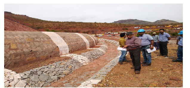
Figure 4: View of Waste Dump with Retaining Wall &Garland Trench of The Mine of M/s JSW
To stabilize a waste dump, a series of physical and biological activities had been carried out in the mine of M/s Sri Kumaraswamy Mineral Exports Pvt Ltd (ML 2141) and also M/s Jindal Steel Works Ltd (JSW). For reclamation and rehabilitation /stabilization of dumps, the measures suggested herein shall include terracing to be carried out when the slope of the dump is more than 50° within time bound program. Terracing of the dumps is must if height of dumps is more than 30.0 meter (Figure-5). This shall be followed by levelling of outer surface (Figure-6) and simultaneous watering is must for smoothening of surface. For soil binding, the levelled surface dumps shall have to be covered with Coir Mating. Synthetic matting shall be avoided.
Broadcasting of local grasses seeds is preferred. Based on the approximate slope gradient, the benches were formed and the uneven surface of the dumps were levelled with two watering. This is required for proper spreading of Coir mat. An ideal way is to use geo-textile coir mat (Figure-7). Once the mat is properly laid on the entire dump, profuse watering was done so that seeds of grasses get germinated. It was followed by seed broadcasting and planting of seedlings of suitable plant species (Figure-8). Seed broadcasting has to be taken up by using hydro seeding or by spreading slurry manually. Hydro seeding is being successfully practiced to stabilize barren steep slopes and fragile unstable surfaces in this mine. The species of seeds of grasses used in this mine is listed in Table-2 Simultaneously, the seedlings of tree species were planted (Figure-9). The tree species planted in this mine is given in Table-3 The entire process requires water, seeds, farm yard manure and mulch which are applied on the surface.
Figure 5: Benches and View of Waste Dump with Benches, of M/s SKME Pvt Ltd
|
S.No. |
Local Name |
Botanical Name |
|
1 |
Ashwagandhs seed |
Withania somnifera |
|
2 |
Henna seeds |
Lawsonia inermis |
|
3 |
Stylosanthes hamata |
Stylosanthes hamata |
|
4 |
Stylosanthes scrabra |
Stylosanthes scabra |
|
5 |
Crotoleria strighta |
Crotalaria striata |
|
6 |
Wild basil seeds |
Ocimum gratissimum or Ocimum tenuiflorum |
|
7 |
Cassia tora Seeds |
Senna tora (formerly Cassia tora) |
|
8 |
Wild kashi / Wild Sugarcane |
Saccharum spontaneous |
|
9 |
Dichathelium clandestinuam |
Dichanthelium clandestinum |
Table 2: Grass Seeds Shown on Dumps M/s Sri Kumarswamy Mineral Exports Private. Ltd [6]
In addition to hydroseeding, planting of suitable herbs, shrubs, creepers and trees have also been done on the slopes by making holes in geo-textile coir mat. For gentle slopes of dumps, benches and trenches has to be made, followed by seed broadcasting of herbs and planting of seedlings of shrubs and tree species. Tree species planted on dumps in M/s Sri Kumarswamy Mineral Exports Private. Ltd. Table-3. Planting of tree species helps in fast rehabilitation of the dumps.
|
S.No. |
Local Name |
Botanical Name |
|
1 |
Kanige/ Honge |
Pongamia pinnata |
|
2 |
Badami |
Prunus dulcis / Mangifera indica |
|
3 |
Nerale |
Syzygium cumini |
|
4 |
Seemethangadi |
Annona squamosa |
|
5 |
Aladamara |
Ficus benghalensis |
|
6 |
Cherry |
Prunus avium / Prunus cerasus |
|
7 |
Bevu |
Azadirachta indica |
|
8 |
Arali |
Ficus religiosa |
|
9 |
Bamboo |
Bambusa bambos / Dendrocalamus strictus |
|
10 |
Perale |
Psidium guajava (Guava) |
|
11 |
Basavanapaada |
Aristolochia indica |
|
12 |
Hippe |
Millingtonia hortensis |
|
13 |
Mahagani |
Swietenia mahagoni |
|
14 |
Hunase |
Tamarindus indica |
|
15 |
Jibbe |
Holoptelea integrifolia |
|
16 |
Sihi hunase |
Dialium spp. (Sweet tamarind) |
|
17 |
Bagari |
Lagerstroemia speciosa |
|
18 |
Hebbevu |
Melia dubia |
|
19 |
Aala |
Ficus benghalensis |
|
20 |
Ibbani |
Wrightia tinctoria |
|
21 |
Neermaddi |
Terminalia arjuna |
|
22 |
Halasu |
Artocarpus heterophyllus |
|
23 |
Harabevu |
Melia azedarach |
|
24 |
Seethapala |
Annona squamosa |
|
25 |
Mavu |
Mangifera indica |
|
26 |
Kamara |
Erythrina variegata |
|
27 |
Bidiru |
Bambusa bambos |
|
28 |
Jambu nerale |
Syzygium jambos |
|
29 |
Hole mathi |
Terminalia arjuna |
|
30 |
Bettada nelli |
Phyllanthus emblica |
|
31 |
Hathi |
Adansonia digitata |
|
32 |
Belada |
Aegle marmelos |
|
33 |
Challe |
Sapindus emarginatus |
Table 3: Tree Species Planted on Dumps in The Mine of M/s SKME Private. Ltd
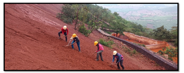
Figure 6: Levelling of Waste Dumps in M/s Sri Kumarswamy Mineral Exports Private. Ltd
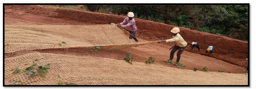
Figure 7: Spreading of Coir Mat on Dumps in M/s Sri SKME Private. Ltd

Figure 8: Application of Manure &Tree Species Planted on Dumps in M/s SKME Private. Ltd
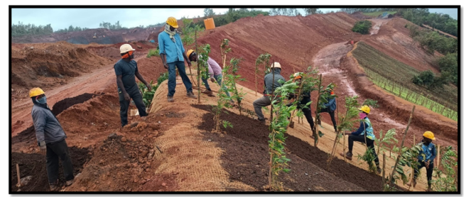
Figure 9: Tree Species Planted on Dumps in M/s M/s SKME Private. Ltd
The events/activities in sequence followed in this mining lease and M/s JSW mine has been stated here in as: (1)Construction of retaining wall and garland trench (Figure-3,4), (2)Formation of Benches (Figure-5), (3) Levelling of the dump surface (Figure-6), (4) Spreading of Coir Mat (Figure-7), (5)Seed broad casting, (6)Application of Farm yard Manure and tree planting (Figure-8,9,), (7) Planting of seedlings (Figure-9,10), Germination of seeds (Figure-11,12), (8) Fully stablished dump (Figure-13,14), (9)Regular watering and so on
All along the slope of the dumps, garland drains with bottom width of 0.5 m, top width two meter with side slope 1:2 and one-meter height should be constructed and connected to natural drain/nala. Cost effective hydroseeding is suggested for implementation with bioengineering measures especially in afforestation activities. The species suggested for seed broadcasting/hydroseeding are shown in Table -3. These species are capable of getting established in due course of time in disturbed areas. In addition to hydroseeding, planting of suitable herbs, shrubs, creepers and trees have to be done on the slopes by making holes in geo-textile coir mat. For gentle slopes of dumps, benches and trenches has to be made, followed by seed broadcasting of herbs and planting of seedlings of shrubs and tree species as suggested in Table -4 will help in reclamation of vegetation. Regular watering with local devices is must

Figure 10: Tree Species Planted on Dumps in M/s SKME Private. Ltd

Figure 11: Germination of Grasses on Coir Mat on Dumps in M/s Sri SKME Private. Ltd
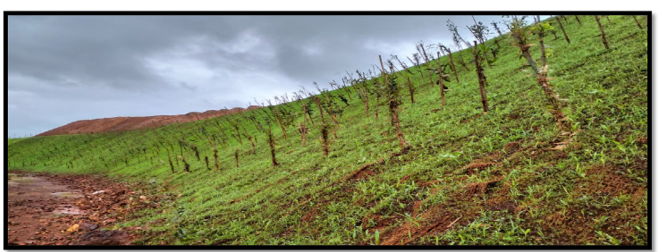
Figure 12: Stabilization of Grasses on Coir Mat on Dumps in M/s Sri SKME Private. Ltd
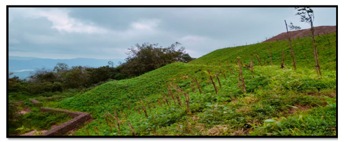
Figure 13: Fully Stabilization of Grasses on Dumps in M/s Sri SKME Private. Ltd
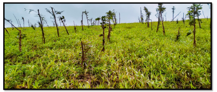
Figure 14: Fully Stabilised Dump of M/s Sri SKME Private. Ltd
Retaining Walls
A retaining wall is a structure designed and constructed to resist the lateral pressure of dump soil when there is a desired change in ground elevation that exceeds the angle of repose of the soil. A basement wall is thus one kind of retaining wall itself (Figure-3). But the term usually refers to a cantilever retaining wall, which is a freestanding structure without lateral support at its top. Retaining wall to be constructed may be of various dimensions in different places but in this mining lease the dimension of Length X 2.5 X 1.75 m with one-foot RCC at the bottom as foundation is constructed. For more clarity in the subject, the retaining wall of another lease of M/s Jindal Steel Works is also shown. (Figure-4).
Garland Drains
Suitable garland drains for the size of Length x 2m x 1m surrounding the waste dumps along the lower side of retaining walls and parallel to the mud roads had been constructed to salvage water flows and to direct to flow out of the mining area in to the valleys where the construction of check dams/settling ponds are done (Figure-4). This has prevented the accumulation of rain water within the pits and other places. Regular de-silting has been carried out, i.e., before and after monsoon season and the silt material is being used for plantation purpose.
Surface Water Management
The rainwater accumulating in the worked-out area get collected in the mining pit. After filtration, this water is pumped out for making used for dust suppression and green belt development. To facilitate, suitable garland drains and sedimentation pits/settling ponds all along the active mine areas has been constructed to prevent soil erosion and runoff.
The run-off water coming out directly from the mined-out area, temporary ore dumps, and waste over burden dumps are the sources to make the overall water turbid and also enrich heavy metals in water. Therefore, soil conservation measures had been taken to arrest siltation of all the streams/nalas around the mine areas through construction of engineering structures coupled with biological measures. In this context, engineering works such as construction of check dams and gully plugs covering such areas have been established (Figure-15,16).
All the existing drains arising from the mine area has been connected to natural streams/nalas after passing through bio- engineering structures and settling ponds. Garland trenches have been provided all along the over burden dumps, ore and sub grade ore dumps of mine to prevent soil erosion which may result in siltation of the streams. While adopting the above measures, care was taken that the aquatic faunal diversity had not get affected from the mining activity.
Masonry Check Dams
Masonry check dams of corresponding size are generally small dams which are permanently built across the minor channel(s) or drainages (Figure-15). Bigger size masonry check dams are constructed across the big channels (Figure-16) They reduce erosion and gullying in the channel and allow sediments to settle. They also lower the speed of water flow during storm events. Frequent removal of silt is being done from upper side. Check dams are built with masonry. These check dams are permanent / semi-permanent in nature. But logs, stone, or sandbags have also been used for temporary structures.
Figure 15: Small Size Masonry Check Dams Constructed Across the Nallah Outside the Lease

Figure 16: Big Size Masonry Check Dams Constructed Across the Nallah Outside the Lease
Settling Ponds
Settling ponds (Figures17) are simple ponds that collect water so diverted to them so that it can be relatively calm for a period, thereby allowing suspended solids to precipitate or "drop out" of the water. Settling ponds are basically used for impoundments for process of contaminated water derived from floating or dry land dredges or other forms of mining placers that can deposit significant amount of sediment at bottom and water reused. Impoundments for sediment laden water running off from excavated or stripped lands of leased area are designed to accumulate for percolation, infiltration, evaporation and reuse of water.
The number of Settling ponds in a lease depend on the quantity of water getting drained off. Likewise, the size of ponds also. 30m x 15m x 3m ponds are suitable size in this region. If space and suitability fits in the leased area it should be preferred within by the side of waste dumps to slow down the flow of water and to arrest the loose sediments from the waste dumps and also to store water for watering the green belt and grasses on dumps. A settling tank has been constructed near the wase dump lower side, in stone masonry and cement sand mortar 1:5 and had been plastered from inside. Regular de-silting is being carried out, i.e., before and after monsoon season and the silt material is used for plantation purpose.

Figure 17: Settling Tank for Retention of Drain Off Water Get Filled During Monsoon
Biological Measures
Over the past several years due to large-scale mining operations in the forest areas, it has resulted into substantial impact on the eco- system by way of land degradation, deforestation, disappearance of many valued species of plants, displacement of wildlife, besides adverse effect on aquatic/arboreal eco-system. Various mining activities like excavation, transportation of ore and processing of overburden’s disposal etc. have caused extensive damage to the ecosystem.
It is absolutely necessary to take appropriate measures to implement good mining practices. Apart from engineering measures, biological measures are equally essential/important. Biological measures when implemented will result in the establishment of ecosystem that will be self-sustained. As vegetation climax succeeds through succession; any hindrance due to mining causes an imbalance in nature’s operational process. To implement biological measures all the operational activity should be planned well in time. Utmost care should be taken to preserve the adjoining natural forests around the mine lease area. Activities as taken for biological measure other than the waste dumps are briefly discussed here as under.
Afforestation
The forests of Bellary sector fall under two sub-groups, namely, Southern Tropical Dry Deciduous and Southern Tropical Thorn Forests. Considering the importance of the forest ecosystem in terms of its environmental services suitable floral species are required to be planted for restoration of the mined-out areas for timber, fodder, fuel wood and medicinal plant to meet the community requirement and overall maintaining the original ecosystem.
To cater to the needs of plantation activities, the nursery may be established in each lease with the criteria of: a). Minimum of one acres of land should be reserved for setting up the nursery. b). Local people who are familiar with the local flora may be employed. c). Seeds of the species as prescribed for various purposes should be procured locally for raising the seedlings d). Unemployed youth and women may be employed in the nursery for their sustainability and income generation for the society. They should be given adequate training in nursery techniques Inoculation of microbial bacteria and fungi in the nursery stage for the planting stock will improve the growth and establishment of planting. Educated local people may be brought in for employment for planting and regular monitoring of the afforested areas. Further, for the habitat management in and around the mine lease areas must be adapted by planting suitable fodder species to enable wild herbivores to thrive upon.
Afforestation shall be carried out through: propagules (lignotubers, corms, bulbs, rhizomes and roots) stored in the topsoil; and sowing seed; Planting nursery-raised seedlings by seed dibbling. Transplants of individuals from natural areas. Transfer of undisturbed soil along with vegetation – the transfer of substantial amounts (around 1 m2 or more in area and 200–300 mm depth) of relatively undisturbed soil with its vegetation intact from natural areas could be transferred for improving the degraded soil.
Species Selection
While selecting the plant species care should be taken such that natural habitat surrounding the mine lease area is not altered. The balance between soil, microflora and the surrounding atmosphere must be maintained. The ultimate objective of biological measures is to restore the natural biodiversity occurring in and around the lease area. The native species which occur in the natural vegetational area are the ideal species to be introduced. Exotics and weedy species which colonize and invade the natural habitat shall not be planted. Naturally occurring legumes should always be preferred for their ability to improve soil fertility. The habitat improvement in and around the mine lease areas should be adopted by planting suitable fruit, fodder and shade bearing species to encourage faunal/avian/ insects’ population. Encouraging the native fauna to return to the areas cleared for mining is a fundamental part of any rehabilitation program that aims to restore a natural ecosystem which includes the important management plans for the conservation of fauna.
The grasses/ herbs/ shrubs/trees species as available locally in abundance can be used for biodiversity reclamation. For stabiliza- tion of steep slopes rows of grasses are to be planted. Clumps of grasses can be collected from adjacent and nearby areas without destroying the grass cover of the adjacent areas. This has been sug- gested since the grasses are drought tolerant and can colonize fast in low nutrient soil. Due to the presence of fibrous roots grasses can reduce soil erosion as they are the best sand binders. The im- portant grass species such as - Bothriochloa pertusa, Chrysopogon fulvus, Cymbopogon flexuosus, C. martinii, C.citratus,Cynodon dactylon, Dichanthium annulatum, Eleusine indica, Heteropogon contortus, Pennisetum pedicillatum, Saccharum spontaneum, etc.,can be used for planting in the form of slips and root stocks . It is suggested that the above grasses may be grown and multiplied in the nursery.
Importance of Leguminous Species
The Legumes play an important role in increasing the soil nitro- gen since they have symbiotic nitrogen fixing bacteria. Seeds of species like Atylosia scarabaeoides, Crotalaria albida, C. juncea, C. retusa, C. verrucosa, Indigofera cassioides, Cassia auriculata, Cassia occidentalis, Mimosa pudica, Stylosanthes fruticosa, Te- phrosia purpurea, etc., can be collected with less effort from adja- cent locations and can be used for propagation.
Management of Refractory Sites
Being dry belt, there are many patches found with lack of nutrient containing soil and vegetation. Such areas shall be re-planted with local leguminous species coupled with grasses/shrubs. To start with species like Agave americana, A. sisalana, Dodonaea viscosa, Euphorbia tirucalli, E. tortilis, Mimosa hamata, Tecoma stans, Sterculia urens etc. which have been proved successful in extreme conditions may be planted/preferred.
Rehabilitation of Mining Drainage
The rain intensity in Sandur area is very high. Therefore, the drainage systems of the mines are important component in rehabilitation. For this purpose, steps are required to be taken: (a) Proper gradient and drainage arrangement at the mine benches and over burden dumping area shall be provided. (b) After trapping the suspended solids in garland drains just below the over burden dumps, the water should be allowed to flow down the dump slopes to join natural streams/nalas through settling tank with filtration arrangements, so that all the suspended solids and sediments shall have arrested. (c) Plantation of indigenous and other economically important trees, shrubs, herbs and grasses at the point of discharge, where the mine outlet will pass through bio-engineering structures and on dumps has to be taken up, so that the sediment/silt flow will be arrested from the site and soil moisture can be maintained. The drain/nala bunds have been planted with suitable grasses, herbs, shrubs and trees, as per the list provided in table 4. At steep slopes necessary engineering and biological measures has also been carried out to prevent soil erosion.
|
S.N |
Species |
Family |
|
Species |
Family |
|
1 |
Acacia nilotica |
Mimosaceae |
12 |
Ficus racemosa |
Moraceae |
|
2 |
Agave Americana |
Agavaceae |
13 |
Heteropogon contortus |
Poaceae |
|
3 |
Agave sisalana |
Agavaceae |
14 |
Indigofera cassioides |
Fabaceae |
|
4 |
Bambusa arundinacea |
Poaceae |
15 |
Murraya paniculata |
Rutaceae |
|
5 |
Calotropis gigantea |
Asclepiadaceae |
16 |
Pennisetum pedicellatum |
Poaceae |
|
6 |
Calotropis procera |
Asclepiadaceae |
17 |
Phoenix loureiro |
Areacaceae |
|
7 |
Cassia auriculata |
Caesalpiniaceae |
18 |
Saccharum spontaneum |
Poaceae |
|
8 |
Chrysopogon fulvus |
Poaceae |
19 |
Stereospermum personatum |
Bignoniaceae |
|
9 |
Cymbopogon flexuosus |
Poaceae |
20 |
Syzygium cumini |
Myrtaceae |
|
10 |
Cymbopogon nardus |
Poaceae |
21 |
Terminalia arjuna |
Combretaceae |
|
11 |
Dendrocalamus strictus |
Poaceae |
22 |
Vitex negundo |
Verbenaceae |
Table 4: Plant species Suitable for Stabilization of Nallah/Drain Courses
Management of Haul Roads
Roads connecting to mines from the public roads are called haul roads. Their conditions are not good and caused to one of the main reasons of dust pollution., The roads must be regularly levelled and sprinkled with water to avoid dust during transportation of ore material through trucks. Tarpaulin covering during the transportation of iron ore is a must. All along the haul roads suitable fast growing avenue tree species, namely, Albizia lebbeck, Azadirachta indica, Cassia fistula, C. siamaea, Ficus benghalensis, Ficus racemosa, Gmelina arborea, Grewia tiliifolia, Muntingia calabura, Pongamia pinnata, Tamarindus indica, Tecoma stans, Thespesia populnea and Terminalia catappa in three rows on either side has been grown to suppress the noise and dust pollution.
Acknowledgement
My sincere thanks to the Indian Council of Forest Research, Dehradun for preparing R&R plans for various mines under the orders of Supreme Court. My special thanks also go to the various lessees for implementing the plans and passing on photos. My gratitude also goes to the officials of various Departments/Boards/Joint Teams/CEC and all others who also directly/indirectly contributed to improving the environment in this area.
References
- Investigation reports on illegal mining by U.V. Singh to Hon’ble Lokayuktha, Karnataka India, on 18.12.2008 and 27.07.2011.
- Honorable Supreme Court orders dated 23.9.2011, 18.04.2013 and others in WP No 562 of 2009 and SLP No 7366 of 2010.
- Reports of Joint team (appointed by Hon’ble Supreme Court of India) submitted to Supreme Court (2011to 2013).
- Progress reports of lessee M/s SKME on implementation of plans submitted to monitoring Committee from time to time.
- Rehabilitation and Reclamation plans of various mines prepared by Indian Council of Forest Research and Education, Dehradun (2012 to2021) and RR Plan of M/s SKME.
- Report dated 23.6.22 of Monitoring Committee to Justice Sudarshan Reddy Overseen Authority as appointed by Honorable Supreme Court India. and RR Plan of M/s Sri Kumarswamy Mineral Exports Private. Ltd.