

Earth & Environmental Science Research & Reviews(EESRR)
ISSN: 2639-7455 | DOI: 10.33140/EESRR
Impact Factor: 1.6

Research Article - (2026) Volume 9, Issue 2
Integrating Ecosystem Services of the Guétoya Watershed and Climate Change Adaptation into Local Planning: A Atrategic Approach Applied to the Rural Commune of Bantignel, Guinea
 , Alpha Issaga Palle Diallo 2 , Cheikh Saliou Toure 3,4 , Fatoumata Binta Sombily Diallo 2 , Ferdinand Mavoa 3,5 , Lucien Solie 2 and Saran Camara
 2Guinean Environmental Research Institute (IREG), Gamal Abdel Nasser University of Conakry, Guinea
3Department of Photovoltaic Energy, University of Labe, Guinea
4Renewable energy and laser materials research team -Alioune Diop University Bambey, Senegal
5International Chair of Mathematical Physics and Application (ICMPA), University d’Abomey-Calavi, Benin
Received Date: Apr 28, 2026 / Accepted Date: May 21, 2026 / Published Date: Jun 12, 2026
Copyright: ©2026 Marietou Diallo, et al. This is an open-access article distributed under the terms of the Creative Commons Attribution License, which permits unrestricted use, distribution, and reproduction in any medium, provided the original author and source are credited.
Citation: Diallo, M., Diallo, A. I. P., Toure, C. S., Diallo, F. B. S., Mavoa, F., et al. (2026). Integrating Ecosystem Services of the Guétoya Watershed and Climate Change Adaptation into Local Planning: A Atrategic Approach Applied to the Rural Commune of Bantignel, Guinea. Earth & Envi Scie Res & Rev, 9(2), 01-12.
Abstract
Local Development Plans (LDPs) in rural communes of Guinea still insufficiently integrate Ecosystem Services (ES) and climate change adaptation, despite their essential role in strengthening territorial resilience. This study focuses on the Rural Commune of Bantignel (300 km2; 14,032 inhabitants, including 8,221 women), located in the Fouta Djallon highlands and highly dependent on the Guétoya watershed (6,400 ha). The methodology combines cartographic analyses, satellite image processing, and participatory workshops conducted across 11 districts to assess the state of ecosystem services and the perceptions of local communities. The results reveal significant watershed degradation, characterized by 2,048 ha of residual forests, 1,344 ha of bare soils, and 704 ha of agricultural land. This degradation has resulted in the drying up of 7 out of 11 water sources and an estimated 30% decline in agricultural yields (rice and maize), thereby increasing the vulnerability of local populations, particularly women.
To address these challenges, a five-step operational model is proposed: (i) ecological diagnosis, (ii) integration of ecosystem services into sectoral policies, (iii) green budgeting, (iv) implementation of Payment for Ecosystem Services (PES) mechanisms, and (v) environmental monitoring and evaluation. The application of this model identifies a portfolio of Ecosystem-based Adaptation (EbA) actions estimated at 210 million GNF/year, considered economically relevant compared to the annual costs of inaction (15 million GNF). These preliminary estimates should, however, be further refined through feasibility studies.
Keywords
Ecosystem Services, Climate Change Adaptation, Local Planning, Watershed Management, Territorial Resilience, Ecosystem-Based Adaptation (EBA), Payment for Ecosystem Services (PES), Guinea
Introduction
The intensification of climate change and the accelerated degradation of ecosystems constitute major challenges for sustainable development, particularly in developing countries. Ecosystem Services (ES), defined as the benefits that human societies derive from ecosystems, play a fundamental role in supporting livelihoods, regulating natural cycles, and strengthening territorial resilience [1]. These services include provisioning services (water and food), regulating services (climate and hydrological regulation), supporting services (soil fertility), and cultural services. However, the degradation of these services, driven by anthropogenic pressures and climate variability, increasingly undermines socio-economic systems. Globally, biodiversity loss generates significant economic costs estimated at several trillion dollars annually [2]. In response, the ecological and economic value of ecosystem services has progressively been integrated into development policies and climate adaptation strategies.
Climate change adaptation seeks to reduce the vulnerability of natural and human systems to droughts, floods, extreme events, and natural resource degradation. Among emerging approaches, Ecosystem-based Adaptation (EbA) relies on the sustainable use of biodiversity and ecosystem services to strengthen community resilience. In this context, territorial governance and local planning play a strategic role by mobilizing public, private, and community actors through participatory and coordinated development processes. Instruments such as Local Development Plans (LDPs) are intended to organize territorial development; however, in West Africa, they still insufficiently integrate ecosystem services as a basis for adaptation, resulting in unsustainable investments and increased vulnerability. The concept of socio-ecological resilience highlights the interactions between human and natural systems and emphasizes the importance of watersheds as ecological and hydrological planning units due to their role in water regulation, soil protection, and socio-economic sustainability.
In Guinea, decentralization policies assign rural communes the responsibility for development planning through Local Development Plans (LDPs) and Annual Investment Plans (AIPs). National frameworks such as the National Economic and Social Development Plan (PNDES) and the Nationally Determined Contributions (NDCs) encourage the integration of climate and environmental concerns into these tools. Nevertheless, operational implementation remains limited, especially regarding ecosystem services and watershed-based planning. The Rural Commune of Bantignel, located in the Fouta Djallon massif and entirely included within the Guétoya watershed (6,400 ha), illustrates these challenges. The commune strongly depends on ecosystem services for its socio-economic development, yet territorial diagnosis reveals severe degradation of natural capital characterized by forest cover loss, expansion of bare soils, drying up of water sources, and increasing resource-use conflicts. Therefore, this study seeks to answer the following question: how can the Bantignel Local Development Plan be transformed into a strategic tool integrating ecosystem services and climate change adaptation? The study hypothesizes that the explicit integration of ecosystem services into territorial diagnosis, planning, and investment prioritization can strengthen territorial resilience and make Ecosystem-based Adaptation (EbA) an operational lever for local governance. The objective is thus to propose a strategic framework for integrating ecosystem services and climate adaptation into the Bantignel LDP, contributing to a replicable model of climate-sensitive local planning in the Fouta Djallon region.
Study Area
Overview of the Rural Commune of Bantignel
The Rural Commune (RC) of Bantignel is located in the administrative region of Mamou, within the prefecture of Pita, approximately 15 km from the prefectural capital. It is one of the decentralized territorial collectivities of the prefecture and is bordered to the north by Dara-Labé and Noussy, to the east by Mombéya, to the west by the urban commune of Pita and Syntaly, and to the south by Bourouwal Tappé and Kébaly.
The commune covers an area of approximately 300 km² and is administratively organized into 11 districts and 25 sectors. According to the General Population and Housing Census (RGPH, 2014), Bantignel has a population of 14,032 inhabitants, including 5,811 men and 8,221 women, compared to 16,755 inhabitants in 1996, reflecting a slight demographic decline mainly linked to rural exodus.
Located in the Fouta Djallon massif, the Rural Commune of Bantignel lies entirely within the Guétoya watershed, characterized by a dense hydrographic network and significant hydrological potential. The watershed includes several water sources, notably Bouramawel, Soulokouwol, Thialouguel, Wodjéréwol, and Thiaguiwol. The main watercourse is a tributary of the Kokoulo River, with its source located in the eastern part of the commune, locally known as “Horé Guétoya,” meaning “headwater source” in Pulaar.

Figure 1: Illustrates the Geographical Location of the Study Area, Including the Rural Commune of Bantignel and the Guétoya Watershed.
Guétoya Watershed
A zoning study of the Guétoya watershed, conducted  the UNDP/FAO/GUI 86/012 project (Agro-Pedo-Cartographic Unit), identified four representative sub-watersheds according to their geomorphological and pedological characteristics: Zone 1 (Kollagui), corresponding to the lower basin developed on subhorizontal sandstone formations; Zone 2, a hilly area located at the interface between dolerite and sandstone formations; Zone 3 (Billé – Fello Férobhé), characterized by slopes dominated by doleritic formations; and Zone 4 (Horé Guétoya), representing the upper basin and headwater area, characterized by doleritic slopes and bowal margins composed of lateritic crusts. Zones 2 and 3 generally constitute the middle basin, marked by alternating doleritic and sandstone formations.
From a pedological perspective, these zones exhibit contrasting soil characteristics. Zone 1 is dominated by poorly permeable N’dantari soils associated with grassy fallows. Zone 2 contains hansagnéré and wossouré soils, which are relatively permeable and rich in coarse materials such as gravel and lateritic debris, with shrub fallows and relatively dense settlements. Zone 3 is characterized by hansagnéré soils developed on slopes and associated with shrub vegetation. Zone 4 consists mainly of young soils formed on dolerite, located near valley heads and water sources, with human settlements concentrated in lowland areas and along bowal margins.

Figure 2: Guétoya Watershed Zoning Model
The demographic characteristics of the Rural Commune of Bantignel in 2014 are presented in Table 1, based on data from the Third General Population and Housing Census (RGPH-3).
|
N° |
Rural Commune |
Number of Villages |
Number of Households |
Population 2014 (RGPH-3) |
Density |
||
|
Men |
Women |
Total |
59 hts/km² |
||||
|
1 |
BANTIGNEL |
1100 |
5811 |
5,811 |
8,221 |
14,032 |
|
Source: INS (2014) for the 2014 population data.
Table 1: Population of the Commune of Bantignel in 2014 Based on RGPH-3 Data
The spatial characteristics of the study area, particularly the surface areas of the Rural Commune of Bantignel and the Guétoya watershed, are presented in Table 2.
|
Rural Commune of Bantignel |
|
|
Surface Area of the RCB |
300 km2 = 30,000 ha |
|
Surface Area of the Guétoya Watershed |
6,400 ha |
Table 2: Surface Area of the Rural Commune of Bantignel and the Guétoya Watershed
The Guétoya watershed is located in the Middle Guinea region, encompassing the Fouta Djallon massif and its foothills. It mainly belongs to Agro-Ecological Zone 9 (AEZ 9), known as the “Foutanian Piedmont,” characterized by relatively moderate climatic conditions, with an average minimum temperature of about 16 °C and relative humidity around 64%. This region is strategically important for water resources and differs from the other natural regions of Guinea through a climate marked by a balanced alternation between rainy and dry seasons. Annual rainfall ranges from 1,400 to 1,800 mm, while the growing season lasts between 180 and 200 days.
Geomorphologically, the area is characterized by rugged terrain with altitudes ranging from 1,000 to 1,500 m, including peaks such as Mount Loura (1,538 m) and Mount Tinka (1,425 m). The geology is dominated by granito-gneiss formations associated with weakly developed ferralitic soils, lateritic crusts resulting from bowalization processes, hydromorphic soils in valleys, and alluvial soils along watercourses. These physical and ecological characteristics strongly influence agricultural potential, socio¬economic dynamics, and ecosystem service management within the watershed. Consequently, the Guétoya watershed represents a relevant territory for experimenting with integrated environmental management approaches that could be replicated in other watersheds of the region. The geomorphological characteristics of the Fouta Djallon are illustrated in Figure 3, highlighting the rugged relief of the study area.

Figure 3: Partial View of the Fouta Djallon Relief (Source: Authors, 2026)
Natural and Socio-Economic Potential
The valorization of natural resources by local authorities in Guinea is governed by the 2005 Local Government Code, which recognizes decentralization as a key instrument of territorial governance. This framework grants commune’s responsibilities in environmental management and local development, encouraging the integration of climate vulnerability and biodiversity conservation issues into Local Development Plans (LDPs). Land use analysis based on satellite image processing identified four main spatial units: inhabited areas, agricultural zones, forest landscapes, and water bodies. The distribution of these units is illustrated in Figures 2 and 3, while their surface areas are presented in Table 3. Bare soils, particularly associated with Bowe areas and degraded surfaces, represent a significant proportion of land cover, reflecting an advanced level of environmental degradation within the watershed.
|
Land Use in Bantignel |
||
|
|
Percentage (%) |
Area (ha) |
|
Agricultural Area |
11 |
704 |
|
Forest / Forest Landscapes |
32 |
2,048 |
|
Water Bodies |
1 |
64 |
|
Inhabited Area |
35 |
2,240 |
|
Bare Soil |
21 |
1,344 |
|
Total |
100 |
6, 400 |
Table 3: Land Use Classes Resulting from Image Processing and Mapping
These results highlight a high level of watershed degradation. The limited forest cover, combined with the expansion of bare soils and bowé areas, promotes erosion processes, surface runoff, and the progressive drying up of water sources. This dynamic is further intensified by anthropogenic pressures such as bushfires and excessive wood exploitation for charcoal production, leading to habitat degradation, biodiversity loss, and changes in local climatic conditions. Together, these factors increase the vulnerability of the socio-ecological system. In addition, agricultural areas (704 ha), mainly located in lowlands, strongly depend on the hydrological regulation functions provided by upstream ecosystems. The degradation of these ecosystems therefore compromises the sustainability of agricultural activities. The evolution of this degradation over the last three decades is illustrated in Figures 4 and 5.

Figure 4: Land Use Map in 1995

Figure 5: Land Use Map in 2025
Methodology
The methodological approach, inspired by ANAFIC tools, combines spatial analysis, participatory diagnosis, and a review of local planning documents in order to address the integration of ecosystem services (ES) from the Guétoya watershed into the Bantignel Local Development Plan (LDP).
The first phase focused on the characterization of ecosystem services through a documentary review including the Bantignel LDP, monographs, climatic data, national climate strategies, ANAFIC guidelines, and scientific literature. Participatory mapping exercises were conducted across the 11 districts to identify and locate priority ecosystem services such as water sources, community forests, grazing areas, and lowlands. Ecosystem services were then classified according to the Millennium Ecosystem Assessment typology (provisioning, regulating, cultural, and supporting services), accompanied by an assessment of their importance by local populations using a gender-sensitive approach.
The second phase consisted of vulnerability assessment and Ecosystem-based Adaptation (EbA) planning, relying on climate-sensitive planning tools promoted by ANAFIC. This phase included the development of a climate vulnerability profile, participatory risk mapping, and a seasonal calendar analysis. Gender dimensions were integrated to assess differentiated access to resources, particularly for women. Adaptation options were identified, filtered, and prioritized in order to retain EbA measures, which were then translated into a planning matrix and a climate-sensitive budget for integration into the Annual Investment Plan (AIP). Monitoring and evaluation mechanisms, as well as accountability measures, were also defined.
The third phase focused on strategic formulation through the synthesis of findings into operational recommendations aimed at climate-sensitive local planning. This included the identification of priority actions and monitoring indicators adapted to the context of the Rural Commune of Bantignel.
The methodological tools mobilized for integrating climate change and gender dimensions into Local Development Plans, according to the ANAFIC approach, are presented in Table 4.
|
ANAFIC Tools |
Objective |
How to Apply It to Guétoya/Bantignel |
|
Climate Vulnerability Profile |
Identify major hazards and the most exposed areas/populations |
Map the study area to identify impacts: drying water sources, eroded slopes, and lowlands. |
|
Gender-Differentiated Analysis |
Assess how men and women are differently affected and access resources |
With 8,221 women out of 14,032 inhabitants: analyze their access to water, wood, and lowland agricultural areas. |
|
Climate Risk Mapping |
Locate climate-related risks within the communal territory |
Overlay hazards and exposed assets: for example, villages located downstream of bare soils may face flooding and erosion risks. |
|
Seasonal Climate Calendar |
Cross-analyze agricultural activities and climate variability |
Across the 11 districts: identify changes in seasonal calendars for rice cultivation, market gardening, and transhumance. |
|
Adaptation Options Analysis |
Identify and prioritize possible adaptation options |
Filter the options to retain only EbA measures: Assisted Natural Regeneration (ANR), protected areas, stone bunds, and agroforestry. |
|
EbA Planning Matrix |
Translate adaptation options into LDP/AIP actions with costs, responsible actors, and timelines |
Example: “Restore 200 ha of Guétoya riverbanks; estimated cost: 1 billion GNF; responsible actors: Rural Commune + Forestry Services; AIP 2026.” |
|
Climate- and Gender-Sensitive Budgeting |
Ensure that the AIP allocates funds to climate change and gender-related actions |
Review the Bantignel LDP: assess the percentage of the budget allocated to watershed protection compared to conventional infrastructure. |
|
Climate Change Monitoring and Evaluation Summary |
Define 3–5 simple indicators measurable by the Rural Commune |
Examples of indicators:
|
|
Accountability Mechanism |
Involve citizens in monitoring and evaluation processes |
Propose a Guétoya watershed committee: including representatives from the 25 sectors, with 50% women. |
Table 4: ANAFIC Tools for Integrating Climate Change and Gender into the Local Development Plan (LDP)
|
|
|
Impacted by |
|||||
|
|
|
Agriculture |
Forests |
Fisheries |
Water and Energy |
Transport |
Health |
|
Impacted by |
Agriculture |
|
X |
|
X |
|
X |
|
Forests |
X |
|
|
|
|
|
|
|
Fisheries |
|
|
|
X |
|
X |
|
|
Water and Energy |
X |
X |
X |
|
|
X |
|
|
Transport |
|
|
|
|
|
X |
|
|
Health |
X |
X |
X |
X |
X |
|
|
Table 5: Intersectoral Linkages of Green Interventions in Priority Sectors of the Rural Commune of Bantignel
To illustrate the relationship between ecosystem services, territorial development, and local planning, a simplified conceptual model is proposed. This model highlights the interactions between the ecosystem services of the Guétoya watershed and the local beneficiary communities, as presented in Figure 6.

Figure 6: Interactions Between the Services of the Guétoya Watershed
The structure of the conceptual model for integrating ecosystem services into local planning is presented in Figure 7.
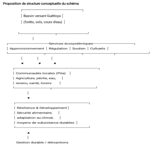
Figure 7: Conceptual Model for Integrating Ecosystem Services into Local Planning
The conceptual model is structured around four interconnected functional components illustrating the interactions between ecosystems, ecosystem services, and local communities. First, the functioning of ecosystems and the production of ecosystem services rely on different biophysical components of the watershed, including biodiversity, forests, soils, rivers, and wetlands. These ecosystems generate provisioning services (water and forest resources), regulating services (hydrological and climate regulation), supporting services (soil fertility), and cultural services. Second, the ecosystem services provided by the watershed directly contribute to the well-being of local populations by ensuring the availability of natural resources, environmental regulation processes, and socio-economic and cultural benefits such as income generation, health improvement, and recreational opportunities.
Third, the needs of local communities, linked to socio-economic activities such as agriculture, livestock farming, fishing, and water access, depend heavily on ecosystem services. Sustainable management of these resources is therefore essential for food security, climate adaptation, and the resilience of socio-ecological systems. Finally, territorial planning and sustainable management actions, particularly through the Local Development Plan (LDP), help regulate resource use, implement conservation measures, and establish monitoring and evaluation mechanisms for ecosystem services. This creates a feedback loop between ecosystem use and ecosystem preservation.
Overall, the conceptual model highlights a dynamic system in which ecosystems generate essential services for human well-being, while human activities simultaneously influence ecosystem conditions and functioning. It illustrates the continuum between biophysical components and socio-economic benefits and emphasizes the central role of territorial planning in the integration, management, and monitoring of ecosystem services. The interdependent relationships between ecosystems, ecosystem services, and human activities within the Guétoya watershed are illustrated in Figure 8.

Figure 8: Interactions and Interdependence within the Guétoya Watershed (Source: Authors, Year)
Figure 8 illustrates the interactions and interdependencies between the main components of the socio-ecological system of the Guétoya watershed. It highlights four key elements: (i) the watershed ecosystems, including forests, soils, rivers, and wetlands; (ii) the ecosystem services they generate, namely provisioning, regulating, supporting, and cultural services; (iii) local communities and their socio-economic activities such as agriculture, fishing, forest exploitation, water access, income generation, and health; and (iv) resilience and local development dynamics, including food security, climate change adaptation, and sustainable livelihoods. The diagram emphasizes the flows and interactions between these components, particularly the role of forest ecosystems in hydrological regulation, which supports downstream agricultural activities. It also highlights the positive feedback effects of sustainable ecosystem service management on the resilience of local communities. Based on this systemic analysis, a strategy for integrating ecosystem services into the Local Development Plan (LDP) is proposed through a five-step operational model.
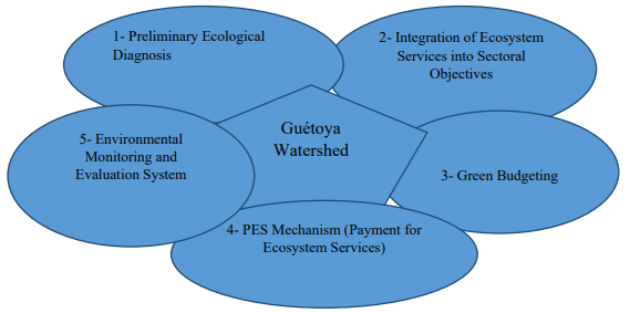
Figure 9: Strategy for Integrating Ecosystem Services into the Local Development Plan
Conditions for Success, Limitations, and Regional Lessons for the Integration of Ecosystem Services
The operationalization of the ecosystem services (ES) integration model into the Bantignel Local Development Plan (LDP) depends on three critical conditions. First, intercommunal cooperation is essential because the management of the Guétoya watershed (6,400 ha) extends beyond the administrative boundaries of Bantignel. Establishing a watershed committee involving neighboring communes is therefore necessary to ensure coherence in restoration actions, particularly for headwater protection. Without intercommunal coordination, local efforts may be undermined by upstream degradation dynamics.
Second, the integration of ES into local planning requires a transformation of municipal project management practices, shifting from conventional infrastructure investments toward ecological investments such as ecosystem restoration and assisted natural regeneration. This transition requires strengthening the technical capacities of local authorities, particularly in the design, contracting, and monitoring of ES-related actions.
Third, the acceptability of Payment for Ecosystem Services (PES) mechanisms is a key factor for success. The proposed PES mechanism, estimated at 10 million GNF per year, depends on stakeholder support and on transparent contribution and redistribution rules co-developed with local communities. Otherwise, the risk of elite capture could compromise the legitimacy and effectiveness of the mechanism.
The challenges observed in Bantignel reflect broader regional dynamics in West Africa. In Burkina Faso, the Communal Development Plans (CDPs) of the Nakambé basin illustrate the “administrative scale trap,” where interventions remain confined within communal boundaries despite hydrological dysfunctions operating at the watershed scale. Consequently, communes often prioritize corrective measures, such as reservoir dredging, without addressing deeper ecological causes due to the absence of intercommunal coordination mechanisms. In Senegal, the Communal Development Plans of the Somone basin reveal the “economic invisibility trap” of ecosystem services. In the absence of explicit economic valuation of ecosystem services, particularly the coastal protection services provided by mangroves, planning decisions tend to favor short-term profitable investments at the expense of sustainable Ecosystem-based Adaptation (EbA) solutions.
Results and Discussion
Results of Integrating Ecosystem Services into the Local Development Plan
The integration of ecosystem services (ES) into the Bantignel Local Development Plan (LDP) enables a transition from a sector-based approach to an integrated territorial approach centered on the preservation of resources that support local development. The results can be grouped into four main dimensions: environmental, socio-economic, governance, and resilience outcomes.
From an environmental perspective, the approach contributes to improved hydrological regulation through the protection of wetlands and headwater areas, resulting in reduced flooding during the rainy season and better water availability during the dry season. Erosion control is strengthened through reforestation and agroforestry practices on slopes, thereby reducing sedimentation in agricultural lowlands. In addition, biodiversity conservation is enhanced by identifying key habitats as priority conservation areas involving both technical services and local communities.
From a socio-economic standpoint, the integration of ES helps secure livelihoods linked to water resources, agriculture, livestock farming, fisheries, and non-timber forest products. It also promotes the emergence of green value chains such as honey, shea products, néré products, and ecotourism, creating new income-generating opportunities. Furthermore, the LDP contributes to anticipating and reducing conflicts over natural resource use through the establishment of management rules and stakeholder consultation mechanisms.
In terms of governance, planning becomes more strategic through budgeting processes oriented toward priority ecosystem services, facilitating access to climate finance mechanisms such as FNDL, ANAFIC, UNDP, and EU funding. The legitimacy of the commune is also strengthened, as the LDP becomes a genuine negotiation tool with technical and financial partners. Citizen participation is further enhanced through the recognition and integration of local knowledge into resource management practices.
Finally, regarding resilience, the integration of ecosystem services improves the anticipation of climate-related risks such as droughts, floods, and the drying up of water sources, allowing a shift from reactive to proactive management approaches. It also contributes to the sustainability of local infrastructures, including rural roads, boreholes, and agricultural facilities, whose effectiveness depends directly on ecosystem quality
Relevance and Contribution of the Model in Addressing Regional Challenges
The five-step model proposed for Bantignel provides concrete responses to two major constraints commonly observed in West Africa: (i) the “administrative scale trap” and (ii) the insufficient economic valuation of ecosystem services. By placing the watershed at the center of planning processes, the model goes beyond administrative boundaries and promotes an intercommunal approach. In addition, green budgeting demonstrates the economic relevance of Ecosystem-based Adaptation (EbA) solutions, with estimated investments of 210 million GNF per year compared to recurring annual costs of inaction estimated at 15 million GNF. The introduction of Payment for Ecosystem Services (PES) mechanisms also represents a major innovation by establishing financial linkages between downstream users and upstream conservation actors.
Despite these advances, several limitations remain. The main challenge lies in the temporal mismatch between the benefits of ecosystem services, which generally become visible over the medium term (3 to 5 years), and annual planning cycles. Furthermore, the proposed economic estimates remain indicative and require further in-depth studies for validation and consolidation.
Territorial Challenges
The Rural Commune of Bantignel faces several structural constraints, particularly related to its rugged topography, which promotes erosion and the isolation of production areas. Pressure on natural resources, including deforestation, exploitation of sensitive zones, and resource-use conflicts, further accelerates ecosystem degradation. These dynamics compromise ecosystem services that are essential for socio-economic development and justify the need for integrated planning at the watershed scale.
Conclusion and Recommendations
The integration of ecosystem services (ES) into local planning appears to be a relevant and necessary approach for reconciling natural resource conservation with sustainable territorial development. Applied to the Rural Commune of Bantignel, this approach has improved the understanding of local communities’ dependence on ecosystems, as well as the interactions between human activities and the ecological functioning of the Guétoya watershed. It has also contributed to identifying critical ecosystem services, assessing their level of degradation, and anticipating the risks and opportunities associated with local development. By incorporating these elements into the Local Development Plan (LDP), the commune now benefits from a strategic framework that promotes sustainable, resilient, and inclusive resource management.
To strengthen the operational implementation of this approach, several recommendations are proposed. First, ecosystem services should be systematically integrated into local planning by reinforcing the analysis of human dependencies and impacts on ecosystems within LDPs. Second, priority should be given to the identification and protection of critical ecosystems such as headwater areas, forests, and wetlands in order to better orient investments. Third, continuous monitoring mechanisms should be established to assess the evolution of ecosystem services and anticipate environmental risks.
In addition, sustainable management practices should be promoted through reforestation with local species, agroforestry, riverbank restoration, and the use of improved techniques such as improved cookstoves and organic fertilization. Economic diversification should also be encouraged by developing income-generating sectors linked to non-timber forest products, handicrafts, and ecotourism, thereby reducing pressure on natural resources. Strengthening local governance is equally essential through the establishment of natural resource management committees, clarification of access rules, and enhanced community participation. Finally, awareness-raising campaigns and capacity-building activities should be organized to encourage the adoption of sustainable environmental practices [3-19].
References
- Millennium Ecosystem Assessment (MEA). (2005). Ecosystems and Human Well-Being: Synthesis. Washington, DC: Island Press.
- Sukhdev, P., & Pushpam, K. (2008). The economics of ecosystems and biodiversity (TEEB).
- ANAFIC. (2023). Strengthening Climate Resilience in Guinea: ANAFIC Scoping Meeting with Selected NGOs for Awareness-Raising Activities. Guinea.
- Carrière, S. M. (2016). Ecosystem Services: A Concept Debated in Ecology. Scientific article, 22 p.
- Costanza, R., et al. (2013). Towards 2050: A Program for a Sustainable and Desirable Economy. Paris : Les Petits Matins/ Institut Veblen.
- Feydel, S., & Bonneuil, C. (2015). Prédation: Nature, le nouvel eldorado de la finance. La découverte.
- Germaneau, C. (2012). “The Natural Capital Declaration: A Historic International Initiative at Rio+20.” Synergiz.
- Kosmus, M., Renner, I., & Ullrich, S. (2012). Integrating ecosystem services into development planning: A stepwise approach for practitioners based on the TEEB approach. GIZ.
- Maris, V. (2014). Nature for Sale: The Limits of Ecosystem Services. Versailles : Éditions Quae.
- Mathevet, R., & Bousquet, F. (2014). Resilience and environment: thinking about socio-ecological changes . Buchet/Chastel.
- Skaalvik, J., Sevaldsen, P., & Barnes, R. (2011). Towards a green economy-pathways to sustainable development and poverty eradication.
- QUAE. (2016). Ecosystem Services: Rethinking the Relationship Between Nature and Society (pp. 53-74). Versailles: Éditions Quae.
- Republic of Guinea (Year). National Climate Change Strategy.Conakry, Guinea.
- United Nations Framework Convention on Climate Change (UNFCCC). (2019). Progress in the Process to Formulate and Implement National Adaptation Plans. Subsidiary Body for Implementation (SBI), Fifty-first Session, SBI/2019/INF.15.
- United Nations Framework Convention on Climate Change (UNFCCC). (2021). Nationally Determined Contributions under the Paris Agreement: Synthesis Report by the Secretariat.
- Girardet, L. H. (2020). United nations office for disaster risk reduction (undrr).
- United Nations Development Programme (UNDP). (2024). Climate Promise: What is Climate Change Adaptation and Why is it Crucial? February 16, 2024.
- Jimenez Hernandez, A. Guidelines for Integrating Ecosystem-based Adaptation into National Adaptation Plans: Supplement to the UNFCCC NAP Technical Guidelines.
- CGIAR. Ecosystem Services and Resilience (ESR). Available at: CGIAR ESR “Ecosystem Services: Definition, Discussion, and Limitations in Environmental Protection.”