
Earth & Environmental Science Research & Reviews(EESRR)
ISSN: 2639-7455 | DOI: 10.33140/EESRR
Impact Factor: 1.6

Research Article - (2025) Volume 8, Issue 2
Groundwater Evaluation and Borehole Failure in West Gonja District, Ghana: Insight from Geophysical and Lithological Analyses
2Ghent University, Department of Geology and Soil Sciences Laboratory for Applied Geology and Hydroge, Belgium
Received Date: Jun 07, 2025 / Accepted Date: Jul 22, 2025 / Published Date: Aug 06, 2025
Copyright: ©Â©2025 Ellen Benyarku, et al. This is an open-access article distributed under the terms of the Creative Commons Attribution License, which permits unrestricted use, distribution, and reproduction in any medium, provided the original author and source are credited.
Citation: Benyarku, E., Walraevens, K. (2025). Groundwater Evaluation and Borehole Failure in West Gonja District, Ghana: Insight from Geophysical and Lithological Analyses. Earth Envi Scie Res & Rev, 8(2), 01-10.
Abstract
The Voltaian Basin faces a persistent issue with borehole yields and unsuccessful boreholes due to its complex geological settings which affects groundwater accessibility in the areas that are underlain by this geological setting. West Gonja District, the study area faces issues of unsuccessful boreholes and low yields due to the poorly understood geology and the complexity of the Voltaian Basin. Recharge studies indicate sufficient replenishment, prompting a need to understand the causes of borehole failure. From the VES data, the results indicate that the geoelectric sections of the area is underlain by 3–5 layers: for Damongo Formation the topsoil/laterite (42.8–20704 Ωm), for the moist saprolite/mudrock/shale intercalated with sandstone (4.19– 824 Ωm), clay/intercalated sandstone (9.66–11087 Ωm) and the fresh basement (0.31–21000 Ωm). For Anyaboni Sandstone Formation and other formations, the topsoil/laterite (27.3-13002 Ωm), for the saprolite/shale/sandstone (8.03-12943 Ωm), shale/weathered sandstone (2.81–15791 Ωm), sandstone (0.825–51529 Ωm) and the fresh basement clay (0.669-16.5 Ωm). These results indicate that the Anyaboni Sandstone Formation and the other formation which are underlain predominantly by sandstone are more productive for groundwater exploration as against the Damongo Formation due to the presence of the intercalation in the sandstone which are poor and thin fractured. Deeper wells into the subsurface are not recommended in this area, especially within the Damongo Formation. During VES interpretation, layers should be increased up to 10 layers for better delineation of aquifer units and intercalations present, especially in the Damongo Formation. Unsuccessfully drilled boreholes and low yields identified within the Voltaian Sedimentary Basin are primarily caused by the complex geology as well as the interpretation of VES data during analysis.
Keywords
VES, Geophysical, Lithological, Cross Section, West Gonja, Ghana
Introduction
Groundwater evaluation of an area is essential due to increase need for potable water globally as a result of increase in population to meet domestic, industrial and agricultural purposes. Globally, it is estimated that groundwater supply for agricultural purposes is about 70% [1,2]. Also, this resource provides half of the total water drinking globally [1]. In July 28, 2010, the UN made accessibility to potable, clean water and sanitation a human right (Water for life decade, 2024). Hence, it is imperative to evaluate the availability of groundwater for a particular area or region for its exploitation. In plight of this, there has been increase in borehole development to provide potable water to help mitigate water related diseases and reduce or eliminate scarcity of water supply for domestic, industrial and irrigation purposes globally. In the Northern part of Ghana there has been increase in borehole development in recent years by the government of Ghana, non - governmental agencies, international aids and individuals. The complexities of the Voltaian Basins with regards to the hydrogeological and geological settings contributes to the low yield and failure of some boreholes in the Northern Region of Ghana [3,4]. Also, a review and research by, suggested that drying and low yield of some boreholes might have resulted from clogging of screens, inadequate well development and poor screen selection respectively [3,4]. Also, in research conducted by revealed that some of these failures can also be attributed to borehole pump breakdown [5]. However, where a hand pump had failed no work has been done to determine whether the borehole had also failed. Borehole development is expensive in Africa as well as in Ghana when compared with the cost of drilling in Asia [6]. Regardless of this, some of these developed boreholes have not been productive after its development. There are several factors that accounts for borehole failure and some of these factors include: groundwater levels depletion in weathered aquifers inadequate recharge to fractured aquifers which result in dry boreholes. Failure of boreholes occurs owing to: plugging of the formation around the well screen by fine particles; sand pumping as a results siltation, incrustation or corrosion of casing and screens; structural collapse of casing and screens, due to corrosion as a result of low-pH (acidic) and the ingress of pollutants [5]. In the study area, West Gonja District, some boreholes have failed after its development, that is, after some few days, weeks or months, some too have failed after few years of its development. Borehole failure in this regard ends up wasting the resources invested in the development of these boreholes. Hence, does not help to achieve the purpose for which it was developed for communities thus, these communities end up relying on surface water which are usually not potable for domestic, industrial and agricultural use. Also, effect of climate change has affected the annual rainfall and its pattern; uncontrolled anthropogenic activities in the available surface waters have greatly been affected hence making surface waters in the area unreliable. With persistent borehole failures which has led to potable water scarcity, this paper therefore seeks to employ the use of geophysical, litho-logged and geochemical data to investigate the causes of borehole failure and delineate the aquifer zones that underlie the West Gonja District.
And also assess the geochemical composition of some boreholes across West Gonja District to define groundwater quality. The outcome of this work would help achieve some Sustainable Development Goals set by the United Nations in 2015: 1: No poverty; 2: Zero Hunger; 3: Good health and well-being; 6: Clean Water and Sanitation. The data employ for this study include primary and secondary data which were acquired from the Community Water and Sanitation Agency in the Northern Region and World Vision International also in the Northern Region. In recent times, the use of Vertical Electrical Sounding (VES) data in characterising and evaluating groundwater potentiality has seen great success in many research works around the world such as [7-14]. During preceding years, the dipole-dipole method was applied in subsurface hydrogeological investigations in the Northern part of Ghana until recently there has been a switch tothe use of Schlumberger Vertical Sounding. The switch to use the Schlumberger Vertical Electrical Sounding (VES) electrode configuration within the area for groundwater exploration and exploitation is as a result of its suitability in sedimentary basins and complex geological terrains; and advantages: better option for vertical or depth investigation, relatively cheap, practical, non - invasive, operational and interpretational (Mgbolu et al., 2019) over the dipole-dipole electrode configuration which is also suitable for exploration in sedimentary basins and provides a long horizontal exposition but poor vertical or depth investigation [11,12,15]. Groundwater assessment and groundwater quality assessment through the use of Remote Sensing and GIS data have also increase in recent years [16-24].
The Study Area and Geology
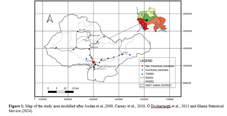
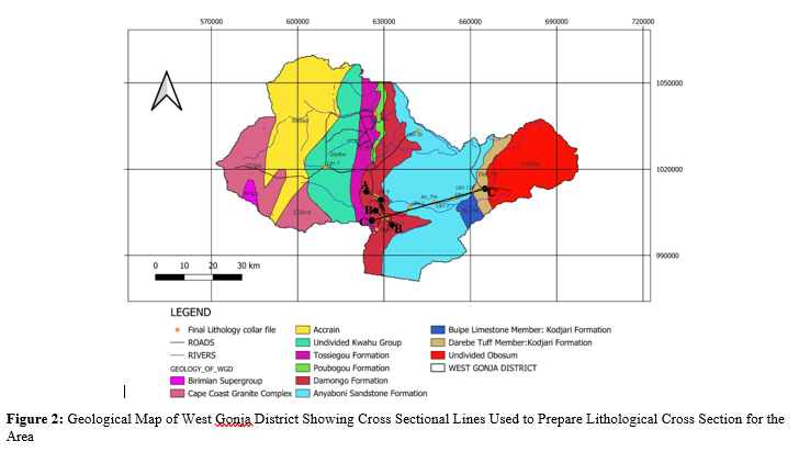
This study was done in West Gonja District which is part of the seven (7) districts within the Savannah Region of Ghana. It lies between longitude 1°5’ and 2°58’ W and latitude 8° 32’ and 10°2’ N in the Savannah Region, with its capital town being Damongo (Figure. 1). The total land area is about 4,715.9 Km2 with about 30% (1,414.77 Km2) of the land being inhabited by the Mole National Park and Kenikeni Forest Reserves. Generally, the landscape of the area is undulating with an altitude between 100 – 200 m. The Damongo Escarpment which is about 80 m and located north of the district capital is the only high land in the district [25,26]. Geologically, the study area is underlain by the complex Voltaian Sedimentary Basin and partly underlain by the Mid Devonian and isolated Cambrian rocks [4, 26,25]. The geology of the Voltaian Basin has been revised lithostratigraphically, detailing the general Upper Voltaian, Middle Voltaian and Lower Voltaian (Figure. 2) in [27-30]. The detail revised geology of the study area is established as: the Upper Voltaian: Obosum Group (Undifferentiated Obosum Group), Middle Voltaian: Oti - Pendjari Group (Darebe Member, Bimbila Formation Undivided, Buipe Member of Kodjari Formation, Basal tillite/conglomerate); Lower Voltaian: Kwahu - Morago/Boumbouako Group (Anyaboni Formation; Damongo Formation; Poubogou Formation; Tossiegou Formation and the Undivided Kwahu Group) and the Cambrian rocks: (Tamnean Plutonic suite; Birimian Supergroup and Birimian Sedimentary Group).
Materials & Methods
Data Acquisition and Processing
Data used in this work were Primary data and Secondary data. The primary data were acquired by visiting about 62 boreholes in the area, GPS coordinates and elevation of these boreholes were obtained using Garmin handheld GPS. The boreholes were grouped into two, thus, functional and non-functional boreholes. The number of functional boreholes recorded were 37 while non-functional boreholes were 25. Most of these non-functional boreholes were located within the Damongo Formation which underlie the Damongo community. Field survey was also conducted using questionnaires to gather data on when these boreholes were constructed, when it failed or started having low yield and why it failed. The secondary data were obtained from Community Water and Sanitation, Northern Region of Ghana and World Vision International, Northern Region of Ghana. Data obtained for this work include: Lithology data, VES data, available borehole data in the district and some shapefiles.
Lithological Data
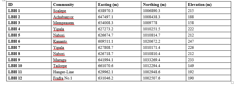
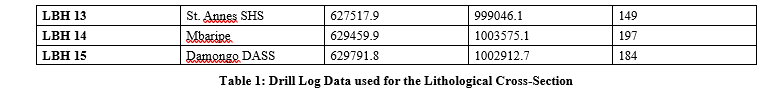
Twenty-five (25) borehole drilling data for the lithological cross section were obtained from World Vision International (WVI). Due to some logging inaccuracy and simplification in some logged data only twelve (12) drill log data (Table 1) were used for preparing cross sections in this work.
Schlumberger Vertical Electrical Sounding Data
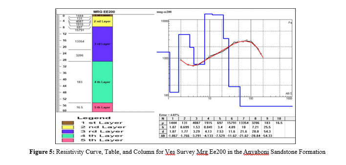
Different geoelectric resistivity tools are employed for groundwater exploration to determine the depth and thickness of groundwater around the world (Sultan et al., 2022). Sixty - six (66) Schlumberger Vertical Electrical Sounding survey data were acquired from World Vision International (WVI). The survey was conducted in fourteen (14) villages in West Gonja District. Out of the Sixty - six survey data points acquired, twenty-nine (29) data points were randomly selected base on the its spread within the district to delineate the aquifer system in the study area. The VES data were modeled, and interpreted quantitatively and qualitatively using a computerised software known as IPI2WIN. The IPI2WIN software which gives an automatic interpretation of field values (apparent resistivity (ρa) values) was used to obtain the true resistivities, thickness and depth of each layer. The apparent resistivity (ρa) and half current electrode spacing (AB/2) values were supplied into the software for each completed VES point at a given location. Data error was reduced by inversion in the computer programme. To avoid over generalisation in of the layers, all the 29 datasets were subject to ten (10) layers. This revealed the detail geology of the area especially the presence of intercalations in the geo - electric layers, which helped the final interpretation. The layers results were constrained manually per the type of curves produced from the results for each location. The 10 layers were selected to obtain more information on the rocks due to the complexity of the geology of the area, especially, the Damongo Formation. The true resistivities values were interpreted by correlating it with the available lithological data.
Results
Lithological Data Analysis
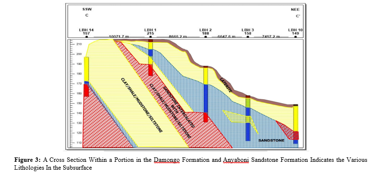
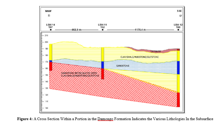
From the available lithological data four (4) cross sections have been prepared and were mainly located within the Anyaboni Sandstone Formation and the Damongo Formation as shown in Figure 3 and 4. In the cross-section preparation, zone bar logs were created to reveal the subsurface lithological description in the drillers report. The elevation orientation of the logs was subject to the mean sea level as a reference datum. Before connecting adjacent lithologies manually, the general dip amount of the fresh rocks was considered. The dip amount of the rocks in the study area is between 1° - 2° as reported by [27-29]. The mathematical expression used to generate the general trend of the dip (the vertical exaggeration) of the subsurface rocks was assumed that for every 10 km distance, there is a drop of 100 m, while the top weathered layers followed the topography of the area. The cross sections revealed the detail trend of the subsurface geology as well as the aquifer unit of the Voltaian rocks of the study area.
Subsurface Investigation using Lithological Data and Geophysical Data (VES)
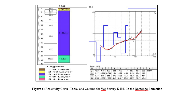
The analysis of lithological data in conjunction with Vertical Electrical Sounding (VES) data unveils the complex geology of the study area. It also highlights that the aquifer unit for the Anyaboni Sandstone Formation (Figure 3). The qualitative and quantitative analyses delineate 3 to 5 subsurface layers up to a depth between 29.68 to 88 m. In the Anyaboni Sandstone Formation, the survey points for the vertical electrical sounding analysis spans across the unit and the locations of these VES points are: Soalepe, Achunbunyor, Murugu, and Jonoponkto communities. In the Anyaboni Sandstone Formation, the surveys delineate 4 - 5 layersin the formation. The 5 - layer unit was observed from the Murugu results. While in the Damongo Formation, 4 layers were delineated from the results.
Comparison of Lithologs and VES logs
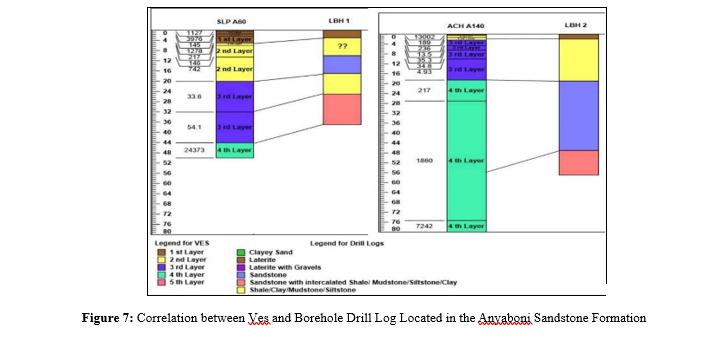
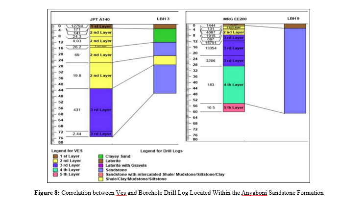
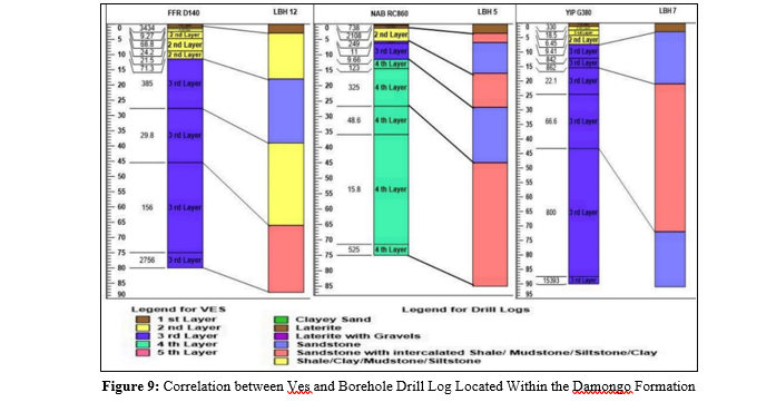
Some VES logs used in the cross sections were compared to it representative borehole logs in Figure. 7 to 9 below.
Discussion
Lithological Cross Section
The names describing the lithologies of the cross sections were generalised due to the complexity of the geology and some inaccuracies in the acquired lithological data, which enhanced the correlation of the layers. Each lithological unit were assigned a unique colour in the cross sections. Four (4) general lithological units were derived: (i) Laterite as the top soil; (ii) shale or clay or mudstone or siltstone which can either be found as weathered or fresh material; (iii) Sandstone which is also either in a weathered form or is slightly weathered to fresh material; (iv) Intercalation of shale or mudstone or siltstone or clay with sandstone.
Subsurface Investigation using Lithological Data and Geophysical Data (VES)
The Anyaboni Sandstone Formation consists of a thick sandstone layer occurring at shallow depth. The geology of the Anyaboni Sandstone Formation is not complex as compared to the Damongo and that the lithologies were continuous. The depth, thickness and continuity of the sandstone indicate that the Anyaboni Sandstone Formation is productive. In comparison, the sandstone unit at shallow depth in the cross section and the VES survey (Figure 5 and Figure 6) in the Damongo Formation is relatively discontinuous laterally, and often pinches out or transitions into an intercalated layer comprising sandstone and mudrock (shale, mudstone, siltstone, and clay). The primary aquifer of the Damongo Formation consists of sandstone intercalated with mudrock, which is situated at greater depth. Groundwater may be localized within areas where the intercalated sandstone is fractured, potentially explaining why some borehole drillings have not been successful even when located a few hundred meters away from a productive borehole. Additionally, the Damongo Formation is characterizedby thick clay or shale overburden which may pose challenges for recharge. The shale within the intercalation and the overlying shale could have impact on the hydraulic properties of the aquifer in the Damongo. The VES could delineate places where drilling could be successful and areas where drilling would be unsuccessful.
VES logs and Lithologs Comparison
Increase in number of layers for VES analysis revealed details in the intercalated beds, possible fractures and fresh layers within each log, especially, in the Damongo Formation. In Figure 9 some VES logs within the Anyaboni Sandstone Formation were correlated with their available borehole drill logs. Also, within the Damongo Formation, some VES were correlated with their representative borehole drill logs (Figures. 7, 8 and 9). Though the logging depth matched almost with the VES resistivity values in each log, the problem realised during the correlation was the drill log description.
Conclusion
As stated above, from the drill log data used for subsurface investigation and analyses, there were inconsistencies and inaccuracies in the log description which led to simplification of the layers for the cross sections produced in this work. Analysis from the cross sections produced from drill logs data and VES data reveals that the aquifer unit for the Anyaboni Sandstone Formation is purely sandstone and occurs at shallow depth. The sandstone is thick and mostly outcrops within the Anyaboni Sandstone Formation areas where it does not outcrop the overburden shale is not very thick. Comparatively in the Damongo Formation the sandstone unit that occurs at shallow depth is thin and is not laterally continues and mostly pinches out or transitions into an intercalated layer that comprises of sandstone and mudrock (shale, mudstone,siltstone and clay). The sandstone units at shallow depth in the Damongo Formation are not the primary aquifer, rather water is pumped from the intercalated sandstone which occurs at greater depth, mostly 40 m and above. At that depth, the rock is mostly fresh and that groundwater might be localised within areas where the intercalated sandstone is fractured and this might account for the reason why some drillings have not been successful even few hundreds of meters away from a successful borehole. Also, there is thick clay or shale overburden in the Damongo Formation and might possibly have problems with recharge. The VES reveals the complexity of the geology in the Damongo Formation. The geo-electric layer’s ranges from 3 to 5. The lateritic topsoil was thin with resistivity values ranging from 42.8 â?¦m to 14474 â?¦m and with thicknesses from 0.87 m to 1.48 m. The VES revealed thick layer of sandstone intercalated with shale. The intercalated sandstone occurred at varying depths ranging from 2.69 m to 30.6 m with thicknesses ranging from 22 m to more than 80 m. The sandstones within the intercalation in some VES stations had low resistivity values between 105 â?¦m – 156 â?¦m resulting possibly from fracturing or weathering of some part of the high resistive sandstones and were the primary aquifer. However, in most places the sandstones had relatively high resistivity values (209 â?¦m – 11087 â?¦m) indicating that they were slightly weathered or fresh. Drilling boreholes in such areas could be unsuccessful. The intercalated sandstones were also overlaid by shale with thicknesses varying from 5.86 m to 17.8 m. The shale within the intercalation and the overlying shale could have impact on the hydraulic properties of the aquifer in the Damongo. The VES could delineate places where drilling could be successful and areas where drilling would be unsuccessful.
In the Anyaboni Sandstone Formation, the VES revealed 3 to 5 geo-electric layers. The sandstone is very thick with thickness ranging from 15.05 m to 60.49 m. The sandstone occurred at depth ranging from 5.05 m to 71 m. The weathered or fractured portion of the sandstone serves as the primary and was mostly shallow. The geology of the Anyaboni Sandstone Formation is not complex as compared to the Damongo and that the lithologies were continuous. The depth, thickness and continuity of the sandstone indicate that the Anyaboni Sandstone Formation is productive [31-34].
Recommendations
From the study the following are recommended:
- There should be well organised database for third party usage
- There should be generalised code for the various lithologies for easy description and drill logging must be done by a geologist or a trained specialist
- Borehole drillings should not be sited very close to each other, especially within the Damongo Formation due to the continuity of the aquifer zone
- VES and other geophysical surveys performed to assess groundwater should be planned very well before executing them on the field. They must spread uniformly across the area under study for better delineation
- Due to the complexity of the Voltaian, during VES interpretation, minimum layers for each VES survey should be increased up to 10 layers for better delineation of aquiferunits and intercalations present especially in the Damongo Formation
- Acknowledgements
References
- National Groundwater Association. (2016). Facts about glob- al groundwater usage. National Ground Water Association, http://www. ngwa. org/Fundamentals/Documents/global- groundwater-use-fact-sheet. pdf.
- FAO, U. (2016). Global diagnostic on groundwater governance. Food and Agricultur e Organization, Rome, Italy.
- John Apambilla, A. K. U. D. A. G. O., Larry Pax, C. H. E. G.B. E. L. E. H., Makoto, N. I. S. H. I. G. A. K. I., Nukunu A,N. A. N. E. D. O., Anthony, E. W. U. S. I., & Kwabena, K.Y. (2009). Borehole Drying: A Review of the Situation in the Voltaian Hydrogeological System in Ghana. Journal of Water Resource and Protection, 2009.
- Attandoh, N., Yidana, S. M., Abdul-Samed, A., Sakyi, P. A., Banoengakubo, B., & Nude, P. M. (2013). Conceptualization of the hydrogeological system of some sedimentary aquifers in Savelugu–Nanton and surrounding areas, Northern Ghana. Hydrological Processes, 27(11), 1664-1676.
- Harvey, P. A. (2004). Borehole sustainability in rural Africa:an analysis of routine field data.
- Carter, R., Belete, E., Berhe, E., Defere, E., Horecha, D., & Negussie, Y. (2006). Reducing the costs of borehole drilling in Africa: insights from Ethiopia. WATERLINES-LONDON-, 25(1), 7.
- Arshad, M., Cheema, J., & Ahmed, S. (2007). Determination of Lithology and Groundwater Quality. 9(1560-8530), pp. 143-146.
- Nwosu, L., Ekine, A., & Nwankwo, C. (2013). Geoelectric survey for mapping groundwater flow pattern in Okigwe District, Southeastern Nigeria. British Journal of Applied Science & Technology, 3(3), 482-500.
- Okolie, E. C., & Akpoyibo, O. (2012). Investigation of subsurface lithology and prolific aquifer using VES in Edjekota, Delta State, Nigeria. International Journal of Research and Reviews in Applied Sciences, 12(3), 468-476.
- Oborie, E., & Nwankwoala, H. O. (2012). Relationships between geoelectrical and groundwater parameters in parts of Ogbia, Bayelsa Sate, Central Niger Delta.
- Nejad, H. T., Mumipour, M., Kaboli, R., & Najib, O. A. (2011). Vertical electrical sounding (VES) resistivity survey technique to explore groundwater in an arid region, southeast Iran.
- Coker, J. O. (2012). Vertical electrical sounding (VES) methods to delineate potential groundwater aquifers in Akobo area, Ibadan, South-western, Nigeria. Journal of Geology and Mining Research, 4(2), 35-42.
- Loke, M. H., Chambers, J. E., Rucker, D. F., Kuras, O., & Wilkinson, P. B. (2013). Recent developments in the direct- current geoelectrical imaging method. Journal of applied geophysics, 95, 135-156.
- Umoren, E., Agbasi, O., & Emmanuel, E. (2017). Evaluation of Ground Water Potential in Ekpri-Ikang, Bakassi LocalGovernment Area, Cross River State, Nigeria.“A Case Study of Open Bible Standard Church Premises.”. International Journal of Advanced Geosciences, 5(1), 26.
- Hermawan, O. R., & Putra, D. P. E. (2016). the effectiveness of wenner-schlumberger and dipole-dipole array of 2d geoelectrical survey to detect the occurring of groundwater in the gunung kidul karst aquifer system, Yogyakarta, Indonesia. Journal of Applied Geology, 1(2), 71-81.
- Sander, P., Chesley, M. M., & Minor, T. B. (1996). Groundwater assessment using remote sensing and GIS in a rural groundwater project in Ghana: lessons learned. Hydrogeology Journal, 4, 40-49.
- Babiker, I. S., Mohamed, M. A., Hiyama, T., & Kato, K. (2005). A GIS-based DRASTIC model for assessing aquifer vulnerability in Kakamigahara Heights, Gifu Prefecture, central Japan. Science of the Total Environment, 345(1-3), 127-140.
- Nas, B., & Berktay, A. (2010). Groundwater quality mapping in urban groundwater using GIS. Environmental monitoring and assessment, 160, 215-227.
- Forkuor, G., Pavelic, P., Asare, E., & Obuobie, E. (2013). Modelling potential areas of groundwater development for agriculture in northern Ghana using GIS/RS. Hydrological sciences journal, 58(2), 437-451.
- Kaliraj, S., Chandrasekar, N., Peter, T. S., Selvakumar, S., & Magesh, N. S. (2015). Mapping of coastal aquifer vulnerable zone in the south west coast of Kanyakumari, South India, using GIS-based DRASTIC model. Environmental monitoring and assessment, 187, 1-27.
- Hussein, A. A., Govindu, V., & Nigusse, A. G. M. (2017). Evaluation of groundwater potential using geospatial techniques. Applied Water Science, 7, 2447-2461.
- Tolche, A. D. (2021). Groundwater potential mapping using geospatial techniques: a case study of Dhungeta-Ramis sub- basin, Ethiopia. Geology, Ecology, and Landscapes, 5(1), 65- 80.
- Zhang, R., Wu, J., Yang, Y., Peng, X., Li, C., & Zhao, Q. (2022).A method to determine optimum ecological groundwater table depth in semi-arid areas. Ecological Indicators, 139, 108915.
- RaduloviÃÃÃÂ????, M., Brdar, S., Mesaroš, M., LukiÃÃÃÂ????, T., SaviÃÃÃÂ????, S., Basarin, B., ... & PaviÃÃÃÂ????, D. (2022). Assessment of groundwater potential zones using GIS and fuzzy AHP techniques—a case study of the titel municipality (Northern Serbia). ISPRS International Journal of Geo-Information, 11(4), 257.
- Ghana Districts. (2024). http://westgonja.ghanadistricts.gov.gh/. Accessed on April 17, 2024.
- Ghana Statistical Service. (2024). Population and Housing Census, West Gonja: Accessed on April 17, 2024.
- Jordan, C. J., Carney, J. N., Thomas, C. W., & McDonnell, P. (2009). Ghana airborne geophysics project in the Volta and Keta Basin: BGS final report.
- Carney, J. N., Jordan, C. J., Thomas, C. W., Condon, D. J., Kemp, S. J., & Duodo, J. A. (2010). Lithostratigraphy, sedimentation and evolution of the Volta Basin in Ghana. Precambrian Research, 183(4), 701-724.
- O Dochartaigh, B. E., Davies, J., Beamish, D., & MacDonald,A. M. (2011). BGS Consultancy: UNICEF IWASH Project, Northern Region, Ghana. Final report.
- Carrier, M. A., Boyaud, C., Lefebvre, R., & Asare, E. (2011). Hydrogeological Assessment Project of the Northern Regions of Ghana (HAP): final technical report: Hydrogeological Assessment of the Northern Regions of Ghana.
- Sattar, G. S., Keramat, M., & Shahid, S. (2016). Deciphering transmissivity and hydraulic conductivity of the aquifer by vertical electrical sounding (VES) experiments in Northwest Bangladesh. Applied Water Science, 6, 35-45.
- Stuyfzand, P. J. (1989). A new hydrochemical classification ofwater types. Iahs Publ, 182, 89–98.
- United Nations Department of Economic and Social, n.d. The human right to water and sanitation.
- West Gonja Municipal Assembly. (2024). West Gonja Municipal Assembly-Development Associati