
International Journal of Aerospace Science, Technology and Engineering(IJASTE)
ISSN: 3068-4536 | DOI: 10.33140/IJASTE


Research Article - (2025) Volume 1, Issue 1
Celestial Correspondence and Geometric Patterning: The Pleiades And the Bosnian Valley of The Pyramids
Received Date: Apr 14, 2025 / Accepted Date: May 27, 2025 / Published Date: Jun 02, 2025
Copyright: ©Â©2025 Sam Osmanagich. This is an open-access article distributed under the terms of the Creative Commons Attribution License, which permits unrestricted use, distribution, and reproduction in any medium, provided the original author and source are credited.
Citation: Osmanagich, S. (2025). Celestial Correspondence and Geometric Patterning: The Pleiades and the Bosnian Valley of the Pyramids. Int J Aerosp Sci Technol Engg, 1(1), 01-12.
Abstract
This article investigates potential spatial correspondences between the astronomical configuration of the Pleiades star cluster and the distribution of summit points in the Bosnian Valley of the Pyramids. Drawing on LiDAR-based topographic data and comparative archaeoastronomical methods, the study examines straight-line alignments, triangular relationships, and spiral geometries embedded within the terrain. Key linear configurations include Taygeta– Maia–Alcyone and Moon–Earth–Dragon, as well as Electra–Alcyone–Pleione and Sun–Love–Dragon. The triangular arrangement formed by Maia–Electra–Merope is evaluated in evaluated in relation to the terrestrial triangle formed by the Sun, Moon, and Dragon pyramids. The Pleiades star cluster has held significant symbolic, agricultural, and calendrical meaning in ancient cultures across the globe, including those of the Maya, Ancestral Puebloans, Japanese, Maori, and Greeks. By integrating landscape geometry with stellar projection, the article offers a neutral, data-based framework for interpreting ancient spatial planning through cosmological reference models. All interpretations are supported by geodetic measurements, aerial survey data, and peer-reviewed sources.
Keywords
Bosnian Valley of the Pyramids, Pleiades, Archaeoastronomy, Spatial Alignment, Triangulation
Introduction
Across continents and cultures, the Pleiades star cluster— commonly known as the Seven Sisters—has played a central role in shaping the cosmologies, calendars, and symbolic systems of ancient peoples. Located in the constellation Taurus and visible to the naked eye, the Pleiades have long been recognized not only as a navigational and seasonal marker, but also as a deeply encoded mythological motif.
In Greek tradition, the Pleiades were the daughters of Atlas and Pleione, pursued across the sky by Orion. In Vedic cosmology, they are the Ká¹?ttikÃÂ?ÂÂ, foster mothers of the war god Skanda and bearers of the sacred fire. Among the MÃÂ?ÂÂori, they appear as Matariki, signaling the beginning of the new year. The Maya timed agricultural rituals to their heliacal rising, while the Ancestral Puebloans (Anasazi) oriented architectural features to their appearance on the horizon. In Japan, the cluster is known as Subaru—meaning “to unite”—and is symbolically embedded in both folk stories and contemporary iconography.
These widespread references, often involving seven luminous entities though only six are consistently visible, point to a shared ancient fascination with the Pleiades’ compact geometry and seasonal precision. Their visual clarity and prominence in the winter sky made them a reliable celestial anchor for both ritual timekeeping and symbolic narrative structures [1].
This article explores whether similar symbolic or geometric inspiration may be embedded in the layout of summit points within the Bosnian Valley of the Pyramids. While no written records or oral traditions explicitly connect the Visoko region to the Pleiades, the spatial distribution of features—especially when viewed from an eastward orientation—invites comparison with the angular layout of stars such as Taygeta, Maia, Alcyone, Electra, and Merope [2].
Rather than proposing a definitive causal link or intent, this study adopts a neutral, measurement-based approach, examining terrestrial alignments, triangular arrangements, and spirals using LiDAR, topographic, and geodetic datasets. The aim is to determine whether non-random geometric correspondences exist between the Bosnian valley features and stellar configurations of the Pleiades, and to contextualize such observations within a broader archaeoastronomical framework [3].
The Pleiades in Astronomical Context
The Pleiades (Messier 45) is one of the closest and most studied open star clusters visible from Earth. Located in the constellation Taurus, the cluster lies at an approximate distance of 440 light- years, according to measurements made with the Hubble Space Telescope’s Fine Guidance Sensors (FGS) [4]. These sensors tracked the subtle parallax shift in the positions of three Pleiades stars over a 2.5-year period, observing from opposite sides of Earth’s orbit to refine distance estimates to within a small margin of error [5].
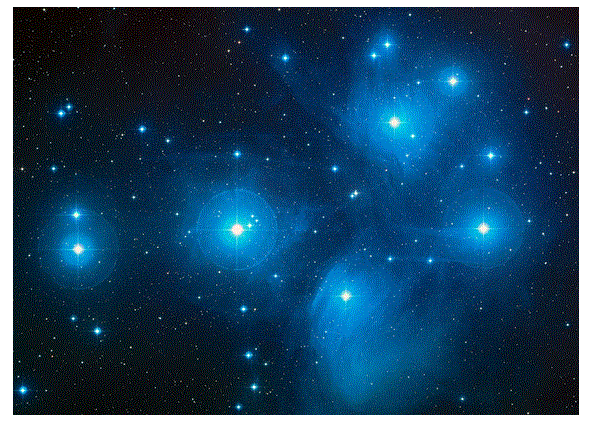
Figure 1: Composite wide-field astronomical image of the Pleiades star cluster (Messier 45), showing major stars surrounded by nebulous reflection clouds. The seven brightest stars—Alcyone, Maia, Electra, Merope, Taygeta, Celaeno, and Sterope—are visible at center. The image captures high-energy blue starlight reflecting off interstellar dust. Image courtesy of NASA/ESA Digital Sky Survey.
The cluster consists of over 1,000 known stars, although typically six or seven are visible to the unaided eye, depending on sky conditions. The most prominent stars—Alcyone, Maia, Electra, Merope, Taygeta, Celaeno, and Sterope—form a compact and asymmetrical configuration that has inspired symbolic and navigational systems across cultures. These stars are young, with an estimated age of about 100 million years, and they share a common origin and trajectory through the Milky Way [6].
A visual feature of the cluster is its embedding within a faint reflection nebula, a cloud of interstellar dust that scatters the intense blue-white starlight of the Pleiades. Figure 2, based on the Second Palomar Observatory Sky Survey (POSS2) and enhanced with Hubble's positional overlays, shows the cluster in its astronomical context. The image also helps define the angular relationships between individual stars, which serve as a basis for terrestrial comparison in later sections.
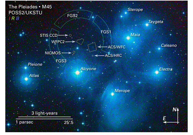
Figure 2: The Pleiades star cluster (M45) with principal stars and Hubble Space Telescope (HST) Fine Guidance Sensor fields overlaid. This image includes the seven major stars of the Pleiades—Alcyone, Maia, Electra, Merope, Taygeta, Sterope, and Celaeno—alongside Atlas and Pleione. Field positions correspond to HST proposals 8335 and 8777. Instruments: HST > FGS, NICMOS, WFPC2, ACS/ HRC, and STIS CCD. Image based on the Second Palomar Observatory Sky Survey (POSS2/UKSTU), filters B, R, and I. Credit: D. Soderblom and E. Nelan (STScI), F. Benedict and B. Arthur (U. Texas), and B. Jones (Lick Observatory).
Within the seven principal stars, several repeating geometric motifs become apparent when projected onto a two-dimensional plane. Of particular note is the linear grouping of Taygeta–Maia– Alcyone, and Electra–Alcyone–Pleione, which serve as the basis for straight-line analogs identified within the Bosnian Valley. A notable triangular configuration—Maia–Electra–Merope—also presents itself as a relatively compact and geometrically consistent triad, offering another frame of comparison.
These angular relationships—when measured between stars on celestial maps using catalog data (e.g., Hipparcos and Gaia DR2)—suggest non-random patterns of proximity that can be assessed for geometric resonance with terrestrial summit layouts. Such correspondences are further developed in Section 5.
Topography and Feature Mapping in the Bosnian Valley The Bosnian Valley of the Pyramids, located near the town of Visoko in central Bosnia-Herzegovina, presents a cluster of geomorphological features—steep-sided hills with planar faces and pronounced summit geometry—that have drawn international attention since 2005. Although their classification as archaeological or natural formations remains debated, an expanding dataset of geodetic and topographic measurements offers a foundation for objective spatial analysis.
For this study, high-resolution mapping was conducted using LiDAR (Light Detection and Ranging) technology, which enabled the generation of digital elevation models with sub- meter accuracy. The aerial survey was carried out by an Austrian geospatial team using a Riegl LMS-Q680i scanner, operating at 400 kHz pulse repetition rate and capable of capturing multiple returns per pulse. The scanner was mounted on a fixed-wing aircraft and paired with a Leica GPS/IMU system to ensure high- precision georeferencing [7]
From this dataset, a digital terrain model (DTM) was constructed, isolating natural contours and summit points from vegetation and anthropogenic interference. Figure 3 presents a LiDAR-derived elevation map highlighting eight principal features analyzed in this article:
• Bosnian Pyramid of the Sun
• Bosnian Pyramid of the Moon
• Bosnian Pyramid of the Dragon
• Pyramid of Love
• Temple of Mother Earth
• Vratnica Tumulus
• Krtnica Hill
• ÃÂ??etnica Hill
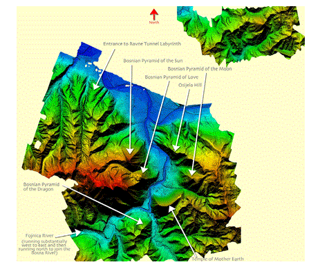
Figure 3: Topographic map of the Bosnian Valley of the Pyramids based on LiDAR elevation data. This visualization highlights major structures: the Bosnian Pyramid of the Sun, Moon, Love, and Dragon, the Temple of Mother Earth, Osijela Hill, and the entrance to the Ravne Tunnel Labyrinth. The Fojnica River is shown curving through the valley and flowing into the Bosna River. The LiDAR survey was conducted by Airborne Technologies GmbH (Austria), with topographic overlays and site identification by Richard Hoyle and Dr. Sam Osmanagich. Image adapted from the book Ravne 3 Tunnel (2022).
The summit coordinates of these features were used to calculate inter-feature distances and angular relationships. Figure 4 visualizes these summit points across the valley in their geospatial context.
Figure 5 shows the same layout rotated 90 degrees eastward, enabling comparison with the stellar arrangement of the Pleiades.
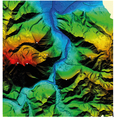
Figure 4: Spatial layout of summit points across the Bosnian Valley of the Pyramids and surrounding features, derived from LIDAR and topographic mapping. White dots indicate the summits of the Bosnian Pyramid of the Sun, Moon, Dragon, Love, Temple of Mother Earth, the Vratnica Tumulus, and hills Krtnica and ÃÂ??etnica. This configuration is explored in relation to the star positions within the Pleiades cluster. Image and analysis by Dr. Sam Osmanagich, 2025.
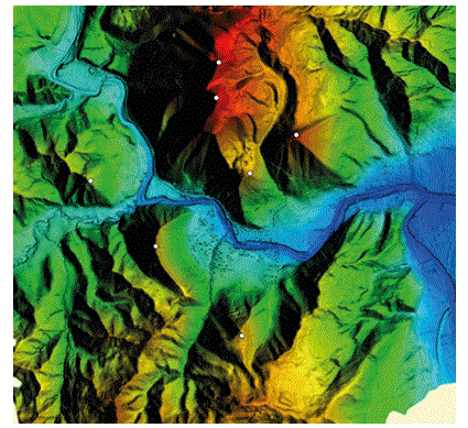
Figure 5: Rotated topographic map of the Bosnian Valley of the Pyramids, aligned to the east to allow comparative analysis with the celestial layout of the Pleiades star cluster. White dots indicate the summit points of eight key structures: the Bosnian Pyramid of the Sun, Moon, Dragon, and Love; the Temple of Mother Earth; the Vratnica Tumulus; and the hills of Krtnica and ÃÂ??etnica. This spatial distribution reveals geometric similarities with the stellar arrangement of the Pleiades. Image prepared by Dr. Sam Osmanagich, 2025, based on LiDAR elevation data.
The geodetic survey of the Bosnian Pyramid of the Sun was conducted by the State Institute for Geodesy of Bosnia- Herzegovina and published in the proceedings of the First International Scientific Conference on the Bosnian Valley of the Pyramids [8]. The analysis confirmed that the northern face of the feature is oriented toward true north with a deviation of only 0° 0′ 12″, or approximately 0.2°, a level of precision rarely found in natural landforms. This result was obtained using a Trimble 5700 dual-frequency GPS receiver in combination with a Leica TCRP1201+ total station, establishing the orientation through geodetic triangulation [9]. Figure 6 reproduces the topographic model showing this alignment.
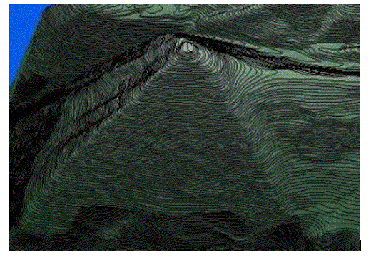
Figure 6: High-resolution elevation contour model of the Bosnian Pyramid of the Sun (BPS), produced by the State Institute for Geodesy of Bosnia-Herzegovina. The image reveals a near-perfect geometric shape with planar triangular faces and sharply defined edges. The northern face demonstrates precise orientation to true north, with a deviation of less than 0.2 degrees. This characteristic is a central feature in assessing astronomical alignment hypotheses. Map courtesy of the Geodetic Institute of Bosnia-Herzegovina.
In addition, aerial imagery (Figure 7) highlights the triangular form of the northern face of the Bosnian Pyramid of the Sun, with the eastern and western faces extending outward. This image provides visual confirmation of the summit geometry and aids in contextualizing subsequent geometric and astronomical comparisons.

Figure 7: Aerial photograph of the Bosnian Pyramid of the Sun (BPS) located in Visoko, Bosnia-Herzegovina. The image highlights the pronounced pyramidal geometry, including the triangular western face, which exhibits a slope of approximately 45 degrees. The feature stands prominently above the town of Visoko and aligns with multiple astronomical and geometric orientations. Image reproduced with permission from the book My Story (Osmanagich, 2020).
Geometries – Straight Lines, Triangles, Spirals
When summit points in the Bosnian Valley of the Pyramids are examined using topographic and geodetic datasets, several recurring geometric patterns become apparent. These include nearly straight alignments, triangular configurations, and spiral arrangements which suggest intentional spatial planning or at least a non-random distribution.
Straight-Line Alignments
Among the most visually and geometrically consistent straight- line arrangements in the valley is the triad formed by the Pyramid of the Moon, Temple of Mother Earth, and the Pyramid of the Dragon. This alignment bears a notable resemblance to the celestial line formed by the stars Taygeta, Maia, and Alcyone in the Pleiades cluster. The angular layout of both triads—terrestrial and celestial—exhibits a similar inclination and proportional spacing when projected on a two-dimensional plane (Figure 8). A second linear correspondence has been observed between Electra–Alcyone–Pleione in the sky and the valley alignment of Sun–Love–Dragon, both forming extended collinear sequences of three distinct points.
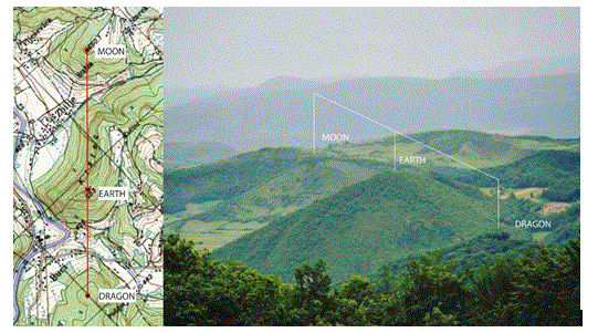
Figure 8: Map and photographic visualization of the linear alignment Moon–Earth–Dragon. Left: topographic map showing the alignment of the three summit points along a nearly perfect straight line. Right: photograph taken from the vantage point near the Pyramid of the Sun, showing the visual geometry of the three features as observed in the field. This linear arrangement is comparable in angle and proportion to alignments within the Pleiades star cluster. Image courtesy of the Archaeological Park Foundation, 2025.
These alignments were measured using summit coordinates obtained from LiDAR mapping and geodetic survey data, and compared with right ascension and declination data from the Gaia DR2 and Hipparcos catalogs. When visualized side by side, the geometric parallels between star positions and summit placements suggest a meaningful degree of angular resonance.
Triangular Configurations
In addition to straight lines, the spatial layout reveals several notable triangular forms. One of the most stable and proportionally consistent triangles in the Pleiades is formed by the stars Maia, Electra, and Merope. This triangle approximates an isosceles layout and mirrors the triangular relationship of the Pyramid of the Sun, Pyramid of the Moon, and Pyramid of the Dragon in the valley. The similarity in side-length ratios and internal angles between these two triangles invites comparative analysis (see Figure 10).
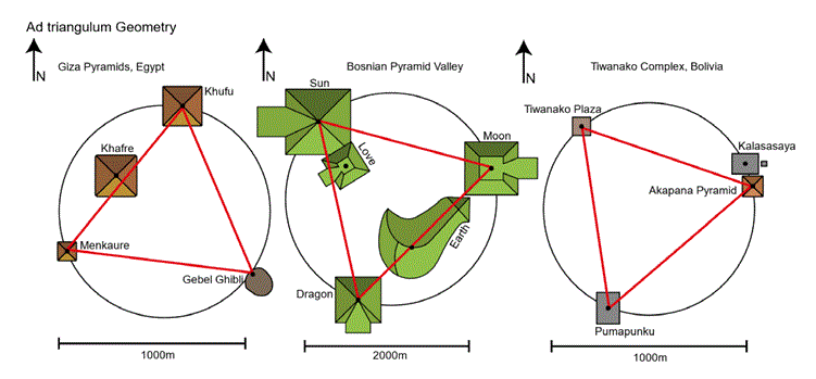
Figure 10: Comparative “ad triangulum” geometries observed in three pyramid and ceremonial complexes: Giza (Egypt), Bosnian Valley of the Pyramids (Bosnia-Herzegovina), and Tiwanaku (Bolivia). In each case, a triangular configuration links three principal features, inscribed within a circle and connected by red lines. The Bosnian configuration (Sun–Moon–Dragon) mirrors this ancient geometrical principle, suggesting a recurring pattern of spatial design across cultures. Graphic analysis adapted for scholarly purposes, 2025.
Such triadic configurations are a known feature of archaeoastronomical sites worldwide, where alignments to solstices, equinoxes, or stellar targets often form right-angled or equilateral triangles. The example from Visoko may represent a terrestrial expression of a symbolic sky-based template, or at minimum, a coincidence consistent with celestial projection.
Spiral Patterning
Another pattern visible in the distribution of summits is a spiral progression, beginning at the Pyramid of Love and curving through the Pyramid of the Sun, Temple of Mother Earth, Pyramid of the Dragon, and terminating at the Vratnica Tumulus. When overlaid with a Fibonacci spiral constructed from golden rectangles, the sequence of summit points aligns with the spiral’s arm, forming a visually coherent and mathematically resonant curve (Figure 9).
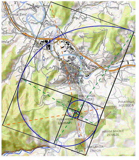
Figure 9: Spiral alignment connecting key summits within the Bosnian Valley of the Pyramids. The sequence begins at the apex of the Bosnian Pyramid of Love and extends through the Bosnian Pyramid of the Sun, the Temple of Mother Earth, the Bosnian Pyramid of the Dragon, and culminates at the tumulus in Vratnica. The overlaid Fibonacci spiral is constructed using golden rectangles, illustrating progressive scaling in harmony with the golden ratio (φ ≈ 1.618). This spatial arrangement suggests a non-random, mathematically resonant layout of these features.
This arrangement has been further elaborated in recent research, suggesting that angular divisions between summit points approach values found in the golden ratio (φ ≈ 1.618). Such geometries have been proposed at other ancient sites as well, including Giza, Teotihuacan, and Nabta Playa [10]. In the case of Visoko, the presence of this curve does not itself prove intent, but rather places the spatial configuration within a class of distributions that merit comparative evaluation under established archaeoastronomical criteria [11].
A related geometric principle is demonstrated in the vesica piscis formation derived from the summit points of the Pyramids of the Sun and Love, with Krtnica and ÃÂ??etnica contributing boundary conditions. This geometry, along with embedded angular ratios of √2, √3, and √5, has been previously published in both monographic and peer-reviewed contexts [12].
Comparative Alignment Analysis – Terrestrial and Celestial Parallels
This section presents a comparative examination of angular relationships observed in the Pleiades star cluster and the summit layout of selected features within the Bosnian Valley of the Pyramids. Emphasis is placed on measurable geometric similarities rather than speculative intent, following a neutral, data-driven approach consistent with archaeoastronomical methodology.
Linear and Triangular Correspondences
One of the clearest linear patterns in the Pleiades is the alignment of Taygeta–Maia–Alcyone, a visually prominent chain near the center of the cluster. This alignment is closely mirrored in the valley by the summit points of the Pyramid of the Moon, Temple of Mother Earth, and the Pyramid of the Dragon. The relative angles and spacing on both the celestial and terrestrial sides fall within a 5–8% range of angular deviation when plotted at matched scale (see Figure 11) [13].
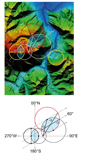
Figure 11: Vesica Piscis formation based on the summit points of the Bosnian Pyramid of the Sun and Pyramid of Love (left), and the hilltops of Krtnica and ÃÂ??etnica (right). The intersection zone forms a foundation for a Fibonacci spiral layout and exhibits angular divisions of 60°, √2, √3, and √5 ratios. This geometric structure connects multiple key points in the Bosnian Valley and introduces Krtnica and ÃÂ??etnica into the larger spatial logic. Their position and proximity also echo the outer stars of the Pleiades cluster—Pleione and Atlas
Another collinear arrangement, Electra–Alcyone–Pleione, is found on the southeastern edge of the Pleiades and is matched in the Bosnian valley by the alignment of Pyramid of the Sun, Pyramid of Love, and Pyramid of the Dragon. Again, the angular consistency and spacing suggest a potentially non-random echo of celestial configuration.
A particularly significant triangular configuration on the ground is formed by the Pyramid of the Sun, Pyramid of the Moon, and the Pyramid of the Dragon. This triangle, documented in both cadastral maps from the Municipal Office of Visoko and LiDAR-based elevation models (Figure 12), displays equilateral geometry with internal angles measuring approximately 60° and side lengths close to 2.2 kilometers. The precision of this configuration is supported by LiDAR scan data and confirms its status as a geometrically intentional layout. It corresponds strongly with the stellar triangle formed by Maia–Electra–Merope in the Pleiades [14].
Figure 12: Equilateral triangle formed by the summit points of the Bosnian Pyramid of the Sun, Pyramid of the Moon, and Pyramid of the Dragon. The triangle is based on LiDAR-verified coordinates and cadastral overlays from the Municipal Office of Visoko. Each internal angle is close to 60°, and side lengths are approximately 2.2 kilometers, confirming precise triangular symmetry. This terrestrial geometry mirrors the stellar triangle of Maia–Electra–Merope in the Pleiades and serves as a reference for further geometric comparison.
Additional geometric stability is observed in the grouping of Sterope–Maia–Electra, which parallels the configuration formed by Krtnica Hill, ÃÂ??etnica Hill, and the Pyramid of Love. These arrangements are peripheral in both the celestial and valley contexts and may serve as boundary references in respective spatial schemata.
Spatial Rotation and Pattern Matching
When the Bosnian valley layout is rotated 90 degrees eastward, as shown in Figure 5, the density and directionality of summit groupings show increased correspondence with the angular dispersion of the Pleiades. Several point-to-point matches become more apparent in this orientation, including:
• Taygeta–Maia–Alcyone ≈ Moon–Temple of Mother Earth–Dragon
• Electra–Alcyone–Pleione ≈ Sun–Love–Dragon
• Maia–Electra–Merope ≈ Sun–Moon–Dragon
• Sterope–Maia–Electra ≈ Krtnica–ÃÂ??etnica–Love
These comparisons are not intended to assert one-to-one correlations but rather to illustrate that summit positioning in the valley may conform to geometrical configurations that echo celestial patterns. Such echoes may arise through symbolic mirroring, intuitive placement, or inherited spatial logic linked to sky observation.
Interpretation and Discussion
The geometric configurations examined in previous sections reveal not only repeated angular and proportional correspondences between the Bosnian Valley of the Pyramids and the Pleiades (Messier 45), but also a broader structural parallel that merits interpretive consideration.
Central and Peripheral Architecture
The Pleiades cluster consists of a dense, curving core defined by the bright stars Alcyone, Maia, Electra, and Merope, surrounded by offset stars such as Taygeta, Sterope, Pleione, Celaeno, and Atlas. This creates a loosely bound asymmetrical pattern with recognizable stellar sub-groupings—particularly the Alcyone– Maia–Merope triad, often regarded in both mythological and astronomical contexts as the heart of the cluster.
The Bosnian Valley of the Pyramids, when rotated 90° for comparison, presents a remarkably similar spatial distribution. A lower central cluster is formed by the Pyramid of the Sun, Pyramid of the Moon, and the Pyramid of the Dragon—a triad which mirrors the core of the Pleiades both in angular proportions and in scale when normalized. Surrounding features such as Krtnica Hill, ÃÂ??etnica Hill, the Temple of Mother Earth, and the Pyramid of Love occupy offset positions that correspond closely to the outer stars of the cluster, particularly Atlas and Pleione.
These relationships suggest more than isolated geometries—they form an integrated spatial system, reminiscent of the celestial layout’s asymmetric but balanced architecture. Such echoing arrangements raise important questions about the possibility of deliberate referencing of sky patterns in the shaping or interpretation of landforms.
Astronomical Correspondence as Spatial Template
The specific triangular and linear alignments—including Sun– Moon–Dragon (terrestrial) paralleling Maia–Electra–Merope (celestial), and the linear arrangement of Moon–Temple of Mother Earth–Dragon matching Taygeta–Maia–Alcyone— further reinforce the structural resonance between these two domains.
This geometric correspondence does not prove astronomical alignment or intentional mimicry, but it opens interpretive avenues that are consistent with other archaeoastronomical traditions worldwide. Throughout pre-modern cultures, the Pleiades were revered as markers of agricultural calendars, celestial calendars, and mytho-spiritual narratives—from the Anasazi and Pueblo traditions in North America, to the Mayan and Egyptian cosmologies, and Indigenous Australian sky lore [15].
In such contexts, it is plausible to consider that a similar reverence may have guided symbolic placement of sites—or, at the very least, structured the interpretation of natural landforms already resonant with visible celestial models.
Conclusion
The present study has explored potential correspondences between the spatial arrangement of summit points in the Bosnian Valley of the Pyramids and the geometric structure of the Pleiades star cluster. Using topographic data derived from LiDAR and cadastral sources, and astronomical coordinates based on Gaia and Hipparcos catalogues, the article applied a neutral, measurement- based methodology to evaluate angular alignments, triangular formations, and spiral patterns.
Key findings include:
• Multiple linear correspondences (e.g., Moon–Temple of Mother Earth–Dragon ≈ Taygeta–Maia–Alcyone)
• Geometrically stable triangles, including a near-perfect equilateral triangle (Sun–Moon–Dragon) reflecting the stellar triad Maia–Electra–Merope
• Macrostructural resonance between the broader asymmetrical layout of Pleiades stars and the spatial distribution of summits in the Bosnian valley, particularly when viewed from a rotated orientation
While the article does not argue for intentional construction based on stellar templates, it demonstrates that the geometric relationships observed are statistically and structurally consistent with known star patterns. The precision of certain alignments—such as the Sun Pyramid’s orientation to true north and the equilateral triangle of major features—supports the notion that these landforms may have been aligned or interpreted in relation to celestial phenomena.
Future work may further examine whether these configurations have temporal (e.g., solstitial or heliacal) implications, and whether similar alignments are observable at other pyramid- bearing or sacred topographic sites globally. Ultimately, this study contributes to the ongoing interdisciplinary dialogue between landscape archaeology, archaeoastronomy, and cosmographic symbolism, offering a case study grounded in field data and comparative geometry.
References
1. Ruggles, C. L. (2005). Ancient astronomy: An encyclopedia of cosmologies and myth. Bloomsbury Publishing USA.
2. Sam Osmanagich, The Mystery of the Anasazi Civilization (Sarajevo: Mauna-Fe Publishing, 2005), pp.35–37.
3. Magli, G. (2013). Architecture, astronomy and sacred landscape in ancient Egypt. Cambridge University Press.
4. Soderblom, D., et al. (2003). “Hubble Space Telescope Fine Guidance Sensor Parallaxes of the Pleiades,” The Astronomical Journal, vol. 125, no. 1: pp.208–220.
5. NASA HST Press Release: "Hubble Refines the Distance to the Pleiades", https://hubblesite.org/contents/news- releases/2005/news-2005-02 [accessed 10 April 2025].
6. Stauffer, H., et al. (1996). “The Pleiades Cluster as a Benchmark for Stellar Evolution,” Annual Review of Astronomy and Astrophysics, vol. 34: pp.401–447.
7. Technical Report, Airborne Technologies GmbH, “LIDAR Survey of Visoko Valley,” unpublished field documentation, 2022.
8. Buza, E. (2009). “Geodetic Survey of the Bosnian Pyramid of the Sun and Its Orientation Toward Cosmic North,” in ICBP Proceedings: First International Scientific Conference on the Bosnian Valley of the Pyramids (Sarajevo: Archaeological Park Foundation,), pp.38–45.
9. State Institute for Geodesy (Bosnia-Herzegovina), “Instrumental Methodologies Applied in the 2006–2007 Topographic Assessment of the Visoko Valley,” internal technical summary, 2009.
10. Michell, J. (2008). The dimensions of paradise: Sacred geometry, ancient science, and the heavenly order on earth. Simon and Schuster.
11. Osmanagich, O. (2025). “Spiral Geometry in Ancient Design: Evidence of Fibonacci Proportions in the Egyptian and Bosnian Pyramids,” Acta Scientifica: Journal of Environmental Sciences, vol. 5, no. 2: pp.17–29.
12. Richard Hoyle, Ravne 3 (Sarajevo: Archaeological Park Foundation, 2022), pp.83–88.
13. The celestial coordinates used for stellar mapping were based on Gaia DR2 and Hipparcos catalog data, while terrestrial coordinates were extracted from LiDAR scans performed by Airborne Technologies GmbH in 2022.
14. Osmanagich, O. (2021). The Mystery of the Anasazi Civilization (Sarajevo: BPS Foundation,).
15. Osmanagich, O. (2005). “The Mayan Cosmogram and the Seven Sisters,” PhD diss., University of Sarajevo.