

World Journal of Forest Research(WJFR)
ISSN: 2994-5569 | DOI: 10.33140/WJFR


Research Article - (2026) Volume 5, Issue 2
Application of Artificial Intelligence Technologies for Real-Time Monitoring of Poaching Activities in Gashaka-Gumti National Park, Taraba State, Nigeria
Received Date: Sep 02, 2026 / Accepted Date: Oct 07, 2026 / Published Date: Nov 13, 2026
Copyright: ©2026 Riki, J. T. B, et al. This is an open-access article distributed under the terms of the Creative Commons Attribution License, which permits unrestricted use, distribution, and reproduction in any medium, provided the original author and source are credited.
Citation: Maiguru, A. A., Riki, J. T. B., Zaku, S., Ishaku, R. (2026). Application of Artificial Intelligence Technologies for Real-Time Monitoring of Poaching Activities in Gashaka-Gumti National Park, Taraba State, Nigeria. World J Forest Res, 5(2), 01-10.
Abstract
This study assessed the application of artificial intelligence (AI) technologies for real-time monitoring of poaching activities in Gashaka-Gumti National Park, Taraba State, Nigeria. The study was conducted to examine the potential of AI-enabled monitoring devices to detect wildlife and identify suspected poaching activities within selected locations of the park. Three locations, namely Mayo-Selbe, Forest Research, and Filinga Range, were selected for monitoring over a period of 72 hours using TrailGuard and AmbushCam devices installed along footpaths and vehicle tracks. The results show that Mayo-Selbe accounted for 50% of the recorded wildlife detections, while Forest Research and Filinga Range each accounted for 25%. Four wildlife species were identified: red-flanked duiker (Cephalophus rufilatus), harnessed bushbuck (Tragelaphus scriptus), Nigeria-Cameroon chimpanzee (Pan troglodytes ellioti), and olive baboon (Papio anubis). Regarding suspected poaching activities, Mayo-Selbe accounted for 60% of the recorded observations, Forest Research accounted for 40%, while no suspected poaching activity was recorded at Filinga Range during the monitoring period. These findings indicate that AI-enabled monitoring devices can support wildlife detection and help identify locations requiring greater anti-poaching surveillance. The study recommends extending monitoring across different seasons, integrating AI devices with GPS, GIS, acoustic sensors, and ranger communication systems, and strengthening collaboration between park authorities and surrounding communities. Such measures could improve surveillance efficiency, support evidence-based conservation decisions, and contribute to the sustainable management of wildlife resources in Gashaka-Gumti National Park.
Keywords
Artificial Intelligence, Poaching, Real-Time Monitoring, Trailguard, Ambushcam, Wildlife Conservation, Gashaka-Gumti National ParkIntroduction
One of the biggest risks to the preservation of wildlife and biodiversity in Nigeria's national parks is poaching. Wild animals and their body parts are illegally hunted, captured, killed, or traded. Poaching has the potential to lower wildlife populations, jeopardise endangered species, upset ecological balance, threaten ecotourism, and jeopardise the sustainable management of protected areas. Conventional anti-poaching techniques mostly rely on camera traps, informants, ranger surveillance, foot patrols, and sporadic field inspections [1]. These techniques are still crucial, but they may be constrained by a lack of staff, a lack of money, challenging terrain, inadequate communication networks, and the extent of protected areas.
Artificial intelligence (AI) offers opportunities to improve wildlife protection through real-time monitoring, automated detection, predictive analysis, and rapid communication of suspected poaching incidents. When integrated with remote sensing, camera traps, acoustic sensors, drones, GPS, and geographic information systems (GIS), AI can help park authorities identify suspicious activities and deploy rangers more efficiently [2]. One of Nigeria's most significant protected areas, Gashaka-Gumti National Park is situated in the northeastern states of Taraba and Adamawa. Numerous wildlife species can be found in the park's different ecosystems, which include grasslands, woods, montane forests, and riverine habitats. It is an important region for scientific research, ecotourism, and wildlife protection due to its biodiversity and ecological significance [3]. Despite its significance for conservation, the park's proper protection necessitates ongoing observation of both human activity and animals. Unauthorised access, habitat degradation, illegal hunting, wildlife trafficking, and other human pressures can endanger wildlife populations and compromise conservation goals. Routine surveillance may be complicated by the park's large size, rough terrain, dense foliage in some areas, and possibly challenging access to isolated regions [4].
In Nigeria, the application of these technologies could strengthen the protection of wildlife in national parks such as Gashaka-Gumti, Cross River, Kainji Lake, Kamuku, Okomu, and Chad Basin National Parks. However, their effectiveness would depend on reliable infrastructure, trained personnel, appropriate funding, data quality, and cooperation with local communities.
The Gashaka-Gumti (GGNP), forestland resources is also confronted with increasing illegal exploitation in the semi-arid Northesternern Nigeria. Government and relevant stakeholders have been struggling with finding possible measures to curtail the illegal exploitation of its scarce resources [5]. Fortunately, few developed artificial intelligence (AI) technologies such as Trailguard and Ambushcams, openstreet map, unmannd aerial vehicles-UAVs (drones), satellite imagery, global forest watch and on-the-ground sensors have among others, been employed to remotely monitor forests with huge successes [6]. Forest security personnel are faced with scanty monitoring resources and vast tracts of difficult terrains to protect, amidst continued struggle in stopping illegal logging and poaching activities at the GGNP. Thus, being effective forest manager is often an impossible task without the help of AI technologies. This research will go a long way in documenting poaching index which will be valuable forest policy making, by-law makers and for reference purpose by student and forest managers in Taraba State.
Materials and Methods
Description of Study Area
foot of the Mambilla Plateau and covers a land area of about 6,411 km2. It lies between latitude 6º55’N and 8º05’N and longitude 11o13’ to 12º11’E. The park was originally gazetted as Gumti, Gashaka and Serti Game sanctuaries by the defunct Northeast Government in the 1970's. The three game sanctuaries were merged and upgraded to a National park by the Nigeria National Park Decree of 26th August 1991 which was repealed by Decree 46 of 1999. Gashaka –Gumti National Park is a vast land of spectacular wilderness (6,000 km2) in the southeast corner of Taraba State, adjoining the Mambilla Plateau (Figure 1 and Figure 2). The Park, like any other Park, was established as a protected area for the purpose of nature conservation, recreation, ecotourism, scientific and medical research, and to promote art, craft and other cultural values of the indigenous people of the immediate environment. The Park is an outstanding tourist landmark in Taraba State. Its unique position is underlined by the fact that it is not only the largest of all the eight national parks in the country, but it is the most diverse in terms of species in the whole of West Africa, harboring such rare animals like the colobus monkey and warthogs, including buffalo, roam antelope, chimpanzee, hippopotamus, hyena, giant forest hog, lion and leopard [7].
It is home to some highly endangered species of wildlife. Threatened with extinction elsewhere, chimpazees are truly at home at Gashaka Gumti park; they are safe, secured, relaxed and confident. Its vast expanse of land contains river valleys and peaks that are suitable to holiday makers. The park is crisscrossed by many rivers (notably rivers Kam, Gashaka, Yim and Gam-Gam) which, among other ecological functions, act as reservoirs of diversity. Visitors to this secluded region will find no roads here, but only a small number of footpaths snaking through the wooded mountains in the direction of Republic of Cameroon. Visitors to the Gashaka-Gumti National Park would be able to take pleasure in the flourishing forests, the extensive sweeping grasslands, the fresh highland plateaus, the Rocky Mountains, rich wildlife and the captivating ethnic cultures [8].
The climate of the park ranges from tropical to humid at different times of the year. The ethnic groups in the area are Jibu, Dakka, Ndoro, Tigun, Gbaya, Tiv, Mambilla, Kaka and Fulani in the southern part of the park, while in the northern part or Toungo sector are the Chamba, Kutim Potopore, Fulani, Dakka, Nyamnyam and Kona. The major occupations of the enclave communities are farming, livestock husbandry, vocational jobs, civil service with few hunters and fishermen. They engage in subsistence farming and crops cultivated include maize, groundnut, millet, guinea corn, beans, soya beans, rice, yams, sugar cane, and cassava [8].

Source: Oruonye [8].
Figure 1: Map of Gashaka

Source: Oruonye [8].
Figure 2: Gashaka-Gumti National Park
Sampling Procedure
Three (3) locations (Mayo-Selbe-7 º42’N & 11º33’E, Forest Research-7 º41’N & 11º32’E and Filinga ranges-7 º43’N & 11º33’E) were strategically selected for study within the National Park for seventy-two (72) hours. On each location a tree with straight bole of 3 metres height were sampled for installation of TrailGuard and AmbushCams on foot and truck paths to sense and monitor eventual noise, sound, motion images at the GGNP.
Equipments

Plate 1: Images of AmbushCam and TrailGuard
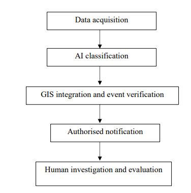
AI monitoring framework
Data Analysis
The data collected from poaching activities were subjected to analysis of variance (ANOVA) in a completely randomised design (CRD). The sample means were compared using standard errors (SE) and were separated using Least Significant Difference (LSD).
Result and Discussions
Animal Detection
Table 1 shows that four (4) wild fauna species were sighted in this study. Cephalophus rufilatus and Tragelaphus scriptus were sighted in Mayo-Selbe accounting for 50% of the sampled animal detected, Pan troglodytes ellioti was sighted in Forest Research and Papio anubis in Filinga range with 25% each. The Mayo-Selbe range area was home to the highest number of wild vertebrate species often sighted by the camaras during the study. Free-ranging animals do not respect boundaries, so it is essential to protect or manage designated habitats that are conserved to serve as wildlife species' natural habitat in a way that maximises the resources required by the local wild fauna or flora species [9]. If this expectation is not met, the flora species that many wildlife species depend on for food and cover will be initially depleted. This will negatively impact the stability and niche of the wildlife in the habitat, leading the species to migrate outside in search of essential resources, particularly food [10]. The Mayo-Selbe range area appears to have more food, which led to more sighted animals. These species were likely concentrated in particular range areas with more of their food and other natural habitat requirements within the park. The same pattern of animal availability were also recorded by Ikpa [10].
|
Location |
Frequency |
Percentage |
|
Mayo-Selbe |
50 |
50 |
|
Forest Research |
25 |
25 |
|
Filinga ranges |
25 |
25 |
|
Total |
100 |
100 |
|
Source: Fieldwork, (2025). |
||
Table 1: Animal Detection at Gashaka-Gumti National Park
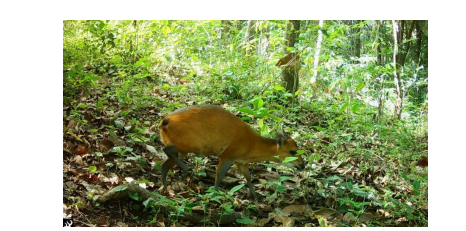
Plate 1: Image of Red-flanked duiker (Cephalophus rufilatus)
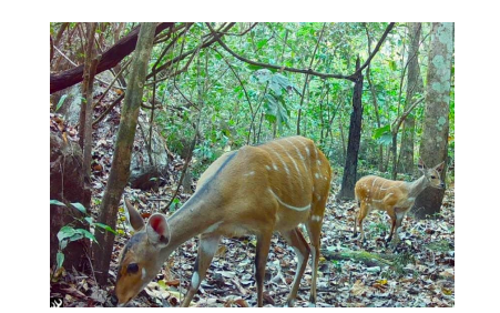
Plate 2: Harnessed bushbuck (Tragelaphus scriptus)

Plate 3: Chimpanzee (Pan troglodytes ellioti)
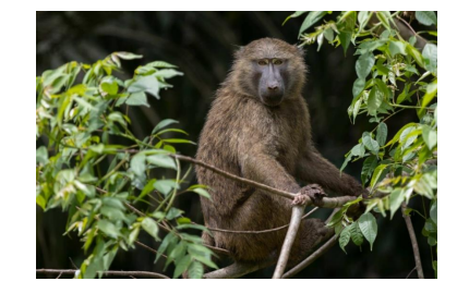
Plate 4: Olive baboon (Papio anubis)
Poaching Activities at Gashaka-Gumti National Park
Among the three (3) selected locations for this study (Mayo-Selbe, Kwano, Forest Research and Filinga ranges) as presented in Table 2. Plate 4, 5 and 6 were sighted in Mayo-Selbe accounting for 60% and plate 7 & 8 accounted for 40% poachers were also sighted in Forest Research camp while the Filinga ranges recorded nothing during the three (3) days for this study. This may be due to the presence of ranger camp around the range especially international organization camp like Africa Nature Investors (ANI) Foundation. The high numbers of poachers sighted at Mayo-Selbe could be due to the availability of their foods around their area compared to other camps. This is in consonance with the work of Usman et al., (2022), who reported poaching as one of the major human activities on the environment that influencing loss of biodiversity in Gashaka Gumti National Park, similarly, Poaching was recorded as one of the highest affecting the health of Gashaka Gumti National Park using SWOT Analysis ( Madaki et al., 2020).
|
Location |
Frequency |
Percentage (%) |
|
Mayo-Selbe |
60 |
60 |
|
Forest Research |
40 |
40 |
|
Filinga range |
- |
- |
|
Total |
100 |
100 |
|
Source: Fieldwork, (2025). |
||
Table 2: Poaching Activities at Gashaka-Gumti National Park

Plate 5: Image of poacher
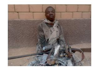
Plate 6: Image of poacher
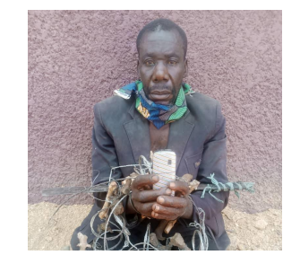
Plate 7: Image of poacher

Plate 8: Image of poacher
Conclusion
The study examined the application of artificial intelligence technologies for real-time monitoring of poaching activities in Gashaka-Gumti National Park, Taraba State, Nigeria. The findings demonstrate the potential usefulness of AI-enabled monitoring devices, particularly TrailGuard and AmbushCam, in detecting wildlife and identifying locations where suspected poaching activities occur. The identification of four wildlife species confirms the importance of the selected locations for wildlife monitoring and conservation.
Mayo-Selbe recorded the highest proportion of wildlife detections (50%) and suspected poaching observations (60%), followed by Forest Research, which accounted for 25% of wildlife detections and 40% of suspected poaching observations. No suspected poaching activity was recorded at Filinga Range during the 72-hour monitoring period. These differences suggest that monitoring priorities may need to vary across locations. However, the absence of recorded activity at Filinga Range does not necessarily indicate that poaching does not occur there, as detection depends on monitoring duration, device placement, animal and human movement, and the performance of the equipment.
The study therefore concludes that AI-assisted monitoring can complement conventional anti-poaching measures by improving the detection of wildlife and suspected illegal activities, supporting timely ranger responses, and providing information for conservation planning. Nevertheless, the limited duration and geographical coverage of the study mean that the results should be interpreted as preliminary findings rather than a comprehensive assessment of poaching across the entire national park.
It is recommended that the National Park Service and other relevant conservation stakeholders expand AI-based surveillance to additional locations and conduct monitoring over longer periods covering different seasons. Ultimately, the strategic application of AI technologies, combined with effective law enforcement and community-based conservation, could strengthen anti- poaching operations, improve wildlife protection, and promote the sustainable management of Gashaka-Gumti National Park and other protected areas in Nigeria.
References
- Imarhiagbe, O., Egboduku, W. O., & Nwankwo, B. J. (2020). A review of the biodiversity conservation status of Nigeria.
- Ojija, F., Ogwu, M. C., Ally, J., John, J. P., Stephano, A., Felix, N., & Tekka, R. (2025). Artificial intelligence-driven solutions for mitigating human–wildlife conflict in biodiversity hotspots. Science Progress, 108(4), 00368504251394584.
- Adeonipekun, P. A., Adeleye, M. A., Oyebanji, O. O., & Haberle, S. G. (2025). Millennia of climate and human influence on Gashaka-Gumti montane landscape, West Africa: Implications for biodiversity conservation and management. Quaternary International, 730, 109775.
- Stephenson, P. J., Londoño-Murcia, M. C., Borges, P. A., Claassens, L., Frisch-Nwakanma, H., Ling, N., ... & Fumagalli, L. (2022). Measuring the impact of conservation: the growing importance of monitoring fauna, flora and funga. Diversity, 14(10), 824.
- Pimm, S. L., Alibhai, S., Bergl, R., Dehgan, A., Giri, C., Jewell, Z., ... & Loarie, S. (2015). Emerging technologies to conserve biodiversity. Trends in ecology & evolution, 30(11), 685-696.
- Cheung, L., Mason, J., Parker-Forney, M. (2015). Perimeter Defense: 4 technologies for detecting and preventing illegal logging. A world Resource Institute (WRI) Webinar Meeting held from September, 16-18th, 2015 in Conjunction with California Academy of Science’s Conservation Drones Summit at San Francisco, California, USA.
- Ayodele, A. I. (2001). Management of tourism potentials in Nigerian national parks. Cultural and Ecotourism Development in Nigeria: The role of the three tiers of Government and the Private Sector. Hope Publication, Ibadan, Oyo State pNigeria, 136-143.
- Oruonye, E. D., Ahmed, M. Y., Garba, A. H., & Danjuma,R. J. (2017). An assessment of the ecotourism potential of Gashaka Gumti National Park in Nigeria. Asian Res. J. Arts Soc. Sci, 3, 1-11.
- Eken, G., Bennun, L., Brooks, T. M., Darwall, W., Fishpool,L. D., Foster, M., ... & Tordoff, A. (2004). Key biodiversity areas as site conservation targets. BioScience, 54(12), 1110-1118.
- Ikpa, T. F., Dagba, B. I., & Akusu, J. M. (2011). Wild vertebrate pests activities on agricultural crops at Gashaka Gumti National Park, Nigeria. Global Journal of Agricultural Sciences, 10(1), 33-37.