
Open Access Journal of Applied Science and Technology(OAJAST)
ISSN: 2993-5377 | DOI: 10.33140/OAJAST
Impact Factor: 1.08


Research Article - (2024) Volume 2, Issue 2
Geopolitical and Environmental Aspects of the Runoff Agricultural System and the Carpet of Monasteries in the Levant in the Sixth Century CE
Received Date: Aug 15, 2024 / Accepted Date: Sep 18, 2024 / Published Date: Sep 25, 2024
Copyright: ©Â©2024 Moti Haiman. This is an open-access article distributed under the terms of the Creative Commons Attribution License, which permits unrestricted use, distribution, and reproduction in any medium, provided the original author and source are credited.
Citation: Haiman, M. (2024). Geopolitical and Environmental Aspects of the Runoff Agricultural System and the Carpet of Monasteries in the Levant in the Sixth Century CE. OA J Applied Sci Technol, 2(2), 01-15.
Abstract
This article is based on the findings of a mapping project of portions of the runoff agricultural system in the Levant in during the Byzantine period, the purpose of which was to study the resemblance between the components of that system in the desert and those in the sedentary land. These include dammed wadis, specific agricultural installations and settlement sites, among them chapels and livestock pens. The focus on agricultural installations has led to the possibility of dating the peak of the agricultural system’s functioning to the second half of the sixth century CE. Two assumptions will be put to the test: (1) that the establishment of the agricultural system overlapped the climate crisis in Europe that compromised food production in most areas of the Byzantine Empire – but not in the Levant, which for a certain period became a food supplier; (2) that the Church, as the emissary of the empire, stood at the head of the system.
Keywords
Runoff Agriculture
Introduction
This article presents an environmental, economic, and geopolitical perspective on the runoff agricultural system in the Levant during the Byzantine period, based on data collected in the framework of a mapping project of portions of that system (Figure 1). The purpose of the project was to study the resemblance of the agricultural system as it is known in the desert to those same exact components that are common in the sedentary land to the north. The project’s main fieldwork took place between 2003 and 2016, and focused on detailed mapping of the components of the agricultural system, which include dammed wadis, agricultural installations and settlement sites. In recent years, the focus has been on incorporating data from multidisciplinary environmental studies. The project’s methodology is based on the challenges of documenting all the visible features in a given area and of sorting them into original settlement groups, considering that the features in question sometimes represent a mixture of various periods [1]. The mapping was done by GPS in order to create a GIS layer of archaeological features as a basis for interdisciplinary studies.
The goal of this article is to discuss a number of prominent points that emerged during the project, among them the possibility that this extensive agricultural system fully functioned only briefly in the second half of the sixth century CE. It was found that this conclusion could be drawn based solely on the dating of the agricultural installations rather than solely on the basis of the settlements adjacent to the system, which may have existed for a longer period. Another prominent element associated
to that agricultural system is the large number and size of the winepresses and oil presses; these reflect mass production, sometimes called ‘industrial,’ of wine and oil, much beyond self- consumption. These data lead to the possibility that the rise and fall in this agricultural system might be connected to the climate crisis that struck large areas of the Byzantine Empire, but spared its southern margins, which for a time became food suppliers.
Components of the Runoff Agricultural System
The runoff agricultural system consists of a number of elements:
Dammed Wadis
These have been studied in the past in terms of their suitability to the desert, and include two prominent elements: 1. Extensive engineering of wadi basins that included filling and levelling the soil, allowing equal distribution of water to terraces and removing water surpluses in instances of flooding; 2. A network of channels to lead rainwater runoff from the slopes to the wadis, augmenting the quantity of water and allowing large-scale cultivation even in the desert [2]. This system is fundamentally different from the exploitation of slope runoff or floodwater for small agricultural areas that have been identified in the Negev in the past.
Slope Systems (Tuleilat El-‘Anab)
Heaps of stones with a diameter and height of c.1 m or strips of gravel with widths of c.1 m and a few dozen metres long, spread sometimes over a few square kilometres. Studies concluded that their purpose was to augment the flow of water or soil to the dammed wadis [2-3].
Agricultural Installations
Installations that can be associated with runoff farming include:
Square Field Towers
These were apparently guard towers or harvest storage facilities, measuring c.5×5 m and c.2 m high, with an entrance and a floor level.
Industrial Winepresses
Large winepresses with treading surfaces measuring as much as c.10×10 m, collection vats with volumes as great as c.10,000 litres and sometimes storage cells [4-6]. The large number and distribution of these installations within and outside of settlements, sometimes in clusters, attest to mass production of wine.
Industrial Oil Presses
These are also typically large, numerous, and situated, singly or in clusters, in and beyond settlement sites. They are found only in the sedentary land north of Beer Sheva [7].
Livestock Pens
The dominant element of many of these settlements, mainly in the sedentary land, are courtyards that can be identified as livestock pens, among other reasons based on the large number of cisterns adjacent to the pens, abutted in many cases by stone watering troughs.
The Head of the System and the Identity of the Population A prominent element in most of the settlement sites associated with the runoff agricultural system are rooms that can be identified as chapels and churches, This identification is based on prominent architectural elements that differ from other structures in the settlement: walls built of large, carefully dressed stones, sometimes up to 1 m long, occasional fragments of columns and, in almost all cases, scattered floor mosaic tesserae. Studies that have discussed such sites categorized them by size, calling them ‘rural towns,’ ‘monasteries,’ ‘estates’ and ‘churches,’ [8-13]. Some of these conclusions should be re-evaluated, given that at the sites whose ground plans were mapped, no matter what their size, livestock pens were found to be the dominant element and dwelling rooms were few. Despite the lack of consensus over their identification as monasteries, the preference here is to identify them as monasteries, which reflect emergency actions to produce food as agents of the empire more than a religious element, as had developed in the previous centuries.
As will be shown below, this agricultural settlement system is different in every way from the autochthonous settlements, as well as from monasteries from the previous phase, in the very transition from production for self-consumption to mass production. With regard to the population of the monasteries, studies that have discussed inscriptions in churches, chapels and on tombstones have found that these were congregations of individuals from throughout the Mediterranean basin, led by the Church [14-15]. Another possible source of the population are monastic groups already present in the Levant, for example, the monastic movements of Jerusalem and Gaza. As to the possibility that these were autochthonous populations that had converted to Christianity, it should be noted that the Samaritan and Judean villages, together with synagogues and their agricultural zones, continued to exist at the same time as the monasteries as well as after the decline of the latter. Another question, which has no answer at present, is who possessed the manpower required to establish the agricultural system. Past suggestions, for example, that this was a centuries-long process implemented by the local Negev population, ignore the absence of continuity of settlement associated with the agricultural runoff system, the uniformity of the architecture and the huge area involved, which do not conform to any other settlement period. The data from the mapping project leads to the assumption that the same runoff system that existed in North Africa from the first to the seventh centuries was replicated in the Levant in the Byzantine period and does not reflect a local development [14,16-17].
A Selection of Data from the Field
Below is a selection of data collected in the mapping project regarding the agricultural runoff system. The data for the area of the western Samarian Hills, located deep in the sedentary land, are presented for the first time, and thus they are provided in more detail. The distribution of runoff agriculture with similar installations and attached settlements identified here as monasteries, extends northward and to the eastern Levant however, the article relates only to the areas covered in the current project [18-19].
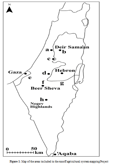
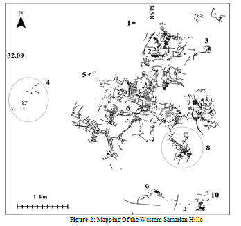
The Western Samarian Hills (Figures 1.a; 2)
The data are based on the mapping project and on a project whose publication, while preliminary, suffices for the purposes of this article [13, 20].
Ḥorvat Dayyar (Figure 2.1)
The site measures c.40×70 m and encompasses industrial winepresses and oil presses, an open pool and rock-cut cisterns. It includes mainly courtyards, and in one of the few rooms that was built of dressed stones, a stone column was found, along with a curved wall identified as an apse, and a scattering of floor mosaic tesserae [13]. Square field towers, dammed wadis and slope systems were documented on the outskirts of the site.
Ḥorvat Barid (Figure 2.2)
The site measures 50×50 m and contains two structures and large courtyards: One of the structures, measuring 12×14 m, comprised an oil press and a room built of dressed stones containing floor mosaic tesserae, which allow it to be identified as a chapel. The second structure, consisting of one room measuring c.7×12 m, was built of dressed stones, and can also be identified as a chapel. The site also includes a rock-cut cistern and an open pool with a volume of 500 cu m.
Ḥorvat Kaspah (Figure 2.3)
This site has been excavated [9, 13]. It measures c. 80×180 m and contains courtyards of various sizes, two industrial winepresses, five industrial oil presses, and a room paved with floor mosaic tesserae that can be identified as a chapel.
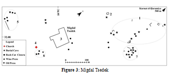
Migdal Tsedek (Figures 2.4; 3)
In an area measuring c.250×750 m, the following elements were mapped: 1. Remains of small structures and small winepresses measuring 1–2×2–3 m, small olive crushing basins c.2 m in diameter, cisterns, and burial caves; 2. Tomb of Sheikh Baraz ed-Din from the Ottoman period; 3. A fortress from the Ottoman period (Migdal Tsedek); 4. Remains of a church abutting a dammed wadi; 5–7. Clusters of small agricultural installations. The area is situated on the outskirts of Kurnat al-Ḥaramiya, a Samaritan village with remains from the eighth century BC to the twelfth century AD [13].
Kasr es-Sett (Figure 2.5)
A scattering of structures from the eighth to the fourth centuries BCE. And small agricultural installations in an area of 0.5 sq. km, apparently associated with Kurnat al-Ḥaramiya.
Ḥorvat Teena (Figure 2.6)
A monastery containing a church dated to the sixth to eighth centuries CE with a possible earlier phase, an industrial oil press, three industrial winepresses, a threshing floor and 10 square field towers [13]. The importance of the site is in reinforcing the possibility of identifying rooms as chapels, based on the quality of their construction and architectural items such as dressed stones and pillars – identification made in surveys, before the excavations – and the possibility that the monasteries may have continued in existence longer than the agricultural installations. In this context, the reduction in size of the industrial oil presses at the site at the end of the sixth century is noteworthy, as it reflects the move to food production for self-consumption [13]. OSL testing dated the terraces on the slopes of the wadis around the site from the Hellenistic to the Byzantine periods the problematic nature of soil-dating systems in agricultural terraces will be discussed below [20].
Ḥorvat Ḥammam (Figure 2.7)
A structure measuring c.13×19 m, built of dressed stones [1] . Floor mosaic tesserae and a column were found in one room, which measures c.3×5 m, which allow its identification as a chapel.
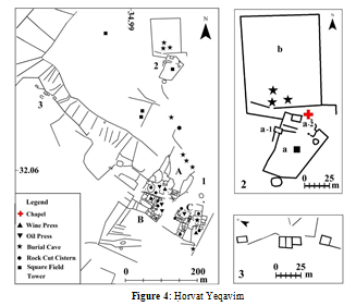
Ḥorvat Yeqavim (Figures 2.8; 4)
Three contemporaneous sites, the connection between which is not clear, were found abutting a dammed wadi around this site. 1. Ḥorvat Yeqavim (Figure 4.1), measuring c.150×180 and consisting of three units: Unit A consisted of three structures with a number of rooms, a courtyard, an industrial winepress, an oil press, three cisterns, and livestock pens measuring c.6,000 sq m; Unit B measured c.50×50 m, half of which are courtyards; it too featured industrial oil presses, as well as five cisterns; Unit C measures c.70×70 m and includes mainly courtyards, a number a burial cave; 2. A monastery (Figure 4.2) consisting of two compounds surrounded by walls c.1 m wide, and a chapel: Compound A, measuring 40×65 m and includes a gatehouse (a- 1) and a chapel (a-2), measuring c.6×9 m, whose walls were built of dressed stones and also contained floor mosaic tesserae, and Compound B, measuring 80×100 m with three rock-cut tombs. 3. Three structures (Figure 4.3) in whose walls fences were incorporated that surrounded portions of the dammed wadi.
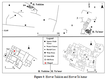
Ḥorvat Tukkim (Figures 2.9; 5)
The site measures c.40×70 m and contains a cluster of four structures. The structure at the highest point, which measures 20×25 m, was built of dressed stones [13]. A column drum and floor mosaic tesserae suggest that one of its rooms was used as a chapel. Four cisterns were also documented, along with an open pool, two industrial winepresses and an industrial oil press, a lime kiln, and three burial caves. The large number of courtyards and the small number of dwelling rooms is of particular note.
Ḥorvat Ta‘amur (Figures 2.10; 5)
The site, measuring 60×100 m, contains six structures [5, 13]. Most of the space consists of large courtyards alongside a very small number of dwelling rooms. Two industrial oil presses were documented, as well as 14 cisterns, which facilitate identification of the courtyards as livestock pens.
Fortified Monasteries in Samaria (Figure 1.b)
The site measures c.40×70 m and contains a cluster of four structures. The structure at the highest point, which measures 20×25 m, was built of dressed stones [13]. A column drum and floor mosaic tesserae suggest that one of its rooms was used as a chapel. Four cisterns were also documented, along with an open pool, two industrial winepresses and an industrial oil press, a lime kiln, and three burial caves. The large number of courtyards and the small number of dwelling rooms is of particular note.
This area was not included in the mapping project, however, data that has been published elsewhere indicate that runoff agriculture continued to expand eastward [21, 5]. The special aspect of this region, which was populated by Samaritans, is that the monasteries adjacent to the runoff agriculture system, such as Deir Sama‘an and Deri Qal‘a, were surrounded by walls and defined as fortified monasteries [8, 9, 22, 13]. The area within the walls resembles the sites described above, including chapels, churches, industrial oil presses and winepresses, courtyards and a few dwelling rooms. In contrast to other areas in the Levant, Samaria saw numerous rebellions against Byzantine rule in the sixth century CE as well.
The Modi‘in Region (Figures 1.c.; 6)
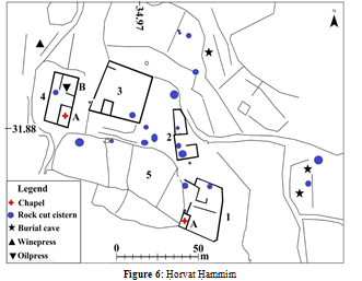
The runoff agricultural area in this region has been presented in the past, and the intention here is to present the results of re-examination of the ground plan of one site identified as a monastery, Ḥorvat Ḥammim (Figure 6). The site consists of five structures surrounded by a dense runoff agriculture system [23]. The prominent elements are: Room 1A, measuring c.4.5×8.5 m, built of dressed stones and containing floor mosaic tesserae that enable its identification as a chapel. Room 4A, measuring 6×12 m, has walls built of dressed stones, containing floor mosaic tesserae and the fragment of a column. Room 4B contains an industrial oil press; Structure 5 is an animal pen measuring c.3, 500 sq m. Some 20 cisterns were documented, next to most of which were stone troughs.
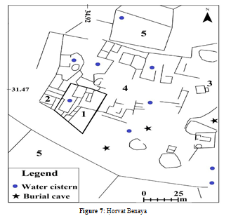
The Western Hebron Hills (Figures 1.d.; 7)
The mapping of the area revealed a dense runoff agricultural system [23-25]. Presented here is the example of Ḥorvat Benaya (Figure 7), which measures 100×150 m and contains:
1. A structure measuring c.30×40 m built of dressed stones in particularly high-quality construction, which can be identified as a monastery;
2. An industrial oil press;
3. An industrial winepress;
4. A courtyard complex identified as livestock pens;
5. Dammed wadis.
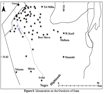
The Besor Region (Figures 1.e.; 8)
The region has been discussed in the context of the historical sources that relate to Gaza in the Byzantine period in which numerous monasteries were documented, among them 70 southeast of Gaza (Figure 8) and 55 north of Gaza [26-30]. Another prominent find in the area are two production centres for wine jars in which some 10 workshops, surrounded by large heaps of pottery waste, reflecting mass production of standard wine jars intended for export wine via the ports of Ashkelon and Gaza [31-33].
This discovery provides an additional evidence of the mass wine production in the sixth century CE. The present day environmental problem, impeding the discovery of additional sites in the region, is the dune cover, which becomes increasingly dense to the west. About 10 ruins were mapped in which the area of settlements and agricultural installations could be identified [34].A study that examined the dune cover on the south found that the settlements were covered after they were abandoned in the Early Islamic period [35].
The Beer Sheva Valley (Figure 1.f.)
Components of runoff agriculture systems and their resemblance to those farther south were identified in this region in the 1960s [36]. However, the extensive excavations carried out there later hardly mention the dammed wadis [7, 37-40]. In the late 1980s, research examined the feasibility of runoff farming in a loess region, but it did not examine the archaeological data, and the conclusion was that loess slopes are not feasible for runoff agriculture [41]. However, the current mapping project found a dense network of dammed wadis that extends uninterrupted southward to the desert [89].
2.7. The Southern Hebron Hills (Figures 1.g.; 9
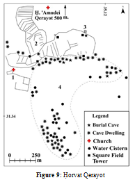
The region represents the edge of the distribution of autochthonous villages, populated by on families that had lived in the area continuously from the eighth century BCE, which do not extend past the line of annual rainfall of 250 mm. The difference between those villages and the runoff agriculture system can clearly be seen at this borderline, as at Ḥorvat Migdal Tsedek above. The churches in the region have been discussed, but mainly in a religious context, without mentioning the runoff agriculture systems adjacent to them [42-43]. The components of the two agricultural systems have been presented in the past and the presentation of one site, Ḥorvat Qerayot (Figure 9), will suffice to highlight the difference between them. The site includes: 1. An excavated church dated between the sixth and eighth centuries CE, whose construction was associated with the conversion to Christianity of the inhabitants of this autochthonic village [25, 44]. The mapping shows that the church was located outside the village. 2. Dammed wadis, one of which reaches as far as the site of Ḥorvat ‘Amudei Qerayot, a monastery c.22×23 m in size [42]. 3. An industrial winepress; 4. Remains of the village of Qerayot, extending over c.0.5 sq km including small agricultural installations, burial caves and the remains of structures. The area was severely disturbed during the Ottoman period, when the substructures of the ancient buildings were re- used as dwellings [45].
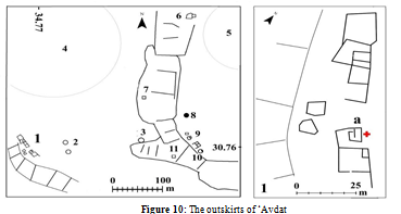
Outskirts of Avdat (Figures 1.h.; 10)
The findings from the mapping project presented in the past, have been further enriched by the intensive mapping of the area carried out thereafter [25, 34, 46]. Interest in the discoveries from the later mapping project focuses on two structures (Figure 10.1) located 2.5 km south of Avdat, which could be identified as monasteries only after a re-examination of the later mapping project data. The elements in the illustration are:
1. two structures, measuring 5×20 m and 5×10 m, which were built of dressed stones. In room a, fragments of roof tiles and floor mosaic tesserae were found, which lead to the possible identification of this room as a chapel; 2, 3, 10. Threshing floors up to 10 m in diameter [47]. Square field tower8 [47]. A cistern; 9. Three Umayyad-period farmhouses.
Discussion
The focus on the components of the runoff agricultural system has led to the conclusion that the system may represent only part of the period of the existence of the adjacent settlements. One example of such a focus is the rise and fall of wine production in the Negev with regard to Shiva, without considering elements of its agricultural periphery [48]. However, when looked at together, one realizes that all the elements revealing a spike in agriculture in the sixth century CE in the area examined are also identified at Shivta: the runoff system on its outskirts – and the addition of monasteries and industrial winepresses in the town itself.
Even the studies that present a broader view than this one, which also includes the perspective of climate change, relate to central settlements and not to the periphery [87]. But it is enough to acknowledge that such changes influence different societies in different ways – an example being the runoff system versus the agriculture of the autochthonous settlements in the Levant – to rule out the possibility of a single formula accounting for the rise and decline of all the settlements in a certain area [49].
Chronology
The Agricultural Periphery
The dating of the field towers to the second half of the sixth century, such as in areas of Avdat and Beer Sheva, have led to the assumption that the runoff system was short-lived [47, 37, 50]. The towers are the only installations that can be dated, based on a sealed stratum abutting a wall and quite a rich find of pottery and coins; the rest of the installations and the dams are open- air elements whose dating, no matter what dating technology is used, should be re-evaluated. With regard to the industrial winepresses, in numerous excavations, the end of their use was dated to before the end of the Byzantine period [4, 7, 51-52]. Moreover, the standard wine-jar production in the Besor kilns has been dated to the late Byzantine period [53-54].
Some scholars attributed the end of wine production to the religious ban introduced at the beginning of the Umayyad period however, the ban was only actually enforced in the Abbasid period and thus another reason should be sought for the end of wine production [31, 55]. It seems that industrial oil presses also ceased use at that time. In the publications of excavations of monasteries in the area of the mapping project, only at the abovementioned Ḥorvat Kaspah did the possibility arise of continued use of the oil press in the Early Islamic period. In contrast, for example, at nearby Ḥorvat Teena, use also continued, but the installation was reduced in size.
Another challenge has to do with the results of soil dating in the dammed wadis, where even advanced technological dating methods have been criticized, because the soil tested was fill, not a sealed stratum. In the Negev Highlands, for example, the soil was dated to a lengthy period, which also included meagre settlement [56-58]. The mapping project brought to light the possibility that the soil’s broad chronological span is due to the fact that it was raked from the slopes to the dammed wadis and included remains from various periods [1]. Support for this assumption was found in OSL testing of the dams in the southern, barren Negev, which revealed shorter dating spans [59]. The explanation given for this was that the soil that was raked from the slopes to the wadi did not include earlier remains because the extreme desert character of the area precluded settlement.
Management of the Agricultural Systems
As mentioned, excavations show that not all sites that can be defined as monasteries were built or ceased existence at the same time. Thus, discussing them separately from the adjacent farming system can be misleading. Research has shown three phases of settlement in the monasteries. The early phase included the monastic movement of Jerusalem that began in the third century CE, which saw monasteries abutting agricultural zones in the Judean Desert, irrigated by slope runoff, flooding streams and springs [60-62]. An additional monastic movement was established in the fourth century CE in Gaza by Christians fleeing from Egypt [26]. The agricultural aspect of this phase in the Negev, which became part of the Gaza monastic movement (Figure 10), is reflected in the refuse heaps at Shivta from the fifth century CE, before the period attributed here to the damming of the wadis [63]. These heaps contained seeds from grain, grapes, dates, olives, and figs, as were also found in, and they resemble those of the recent Bedouin in the Negev [64-65].
The conclusion is that in the areas of the ancient Negev towns, where rainfall is an annual 80–100 mm, a variety of crops can be grown on the banks of flooding wadis and by taking advantage of slope runoff, even without systematic damming of the wadis. This assumption is supported by the existence of simple agricultural terraces documented in the area, which attest to limited food production for self-consumption [3, 66-67]. The height of this phase, the sixth century CE, experienced a spike, including the establishment of runoff agriculture systems and the addition of large number of monasteries and facilities, indicating large-scale food production. The late phase reflects the decline of settlement in those monasteries that persisted in the Umayyad period mentioned above, such as at Avdat and Shivta, which continued in existence until the eighth century CE, and at Nitzana, until the ninth century CE [68-70].
Focuses of Economic Activity
The most prominent activity reflected in the runoff system installations is the mass production of wine and olive oil from Beer Sheva northward, and the raising of livestock. This conclusion stems from the ground plans of sites mentioned above, which may be identified not only as monasteries, but also as food production facilities, because almost their entire area consists of livestock pens and industrial winepresses and oil presses. The question then becomes – who consumed food products that were then being obtained throughout the Mediterranean basin specifically from the Levant, and what led to the cessation of production at the end of the sixth century CE, after only a few decades?
Flexible Compatibility to the Surroundings
Areas included in the mapping project revealed compatibility with the natural environment as well as with the geopolitical reality.
Compatibility with Local Precipitation
Runoff agriculture in the Negev functioned where annual precipitation is between 80 and 100 mm per year. A piece of information that is sometimes ignored is that runoff agriculture does not function in drought years, which in the Negev are more numerous than rainy years.
Thickness of the Dam Walls
A study that examined the assumptions that runoff agriculture in the Negev was established during better climate conditions than today has ruled out this possibility, due to the thickness of the dam walls in first-order wadis, which is c 1 m. It was found that the thickness depends on the pressure of the runoff, which is similar to the pressure exerted by the amount of precipitation of today; a greater amount of rain would break through the walls [71]. This conclusion helped explain the reason for the greater thickness of the dam walls north of the Negev, to as much as 2 m in first-order wadis, as measured in the mapping project.
Runoff Drainage Area
More support for the assumption that climate conditions have not changed can be found in an examination of the rain runoff areas of the wadis: The broad drainage area of the Negev augments the effect of the rainfall through the dammed wadis from 80 to c.400 mm per year while in the rainier southern Hebron Hills, the drainage area is reduced to the slopes on either side of the wadis, which increases the effect of the rainfall from 300 to c.400 mm per year [2, 72]. This additional runoff is especially important in drought years, which are common in the region, during which rainfall declines to less than 200 mm a year; in such years, the inhabitants of the autochthonous villages whose fields are fed by direct rainfall suffered from the drought, but the farmers cultivating the dammed wadis do not.
The Effect of the Rain Shadow
The sites in western Samaria (Figure 2) are scattered through a valley c.50 km long and 3–10 km wide, defined as the area of the rain shadow, because rainclouds pass over it without dropping rain. Thus, this specific valley is considered an arid zone, although it is in a region where annual precipitation is c.500 mm [13]. With regard to the two patterns of settlement in the area, the distribution of settlements is unequivocal: The runoff agriculture that is also suitable in the desert is densely distributed in the arid centre of the area, while the Samaritan villages mentioned above, whose existence depends on the natural environment, are found only on its margins.
Suitability to the Geological-Geomorphological Structure The runoff system northwest of the Besor Stream reflects suitability to a region meagre in natural rock outcroppings from which building stone can be quarried. Thus, its components are identical to those in other areas except that structures and installations are built of bricks coated with plaster, churches were built of beach rock that was brought from the coast and cisterns were dug into the loess soil and lined with bricks whose inner face was coated with plaster.
Suitability of the Location of the Autochthonous Villages Runoff systems in the sedentary region are often found on the outskirts of the autochthonous Samaritan villages in the north, and the Judean villages in the south, which feature small agricultural installations that reflect family activity [25]. The location of these agricultural areas highlights this difference; while runoff agriculture is based on engineering the wadis, whose use for simple, family-based farming is limited, the farming areas of the autochthonous villages are situated between the wadis and are fed only by direct rainfall.
Geopolitical Suitability
The fortified monasteries in the region of the Samaritan revolt reveal another aspect of suitability to the surroundings, in this case exerting control over the region as a kind of substitute for military presence. Indirect reinforcement for this possibility is found in the Nitzana Papyri from the sixth century CE, which document the transfer of government from the army to the Church, also seen in the transformation of the acropolis fortress into a monastery [73-75]. Evidence of this transfer of administration has also been noted in other studies in the Negev and possibly also in Petra [14, 76, 77].
Conclusion
The Relevance of the Question of Climate Change in the Levant
In terms of the runoff system, it makes no difference whether the climate was wetter or drier, because the system can be suited to any quantity of precipitation, from 80 mm a year in the desert to 600 mm a year in the north.
Global Crises and the Increase in Food Production in the Levant
Dating the agricultural runoff system to the second half of the sixth century CE makes possible the association of its establishment with the climate crisis in Europe that came about due to the volcanic eruption in 536 CE [78-79]. The eruption did not harm the southern margins of the Byzantine Empire, hence the demand for food products from that region. The problem of squeezing the damming of the wadis into that framework cannot be ignored, but a re-examination of the data did not rule out the possibility that the soil was raked into the wadi by the dam- builders, and not in lengthy, natural process of soil erosion, as has been suggested in the past [1].
The Effects of Imperial Administration
A series of questions involving the functioning of the agricultural runoff system requires discussion of the possibly greater effect of imperial administration than necessarily that of local exigencies. Significantly, the hand of the imperial administration at this time is visible in the reorganization of the three provinces of Palestine, and the completed unification of the monastic movements of Jerusalem and Gaza at the time of Justinian, as well as the attracting of population from all over the Mediterranean basin, and placing the Church at the head of the system [80]. The mass production of specific food products may reflect a demand dictated from above, which can explain both the gap between what could be grown in a certain area due to environmental conditions and what was actually grown, and the possibility that the system was not utilized to its fullest extent. One example of this is grain cultivation, which requires its own discussion because the Byzantine Empire relied on its import, mainly from Egypt [81]. Finds indicating grain cultivation, such as threshing floors, silos and sickle blades, which are common in other periods, are almost totally absent in the agricultural runoff system and in the excavations in settlements.
For comparison’s sake, a survey of the runoff agricultural system in Libya, which operated until the seventh century CE, revealed extensive distribution not only of oil presses, as in the Levant, but also grain silos [82, 83]. Agricultural research has found that there is no environmental impediment to cultivating grain in the Negev, except in drought years [2]. In fact, findings associated with grain were discovered in Shivta and Nitzana, as mentioned above. Farms dating from the Umayyad period reveal numerous threshing floors, grain storage facilities and iron sickles [84]. In contrast, on the outskirts of the ancient Negev towns, almost no installations have been found that can attest to grain cultivation, and the few silos that have been documented, such as in Figure 10, were usually found near farmhouses from the Umayyad period. In this context, it should be noted that the dates of most of the Nitzana Papyri relating to grain cultivation are from the Umayyad period. Nevertheless, it must be noted that in the Negev Highlands a good harvest can be had on the average once in seven years, which might be the reason grain was not grown for the empire [64, 15].
The same is true with regard to the meagre evidence of olive oil production south of Beer Sheva, considering that there is no environmental impediment to such production , notwithstanding the abovementioned finds of olive seeds at Shivta and Nitzana from the fifth century CE should be noted in this regard [2 ,65]. The two olive crushing stones that were found near Avdat and near Shivta do not change the picture of meagre olive cultivation [14, 67].
Thequestion is – what was cultivatedby means of runoff agriculture in the Negev in the sixth century CE; evidence indicates only the cultivation of grapes, and even that is problematic because of the small number of industrial winepresses actually discovered compared to those found in the sedentary land [85]. One theory is that the dammed wadis were intended to provide natural green pasturage to raise sheep [47]. The problem with that theory is that in the Negev, few extensive livestock pens can be identified in Byzantine-era sites, as opposed to their large number in the sedentary land and their high frequency at nomadic sites in the southern Negev Highlands.
It seems that the actual functioning of the runoff system in the Negev, despite the huge investment in their construction, should be re-evaluated. Possible support for this view can be found in the damming of Wadi el-Arish in Sinai, some 30 km west of the Negev Highlands, which drains an area of 20,000 sq km, through which about 1 billion cu m of water flow in flood season [86].
Satellite photos have made possible the estimation of the dammed area of Wadi el-Arish at about 1,000 sq km – three times the dammed area of the Negev Highlands [24]. Significantly, most of the wadi is in a hyper-arid, unsettled area, based on the data collecting in the field so far, and presumably, based on the data collected from the abovementioned studies, the wadi was prepared for use at a huge investment, but apparently saw limited actual use. It is possible that not all the imperial administration’s plans were implemented, and in any case, it cannot be ruled out that one reason for the cessation of food production, as for its start, was a system-wide decision made after farming in Europe came back at the beginning of the seventh century CE.
The preference to ascribe the decline of Byzantine runoff agriculture to administrative rather than climatological reasons finds support in the sharp rise in the distribution of farms dating to the Umayyad period in the Negev Highlands, mainly in areas south of the distribution of the Negev cities, which can be related to the sedentarization of the nomads, whose numbers increased in the region in the Byzantine period, by the Umayyad authorities, at the same time as the decline of the Negev towns [84, 34]. To this must be added continued agricultural production in the autochthonic settlements and those from the monasteries that continued in existence, whose economy declined to food production for self-consumption [88-90].
Funding
The author received no financial support for the publication of this article.
The fieldwork of the research program between 2004 and 2016 was made possible by grants from the International Arid Lands Consortium (IALC):
http://www.mnemotrix.com/adasr, https://ialc.world/projects/ ancientâ?desertâ?
agricultureâ?systemsâ?revived, and by the Krauthammer, Kushitzky and Moskowitz foundations of behalf of Martin Szuss Department of the Land of Israel and Archaeology Studies in Bar Ilan University, with collaboration of the Israel Antiquities Authority.
References
- Haiman, M. M. (2022). Integrating Archaeological Data in Multidisciplinary Environmental Studies—Methodological Notes from High-Resolution Mapping of Ancient Features in Southern Israel. Heritage, 5(2), 1141-1159.
- Evenari, M., Shanan, L., & Tadmor, N. (1971). The Negev: The challenge of the desert. Harvard University Press. Kedar, Y. (1967). The ancient agriculture in the Negev mountains.
- Ayalon, E. (1997). The end of the ancient wine industry in the central coastal plain. Hikrei Eretz: Studies in the History of the Land of Israel, Dedicated to Prof Yehuda Feliks. Ramat Gan, 149-166.
- Safrai, Z. (1997). Settlements in the Shomron Shephela in the Byzantine period. Judea and Samaria Research Studies, 6, 217–234.
- Haddad, E., & Zwiebel, E. (2021). Khirbat Ibreika: Archaeological evidence for the retaliation of the Byzantine regime following the Samaritan revolts. Judea and Samaria Studies, 30(2), 153–188.
- Israel, Y., & Erickson-Gini, T. (2013). Remains from the Hellenistic through the Byzantine periods at the ‘Third Mile Estate’, Ashqelon’. Atiqot, 74, 167-222.
- Hirschfeld, Y. (2002). Deir Qal'a and the monasteries of western Samaria. Journal of Roman Archaeology- Supplementary Series-, 49, 155-190.
- Magen, Y. (2008). Oil Production in the Land of Israel in the Early Islamic Period. Judea and Samaria: Researches and discoveries, 257-343.
- MÃÃÂ??ÂÃÂ?ÂÂgÃÃÂ???n, Y. (2008). Judea and Samaria Publications/7 The Samaritans and the good Samaritan/Yitzhak Magen. Judea and Samaria publications= JSP.
- Taxel, I. (2008). Rural monasticism at the foothills of southern Samaria and Judaea in the Byzantine period: Asceticism, agriculture, and pilgrimage. Bulletin of the Anglo-Israel Archaeological Society, 26, 57–73.
- Dayan, A. (2015). Monasteries in the northern Judean Shephelah and the Samaria western slopes during the Byzantine and the Early Islamic periods. Unpublished Phd. Thesis, Bar-Ilan University.] Ramat-Gan (Hebrew with English summary).
- Shadman, A. (2016). The settlement pattern of the rural landscape between Nahal Rabbah and Nahal Shiloh during the Hellenistic: Roman and Byzantine Periods. PhD thesis, Bar-Ilan University.
- Rubin, R. (1990). The Negev as a settled land: Urbanization and settlement in the desert in the Byzantine period. Jerusalem: Yad Ben Zvi (in Hebrew).
- Stroumsa, R. (2008). People and identities in Nessana Duke University.
- Barker, G., Gilbertson, D. D., Jones, B., & Mattingly, D. (1996). Farming the desert: the UNESCO Libyan valleys archaeological survey.
- Van der Veen, M., Grant, A., & Barker, G. (1996). Romano- Libyan agriculture: Crops and animals. In G. Barker (Ed.), Farming the desert: The UNESCO Libyan Valleys Archaeological Survey, Vol. 1: Synthesis (pp. 227–263). London.
- Ashkenazi, J., Aviam, M., Bottini, G. C., ChrupcaÃÃÂ???a, L. D., & Patrich, J. (2014). Small monasteries in Galilee in late
- antiquity: The test case of Karmiel. Knowledge and wisdom: Archaeological and historical essays in honour of Leah Di Segni (= Studium Biblicum Franciscanum. Collectio Maior 54), 161-178.
- Hull, D. (2008). A spatial and morphological analysis of monastic sites in the Northern Limestone Massif. Levant, 40(1), 89–113.
- Shadman, A. (2019). Rosh Ha-‘Ayin (South and East Hadashot Arkheologiyot, 131, 1–31.
- Dar, S. (1986). Landscape and pattern. An archaeological survey of Samaria 800 BCE-636 CEP 1. BAR/International series, 308.
- Magen, Y., & Aizik, N. (2012). A Late Roman Fortress and a Byzantine Monastery at Deir Qal ‘a. Christians and Christianity III: Churches and Monasteries in Samaria and Northern Judea, 107-156.
- Haiman, M. (2018). From Palmer to GIS: Two survey methods on trial in the Negev Desert. In D. Gurevich & A. Kidron (Eds.), Exploring the Holy Land: 150 years of the Palestine Exploration Fund (pp. 179–198). Sheffield.
- Haiman, M. (2012). Dating the agricultural terraces in the southern Levantine deserts: The spatial-contextual argument. Journal of Arid Environments, 86, 43–49.
- Haiman, M. (2018). The challenge of digitized survey data. In T. E. Levy & I. W. N. Jones (Eds.), Cyber-archaeology and grand narrative (pp. 111–122). New York.
- Bitton-Ashkelony, B., & Kofsky, A. (2000). The monasticism of Gaza in the Byzantine period. Qatedrah le- tôldôt Eres Yísra'el el we-yîššûbah, (96), 69-110.
- Di Segni, L. (2004). The territory of Gaza: notes of historical geography. In Christian Gaza in late antiquity (pp. 41-59). Brill.
- Hirschfeld, Y. (2004). The monasteries of Gaza: An archaeological review. In A. Kofsky & B. Bitton-Ashkelony (Eds.), Christian Gaza in late antiquity (pp. 61–88). Brill.
- Gazit, D. (1986). á¿?evel ha-Bésor. Tel Aviv: Hebrew.
- Huster, Y. (2015). Ashkelon 5: The land behind Ashkelon. Eisenbrauns.
- Mayerson, P. (1985). The wine and vineyards of Gaza in the Byzantine period. Bulletin of the American Schools of Oriental Research, 257, 75–80.
- Israel, Y. (1993). Survey of pottery workshops, Naḥal Lakhish - Naḥal Besor. Hadashot Arkheologiyot, 100, 91– 93.
- Gadot, Y., & Tepper, Y. (2003). A late Byzantine pottery workshop at Khirbet Baraqa. Tel Aviv, 30, 143–148.
- Haiman, M. (2020). Between Nessana and Ashkelon: Mapping Agricultural Systems of the 6th–8th Centuries CE. Ashkelon and Its Environs: Studies of the Southern Coastal Plain and the Judean Foothills in Honor of Dr. Nahum Sagiv. Tel Aviv, 229-264.
- Roskin, J., Katra, I., & Blumberg, D. G. (2013). Late Holocene dune mobilizations in the northwestern Negev dunefield, Israel: A response to combined anthropogenic activity and short-term intensified windiness. Quaternary International, 303, 10–23.
- Ilan, Z. (1980). Traces of early agriculture in the region of Katef Beer-Sheva. Nofim, 15, 17–22.
- 37. Fabian, P., & Goldfus, H. (2004). A Byzantine Farmhouse, Terraces and Agricultural Installations at the Goral Hills near Be'er Sheva'. 'Atiqot/ÃÂ?ªÃÂ??ÃÂ?§ÃÂ??ÃÂ?ªÃÂ?¢, 209-210.f
- Sontag, F. (2012). Be’er Sheva. Hadashot Arkheologiyot, 124. Retrieved from
- Eisenberg-Degen, D., & Kobrin, F. (2016). Be’er Sheba‘, Nahal ‘Ashan, Newe Menahem B. Hadashot Arkheologiyot, 128.
- Yair, A. (1987). Environmental effects of loess penetration into the northern Negev desert. Journal ofArid Environments, 13, 9–24.
- Hirschfeld, Y. (1989). Horvat ÃÃÂ??»Amudei Qerayot. Excavations and Survey in Israel, 7–8, 3–4.
- Eshel, H., Magness, J., & Shenhav, E. (2000). Khirbet Yattir, 1995–1999: Preliminary report. Israel Exploration Journal, 50, 153–168.
- Govrin, Y. (2007). á¿?orvat Qerayot – An early Christian settlement at the desert fringe. In Y. Eshel (Ed.), The Frontier Desert of Eretz-Israel, Proceedings of the 2nd Annual Meeting (pp. 59–76). (Hebrew).
- Grossman, D. (1994). Expansion and desertion, the Arab village and its offshoots in Ottoman Palestine. Jerusalem. (Hebrew).
- Sion, O., Ashkenazi, E., & Erickson-Gini, T. (2022). Byzantine 'Avdat and its agricultural hinterland. In A. Golani, D. Varga, Y. Tchekhanovets, & M. Birkenfeld (Eds.), Archaeological Excavations and Research Studies in Southern Israel, 18th Annual Southern Conference, Ben Gurion University and Israel Antiquities Authority (pp. 18– 25). (Hebrew).
- Nevo, Y.D. (1991). Pagans and herders: A re-examination of the Negev runoff cultivation systems in the Byzantine and early Arab periods. Sde Boker, Israel.
- Fuks, D., Bar-Oz, G., Tepper, Y., Erickson-Gini, T., Langgut, D., Weissbord, L., & Weiss, E. (2020). The rise and fall of viticulture in the late antique Negev Highlands reconstructed from archaeobotanical and ceramic data. Proceedings of the National Academy of Sciences, 117(33), 19780–19791.
- Rosen, A.M. (2007). Civilizing climate: Social response to climate change in the ancient Near East. Lanham, MD.
- Sontag, F. (2000). Beer Sheva, Ramot. Hadashot Arkheologiyot, 111, 91–92.
- Sidi, N., Amit, D., & Ad, U. (2000). Two winepresses from Kefar Sirkin and Mazor. 'Atiqot, 44, 254–266.
- Avshalom-Gorni, D., Frankel, R., & Getzov, N. (2008). A Complex Winepress from Mishmar Ha-'Emeq: Evidence for the Peak in the Development of the Wine Industry in Eretz Israel in Antiquity. 'Atiqot/ÃÃÂ??ªÃÃÂ???ÃÃÂ??§ÃÃÂ???ÃÃÂ??ªÃÃÂ??¢, 65-67.
- Majcherek, G. (1995). Gazan amphorae: Typology reconsidered. In H. Meyza & J. Mlynarczyk (Eds.), Hellenistic and Roman pottery in the Eastern Mediterranean- advances in scientific studies (pp. 163–178). Warsaw.
- Oked, S. H. (2001). Gaza Jar”: A Chronicle, and Economic Overview. Ashkelon: A City on the Seashore. Ashqelon, 227-250.
- Sharon, M. (1985). Appendix: Arabic inscriptions from Sede-Boqer – Map 167. In R. Cohen (Ed.), Archaeological survey of Israel, Map of Sede-Boqer – West (167) (pp. 31– 35). Jerusalem.
- Bruins, H.J., van der Plicht, J., & Haiman, M. (2012). Desert habitation history by C14 dating of soil layers in rural building structures (Negev, Israel): Preliminary results from Horvat Haluqim. In E. Boaretto & N.R. Rebollo Franco (Eds.), Proceedings of the 6th International Radiocarbon and Archaeology Symposium. Radiocarbon, 54(3–4), 391– 406.
- Avni, G., Porat, N., & Avni, Y. (2013). Byzantine-Early Islamic agricultural systems in the Negev Highlands: Stages of development as interpreted through OSL dating. Journal of Field Archaeology, 38(4), 332–346.
- Gibson, S. (2015). The archaeology of agricultural terraces in the Mediterranean zone of the Southern Levant and the use of the Optically Stimulated Luminescence dating method. In B. Lucke, R. Bäumler, & M. Schmidt (Eds.), Soils and sediments as archives of environmental change. Geoarchaeology and landscape change in the subtropics and tropics (Erlangen, Erlanger Geographische Arbeiten 42, pp. 295–314).
- Stavi, I., Ragolsky, G., Haiman, M., & Porat, N. (2021). Ancient to recent-past runoff harvesting agriculture in the hyper-arid Arava Valley: Dating and insights. The Holocene, 31(6), 1047–1054.
- Patrich, J. (1995). The Judean Desert Monasticism in the Byzantine Period: The Institutions of Sabas and His Disciples. Jerusalem (Hebrew).
- Di Segni, L. (2001). Monk and society: The case of Palestine. In J. Patrich (Ed.), The Sabaite heritage in the Orthodox Church from the fifth century to the present (pp. 31–36). Leuven: Orientalia Lovaniensia Analecta 98.
- Hirschfeld, Y. (2002). The Desert of the Holy City: The Judean Desert Monasteries in the Byzantine Period. Jerusalem (Hebrew).
- Fuks, D., Weiss, E., Tepper, Y., & Bar-Oz, G. (2016). Seeds of collapse? Reconstructing the ancient agricultural economy at Shivta in the Negev. Antiquity, 90(353), 1–5.
- Mayerson, P. (1962). The ancient agricultural regime of Nessana and the central Negev. In H.D. Colt (Ed.), Excavations at Nessana (Auja Hafir, Palestine), Vol. 1 (pp. 224–269). London.
- Ashkenazi, E., Chen, Y., Avni, Y., & Lavee, S. (2015). Fruit trees’ survival ability in an arid desert environment without irrigation in the Negev Highlands of southern Israel. Israel Journal of Plant Sciences, 62(1–2), 5–16.
- Evenari, M., Aharoni, Y., Shanan, L., & Tadmor, N. (1958). The ancient desert agriculture of the Negev III: Early beginnings. Israel Exploration Journal, 8, 231–268.
- Lender, Y. (1990). Archaeological survey of Israel, Map of Har Nafḥa (196). Jerusalem.
- Taxel, I. (2013). From prosperity to survival: Rural monasteries in Palestine in the transition from Byzantine to Muslim rule (seventh century AD). In P.R. Preston (Ed.), Mobility, transition and change in prehistory and classical
- Tepper, Y., Porat, N., & Bar-Oz, G. (2020). Sustainable farming in the Roman-Byzantine period: Dating an advanced agriculture system near the site of Shivta, Negev desert, Israel. Journal of Arid Environments, 177, 1–20.
- past 2,500 years. Nature, 523(7562), 543-549.
- Urman, D. (2004). (Ed.). Nessana: Excavations and studies, Vol. 1. Beer Sheva, Beer Sheva 17.
- Yair, A. (1994). The ambiguous impact of climate change at a desert fringe: Northern Negev, Israel. In A.C. Millington & K. Pye (Eds.), Environmental change in drylands: Biogeographical and geomorphological perspectives (pp. 199–227). Hoboken, NJ.
- Ackermann, O., Svoray, T., & Haiman, M. (2008). Nari (calcrete) outcrop contribution to ancient agricultural terraces in the Southern Shephelah, Israel: Insights from digital terrain analysis and a geoarchaeological field survey. Journal of Archaeological Science, 35, 930–941.
- Kraemer, C.J. (1958). Excavations at Nessana, Vol. III: Non-literary papyri. Princeton.
- Colt, H.D. (Ed.). (1962). Excavations at Nessana (Auja Hafir, Palestine), Vol. 1. London.
- Mayerson, P. (1963). The desert of southern Palestine according to Byzantine sources. Proceedings of the American Philosophical Society, 107, 160–172.
- Fiema, Z.T. (2002). Petra and its hinterland during the Byzantine period: New research and interpretations. In J. Humphrey (Ed.), Roman and Byzantine Near East Volume 3 (pp. 191–252). Portsmouth: Journal of Roman Archaeology Supplementary, Series 49.
- Fiema, Z.T. (2007). The Byzantine military in the Petra papyri – a summary. In A.S. Lewin & P. Pellegrini (Eds.), the Late Roman Army in the Near East from Diocletian to the Arab Conquest (pp. 313–319). Oxford: BAR IS 1717.
- Arjava, A. (2005). The mystery cloud of 536 CE in the Mediterranean sources. Dumbarton Oaks Papers, 59, 73–94.
- Sigl, M., Winstrup, M., McConnell, J. R., Welten, K. C., Plunkett, G., Ludlow, F., ... & Woodruff, T. E. (2015). Timing and climate forcing of volcanic eruptions for the
- Mayerson, P. (1988). Justinian's Novel 103 and the reorganization of Palestine. Bulletin of the American Schools of Oriental Research, 269, 65–71.
- Teall, J.L. (1959). The grain supply of the Byzantine Empire, 330–1025. Dumbarton Oaks Papers, 13, 87–139.
- Mattingly, D. (Ed.). (1996). Farming the desert: The UNESCO Libyan valleys archaeological survey: Volume II: Site Gazetteer and Pottery. London.
- Mattingly, D., & Dore, J. (1996). Romano-Libyan settlement: Typology and chronology. In G. Barker (Ed.), Farming the desert: The UNESCO Libyan valleys archaeological survey: Volume One: Synthesis (pp. 111–158). London.
- Haiman, M. (1995). Agriculture and nomad-state relations in the Negev Desert in the Byzantine and early Islamic periods. Bulletin of the American Schools of Oriental Research, 279, 5–29.
- Mazor, G. (1981). The wine-presses of the Negev. Qadmoniot, 53/54, 51–60. (Hebrew).
- Gheith, H. M., & Sultan, M. I. (2001). Assessment of the renewable groundwater resources of Wadi El-Arish, Sinai, Egypt: modelling, remote sensing and GIS applications. IAHS PUBLICATION, 451-454.
- Izdebeski, A., Pickett, J., Roberts, N., & Waliszewski, T. (2016). The environmental, archaeological, and historical evidence for regional climatic changes and their societal impacts in the Eastern Mediterranean in Late Antiquity. Quaternary Science Reviews, 136, 189–208.
- Avni, G. (2014). The Byzantine-Islamic transition in Palestine. Oxford.
- Haiman, M., Argaman, E., & Stavi, I. (2020). Ancient runoff harvesting agriculture in the arid Beer Sheva Valley, Israel: An interdisciplinary study. The Holocene, 30(8), 196–204.
- Israel, Y., Seriy, G., Feder, O., Katsnelson, N., & Sade, M. (2013). Remains of a Byzantine and Early Islamic Rural Settlement at the Be'er Sheva'North Train Station. 'Atiqot 138-140. ,